Poverty Gulch 1-5-15

CB Avalanche Center2014-15 Observations

Name: Dustin
Title: Poverty Gulch 1-5-15
Location: Paradise Divide Area
Date of Observation: 01/05/2015
Aspect: North, East
Elevation: 9500-10500

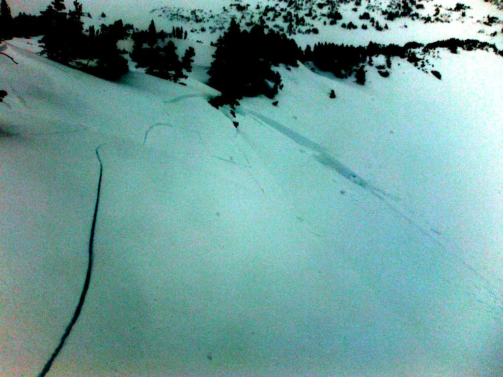
Avalanches: Triggered multiple wind slabs (all D1) while riding and one snowmobiling. The first was triggered on a small cross-loaded convexity on the bench. It was only 2-3 inches deep, seemed to be windblown snow from today. The slab didn’t have enough weight to run more than a few feet downhill, but for how small it was it propagated around 10ft. Our party triggered another, seemingly identical slide on a similar slope lower down. The third was triggered below a leeward ridge and was a little bigger (3-5 inches and 15 ft) but also didn’t run on the relatively shallow slope (25-30 degrees). The final slide was triggered on a small E-aspect on the valley floor that received tremendous wind loading. The slide was triggered from a convexity/windlip and was between 5-15 inches deep across the crown. The slide ran on a Q1 surface, beautifully planar but I couldn’t identify the weak layer between that and the stiff wind slab that was the bed surface. Sun crust or surface hoar? All R1-D1- AS-SS except the snowmobile trigger.

Weather: Windy! Clouds were in and out throughout the day but never had full sky coverage. Strong winds from the West and Northwest that were heavily loading slopes frequently throughout the day. Pretty warm besides the wind.

Snowpack: Less supportive in lower elevations and less wind affected areas. More snow up high. Dug on a small test slope on the bench below the N-face of Schuylkill false summit, seemed to receive a good bit of wind loading. Was more than 5 ft and didn,t touch the ground. Around 1-2 ft of softer snow (f and 4f) on top of a stiffer slab (1f). I imagine that this is the slab from the Dec. 22nd storm. Underneath the Dec. 22 slab was softer faceted snow, but seemed somewhat cohesive as well.

Uploads:

Mountain Weather January 5, 2014

CB Avalanche CenterWeather

Date: 01/05/2015

We are under the influence of northwest flow which is normally a good snow producer for our areas, but most of the available moister is to our north. Today we me may see a few light orographic snow showers with mostly cloudy sky. This weather will linger on Tuesday before a ridge of high pressure builds on Wednesday bringing warmer and dryer conditions. This ridge currently looks to stay in place through the week with the next possibility of change over the weekend.

Crested Butte Area

CB Avalanche Center2014-15 Observations

Name: Ben Pritchett
Location: Snodgrass
Date of Observation: 01/05/2015

Snowpack: No questions about the distribution of the Dec 13th weak layer. It’s widespread and continuous in the Crested Butte zone in the near and below treeline areas. The uncertainty with the Persistent slab problem is with distribution of the slabs themselves. Based on observations over several days around the Slate and Washington Gulch areas, seems like the collapsing happens pretty consistently (several to many a day) in undisturbed areas where there is more than 45-50cm of recent snow on the Dec 13 interface. If there is less than 40cm over the Dec 13 layer, seems like the skiing gets punchy and you’re penetrating through the slab skiing in the weak layer, surfing facets. Bottom line, in the shallower snowpack zone around town, ski pen is a pretty handy observation at the moment to track the presence or absence of the persistent slab problem across terrain features; if ski penetration is less than about 20cm, it’s likely that you’re riding on top of a slab that’s perched on a guilty weak layer. Right now, contrary to the common strategy of avoiding weak areas, it worked well to stick to the shallower weaker snow and surf the facets. I’m inclined to avoid skiing steeper slopes below treeline that feel supportive.

3 collapses, each in open areas where slab was supportive (ski pen


Axtell Avalanche

CB Avalanche Center2014-15 Observations

Location: Kebler Pass Area
Date of Observation: 01/04/2015
Aspect: North
Elevation: below treeline

Avalanches: I traversed the small, shallow, cross loaded slope toward dense trees. The slope collapsed and propagated ten feet above me and ~100 ft wide. The angle was low 30’s so it was very slow moving and I had no problem getting to the trees. The crown was about 2ft and composed entirely of dense wind slab. the top ~30ft ran on the ground and some debris slid~300ft, stopping at the trees. We also noticed an east facing slide up moonscape. It appeared to be natural, wind slab under a cornice, maybe ~50 ft wide R1 D1

Weather: cloudy, west winds ~20mph

Snowpack: We saw an old crown that seemed to propagate across the skiers right half of Axtel’s 2nd bowl. It was pretty filled in. There was not a place near the start zone that we felt comfortable digging a pit. We decided to ski corner pocket of first bowl. Lower in first bowl, the snow became more wind affected. We took the gully right, crossing scoured snow. At a high point of lower angle terrain between the exits of 1st and 2nd bowl, the slope was heavily cross loaded.

Uploads:

IMG_0553
FullSizeRender

Avalanche Snodgrass

CB Avalanche Center2014-15 Observations

Name: Peter Richmond
Location: Crested Butte Area
Date of Observation: 01/03/2015
Aspect: North East
Elevation: 10, 600

Avalanches: Yes, one large slide, after ski cut, skier traversed out of slide, the area was in the glades at the very top of slope that progressed to open area, traveled 500 ft, crown was 2-3 ft, 200 ft across at largest area, debris pile 250 ft across 5-10ft deep, broke trees 8” in diameter,

Small slides in glades the entire way to the Gothic Road, Second slide propagated into exposed 34 degree slope, from tight trees, could have also buried skier in opening

Snowpack: Very unstable, it may have been an isolated area, but there were point releases all the way down to the Gothic Road in the glades (tight trees, pocket releases, around anchors), a little wind blown layer on top, facet layer 2-3 feet deep. 32-42 degree slope angles,

Most unstable snow pack I’ve skied Snodgrass in, probably been up there 30 times over 7 years.

No prior ski compaction

Uploads:

WP_20150103_007
WP_20150103_004

Mountain Weather Janurary 4, 2014

CB Avalanche CenterWeather

Date: 01/04/2015

Northwest flow has currently set up from the Pacific Northwest to Southern Rockies. This weather pattern will keep us with partly to mostly cloudy sky’s with chances of orographic snow for the next few days. This northwest flow generally favors the western portion of our area and will be the likely zone that sees additional snow during this period, though most available moister will stay north of our area. Closer to and east of CB there will be little chance of snow and drier conditions. This pattern currently looks to break down Wednesday as a high-pressure ridge moves in.

Windslabs and variable persistent slab structure in Oh-Be-Joyful

CB Avalanche Center2014-15 Observations

Name: Zach Guy
Title: Windslabs and variable persistent slab structure in Oh-Be-Joyful
Location: Kebler Pass Area to Crested Butte Area
Date of Observation: 01/03/2015
Aspect: North, North East, South East, South, North West
Elevation: 12,000 feet to 9,000 feet

Avalanches: Widespread cracking on windloaded features and numerous touchy windslabs up to 10″ deep on SE aspects near and above treeline, running on the thin suncrust that formed yesterday. SS-ASc-R1-D1-I. See photos. Also some cracking and very thin pockets (2-3″ thick) released in relatively sheltered, northerly ATL terrain, potentially on the surface hoar layer that was observed yesterday(?) Didn’t look at the interface closely.

Weather: Overcast to broken skies. Strong NW winds, with moderate to heavy snow transport. .Moderate snowfall (S2), with about 2-4″ accumulated through the day.

Snowpack: Traversed from the headwaters of Oh-Be-Joyful basin to Slate River trailhead monitoring PS problem. Near the headwaters, at 10,000 feet in the far west end of the basin, the snowpack was 200 cm deep. In the pit, the Dec 13th facet layer was indiscernible to the naked eye and in hardness profiling, and it produced non-propagating results about 80 cm from the surface. (ECTN25, Q3 ). Moving east and gradually losing elevation, the layer became noticeable to pole probing (hollow feeling under denser slab) where the snowdepth was roughly 100 cm to 80 cm deep, just upvalley of where Peeler Basin enters Oh-Be-J at 9,600 feet. Around here we started noticing soft collapses underfoot. Further east down-valley, around 9,400 feet below the Redwell runout, the slab felt mostly gone to faceting, with easy pole probing throughout, no more collapses, and a snow depth around 40-60 cm.

Uploads:

DSCF5470
DSCF5469
DSCF5468

Kebler Pass Area

CBAC2014-15 Observations

Location: Irwin Cat Ski

GENERAL COMMENTS: Snow began in the early am and by 9:30 snow began in earnest with strong winds near and above treeline, but even still filtering into below treeline areas.  Windslabs were very touchy and growing in size 10”+ in E. Barkmarker by the afternoon.  Poor visibility prevented backcountry obs.  Storm really fired up around 1500, with that classic Irwin NW-flow nukage that was continuing as we left for the day.

East: am: Perfect loading speeds and direction for EBM. Cracks shooting 20-40’. Fresh windslabs 6-10” deep. Remotely triggered Bender from Swill and got Candy’s to clean out wall to wall while approaching the cornice mid day. D-.5 -1.

South: Sunny Shoulder had stout crust (3-5 cm), (Jan 3 interface) with only 1-2” of new snow on top in the am. New snow seems to be bonding OK with minimal sluffing.

West: UWW, Moonrise, Far Out, Sunset, feeling slabby but not yet slabbed up across extensive terrain. Classic 6-10” windslabs on little rolls behind tree islands, but not long running, or widely propagating… yet. Round two Below Moonrise two small pockets 6-8” deep 20’ wide not really running. Did seem that the new wind and snow was touchy in areas holding yesterdays SH/MFcr combo….worth watching.


Crested Butte Area

CBAC2014-15 Observations

Name: JSJ
DATE: 1/3/15
Location: Guides Ridge Climb
WEATHER: Cold !! Broken to overcast skies throughout the day. Moderate NNW by mid day transporting snow to lee slopes.
SNOWPACK/AVALANCHE OBS: persistent slab problem evident with ski pen around 15-30cm and boot pen to ground over 50% of the time. Windslabs on ridgecrest showed cracking but nothing moving. Rime(ing) found on all surfaces all the way to summit at 12,162′

Kebler Pass Area

CBAC2014-15 Observations

Name: Evan Ross
DATE: 1/3/14
LOCATION:  Evan’s Basin
ELEVATION:  9,500-11,300fr
ASPECT: SE
Weather: Tour between noon and 3pm. Obscured sky and snowing up to S2 at times. Couple inches accumulation at best. Light westerly wind in our area with no drifting snow.

Snowpack: Avoided several steep slopes and a few pillowy looking snow deposits. Other wise no obvious sings to instability. HS was near 70cm down low and up to 120cm at the higher elevations.