Date of Observation: 01/14/2015
Name: Billy Rankin
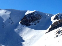
Aspect: East
Elevation: 11,000′
Avalanches: Old Avalanche way left in Bowl in classic convexity. A couple very small slides observed off West face Gothic just below ridgetop, A couple small shallow windslabs far end of Schuykil Ridge. Also small insignificant D1 or smaller.
Weather: Clear, high temps felt in the 20’s, strong solar radiation, light wind. Winds up high blowing plumes off Gothic peak and Baldy looked North, maybe North East.
Snowpack: Skied far left side of bowl, avoiding steeper convex roll. First turn of the ridge skis punched through a lot of the snowpack. On tenth turn my partner felt a small collapse right below the ridge that produced a 15′ wide crack. Skiing was feeling trap door ish with very weak mid pack. Windloading patterns on Gothic and Schuykil Ridge looked from winds out of the NNW.