Mountain Weather January 13, 2015
Date: January 13, 2015
The center of the closed low is circulating along the Nevada/Utah border this morning. There’s not as much moisture on the back end of this system, but we’ll see some continued flurries today, with the Kebler and Paradise Divide areas favored. Cooler, dryer northerly flow will fill in as the low moves east, with dry weather through the rest of the week.
Today
High Temperature: 25
Wind Speed: 0-10 mph
Wind Direction: S, SW
Sky Cover: Overcast
Snow: 2-5″
Tonight
Low Temperature: 12
Wind Speed: 3-13 mph, G25
Wind Direction: E
Sky Cover: Partly Cloudy
Snow: 0-2″
Tomorrow
High Temperature: 22
Wind Speed: 3-13
Wind Direction: NW
Sky Cover: Partly Cloudy
Snow: 0
Wet Slab off of Cinnamon
Location: Paradise Divide Area
Date of Observation: 01/10/2015
Elevation: 11500- 10000
Weather: Sunny, warm some clouds
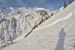
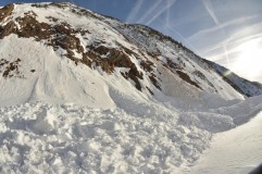
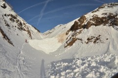
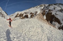
Avalanches: Wet Slab off Cinnamon ran from ice cliffs to valley bottom. 8-15 inch crown ran approximately 1500 feet and left debris at “valley of Death” 20 feet high. Appeared to be 1-2 days old.
Snowpack: Prolonged High Pressure. Facets on the North…. Melt Freeze on the Solar aspects
Uploads:
- Wet Slab off of Cinnamon 1
- Wet Slab off of Cinnamon 2
- Wet Slab off of Cinnamon 3
- Observed 1/10/15. Wet slides off of south slopes on Cinnamon
Anthracite Mesa
GUIDE(S): Scott
DATE: 01/12/2015
ACTIVITY: Ski touring
LOCATION: Anthracite Mesa/ Coneys
ELEVATION: 9,500 to 11,000
ASPECT: NE-E
WEATHER: Temps in the 20’s. Cloud ceiling of 10,500 at the trailhead, gradually rising throughout the day. Sun visible around noon, and remaining until 3. Winds calm to light throughout the afternoon.
SNOWPACK/AVALANCHE OBS: 3cm buried surface hoar layer found at all aspects and elevations where I dug including ridge top. ECT near ridgetop provided no result on the December 13th layer 80cm below the surface. HST was between 10-15cm depending on elevation, no evidence of wind transport.
Snodgrass
GUIDE(S): Donny
DATE: 15-01-12
ACTIVITY: Ski touring
LOCATION: Snodgrass
ELEVATION: 9,600’ to 11,150′
ASPECT: SE-S-SW-W-NW
WEATHER: Mostly cloudy, no precip, calm and warm. It was “Africa hot” in Wash Gulch as we toured out – a product of a greenhouse effect, I would guess.
SNOWPACK/AVALANCHE OBS: 4” of new snow from yesterday (maximum). We skied the west aspect of Snodgrass down to Wash Gulch. We had no signs of instabilities. The ski pen was 20 to 40 cm. The 12/13 interface could not be felt in the shaded areas.
Upper Slate River and Washington Gulch area
Location: Paradise Divide Area
Date of Observation: 01/11/2015
Weather: Snowfall exceeded the forecast, picking up 15cm (6″) by the end of the day, yahoo! West winds drifted the new snow as it fell.
Snowpack: 2 significant collapses on West aspects, both failing on the Dec 13 faceted interface. One slightly South of west, a second slightly North of west. On the second one, there was no old sun crust under the new snow and the slab was 4F to F+ hard, but even with the slab as not stiff as it was, it was still able to propagate ~70′ across a small 36 degree roll (see photo). Not that the Jan 11th snow changed the load on the Dec 13th layer to a great extent yet, but it’s a good reminder that as the snow loads grow, so will the distribution of the persistent slab problem, to include the weaker/shallower areas on the sunny side of the compass.
Mountain Weather January 12, 2015
Date: 01/12/2015
Crested Butte will hang in the balance between two storms today with little accumulating snow. Our atmosphere is currently primed with warm moist air, but this air needs a disturbance to help create snowfall. A low pressure trough is over Utah today and forecasted to swing south of Colorado tonight while forming a closed low. This will put us under southwest flow as we began to see this closed low affect our area tonight and tomorrow. With so much moisture in the air we could see high snowfall accumulations or the closed low could track further south and leave us skunked. This will be an interesting system to watch play out as either way our best guess forecasted snowfall numbers will likely be off. By Wednesday a flat ridge begins to build and we’ll see dry weather through the remaining week.
Today
High Temperature: 25
Wind Speed: 2-12
Wind Direction: SW
Sky Cover: Overcast
Snow: 0-2
Tonight
Low Temperature: 15
Wind Speed: 5-15
Wind Direction: SW
Sky Cover: Overcast
Snow: 3-6
Tomorrow
High Temperature: 23
Wind Speed: 2-12
Wind Direction: SE, S
Sky Cover: Overcast
Snow: 2-5
Mt. Owen
Name: Zach Guy
Location: Kebler Pass Area
Date of Observation: 01/11/2015
Aspect: South, North West
Elevation: 11,000 to 13,000 ft.
Avalanches: Touchy windslabs in crossloaded gullies, 4-8″ thick, a few up to 10″ thick. We skier triggered over a dozen soft slabs, running on meltfreeze crusts on southerly aspects and windhardened surfaces on northerly aspects. They weren’t running far or propagating wide distances, but they were increasing in size through the day. SS-ASc-R1-D1-I
Weather: Moderate snowfall, light to moderate westerly winds, some variable directions as we moved through terrain. Overcast.
Snowpack: About 6″ of new snow on the firm interfaces left over from our recent dryspell, up to 10 or 12″ in drifted gullies. New snow is bonding poorly to the Jan 10th interface.
Irwin Cat Skiing
Recent Observations: New Interface is the Jan 11th Interface and the new snow is falling on mostly crusts, Near Surface facets and Surface Hoar. This will be a one to watch especially as slabs build. Jan 3rd interface visible in profile but not reactive to column tests.
East: Evidence of more SW winds with no slab forming yet. 3‐6” of new unconsolidated snow on mostly supportive crust. Descent bonding with minimal sluffing.
West: Sluffing moving medium speeds w/ Oswald going full track not a lot of mass. See attached profile from JB Jungle
File Upload: Snow Profile


