Mt. Emmons

CB Avalanche Center2014-15 Observations

LOCATION: Crested Butte Area
DATE OF OBSERVATION: 01/24/2015
NAME: Zach Guy
SUBJECT: Mt. Emmons
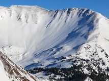
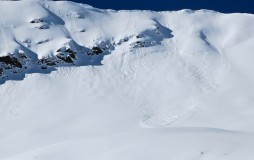
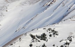
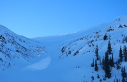
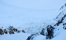
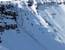
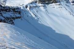
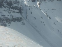
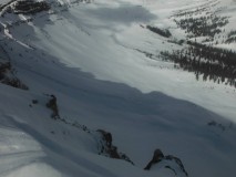
ASPECT: North, East, South
ELEVATION: 9,000 -12,000 ft.

AVALANCHES: No recent slides.

WEATHER: Broken skies. Moderate to strong winds at ridge line, elsewhere winds were light. Plumes on ridge line but didn’t seem to be actively loading.

SNOWPACK: On south: the last few inches of new snow is faceting above the most recent crust. No signs of instability
On north: Some denser, wind affected snow above treeline. Around 10,500 feet and lower, the snowpack starts to feel mostly faceted out. Still supportive on skis, but felt weak throughout to pole probes and not much slab hanging on. No signs of instability
On east: Dug a snow pit near treeline. No results in stability tests. Top half of the slab is faceting out, but still some 1F and 4F slab lingering. The Dec 13th facets and below are 4F+ in hardness, large in size (2-3 mm), but rounding. No signs of instability.

UPLOADS:

20150124_Emmons

Brush Creek Area

CB Avalanche Center2014-15 Observations

LOCATION: Brush Creek Area
DATE OF OBSERVATION: 01/24/2015
ASPECT: South, South West, West, North West
ELEVATION: 9000-12300

AVALANCHES: One small skier triggered slide on an isolated terrain feature around 11000 ft facing west southwest. Only a few inches deep ran approximately 30 ft. down slope 30 ft. wide. Appeared to be small firm windslab running on facet/ crust combo. Slow moving. Made a cool noise. Other, older, larger slide activity on similar aspects in these basins.

WEATHER: Overcast skies. Temperatures in the low 20’s. Calm winds in valley bottoms, moderate winds with stronger gusts above tree line out of the northwest, strong enough to move snow over Pearl Pk. Otherwise not a lot of blowing snow.

SNOWPACK: Shallow snow pack up high around upper brush creek/star pass area with lots of crusts from wind and sun exposure. No collapsing observed, but one pitch yielded shooting cracks across a 20 something degree wind stiffened southwest slope.

Mountain Weather for Saturday, January 24th, 2015

CB Avalanche CenterWeather

Date: 01/24/2015

High pressure continues to strengthen its stranglehold on the central Rockies, and does not look to loosen its grip for the foreseeable future. A few disturbances may wiggle around the ridge, but should not produce much more than increased cloudiness for our area mountains. Winds and temperatures should remain fairly constant over the next several days. Light winds, cold nighttime temperatures and more mild days, especially above those valley inversions.

Mountain Weather for Friday, January 23rd, 2015

CB Avalanche CenterWeather

Date: 01/23/2015

Valley inversions will strengthen with the high pressure building over the west coast today through the foreseeable future. Some weak shortwaves look to potentially begin to try and sneak over the ridge every few days bringing a flurry and increasing cloudiness, but overall, no significant storms within sight…enjoy the sun and work on those early spring goggle tans…

Purple Mountain

CB Avalanche Center2014-15 Observations

LOCATION: Paradise Divide Area
DATE OF OBSERVATION: 01/22/2015
NAME: Evan Ross
ASPECT: North East, East
ELEVATION: Above Tree Line


WEATHER: Few clouds, silly cold temps, Strong NNW winds at ridge lines above 12,500ft. Not a lot of snow available for transport on the Western sides of ridges lines but there was still blowing snow on summit ridge lines.

SNOWPACK: Didn’t find any new windslabs of concerning size on east and northeast aspects below ridgelines even with drifting snow today. Upper snowpack mainly consisted of 20cm low density snow sitting on 1f+ to P hard slabs from previous wind events. Didn’t find any buried surface hoar. Small loose snow avalanches was the main concern. Still didn’t have the confidence to push persistent slab margins in steep rocking terrain, or what looked to be hard slabs sitting on facets in ATL wind affected areas.

AVALANCHES: Numerous loose snow avalanches from the last few days that where d1.5’s at best. Several shallow slabs on on east facing terrain generally propagating 50ft wide. One in the ragged wilderness area looked to be a couple hundred feet wide.

UPLOADS:

Mountain Weather January 22, 2015

CB Avalanche CenterWeather

Date: 01/22/2015

Most weather stations around the zone are showing sub zero temperatures this morning. An upper high pressure ridge expands over our region today as a closed low works across New Mexico, making for a sunny and stable day. A weak shortwave fights through the ridge on Friday, but doesn’t hold much potential for precipitation. A blocking pattern sets up through the weekend, with dry weather and a few waves bringing increased cloudiness under a warming trend.

Photos of Scarp Ridge Slide

CB Avalanche Center2014-15 Observations

LOCATION: Kebler Pass Area
DATE OF OBSERVATION: 01/21/2015


UPLOADS:

Natural slab avalanche off of Scarp Ridge

CB Avalanche Center2014-15 Observations

LOCATION: Kebler Pass Area
DATE OF OBSERVATION: 01/21/2015
NAME: Zach Guy
SUBJECT: Natural slab avalanche off of Scarp Ridge
ASPECT: North East
ELEVATION: 12,000 ft.

AVALANCHES: Fresh persistent slab avalanche off of NE aspect of Scarp Ridge, new in the past 2 days. Looks like it might have been triggered by rockfall. 3 feet at its deepest, most of it was about 1-2 feet, ~20 feet wide at apex, fanned out to about 100 feet wide. Multiple failure planes, looked like the Jan 11 interface on the flanks and ground in the middle. Surprisingly shallow snow depth for this part of the zone; I believe that path also ran during the Solstice Storm. HS-NR-R2-D2-O/G

UPLOADS:

Mountain Weather January 21, 2015

CB Avalanche CenterWeather

Date: 01/21/2015

Mostly dry conditions prevail as a wet air mass misses us as it moves through Arizona, while a cold disturbance passes to our northeast before converging on the southern disturbance over New Mexico. Enough moisture could ride up north for a few flurries this afternoon. Cold, dry northerly flow will fill in behind these systems by Thursday, and high pressure along the west coast will keep our mountains out of the storm track into next week.

Natural slab avalanche near CB South

CB Avalanche Center2014-15 Observations

LOCATION: Cement Creek Area
DATE OF OBSERVATION: 01/20/2015
NAME: Zach Guy
SUBJECT: Natural slab avalanche near CB South
ASPECT: East
ELEVATION: BTL


AVALANCHES: Fresh looking natural persistent slab avalanche on an east aspect below treeline. Hard to tell exactly when it ran, but I chatted with a resident who keeps eyes on that slope and she thought it was new today. The slope is a crossloaded, sagebrush slope below Whetstone/Round Mountain. The slab looked about 12″-18″ deep, (most of the season’s snowpack), and was about 100 feet wide. SS-N-R2-D1.5-O

WEATHER:

SNOWPACK:

UPLOADS: