Avalanche Gothic north bowl

CB Avalanche Center2014-15 Observations

LOCATION: Crested Butte Area
DATE OF OBSERVATION: 03/05/2015
NAME: Gary Dotzler
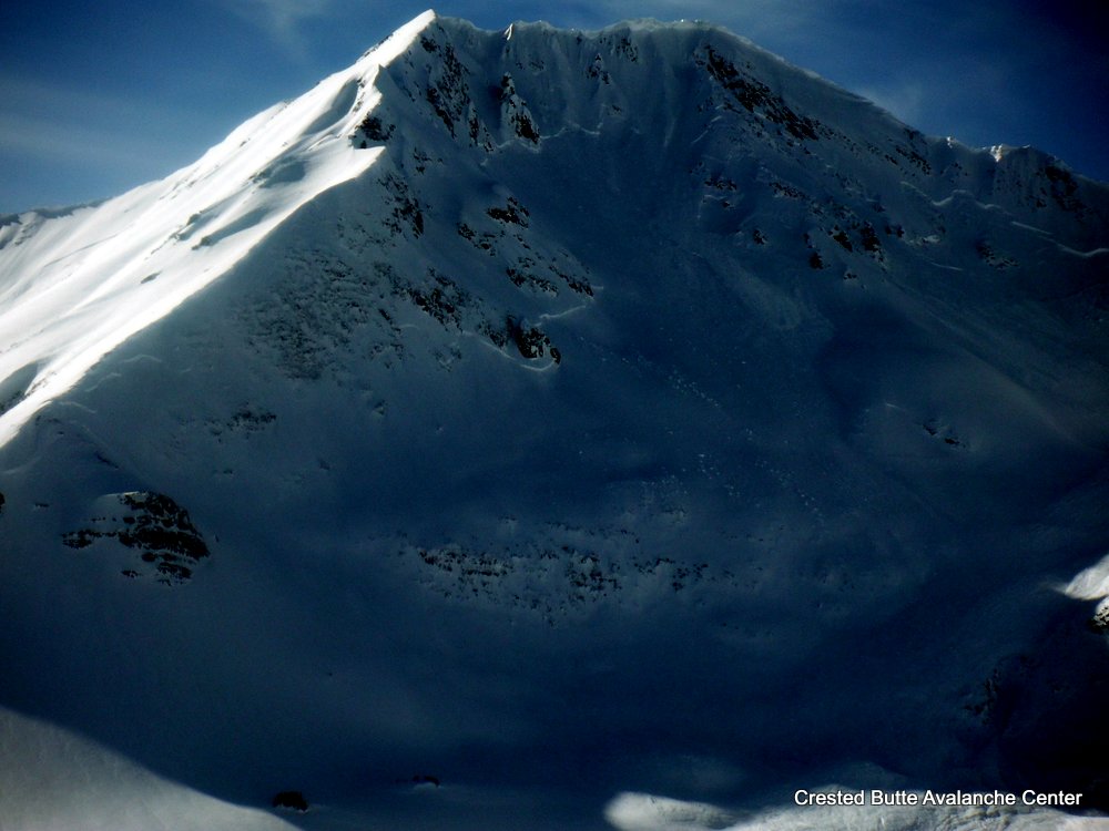
SUBJECT: Avalanche Gothic north bowl
ASPECT: North, North East
ELEVATION: 9,800-12,000


AVALANCHES: Pic of Gothic’s north /northeast bowl that slid down to the river. Not sure when it went but for sure recently. In one pic you can see the outhouse that was covered by the same slide path last winter (13/14). This slide didn’t quite make it that far,

WEATHER:

SNOWPACK:

UPLOADS:

image
image1

Photos from recent avalanche cycle

CBAC2014-15 Observations


Photos by Zach Guy

Snow cat triggered slides above the Nordic CenterDSCF5669-001

Fresh windslabs that ran yesterday or last night on the SE face of Mt. Owen

DSCF5672-001

Northwest Bowl in the Anthracites, ran wall to wall

DSCF5675-001

Southeast face of Mt. Afley

DSCF5678-001


East to Northeast face of Mt. Owen.  I think the looker’s right half ran yesterday or last night, the looker’s left ran earlier in the storm.  DSCF5680-001

Mountain Weather March 5, 2015

CB Avalanche CenterWeather

Date: 03/05/2015

Most weather stations are hovering at or below zero this morning. As a high pressure ridge builds over the west coast, we will see dry northwest flow set up for the next 7 days or so. This pattern brings a gradual warming trend under mostly clear skies and mild winds.

Gothic Update

CBAC2014-15 Observations

Only light to moderate wind Tuesday by mid day with light snow picking up at sunset last night.  The 24 hour totals are 8″ new snow with 0.55″ water as snowpack reached 59½”, now at 59″.  Cloudy  currently with thankfully no wind and cooler at 10ºF.  Flat light and little visibility so nothing new on slides to report but run-out zones show nothing new that i can tell.  billy

Crested Butte Area

CBAC2014-15 Observations

GUIDE: JB 

DATE: 201500304
LOCATION: CB Zone
ELEV: 9,400-10,600
ASPECT: S-SW
WEATHER:   SCT to BKN,  winds moderate gusting to strong  BTL & NTL fom NW
Strong winds kicked up ~1:30 & blew in AM skin track in the open fields.  little drifting in forest.
AVALANCHE / SNOWPACK OBS:
Good views of in-numerable slides on E -NE, around long lake, climax chutes, etc
2 collapses in open meadow (S slope @ 27* & 9,500ft)  where the melt freeze crust from mid storm warm up ~20cm down is 1F (4cm thick) over Fist layer.  HS 45cm
1 collapse SW slope @15* & 10,600ft) Similar structure but crust is thinner ) & only 4F.  HS 70cm
Tests @ 10,400 SW 10* slope angle 30*  HS 55cm   Structure: 50cm storm snow sitting on 5cm mfrc (moist poly crystals)
CTM (11) SC 25cm down on 4F mfcr
ECTN (11)  ”     “
ECTN (11)  ”     “
Ski pen 15-25cm

Natural avalanches viewed from Scarp Ridge

CB Avalanche Center2014-15 Observations

LOCATION: Kebler Pass Area
DATE OF OBSERVATION: 03/04/2015
NAME: Zach Guy
SUBJECT: Natural avalanches viewed from Scarp Ridge
ASPECT:
ELEVATION: various


AVALANCHES: We spotted large slides on all aspects, ranging from D2 to D3 in size. Mt. Gothic’s west face and Mt. Afley’s southeast face both produced impressively wide slides (R4). All of Northwest Bowl in the Anthracites ran (R4). The east face of Ruby and north face of Carbon produced large slides. The south side of Peeler Peak had a couple smaller crowns. All of these slides looked fresh in the past 24 hours. Older debris piles from days prior could be seen from slides originating off of Scarp Ridge’s NE slopes and off of Mt. Owen’s east face. Mt. Axtell’s First Bowl ran sometime today, clearing out a swath of small trees on its way to running full track across Coal Creek.

WEATHER: Brief clearing allowed views across the range.
Snow transport picked up in the afternoon under WNW winds and light snowfall. Cold temps. Broken to overcast skies.

SNOWPACK: 13″ overnight.

UPLOADS:

South face of Peeler Peak

DSCF5664-001

East face of Ruby Peak

DSCF5665-001

Fresh debris this evening with snapped trees below Axtell’s First Bowl

DSCF5667-001

Mountain Weather March 4, 2015

CB Avalanche CenterWeather

Date: 03/04/2015

Moisture erodes quickly as north flow fills in behind the exiting trough. A few light showers may linger this morning, and skies will start clearing this afternoon. The familiar west coast ridge amplifies, bringing dry northwest flow under a warming trend into next week. It has been a great storm, hasn’t it?

Mt. Emmons

CBAC2014-15 Observations

GUIDE(S): JSJ

DATE: 3.3.15

ACTIVITY: BC Skiing
LOCATION: Emmons
ELEVATION: 9,100 – 11,600′ 
ASPECT: NE / E / SE / S
WEATHER: All over the place. Ski was anywhere from obscured and snowing S2 to sunny broken spells. Mod-strong winds at treeline transporting snow from the West. 
SNOWPACK / AVALANCHE OBS: 65cms of settled storm snow from past 2 weeks resting on the old MF crust on sunny solar aspects. Overall storm snow is F-4F hard and near and above treeline is drifted into thick, dense, heavy windslabs. Lots of evidence of recent avalanche activity in past 24-48 hours, with many paths now filling back in with current strong WSW winds. Recent natural avalanches observed on steep lee East terrain of Emmons (D1-D2) and filling back in. Recent crowns and slides were also noted in Coon basin on steep S and E aspects exposed to wind loading (D2). Ran full track to basin bottom and already filling back in and forming new cornices in start zones. Many fresh slab avalanches noted on steep rocky shallow slopes below Whetstone on drive into town on HWY 135 this am also.