Mt. Emmons

CBAC2014-15 Observations

NAME: Evan Ross
DATE: 3/11/15
LOCATION: Mt. Emmons
ELEVATION: 12,000-9,000
ASPECT: N
WEATHER: Thin overcast Clouds created a very warm greenhouse effect below ridgeline where there was no wind. At ridgeling winds where SW light with moderate gusts during the first half of the day.
SNOWPACK:
On north facing upper elevations (ATL/NTL) boot pen averaged about 20cm. HS was around 150cm-195cm on average. Feeling with a probe through the terrain, the PS structure was about 80cm thick with a relatively thin layer of weaker snow below. At these elevations the snow surface stayed dry despite the warm conditions. At lower elevations (BTL) snow surfaces where moist. No obvious or resent sings to instability noticed at all elevations.
ATL snow surfaces on South where still frozen at noon.

Mountain Weather March 11, 2015

CB Avalanche CenterWeather

Date: 3/11/15

Another balmy day is in store for you Vitamin D lovers. High clouds will increase this afternoon ahead of a weak storm pushing across the Great Basin. A cool front aided by afternoon convection could produce some spotty showers tomorrow afternoon into Friday, without much for accumulations. High pressure returns for the weekend.

Mountain Weather for Tuesday, March 10th, 2015

CB Avalanche CenterWeather

Date: 03/10/2015

Temperatures range from the low teens to 20s this morning, and light northwest winds blow at ridge top, as another day of tranquil spring-like weather is on tap again today. Temperatures will climb a few degrees higher than yesterday, with some convective cumulus forming this afternoon. A small, weakening weather system will spread over the area Thursday, but minimal snow accumulations are expected. High pressure re-establishes itself for the weekend and beyond.

Red Lady Bowl

CB Avalanche Center2014-15 Observations

LOCATION: Crested Butte Area
DATE OF OBSERVATION: 03/09/2015
SUBJECT: Red Lady Bowl
ASPECT: South East
ELEVATION: ATL-NTL-BTL


AVALANCHES: No new avalanches or signs of instability observed

WEATHER: Clear skies, light wind on summit

SNOWPACK: The snow was surprisingly cold (and not soft) at 2:30 PM. Thin to moderate crusts were prevalent until low in the bowl and the only moist/soft snow was found on the southern-most slopes below treeline.

UPLOADS:

Snodgrass Observation

CBAC2014-15 Observations

NAME: Evan Ross
DATE: 3/9/15
LOCATION: Snodgrass
ELEVATION: BTL 
ASPECT: NE
WEATHER: Mostly clear, real warm again and no wind.
SNOWPACK:
Persistent slab structure is really scary in many places, yet we didn’t feel a single collapse traveling on a variety of slope angles and terrain features. Where the HS is deep, over 150cm say, the facets below the slab have more resistance and better bonding with one another. Where the HS is shallower the facets below the slab are fist hard and full sugar. Boot pen around 20-30cm on all slopes.
AVALANCHE OBS: 
All kinds of old carnage on this side of snodgrass. Most of the terrain over 35 degrees has already avalanched, but there are still a few pockets left.

Mountain Weather March 9, 2015

CB Avalanche CenterWeather

Date: 03/09/2015

Today is going to be clear, sunny and warm. Some states are having their spring break right now and if they’re in Colorado they’re going to love the weather as high temps increase each day as we head into the weak. For us powder starved CB peeps, we’ll have to wait until another week to get our fix. Chances of snow increase on Thursday and Friday but right now the storm doesn’t look to impressive.

Washington Gultch

CBAC2014-15 Observations

NAME: KristaDATE: 2015.03.08ACTIVITY: Avy 1 ClassLOCATION: Coney’sASPECT: NE

WEATHER: Mostly clear, mostly warm, only a little breezeAVALANCHE/SNOWPACK OBS: Avy 1 class toured up a less than 30 degree north facing slope from 9500 – 11,000ft. 140cm (+/-) snow depth, with a distinct strong over weak snow pack was felt throughout the tour. No signs of instabilities were felt under foot today, however the class was amazed with the amount of avalanches that were visible (literally everywhere) from their ridge top tour. Skiing quality was supportive, penetrating only 20 cm into the snowpack, and no crusts were felt on the north aspects. A new sun crust was forming on the lower angle terrain however, where the sun was affecting the surface of the snow.

Slate River, Paradise Divide

CB Avalanche Center2014-15 Observations

LOCATION: Kebler Pass Area
DATE OF OBSERVATION: 03/08/2015
NAME: Evan Ross
SUBJECT: Slate River, Paradise Divide
ASPECT: E-NE
ELEVATION: Near Treeline


WEATHER: Few clouds, warm temps, no wind.

SNOWPACK: The Slate River valley looks like a war zone and is an absolutely amazing sight seeing tour for an avalanche geek. Just about every piece of avalanche terrain faceting east or north avalanched during the last cycle. All the way from the Happy Chutes to Pittsburgh. There where many paths that ran, that I’ve never seen run before in the last 5 years. There were small pocket slides, too wide crowns extending for a couple thousand feet, too paths running full track into the valley.

Traveled near treeline and nearly found no signs to instability. One fact that could skew these findings is that fact that we had a hard time finding slopes that didn’t avalanche at some point during the recent cycle. I dug two crown profiles along the way with vary different findings and snowapck structure due to their HS.

1st crown profile at an elevation of 10,900ft on a NE facing slope, HS 263cm. Crown was 90cm tall, failing on squashed 1mm FCxr and 1f- hard. CT and DT tests produced no results on this interface.

2nd Crown profile was at ridgeline, elevation 11,600ft, NE facing slope, HS 138. Crown was 85cm tall, failing on 2mm FC and 4f- hard. ECTP-SC 31 with the whole black popping into the pit on a 31 degree slope.

Take home point: The snowpack felt good and stable where the old snowpack was deep before last weeks large storm. The snowpack was concerning and down right scary where the old snowpack was shallow before last weeks storm.

UPLOADS:

Handcock Peak. Crowns visible on NE and E aspects

IMG_0284

Garfield Peak. Wide crowns through the whole ATL north facing basin and in NTL open paths below.

IMG_0283

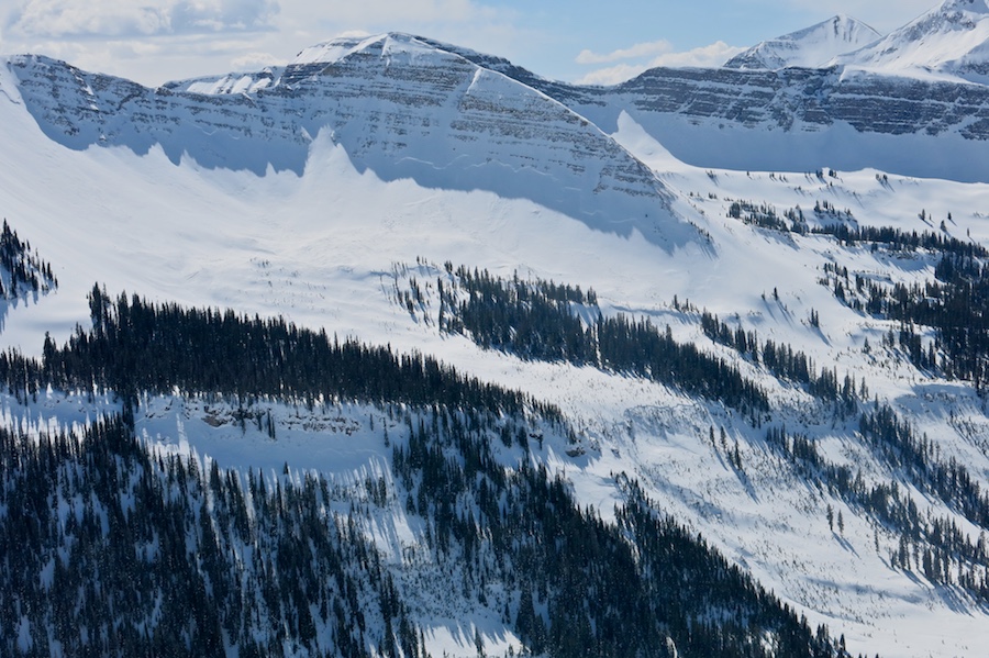
Large Crowns on MT Owen’s NE face

IMG_0282

Schuylkill area is litterd with crowns on ENE facing slopes NTL/BTL

IMG_0272

Mountain Weather March 8, 2015

CB Avalanche CenterWeather

Date: 03/08/2015

You can keep those bikinis and banana hammocks in the drawer today, as spring break weather will be on hold. A small shortwave will force its way over the high pressure ridge this afternoon bringing increased clouds and slightly cooler day time high temperatures. If we see an unlikely flurry of snow out of this system, then I’m going to go buy a lottery ticket. Monday will be the return to spring break with above freezing high temperatures and clear sky as we head into the new week.

Washington Gulch

CBAC2014-15 Observations

NAME: JSJ, KRISTA

DATE: 2015.03.07

LOCATION: Wash Gulch

ELEV: 9,100-10,500′

ASPECT: N-NE

WEATHER:   Clear, sunny, warm, no wind
AVALANCHE / SNOWPACK OBS: Found ~55cms storm snow (F-4F hard) overlying a distinct surface hoar/buried surface layer on top of 100+cms of mostly 4F hard facets. Two large collapses observed on slope of 34* N slope in dark timber with weight of entire group on slope to produce it. Also saw lots of evidence of recent cracking displacing the storm slab on small steep terrain features, but nothing moved despite the slope angle, guessing compressive support on these small slopes was enough to hold it up in shear strength. A test snow profile revealed CTE & CTM on a layer about 25cms above the ground (or 125cms down !). Sudden Planar failure character on both. Also Tilt Test produced very easy failure results with Sudden Planar fracture character results on a layer 10cms below the surface w/i the storm snow, but no evidence of any activity on this layer anywhere in observed recent activity out in the hills.