Date of Observation: 01/30/2016
Name: Jimmy Buchanan
Aspect: North East
Elevation: 9,800′
Avalanches: None
Weather: Overcast, intermittent periods of light precip.
Snowpack: See profile
Date: 01/30/2016
A deep plume of moisture is stretched this morning from the Hawaii Islands into Colorado, packing pineapples, hula dancers, and significant snowfall for the Elk Mountains this weekend. The initial warm phase of this storm is under-performing thus far, with no new snow as of 5 a.m. An impressive band of precipitation is stretched across I-80 from San Francisco to Salt Lake City on the radar this morning. We’ll see dynamic support improve towards the latter half of the day as the jet stream sags over Colorado, and that is when the first big flakes should fly, along with increased wind speeds. The best forcing and heaviest snowfall arrive as the cold front pushes through after sunset. A deepening low moves towards the Four Corners on Sunday, with good atmospheric lift, fueling additional snowfall into early next week.
High Temperature: 25
Wind Speed: 15-25, G45
Wind Direction: SW, W
Sky Cover: Overcast
Snow: 2-5″
Low Temperature: 10
Wind Speed: 10-20, G40
Wind Direction: E, W
Sky Cover: Overcast
Snow: 10-14″
High Temperature: 18
Wind Speed: 5-15
Wind Direction: SW, W
Sky Cover: Overcast
Snow: 2-4″
Avalanches:
Weather: Strong north winds in valley bottom and observed on ridge tops in morning. Apron. 1” new snow overnight, no precip during day – mostly clear skies with high, thin clouds developing in late afternoon. Temps in 20s most of the day.
Snowpack: Full-depth facets on north side of Snodgrass. HS of 80cm (ish) with knee-deep skiing on steeper terrain and boot top deep skiing on shallower terrain. No signs of instabilities, except for a couple, extremely small wind slabs (like the size of a mini-fridge) right at the ridge. No significant facet sloughing.
Avalanches: Touchy, very small windslabs running on crust 6-10 cm deep on freshly wind loaded SE aspects
Weather: Overcast cleared to scattered skies by mid day. Moderate SW winds with strong gusts and moderate snow transport, working over snow surfaces on windward slopes.
Snowpack: 5cm of new this morning, not bonding well to Jan 29 crust. On SE aspect ATL, this crust was 4-8cm thick with 1mm facets below it. On WSW aspect BTL, there were 2 crust layers near the surface, 2 cm thick, with 1-2 cm of fist hard faceting DF’s (.5mm) between and 0.5mm DF’s below the crusts. Jan 14th rounding facet layer was 55 cm deep, with CT12, SC results.
Avalanches:
Weather: Clear, Calm, Hot (high of 36F observed) w/ strong solar.
Snowpack: Widespread surface hoar up to 6mm on protected slopes. Broken down some by sun on lower angle slopes by afternoon, but still prevalent and 2-3mm in size. The surface snow continues to facet and weaken and lose strength and cohesion where HS is < 1.5M. Ski Pen mid calf deep; Boot Pen bottomless. No instabilities noted.
Date: 01/29/2016
A shortwave disturbance will bring a few flurries today, in advance of strong zonal flow setting up this weekend. The jet stream, laden with deep moisture, noses south across Colorado on Saturday. Flow will be out of the west-southwest, which is a favorable direction for pushing heavy snowfall across most of our forecast zone. Models continue to remain optimistic on this weekend’s storm, but aren’t coming into agreement on how big just yet. Snowfall starts in earnest around midnight tonight, with the heaviest pulse looking to crank out significant snowfall from about noon into midnight on Saturday. Look for 12” to 24” to accumulate before a lull on Sunday morning. Another pulse arrives Sunday evening. A deepening trough develops by Monday, driving continued snowy weather under less-favorable southwest flow into early next week.
High Temperature: 32
Wind Speed: 5-15
Wind Direction: W
Sky Cover: Overcast
Snow: 0-1″
Low Temperature: 18
Wind Speed: 10-20
Wind Direction: SW, W
Sky Cover: Overcast
Snow: 3-5″
High Temperature: 30
Wind Speed: 15-25, G45
Wind Direction: SW, W
Sky Cover: Overcast
Snow: 5-8″
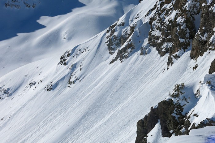
Avalanches: Lots of rollerballs and a few small wet loose from yesterday on steep SE, S, SW aspects N/ATL. A few more rollerballs today. Spotted two more old crowns from 1/20 – 1/21 cycle on SE aspects above treeline.
Weather: Clear, calm winds, warm temperatures
Snowpack: See photo captions. Surfaces have very small near surface facets on both north and south aspects. Large surface hoar below treeline in places. No signs of instability other than rollerballs.

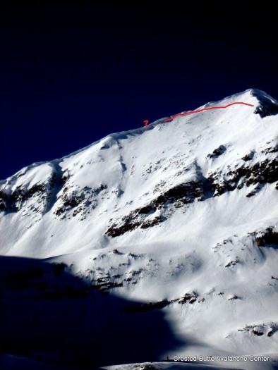
Old crown likely from 1/20-1/21 cycle. SE aspect of Afley Peak. This one ran during Christmas cycle as well.

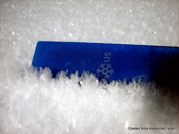
Large surface hoar in wind-sheltered, low elevation, shaded slopes.

Northerly aspects ATL hold a mix of Fist hard, soft rippled DF’s and 4F hard wind crusts. All have a very thin layer (<2mm thick) of .5mm near surface facets above.

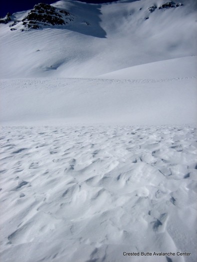
Rollerballs on southerly aspects

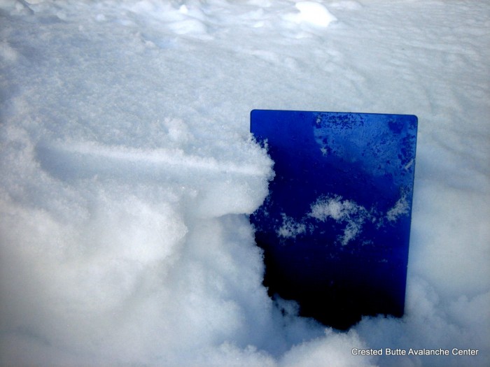
Steep S/SE aspects ATL have a new crust, 2-4cm thick, with small grained (.5-1mm) radiation re-crystallization facets above. The facet layer was 1cm thick this morning above the crust, but it looked to have cooked upwards through the day leaving a 1-2 mm thick layer of facets on the surface by sunset. Below the crust is moist to dry DF’s down the the Jan 24th crust, which was about 5 cm thick and 25-30 cm deep.

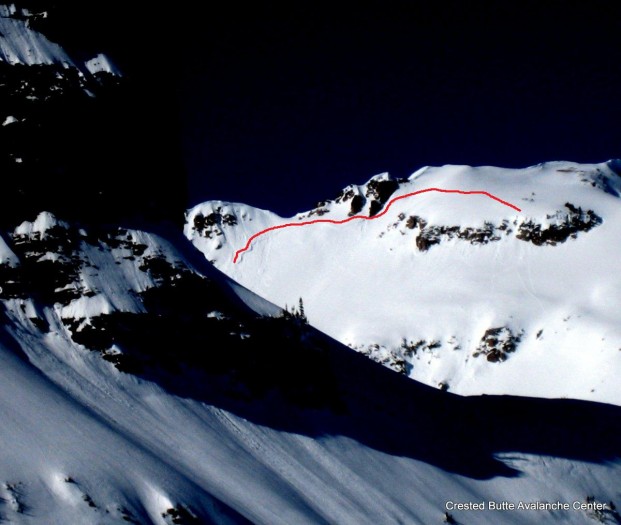
Old crown likely from 1/20-1/21 cycle. SE aspect of Oh-Be-Joyful Peak.
Avalanches: Lots of roller balls and over a dozen small wet loose avalanches observed today off of steep rocky Southerly terrain.
Weather: WEATHER: Mostly clear, some high clouds, increasing NW winds in afternoon, strong solar.
Snowpack: SNOWPACK/AVALANCHE OBS: Surface snow continues to facet and weaken on shady aspects. Solar slopes BTL & NTL got moist in the afternoon, low angle solar slopes stayed dry. Overall HS averaged 100-140cm. One small skier triggered crack observed on a steep rollover below some exposed rocks. Didn’t propagate very far and stayed in the surface instabilities.
Avalanches:
Weather: WEATHER: Few Clouds, noticeable inversion
10am T Surf: -13c T20: -11c
2pm Tsurf: -10.7c Air: -9c
Snowpack: Widespread surface hoar from the TH to the top of Coneys. The sun cut it down mostly throughout the day but some is still preserved in the shady spots. Hs varied from 110-120cm throughout coney bowl. No signs of instabilities. Ski pen: 19cm Boot pen: 40cm
Date: 01/28/2016
We’ll see some high level clouds move overhead today under warm mountain temperatures as the high pressure ridge flattens and moves east. Several weak disturbances tonight and tomorrow will bring a chance for light flurries. The jet stream, loaded with moisture from the Pacific, shifts south over Colorado on Friday night into Saturday. This should bring heavy snowfall to our mountains through Monday. We’ll get a better picture as the storm gets closer, but early model runs are hinting at storm totals reaching near or exceeding 2 feet by the end of the weekend.
High Temperature: 35
Wind Speed: 5-15
Wind Direction: W, NW
Sky Cover: Mostly Clear
Snow: 0
Low Temperature: 10
Wind Speed: 5-15
Wind Direction: W
Sky Cover: Partly Cloudy
Snow: 0
High Temperature: 32
Wind Speed: 5-15
Wind Direction: W
Sky Cover: Mostly Cloudy
Snow: 0-1″