


No storm instabilities but propagating persistent slab results
Location: Paradise Divide Area
Date of Observation: 03/24/2016
Name: Zach Guy
Date of Observation: 03/24/2016
Name: Zach Guy
Subject: No storm instabilities but propagating persistent slab results
Aspect: North East
Elevation: 9,300-10,700
Aspect: North East
Elevation: 9,300-10,700
Avalanches: No recent avalanches observed from Slate River Road, with good views of Emmons and Schuylkill Ridge
Weather: Scattered clouds, mild temps, calm winds, pulse of S1 near sunset.
Snowpack: 25-30 cm of settled storm snow over a dust layer, well bonded to old interface, with no fractures in stability tests and no signs of instability on steep rollovers. Minimal signs of windloading in this area. Snow surface had moistened earlier in the day and was refreezing into a breakable crust on pitches with a ENE tilt.
One profile on a due north slope BTL showed the March 6 facet layer had gained significant strength since my profile in the same area last week. Hard ECTN results and Q2 fractures in compression tests on this layer, Near treeline on a NE aspect, the same layer was above a very thin melt-freeze crust, and below 80cm of 1F slab. We got repeatable hard ECTP Q1 results on this layer (see video).
Sluffing
Location: Paradise Divide Area
Date of Observation: 03/23/2016
Name:
Date of Observation: 03/23/2016
Name:
Subject:
Aspect: North
Elevation: 11,000
Aspect: North
Elevation: 11,000
Avalanches: New snow in steep and protected N facing trees was sluffing fast and heavy with every turn, leaving debris piles 3-5′ deep on flat benches. No propagation.
Weather: Snow of varying intensity and gusty winds out of the NW
Snowpack:
anthracites avy activity
Location: Kebler Pass Area
Date of Observation: 03/23/2016
Name: MR
Date of Observation: 03/23/2016
Name: MR
Subject: anthracites avy activity
Aspect: North, North East
Elevation:
Aspect: North, North East
Elevation:
Avalanches: skier triggered r2d1 in rock chute, looks like it was triggered by a ski cut on the first convexity, new snow fracturing like a slab and running full width and about half of the length of the chute. We triggered any r1d1 pockets that were left on anything 35 degrees or steeper. Also remote triggered r1.5d1 in baby bowl while exiting rock. Blowing snow made it difficult to evaluate depth and location of crown, assuming the same as in rock.
Multiple naturals look to have run mid storm in the trees and openings to skiers left of seven bowl.
Weather: blowing and snowing, wind moving big trees and transporting snow everywhere, including onto the skin track in between laps
Snowpack: 8-12 inches new snow
Mountain Weather
Date: 03/24/2016
A few weak shortwaves embedded in northwest flow today will bring partly cloudy to mostly cloudy skies and generally light winds today. A low pressure trough digs out of the northwest tomorrow. We’ll see increased clouds and moderate winds ahead of this system, and sometime on Friday an unorganized cold front swings through the Elk Mountains, spreading snowfall from the northwest to southeast, with winds easing in its wake but snowfall continuing. Snow numbers into Saturday look to be in the 4-8″ range form Star Pass and 3-6″ range for Taylor Pass, with potential for larger numbers in the favored western portion of our zone.
Today
High Temperature: 30
Wind Speed: 5-15
Wind Direction: W, NW
Sky Cover: Mostly Cloudy
Snow: 0-1″
Tonight
Low Temperature: 15
Wind Speed: 5-15
Wind Direction: W
Sky Cover: Mostly Cloudy
Snow: 0
Tomorrow
High Temperature: 25
Wind Speed: 10-20, G30
Wind Direction: W
Sky Cover: Overcast
Snow: 1-3″
Family pow pow day
Location: Crested Butte Area
Date of Observation: 03/23/2016
Name: Dave and Ross
Date of Observation: 03/23/2016
Name: Dave and Ross
Subject: Family pow pow day
Aspect: North East, East
Elevation: 9,600’-11,300′
Aspect: North East, East
Elevation: 9,600’-11,300′
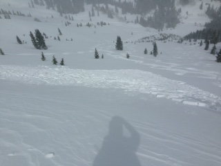
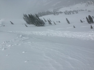
Avalanches: 1x R1/D1, at 11,300ft, skier triggered slab, convex roll, 25cm deep and ran 20m on the melt freeze crust layer prior to the storm. see photos. Snow got moist towards the valley floor.
Weather: Mostly overcast, S1 at best. Wind 20mph from the W
Snowpack: At the trail head 10cm of snow sitting on a melt freeze crust. At 11,300 25cm of new snow.
Big storm totals
Location: Kebler Pass Area
Date of Observation: 03/23/2016
Name: Irwin Guides
Date of Observation: 03/23/2016
Name: Irwin Guides
Subject: Big storm totals
Aspect: East, South, West
Elevation: 10-12,000 ft
Aspect: East, South, West
Elevation: 10-12,000 ft
Avalanches: Some instabilities with 30-50cm storm/wind slabs skier triggered up to D1.5 on cuts. East aspect ATL Binge: SS-AScr-R1-D1.5-S This was triggered 15’ remotely, while setting a right hand boundary in Jaybirds while putting a hard turn in just below ridge line. 50cm’s deep, 100’ wide, ran 500’. It ran in the storm snow 20cm’s above the crust.
Weather: S5 all day with some sunny beaks poking through, though never blue. Moderate SW winds gusting to 50 mph. Highs of 23°/12°. 11” new snow throughout the day.
Snowpack: 27 inches w/ 1.35″ SWE in 20 hours. HST 24″, HS: 82″. Still snowing S2 a 17:00. Mostly blower, light density snow (5% this morning). Southerly aspects up high got thicker with sun and wind. East had deeper wind slabs.
Dusk on Snodgrass
Location: Crested Butte Area
Date of Observation: 03/23/2016
Name: ADB
Date of Observation: 03/23/2016
Name: ADB
Subject: Dusk on Snodgrass
Aspect:
Elevation: BTL
Aspect:
Elevation: BTL
Avalanches:
Weather: S-1, light winds, obsscured sky with hints of blue
Snowpack: Less than 5 cm of new snow within 24 hours on sun crust.
1″ overnight
Location: Brush Creek Area
Date of Observation: 03/23/2016
Name: Friends Hut Field Team
Date of Observation: 03/23/2016
Name: Friends Hut Field Team
Subject: 1″ overnight
Aspect:
Elevation: Near treeline
Aspect:
Elevation: Near treeline
Avalanches:
Weather:
Snowpack: 1″ of accumulation overnight at Friends Hut
Windy, Soft and Crusty
Location: Crested Butte Area
Date of Observation: 03/22/2016
Name: WN
Date of Observation: 03/22/2016
Name: WN
Subject: Windy, Soft and Crusty
Aspect: North East, East
Elevation: 9,600’-11,300′
Aspect: North East, East
Elevation: 9,600’-11,300′
Avalanches:
Weather: Overcast, Cold, Mostly mod winds with pulses of strong gusts out of the S-SW.
Snowpack: The snows surfaces today varied from sun/MF crust (E aspect) to dry wind affected powder (NE Aspect). Hand shears showed old storm snow was bonding well with old interface, results also showed the slab popping out as a FF slab when applying pressure with hand on 1mm facets.