Natural avalanches ATL

CB Avalanche Center2016-17 Observations

Location: Brush Creek Area
Date of Observation: 03/01/2017
Name: Zach Guy
Subject: Natural avalanches ATL
Aspect: North East, East, South East
Elevation: 9,300-12,800

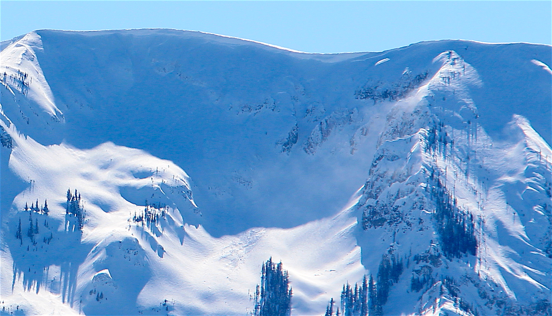
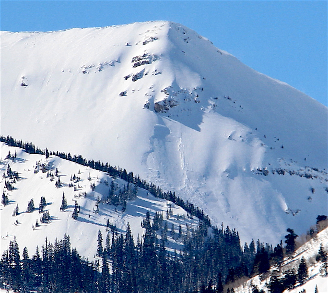
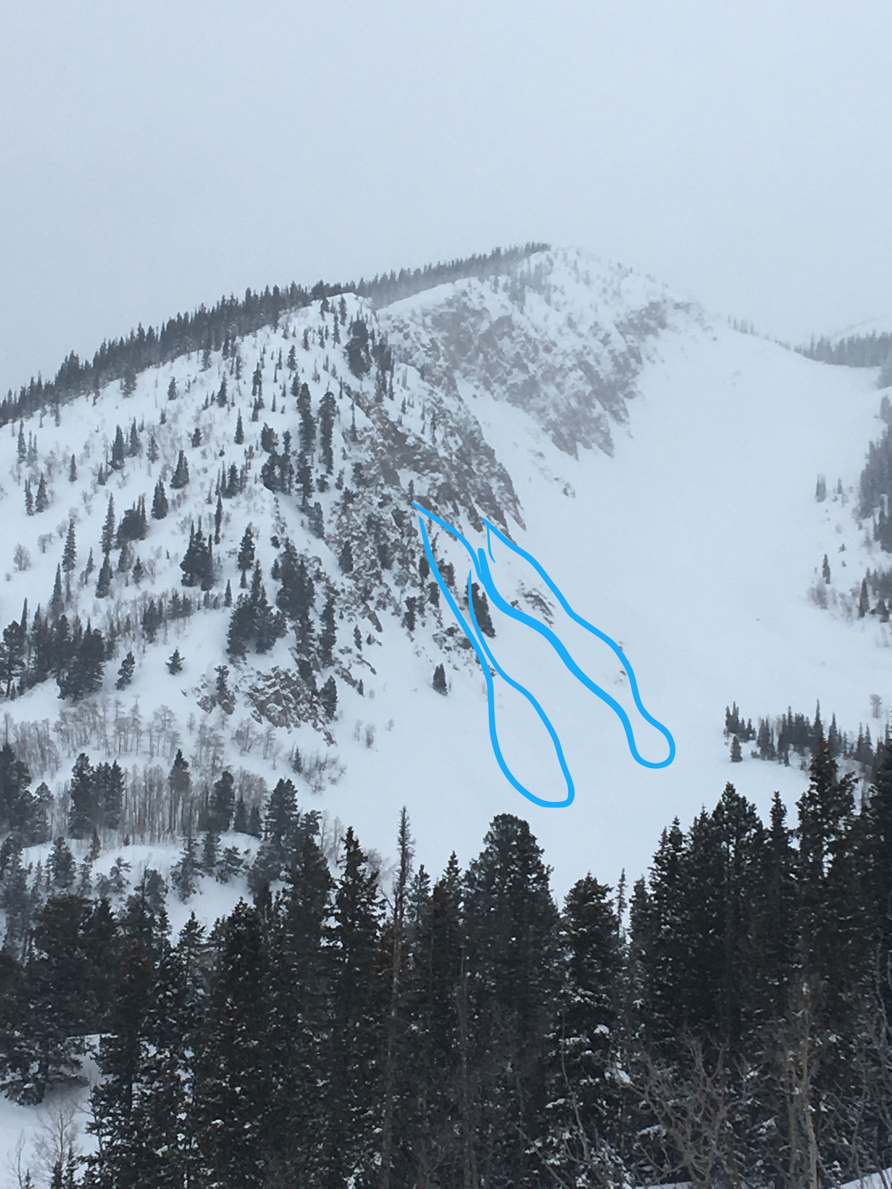
Avalanches: Numerous natural D1 to D2 soft slab avalanches, mostly on easterly aspects above treeline (NE to SE). Based on crown thicknesses and snow structure obs, I assume that most of these failed on the crust/facet layers buried about 18-24″ thick. There were also a few D1 shallow wind slabs. See photos.
Weather: Cold, clear, light winds with no transport.
Snowpack: Below treeline, 12-18″ of soft slab down to the concerning persistent weak layers (crusts/facets).
Above treeline, highly variable slab thickness and distribution due to westerly winds. Most westerly aspects are scoured away. One crown profile on an ESE aspect showed 20″ of F to 4F slab over a thin melt-freeze crust with 1-2mm facets above and below. Extended column failed on isolation (ECTPV, SC).

D2 NE aspect NTL. X Chutes on Whetstone. Ran a long way.

D2 E aspect near White Rock Mountain.

D2 E aspect ATL. Near White Rock Mtn

2xD1.5 NE aspect Double Top

D1.5 NE aspect Double Top

ECTPV on 1-2mm facets below a 1 cm MFcr, 50 cm deep. ESE aspect ATL.

D2. SE aspect Hunter Hill

D1.5 SE aspect Hunter Hill

D2. NE aspect Double Top.

D1.5 E aspect Hunter Hill

D2. SE aspect Timbered Hill

D1.5/D2’s. E and NE aspects above West Brush Creek

D2. N aspect ATL. Lambertsons Peak

D1.5 East aspect ATL. Hunter Hill

D1 windslab. E aspect, Star Pass.

D2. NE aspect ATL. Carbonate Hill
Reactive persistent slabs and sluffs

CB Avalanche Center2016-17 Observations

Location: Brush Creek Area
Date of Observation: 02/28/2017
Name: Zach Guy
Subject: Reactive persistent slabs and sluffs
Aspect: East, South East
Elevation: 10600-11600

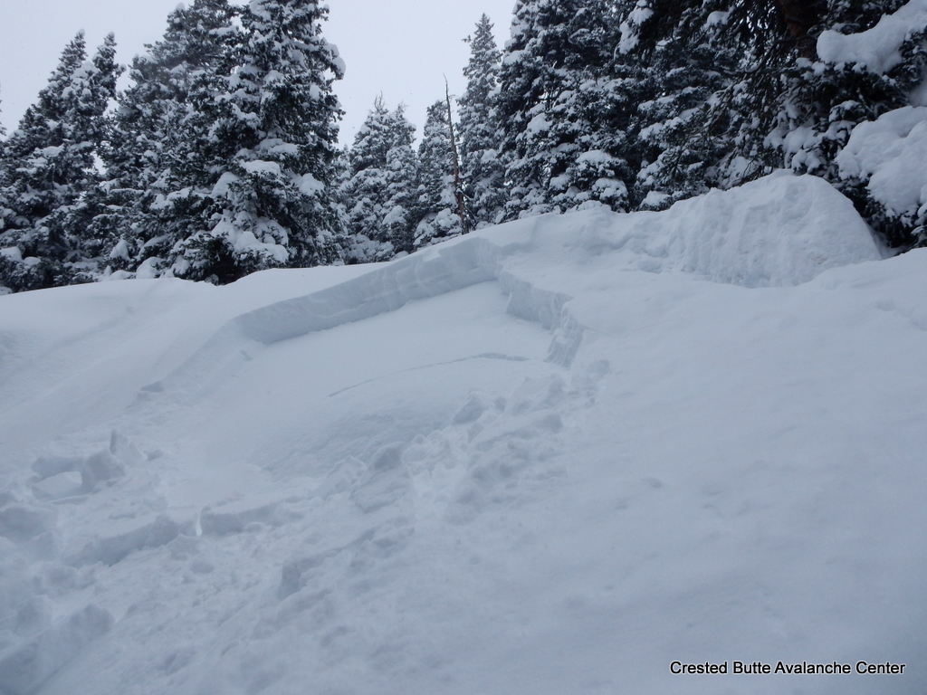
Avalanches: Skier triggered numerous loose snow avalanches in the top 12″ of the storm snow, up to D1.5 in size. Remotely triggered a small rollover from below, failed about 20″ deep on the 2/17 facet layer. SS-ASr-R1-D1-O. Poor vis, no other avalanche observations.
Weather: S-1, Overcast to broken skies, winds increased through the day, becoming strong and transporting lots of snow.
Snowpack: 18″ of storm snow at Friends Hut. The top 12″ came in very low density (~3%). Widespread loose snow instabilities, but the storm snow became slabbier through the day due to settlement and wind affect. Persistent weak layers (near surface facets and thin crust/facets) were reactive: multiple moderate collapses, a 100′ shooting crack, and remote triggered a small pocket, all on buried facets about 18-24″ deep. The most concerning structures were on ESE and E aspects, where there are thin crusts surrounded by facets.

DSCN2095-001

Avalanches on Easterly Aspects Throughout the Zone

CB Avalanche Center2016-17 Observations

Location: Crested Butte Area
Date of Observation: 03/01/2017
Name: Arden Feldman
Subject: Avalanches on Easterly Aspects Throughout the Zone
Aspect: North East, East, South East
Elevation: ATL, NTL, BTL

Avalanches: Many natural D1-D2 soft slabs on northeasterly and easterly ATL/NTL slopes. One natural D2.5 slab on a southeasterly/easterly aspect of Mt. Bellview. One natural D1 storm slab BTL on an east aspect. Skier triggered a D1.5 storm slab yesterday (2/28), on a steep northeasterly slope NTL.

See email for pictures
Weather: Clear skies with light winds and warming temps. Some snow blowing off the high peaks.
Snowpack:

Mountain Weather 3/1/2017

CB Avalanche CenterWeather

Date: 03/01/2017

Temperatures bottomed out in the single digits below zero this morning, and will struggle to break the upper teens as clouds linger and limit daytime heating across higher terrain favored by residual northwest flow.  Yesterday’s storm system has moved eastward, and aside from the higher peaks, we will see generally sunny skies for most of the forecast area.  Moderate west winds will drop off this morning, leaving forgivingly light winds to treat those able to enjoy the backcountry today.  Looking ahead, sunshine and a gradual warming trend will bring us into the weekend.  The next potential for a shot of snowfall looks like Sunday, but accumulations look light at this point.

7am Gothic Townsite Snow Obs

CB Avalanche Center2016-17 Observations

Location: Crested Butte Area
Date of Observation: 02/28/2017
Name: billy barr
Subject: 7am Gothic Townsite Snow Obs
Aspect:
Elevation: 9300

Avalanches:
Weather: Here are the 24 hour totals (earlier I gave only overnight). There was 8 1/2″ new with water 0.77″ and snowpack now at 90″. Snow has become light and temp. holding at 19F. No visibility. I am tired. billy
Snowpack:

Upper East River Basin/Gothic

CB Avalanche Center2016-17 Observations

Location: Crested Butte Area
Date of Observation: 02/28/2017
Name: Steve Banks/Mike Soucy
Subject: Upper East River Basin/Gothic
Aspect: North East, East, South East, South, South West
Elevation: 9000-11100

Avalanches: About 10″ of new snow since yesterday morning. Lots of small, localized collapses underfoot throughout the day on all aspects travelled on. 1 test profile showed HS 230 cm with 35 cms of newer snow over crust facet sandwich. ECTX but prying with the shovel popped the slab off on 1cm thick .5 mm facets between 2 crusts.
Remote triggered a D2 and a small D1 on the NE slopes of Snodgrass skiers left of the low point of the saddle. Triggered from a small bench about 200′ away from the slope. 200′ wide running about 600 vertical with a crown of up to 53 cms. Weak layer was buried near surface facets. 35 degree slope at 10,400′ Crown investigation showed CT 21 SP failing on the same NSF.
Also noted a large D2.5 off of the East face of Gothic initiating just below the very large cornice on the summit ridge and running to about 10,200 just above the valley floor.
Watched a release out of very steep terrain, East facing above Copper Creek likely windslab and maybe D2. Noticed 2 other pockets, mid elevation roughly 10,600 with minimal propagation and D 1.5.
Peak of instability seemed to come around 3 pm today. Surface snow became noticeably stiffer in the afternoon.
Weather: S-1 most of the day with periods of S3. Increasing winds through the day as snow decreases with strong gusts in the afternoon. Winds from the West and high temp of -7.
Snowpack:

image3
image4
image5
image2

Irwin Tenure

CB Avalanche Center2016-17 Observations

Location: Kebler Pass Area
Date of Observation: 02/28/2017
Name: Irwin Guides
Subject: Irwin Tenure
Aspect: East, South, West
Elevation: 10,000-12,000

Avalanches: numerous cracking and shallow windslabs. one natural overnight in Sonic from heavy wind loading, D1, 12″ deep, 30′ wide. Explosive work did not produce significant results, despite large shots (5-12£)
Weather: Heavy snow at times during morning, gradually tapering after lunch, but still moderate snow showers. West winds 20 G60, especially in afternoon, cold temperatures with highs at ridge barely reaching 10Âo and temps at 10k topping out at 19Âo.
Snowpack: Storm total as of 1500 sits at 18″ with 1.5″ SWE. 9% density overnight, with slightly lighter snow today, created widespread slow stuffing in terrain steeper than 33AÌ‚o, shallow windslabs developing with ideal westerly winds blowing 20 G 50. New snow is variable across terrain due to wind, some places scoured to crust, others 3ft deep. BTL, snow is uniform and deep, with ski pen 30-40cm.

photo on drive down Kebler of North facing Coal Creek.  Suspected surface hoar near creek bottom.  notice no fracture very close to trees, no surface hoar development there due to constant longwave radiation.

5am Gothic Townsite Snow Obs

CB Avalanche Center2016-17 Observations

Location: Crested Butte Area
Date of Observation: 02/28/2017
Name: billy barr
Subject: 5am Gothic Townsite Snow Obs
Aspect:
Elevation: 9300

Avalanches:
Weather: Strong, steady wind until nearly 3 a.m. with driven, dense snow. Wind becomes light as snow picks up though still dense with 4½” new by 5:30 a.m. and water of 0.53″ (water is from instrumentation not official but probably very close). Snowpack back to 89½”, just 1½” below winters deepest. A nasty night, nasty morning and nasty winter (these views are those of the Gothic weather station and in no way reflect those of the greater CB area- even if they are correct).

Currently moderate snow and light, steady SW wind with obscured cloud cover. Temp. overnight ranging only from 22 to the current 19ºF. billy
Snowpack:

Mountain Weather 2/28/2017

CB Avalanche CenterWeather

Date: 02/28/2017

Snow will continue through much of the day, before tapering off toward sunset. Moderate to strong west winds will continue most the day, before lessening tonight as the jet stream over head moves eastward. Temperatures and windchills will remain bitter, with highs at 11,000ft only reaching the upper teens. Today’s storm will clear out for generally sunny skies the rest of the week, and light northwesterly winds by Wednesday morning and beyond.

Windy Schuylkill Ridge

CB Avalanche Center2016-17 Observations

Location: Crested Butte Area
Date of Observation: 02/27/2017
Name: Travis Colbert
Subject: Windy Schuylkill Ridge
Aspect: North East
Elevation: 11,400

Avalanches: Remotely triggered a cornice break skier’s left side of Yogi’s that triggered a small soft slab avalanche 12+ inches deep. Skier triggered a few small pockets on isolated convexities. Some sloughing, that toward the end of the day was exhibiting almost soft slab-like movement.
Weather: Strong SW wind (30+ mph) and snowing.
Snowpack: 12+ inches of soft, non-cohesive snow becoming noticeably more cohesive over the course of the day. Skied Snakey, Thanksgiving Bowl and Birthday Bowl. Massive cornices along the entire ridge due to several days of strong W & SW winds. Amazing skiing with particular caution at the wind-loaded entrances. Snowfall and winds were increasing as the day progressed, and I expect these slopes to be touchy in the days ahead.