February 10th – 16th: Warm Temperatures with Snow and Low Elevation Rain

CBAC2016 - 17 Weekly Snowpack Summaries, Weekly Snowpack Summaries

By Arden Feldman            CBAC Intern

The week started off balmy on February 10th with warm, moist southwest flow issuing in record high temperatures for the second day in a row. billy barr’s Gothic weather station recorded a record high of 48 degrees. A closed low off of the California coast began streaming unusually warm Pacific moisture into Colorado during the evening of the 10th. This caused increasing clouds and precipitation to filter into the region with strong winds. The freezing level was around 10,000 feet, so downtown Crested Butte and many below tree line slopes received rain, while higher elevations received dense snow. Winds on the 10th averaged 24 mph and gusted up to 89 mph at 11,000 ft. On the evening of the 11th, a cold front passed overhead sparking heavy snowfall and allowing temperatures to finally drop below freezing throughout the forecast area. By the morning of the 12th, 3” of SWE and 19” of snow had accumulated at Schofield Pass, and 14” of snow was reported at CBMR.

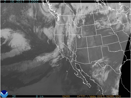
2/11/17 – Satellite image showing the Pacific moisture flowing into Colorado.


On the 12th, the atmospheric flow split around Colorado with the main flow to our north and the cut off low to our south. The low was still sending some leftover moisture into our area with a southerly flow, causing light snow showers.. The flow then began to dry out, beginning a clearing and warming trend through the rest of the week. On the 14th there was a high of 22F at 11,000 ft but by the 16th, there was a high of 44F with beautiful clear skies.

2/16/17 – Satellite image showing clear skies over Colorado.


Persistent slabs on buried surface hoar layers on northerly and easterly aspects remained a problem this week. This week’s storm added a significant new load to the snowpack and tested the persistent weak layers, and we observed a handful of natural avalanches failing on buried surface hoar or facets again. The instabilities became increasingly isolated and stubborn through the week, but they were still present and sadly consequential, resulting in Colorado’s first fatality of the season in the Flat Tops. The storm also resulted in storm slab concerns, but few were reported likely due to the limited visibility during the storm.

2/14/17 – Natural D2 slab avalanche on a northeast aspect of Mt. Axtell.


2/14/17 – Persistent slab avalanche in the Flat Tops zone that resulted in the first avalanche fatality of the season in Colorado.


2/14/16 – Natural slab avalanche on a northeast aspect that appeared to fail on surface hoar.


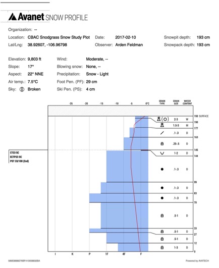
2/10/17 – CBAC Snodgrass Snow Study Plot profile showing the problematic surface hoar layer.


The warm temperatures and low elevation rain during the week resulted in wet avalanche problems. Relatively small but potentially consequential natural (here, here, here) and skier triggered wet loose avalanches were observed throughout the week, and with the rain below tree line, and several wet slab avalanches were also observed.

2/17/17 – Wet loose avalanche cycle on east, south and west aspects.


2/19/17 – D2 wet slab avalanche on a south aspect ATL.

Fresh persistent slab in Red Lady Bowl

CB Avalanche Center2016-17 Observations

Location: Crested Butte and Kebler Pass Areas
Date of Observation: 03/04/2017
Name: Zach Guy
Subject: Fresh persistent slab in Red Lady Bowl
Aspect: South East
Elevation: Near treeline

Avalanches: Fresh slab avalanche in Red Lady Bowl; first noticed the crown early this morning so I assume it was human triggered yesterday. It ran the full width of a relatively small feature mid-track in the bowl (SE aspect NTL), estimated 700 feet wide, 100 vertical, and 2 feet deep. SS-U-R1-D1.5-O
Weather: Strong SW winds. Few clouds. Temps rose into the 30’s.
Snowpack: Surface warming was minimal today on high elevation southerly aspects due to the strong winds, so no wet avalanche concerns where we traveled.

Mountain Weather

CB Avalanche CenterWeather

Date: 03/04/2017

The axis of high pressure passed overhead last night, opening the doors to warmer southwest flow ahead of the next Pacific trough. There is enough high-level moisture for a few thin clouds today, and winds will begin to increase. Tie down your children and small pets tomorrow, winds will be gusting beyond 60 mph as the trough makes landfall. Snowfall will spread into the Elk Mountains by Sunday evening, and we can look forward to a relatively modest refresh by Monday morning, in the 4-8″ range.

Mt. Emmons

CB Avalanche Center2016-17 Observations

Location: Crested Butte Area
Date of Observation: 03/03/2017
Name: Donny
Subject: Mt. Emmons
Aspect: North
Elevation: 9,000’ to 11,400′

Avalanches:
Weather: Clear, calm, and temps that got close to 0ºC.
Snowpack: Avg SkiPen: 10cm – Avg BootPen: 30cm. North aspects stayed cold and dry. Upper 15cm is faceting. No signs of instabilities.

Snodgrass

CB Avalanche Center2016-17 Observations

Location: Crested Butte Area
Date of Observation: 03/03/2017
Name:
Subject: Snodgrass
Aspect: East
Elevation: BTL

Avalanches: Heavy loose snow slides at the bottom of Snodgrass’s 2nd bowl gully. 8″ of non cohesive snow broke loose and slid frequently on the previous windload from the evening before. This was mid day and exposed to sun most of the morning causing some pretty rapid snow changes.
Weather:
Snowpack:

20170303_075137-001

D2 in Evan’s Basin

CB Avalanche Center2016-17 Observations

Location: Kebler Pass Area
Date of Observation: 03/03/2017
Name: Jeff Banks
Subject:
Aspect: East
Elevation: NTL

Avalanches: observed a new D2 east facing, steep ~40* below main ridge (no cornice) snowmobile triggered? tracks at the base. Did not see it yesterday when I spotted these slides pictured below. Here’s shots from the day before & another ~D1.5 that was hard to see
Weather:
Snowpack: Numerous small to medium collapses on windward side of ridge above Indy Basin on low angle terrain

image1
image2

Small wet loose

CB Avalanche Center2016-17 Observations

Location: Kebler Pass Area
Date of Observation: 03/04/2017
Name: Zach Guy
Subject: Small wet loose
Aspect: East, South, West
Elevation: 9,000 – 12,500

Avalanches: Small (D1) wet loose avalanches ran on E, S, and W aspects, all elevations. These all originated from steep, rocky areas and didn’t run very far.
Weather:
Snowpack:

minimal issues BTL SE,E

CB Avalanche Center2016-17 Observations

Location: Crested Butte Area
Date of Observation: 03/03/2017
Name: Evan Ross
Subject: minimal issues BTL SE,E
Aspect: East, South East
Elevation: 9,300’ to 10,600′

Avalanches:
Weather: Clear, calm, strong solar.
Snowpack: On most slopes not much for concerning structure. Either hot-pow over old snow surfaces that could have been pulled out as a loose wet avalanche on steep slopes, or a faceting soft slab on protected east aspects over old snow surfaces. Wind loading on the right slope over some of the weak old snow surfaces would have been key to find a more significant avalanche problem in this area. This snow surfaces will be crusty tomorrow morning before the next round of warming.

Mountain Weather

CB Avalanche CenterWeather

Date: 03/03/2017

My mom called last night to remind everyone to reapply sunscreen through the day. A broad ridge of high pressure will shift east across the Continental U.S. over the weekend. Mountain temperatures will rise from the teens this morning to near freezing under sunny skies and light winds. A Pacific trough moves onshore on Sunday, bringing our next round of snowfall starting Sunday evening.

Schuylkill slides

CB Avalanche Center2016-17 Observations

Location: Paradise Divide Area
Date of Observation: 03/02/2017
Name: Mike Nolan
Subject: Schuylkill slides
Aspect: North East, East
Elevation: NTL

Avalanches: See photos of previous natural avalanche activity
Weather:
Snowpack:

skook2
skook