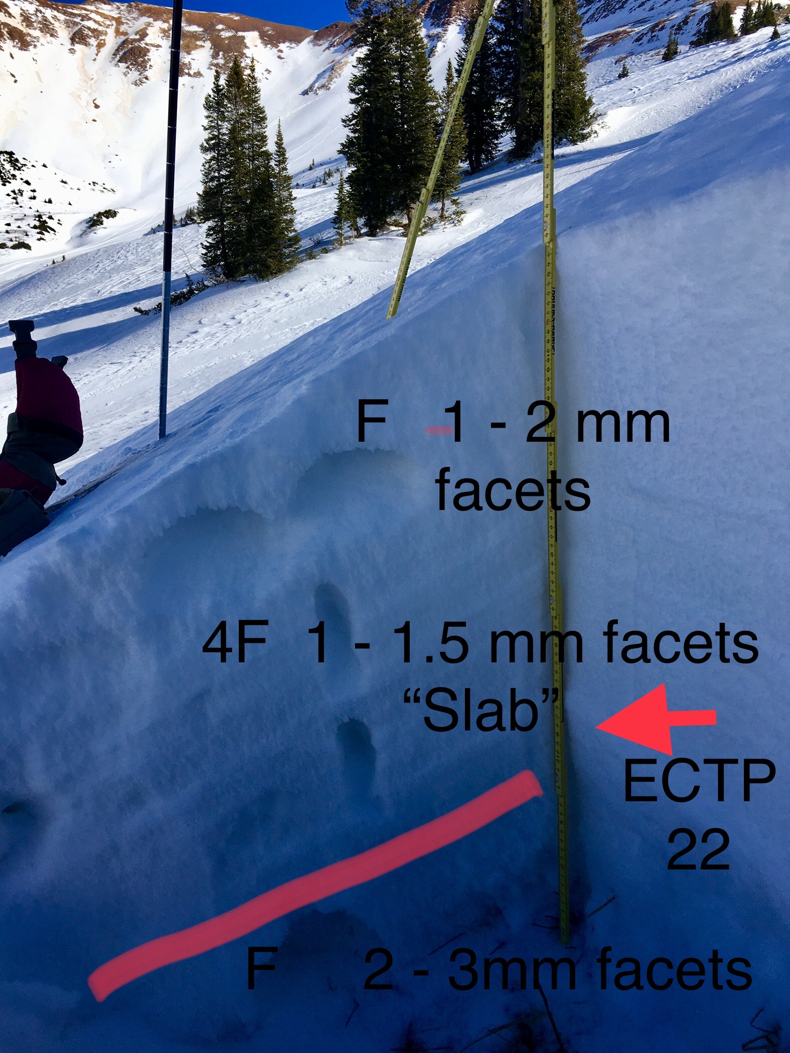
Mountain Weather 12/13/2017

CB Avalanche CenterWeather

Date: 12/13/2017

Look up today and you’ll see increasing cloud cover in advance of a small storm bringing snow to the mountains tonight. This system is sliding over the top of the ridiculously resilient ridge on the west coast, so it will hit us from the North. Snowflakes will begin to fall well after dark. By Thursday morning, we can expect a couple inches of fresh snow scattered around the southern side of the Elk Mountains. Tomorrow as the storm clears out, the North winds will blow and temps will drop a good 10 degrees over today. Looking deeper into the crystal ball, it looks like we’ve got another chance for snow coming late this weekend.

  • Today

    High Temperature: 30
    Winds/Direction: 5 to 15, Northwest
    Sky Cover: Increasing clouds
    Irwin Snow: 0
    Elkton Snow: 0
    Friend’s Hut Snow: 0

  • Tonight

    Low Temperature: 10
    Winds/Direction: 5 to 15, Northwest
    Sky Cover: Overcast
    Irwin Snow: 1 to 3
    Elkton Snow: 1 to 3
    Friend’s Hut Snow: 1 to 2

  • Tomorrow

    High Temperature: 20
    Winds/Direction: 10 to 20, gusting to 30, North
    Sky Cover: Partly Cloudy
    Irwin Snow: 0 to 1
    Elkton Snow: 0 to 1
    Friend’s Hut Snow: 0 to 1

Paradise divide tour

CB Avalanche Center2017-18 Observations

Location: Paradise Divide Area
Date of Observation: 12/11/2017
Name: Eric Murrow

Subject: Paradise divide tour
Aspect: North, North East, East, South East, South West, West, North West
Elevation: 9,600 – 11,750 Weather: Bluebird all day. Winds were blowing steady but light around 5 – 15, gusting to 20mph. Winds were out of the north. Air temps were pleasant with reading of 34f @ 11,100, 11:30am.
Snowpack: On the first part of our ascent went up westerly facing slopes 9,600 – 11,000. Snow surfaces were facets, and faceting crusts. Snow was shallow generally less than 35cm. Skiing was supportive.

Easterly slopes off of Cinnamon 11,000 – 11,750, were a again a mix of facets and crusts. Wind erosion has stripped much of this terrain, leaving many sculpted eroded features. Snow was supportive. Terrain features facing SE, out of the wind, softened just a cm or two which made for a few nice supportive, smeary turns around 1:30pm. Similar SE aspects the had more wind stayed cool and didn’t soften.

Dug one quick profile on an due North slope at 11,250 which had seen previous loading(HS 78cm), and found a cohesive slab resting over the Oct/early Nov snow. This site produced a hard propagating test result in an ECT (ECTP 21). This site had deeper snowpack than the immediate adjacent terrain, but shows the potential for isolated areas with deeper accumulations from loading to have a slab/weak layer present. See photo.

Photos:

Mountain Weather 12/12/2017

CB Avalanche CenterWeather

Date: 12/12/2017

First the same news, then the good news.
The PDS (or Pacific Deflector Shield) remains operational through at least this weekend when we expect the Resistance fighters to arrive in theaters near you. Today, clear skies, high temperatures in the mid 30’s and light northwest winds. Tonight the inversion sets back in under clear skies dropping valley temperatures back into the single digits. Then tomorrow, more of the same, though we’ll add a few high thin clouds.
So the good news – the long-range weather models hint at a pattern shift about a week away. We’ll leave it at that for now.

  • Today

    High Temperature: 35
    Winds/Direction: 5 to 15, Northwest
    Sky Cover: Clear
    Irwin Snow: 0
    Elkton Snow: 0
    Friend’s Hut Snow: 0

  • Tonight

    High Temperature: 25 at 11,000′; 5 in the valley bottom
    Winds/Direction: 5 to 15, Northwest
    Sky Cover: Clear
    Irwin Snow: 0
    Elkton Snow: 0
    Friend’s Hut Snow: 0

  • Tomorrow

    High Temperature: 32
    Winds/Direction: 5 to 15, Northwest
    Sky Cover: Mostly Clear
    Irwin Snow: 0
    Elkton Snow: 0
    Friend’s Hut Snow: 0

Washington Gulch and Paradise Divide

CB Avalanche Center2017-18 Observations

Location: Paradise Divide Area
Date of Observation: 12/11/2017
Name: Ben Pritchett

Subject: Washington Gulch and Paradise Divide
Aspect: North, North East, East, South East, South, South West, West, North West

Weather: Bluebird day with mild temperatures and light northwest winds.
Snowpack: Went in search of the elusive near treeline persistent slab structure. Evidence was very difficult to find. Only in Paradise Divide proper (behind Baldy) was there enough snow for any slab structure, and there it was extremely discontinuous and isolated to small pockets. Bumped into our CBAC intern, digging a profile near a profile we dug prior to the November 17th storm. Interestingly, the HS was nearly identical. The slab was less stiff today than a month ago. Elsewhere in the zone, away from the micro-snowclimate at Paradise Divide, the near treeline snowpack is simply too thin.

Photos:

Treasury Ridge

CB Avalanche Center2017-18 Observations

Location: Paradise Divide Area
Date of Observation: 12/10/2017
Name: Sydney Dickinson

Subject: Treasury Ridge

Snowpack: We spent the last two days on treasury ridge. Saw that the wine couloirs don’t go yet and a huge mt goat is living up there! Yesterday we skied south aspect. It was supportable but awful skiing. Today after getting denied from the couloir we dropped into rock creek on more of the east aspect and found some good turns in the wind riffles. Also supportable. Finished off the day with some sled laps on Baldy. Someone high marked the gut, got pretty high, no results.

Mountain Weather December 11th, 2017

CB Avalanche CenterWeather

Date: 12/11/2017

With the aid of my crystal ball, I can predict with a high degree of certainty that the sun will rise and fall, then rise and fall, followed by some more rising and falling. The crystal ball also shows a blip in this persistent ridge of high pressure that responsible for the dry weather. So we’ll be talking about a chance of some snow flurries Wednesday night. If you read yesterdays weather forecast, know that the BBBSFSRP group must be working hard as there appears to be some more winter weather for next weekend and maybe even some changes in the weather pattern! We shall see.
Valley inversions are again strong today. Valley temperatures should warm to near 40 degrees today with 11,000 temperatures reaching the mid 30’s. It may be dry but at least it sunny!

  • Today

    High Temperature: 36
    Winds/Direction: 5 to 15/NW
    Sky Cover: Clear
    Irwin Snow: 0
    Elkton Snow: 0
    Friend’s Hut Snow: 0

  • Tonight

    High Temperature: 20
    Winds/Direction: 5 to 15/N
    Sky Cover: Clear
    Irwin Snow: 0
    Elkton Snow: 0
    Friend’s Hut Snow: 0

  • Tomorrow

    High Temperature: 40
    Winds/Direction: 5 to 15/NW
    Sky Cover: Clear
    Irwin Snow: 0
    Elkton Snow: 0
    Friend’s Hut Snow: 0

Mountain Weather December 10th, 2017

CB Avalanche CenterWeather

Date: 12/10/2017

The Gunnison Valley Ice Skating Coalition and Crested Butte Ice Climbers for 2018 Club, continue to support a blocking ridge of high pressure over the Western half of the US. These two organizations will look forward to the continued dry weather through the foreseeable future. We can let the GVISC and CBICC have their weather that supports nice ice formation, but I hear the Big Bad Backcountry Skiers For Slate River Powder, are really working for a weather change and have something up their sleeve. Don’t forget to donate to the BBBSFSRP group because we really need some powder!
Low temperatures are again inverted this morning with valley lows near zero and 11,000ft temperatures in the 20’s. These temperatures should rebound nicely today and the clear sky will allow that beautiful Colorado sun to keep warming the sole.

  • Today

    High Temperature: 35
    Winds/Direction: 5-15/W
    Sky Cover: Clear
    Irwin Snow: 0
    Elkton Snow: 0
    Friend’s Hut Snow: 0

  • Tonight

    High Temperature: 20
    Winds/Direction: 5 to 15/W
    Sky Cover: Clear
    Irwin Snow: 0
    Elkton Snow: 0
    Friend’s Hut Snow: 0

  • Tomorrow

    High Temperature: 38
    Winds/Direction: 5 to 15/W
    Sky Cover: Clear
    Irwin Snow: 0
    Elkton Snow: 0
    Friend’s Hut Snow: 0

Mountain Weather 12/9/2017

CB Avalanche CenterWeather

Date: 12/09/2017

The classic winter inversion is in place this morning with temperatures near Crested Butte flirting with 0ºF, while higher elevation weather stations report temperatures at 6am closer to 20ºF. Another day of clear skies and bright sun are in store, with light winds at higher elevations blowing from the west. Keep the faith, the pattern will break down, but this persistent ridge of high pressure remains in place for the foreseeable future.

  • Today

    High Temperature: 33
    Winds/Direction: 5-15/WNW
    Sky Cover: Mostly Clear
    Irwin Snow: 0
    Elkton Snow: 0
    Friend’s Hut Snow: 0

  • Tonight

    High Temperature: 12
    Winds/Direction: 5-15/W
    Sky Cover: Mostly Clear
    Irwin Snow: 0
    Elkton Snow: 0
    Friend’s Hut Snow: 0

  • Tomorrow

    High Temperature: 35
    Winds/Direction: 5-15/W
    Sky Cover: Mostly Clear
    Irwin Snow: 0
    Elkton Snow: 0
    Friend’s Hut Snow: 0

Slate River/Cinnamon Mountain

CB Avalanche Center2017-18 Observations

Location: Paradise Divide Area
Date of Observation: 12/07/2017
Name: Ian Havlick

Subject: Slate River/Cinnamon Mountain
Aspect: East, South, South West, West
Elevation: 9500-11500

Avalanches:no new avalanches observed, but did see evidence of pretty widespread wet loose cycle in valley bottom. Weather: Overcast, flurries, cold and steady north wind all day. accumulations 1/2″. temps 14-19ºF.
Snowpack: did not encounter any persistent slabs in terrain travelled. Obvious crusts, sometimes supportable on more southerly slopes, 3mm facets below. Safe generalization would be that snowpack with depths less than 3ft is entirely faceted out, capped by 3-10cm melt freeze crust. Ice climbing is shaping up though and spelunking in 2017 snowpack is novel! New fallen snow was blowing into 2-4″ windslabs-no hazard.

Photos: