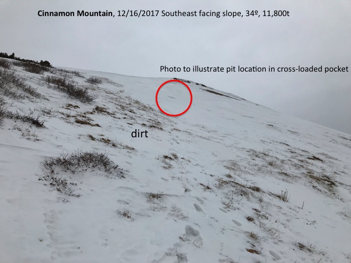
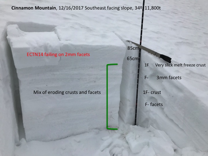
Mountain Weather December 17th, 2017

CB Avalanche CenterWeather

Date: 12/17/2017

Colorado is sitting in a big old sandwich. Where the meat and cheese are all dried out and the bread is soggy wet. A weird sandwich I know, but its true. There is a closed low eating tacos down south near the Mexican border and a wave of moisture being pushed over the ridge into Canada. Colorado just doesn’t have much going on for the next several days. Dry weather will take us through Wednesday. On Wednesday we should see clouds increasing and snow falling by Thursday!! That’s right people snow! The high-pressure ridge will have moved out further west and a low-pressure trough will move in.

  • Today

    High Temperature: 25
    Winds/Direction: 5 to 15/W
    Sky Cover: Partly Cloudy
    Irwin Snow: 0
    Elkton Snow: 0
    Friend’s Hut Snow: 0

  • Tonight

    Low Temperature: 12
    Winds/Direction: 5 to 15/W
    Sky Cover: Mostly Clear
    Irwin Snow: 0
    Elkton Snow: 0
    Friend’s Hut Snow: 0

  • Tomorrow

    High Temperature: 30
    Winds/Direction: 5 to 15/NW
    Sky Cover: Mostly Clear
    Irwin Snow: 0
    Elkton Snow: 0
    Friend’s Hut Snow: 0

Cinnamon Mountain

CB Avalanche Center2017-18 Observations

Location: Paradise Divide Area
Date of Observation: 12/16/2017
Name: Ian HAVLICK

Subject: Cinnamon Mountain
Aspect: East, South East, South, West
Elevation: 10,100-12,300

Avalanches:

no avalanches observed.

Weather: Overcast all day, chilly but only very light winds made day feel warmer. Minimal solar radiation.
Snowpack: Tale of two different snowpacks at the moment. near and below treeline snowpack is shallow and generally completely rotten and faceted. Big grained depth hoar, total sandbox, with depths ranging from total dirt to 50cm.

Above treeline, the snow surfaces are a war zone. Variable snow surfaces, very dense, slick, wind hammered. Dirt to crossloaded pockets 90cm deep. Snow structure is a beaten dog, 80% facets, with some real firm hardslabs (pencil+ to knife hard). These conditions are not dangerous at the moment, but will be looking at poor instability with any new snow loads. At ridge crest, Wednesday’s 1″ accumulations had drifted to 6-8″ but minimally cracking under boot foot.

Photos:

Mountain Weather

CB Avalanche CenterWeather

Date: 12/16/2017

Weak valley inversion will begin to mix out this morning with increasing clouds into the afternoon as another weak Pacific disturbance withers on the vine and loses all potential precipitation as it moves across the Great Basin. Look for a few flurries tonight over our highest terrain along the spine of the Elk Mountains, with just a skiff of accumulating snow. Sunny days return again, before our much anticipated mid week storm rolls in. This digging trough from the Pacific looks to bring advisory level snowfall (4-8”+) to our area before the low pressure cuts off and severs its moisture tap. While not a season saver, it is a step in the right direction…

  • Today

    High Temperature: 35
    Winds/Direction: 5-15/SW
    Sky Cover: Increasing clouds
    Irwin Snow: 0″
    Elkton Snow: 0″
    Friend’s Hut Snow: 0″

  • Tonight

    Low Temperature: 15
    Winds/Direction: 5-15/SW
    Sky Cover: Mostly Cloudy
    Irwin Snow: tr
    Elkton Snow: tr
    Friend’s Hut Snow: tr

  • Tomorrow

    High Temperature: 25
    Winds/Direction: 5-15/WSW
    Sky Cover: Mostly Cloudy
    Irwin Snow: 0
    Elkton Snow: 0
    Friend’s Hut Snow: 0

Washington Gulch

CB Avalanche Center2017-18 Observations

Location: Crested Butte Area
Date of Observation: 12/15/2017
Subject: Photos taken from up Washington Gulch
Aspect: North East
Elevation: 10,843

Weather: Sunny with little wind
Snowpack: Facets to the ground beneath a crust layer with a dusting of snow on top from Wednesday night’s storm. Some areas had no new snow dusting and some areas were deeper, maybe 2 inches of new snow.


Little Italian Mountain/Taylor Pass

CB Avalanche Center2017-18 Observations

Location: Upper Taylor Area
Date of Observation: 12/15/2017
Name: Ben Pritchett

Subject: Little Italian Basin (Italian Joe Pass) / Taylor Pass
Aspect: South, South East
Elevation: 10-12,000ft

Avalanches:

Observed several D1 windslabs near Little Italian Basin and Taylor Pass.

Snowpack: north winds transported snow onto SE facing slopes above treeline. At 11,000ft we saw a 50cm entirely faceted snowpack. Once above treeline, the snowpack is wind and sun ravaged, with pockets of sunbaked hardslab between scoured and crusted facet beds.

Mountain Weather

CB Avalanche CenterWeather

Date: 12/15/2017

The bottom dropped out across our forecast area with temperatures hovering in the single digits, and below zero readings over in Taylor Park. We will have yet another quiet day on our hands with drifting cirrus ahead of our next hiccup of a weather system weakening across the Great Basin today, on deck to give us another skiff of snow this weekend. We will have a major change in the weather next week, but just a little too early for solid details. Colder and stormier look like good bets for the rest of the December though.

  • Today

    High Temperature: 30
    Winds/Direction: 5-15/NW
    Sky Cover: Mostly Clear
    Irwin Snow: 0
    Elkton Snow: 0
    Friend’s Hut Snow: 0

  • Tonight

    Low Temperature: 15
    Winds/Direction: 5-15/WSW
    Sky Cover: Partly Cloudy
    Irwin Snow: 0
    Elkton Snow: 0
    Friend’s Hut Snow: 0

  • Tomorrow

    High Temperature: 35
    Winds/Direction: 5-15/SW
    Sky Cover: Mostly Cloudy
    Irwin Snow: 0
    Elkton Snow: 0
    Friend’s Hut Snow: 0

Coney’s

CB Avalanche Center2017-18 Observations

Location: Crested Butte Area
Date of Observation: 12/12/2017
Name: Cam Smith

Subject: Coney’s
Aspect: North East
Elevation: 10,700

Avalanches:

None observed


Weather: Warm and sunny. Above freezing in the afternoon. Calm winds.

Snowpack: 15-35cm HS. Generally deeper as you got higher and in loading prone areas. Thin, fragile sun crust on the surface. 1-2mm facets to the ground, everywhere. No signs of instability.

Photos:

Poverty Gulch to Richmond Mountain

CB Avalanche Center2017-18 Observations

Location: Paradise Divide Area
Date of Observation: 12/13/2017
Name: Eric Murrow

Subject: Poverty Gulch to Richmond Mountain
Aspect: North, North East, East, West, North West
Elevation: 9,250 – 12,500

Avalanches:

Weather: Morning started with few clouds/nearly clear and at 10am clouds rolled in and was overcast the rest of the day. Winds were well behaved with speeds of only about 5mph, infrequent questing up to about 10mph. At summit of Richmond winds were still very light out of the west. Overall pleasant day for a walk.

Snowpack: Most surfaces were either facets, faceting windboard, or a few crusts. Travel was generally quite supportive, making travel easy.

On the way up, we crossed many wind loaded pockets (still only around 70cm deep, N -E aspects) near and above treeline and had no collapsing or shooting cracks. Dug numerous quick hand pits in these deeper pockets; rarely found slab/weaklayer structure. Many of these deeper wind deposits were just supportive windboard over very weak F hardness facets. Had a hard time finding hazardous structure. Slab structure was very small in surface area and was discontinuous from rest of slope, even in areas with same surface conditions.

Ski conditions were mostly crap, but at least supportive. Here are a few photos showing snowcover over some of this terrain.

Photos:

Mountain Weather

CB Avalanche CenterWeather

Date: 12/14/2017

Though this fast moving, and unsettled wave of moisture has only dropped an inch or two across our forecast area, it is a welcomed sign the sustained ridge of high pressure is weakening. The residual moisture from this wave will clear out throughout the morning, leaving cold, dry air in its wake. High pressure will try to re-build, with another similar blip on the radar Saturday night. Looking into next week, models suggest the relentless high pressure has been wounded and will struggle to rebuild, before yet another digging trough across the California coastline opens the interior up for desperate moisture. Future models are even hinting that Santa and Rudolph have bigger, better presents on track for next week.

  • Today

    High Temperature: 25
    Winds/Direction: 10-20/NNW
    Sky Cover: Decreasing clouds
    Irwin Snow: 0-1″
    Elkton Snow: 0-1″
    Friend’s Hut Snow: 0

  • Tonight

    Low Temperature: 8
    Winds/Direction: 5-15/NW
    Sky Cover: Mostly Clear
    Irwin Snow: 0
    Elkton Snow: 0
    Friend’s Hut Snow: 0

  • Tomorrow

    High Temperature: 32
    Winds/Direction: 5-15/WNW
    Sky Cover: Mostly Clear
    Irwin Snow: 0
    Elkton Snow: 0
    Friend’s Hut Snow: 0