Mountain Weather

CB Avalanche CenterWeather

Date: 03/04/2018

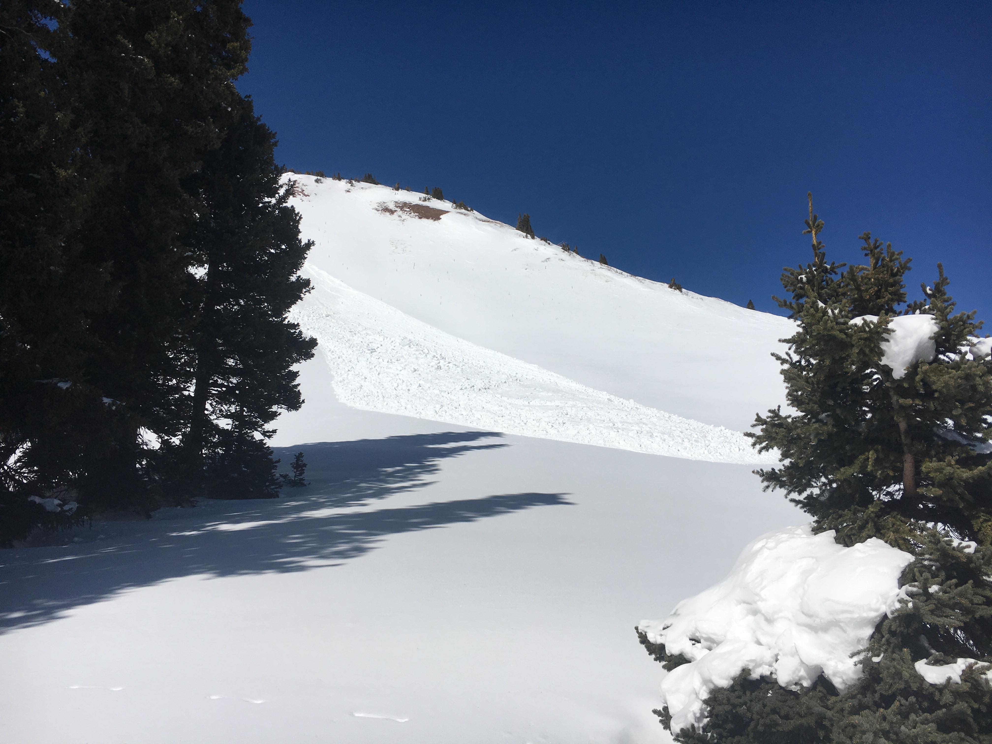
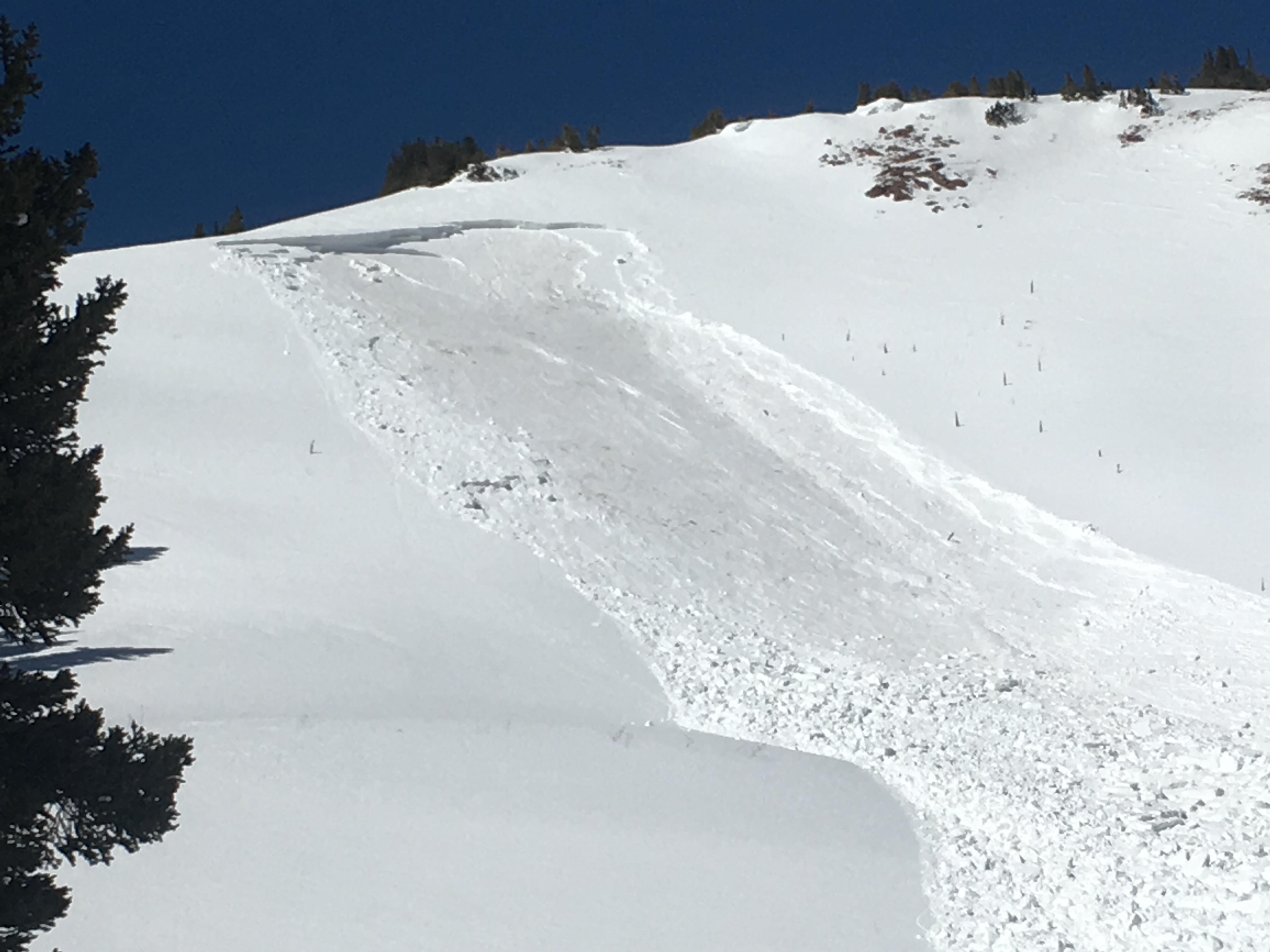
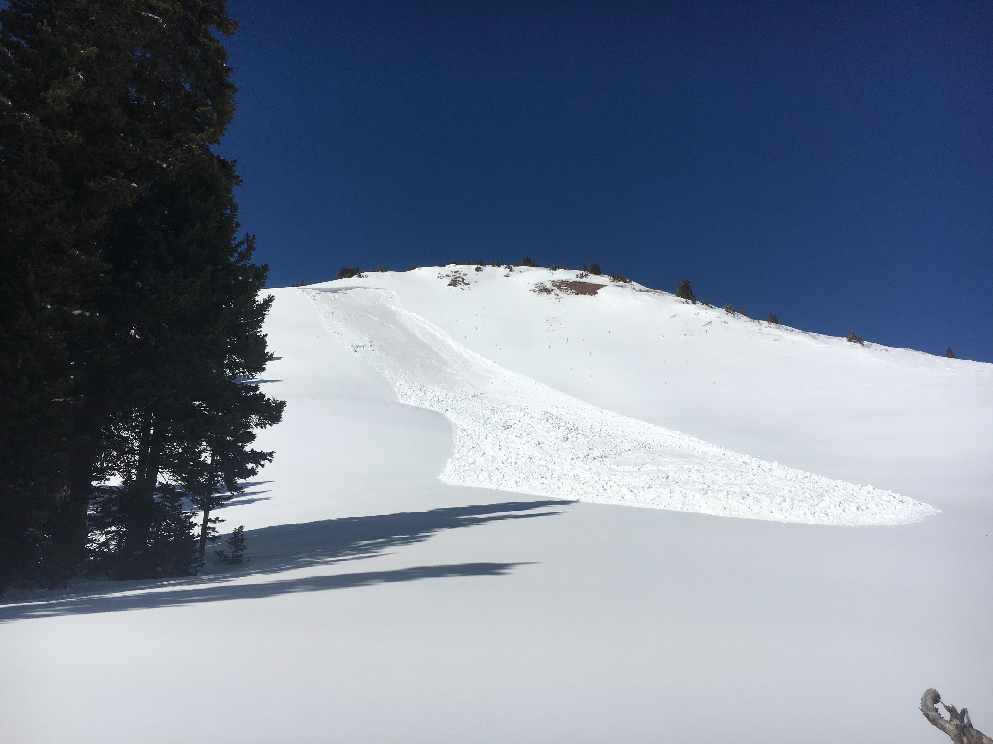
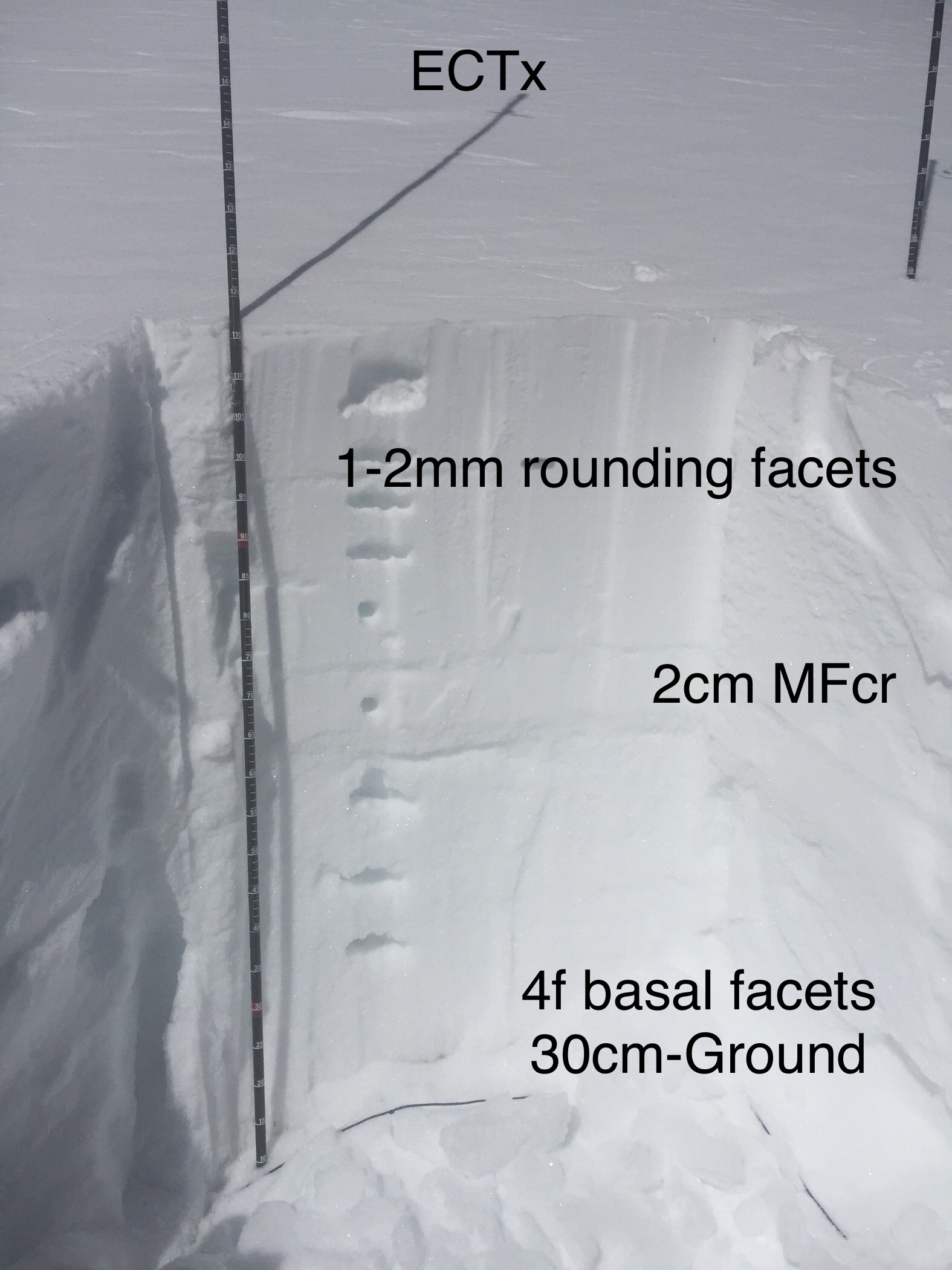
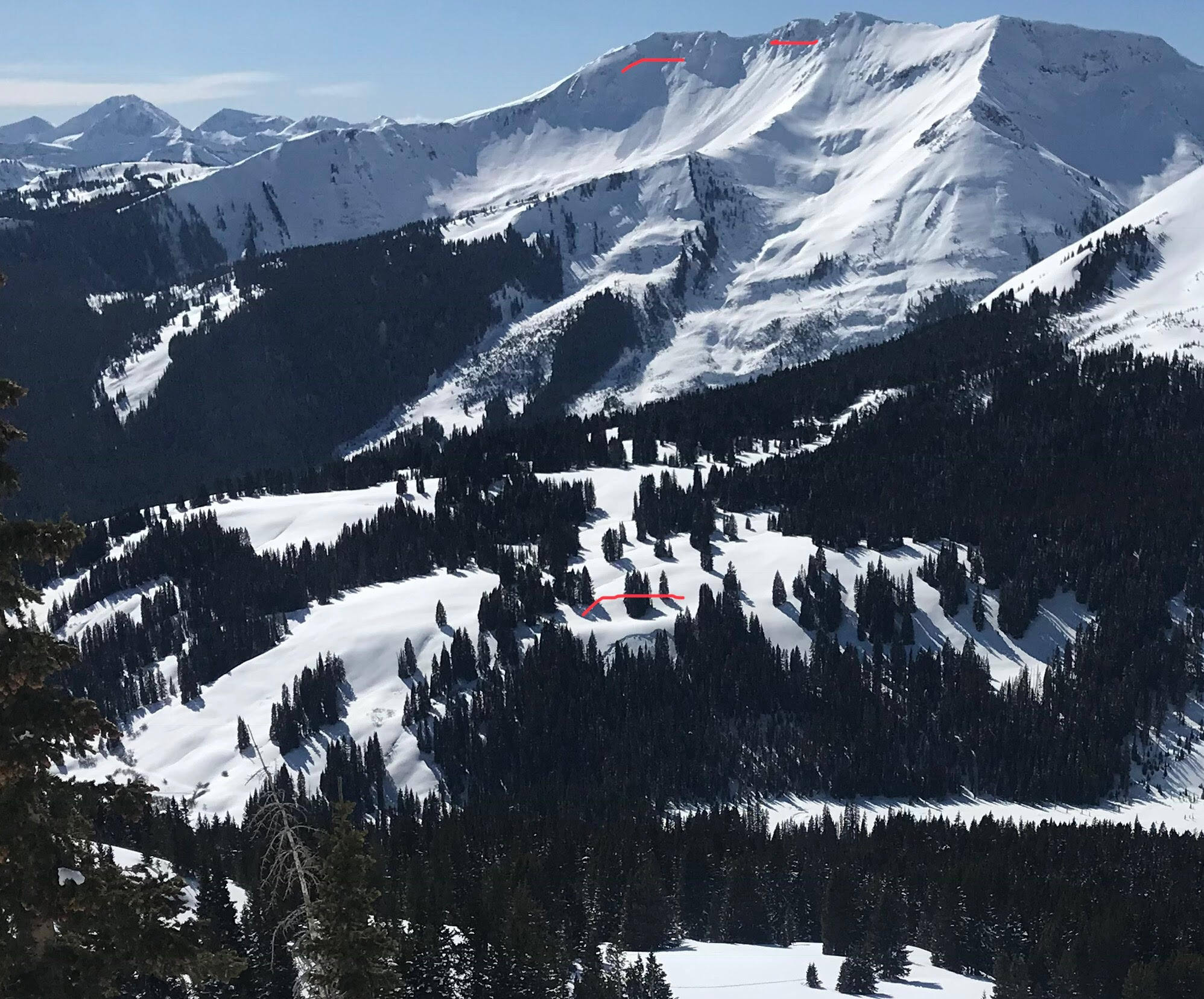
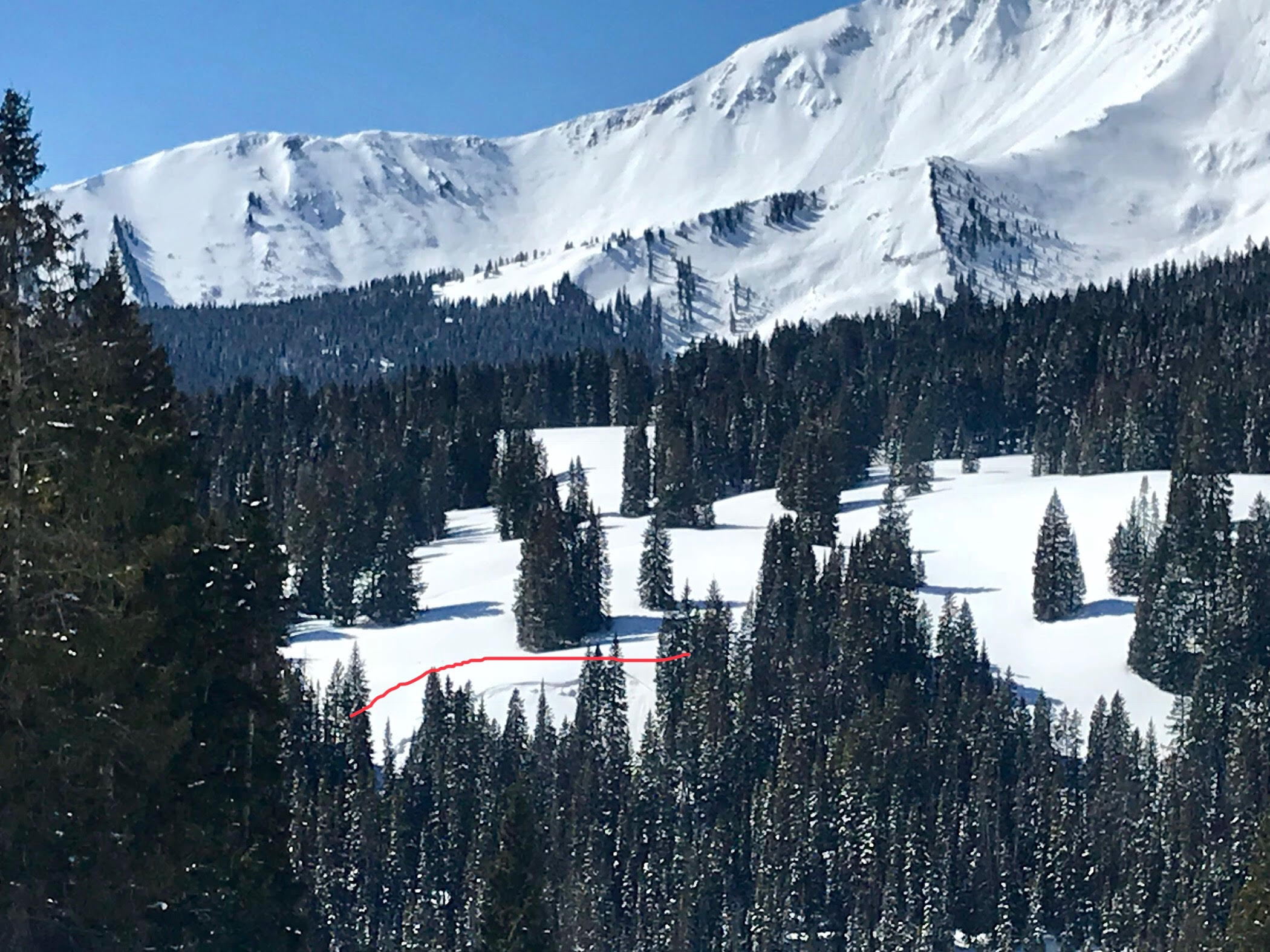
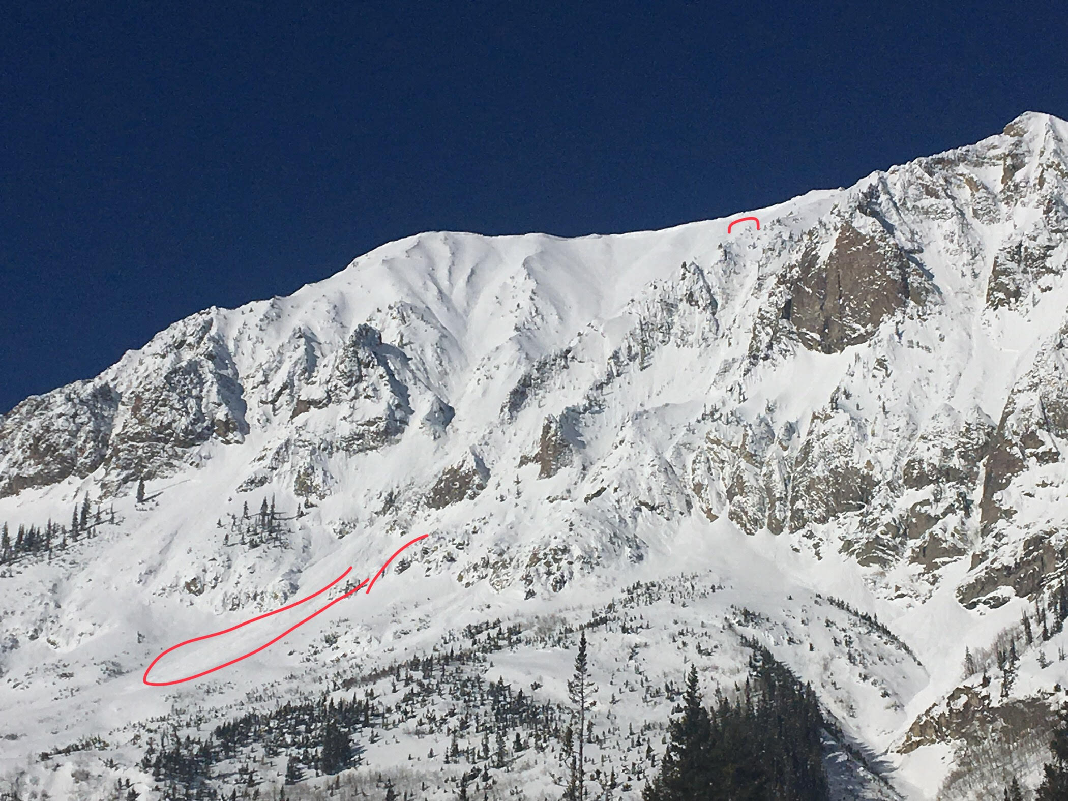
It will be hard to believe looking out your window this morning that snow will fall midday.  A sharp cold front slowed yesterday over Utah, and today will ride a strong jet stream aloft into Colorado.  Model runs of this storm over the last few days have begun to shy off precipitation as the Wasatch wrings this stalled system dry. The exact timing of this cold front is somewhat uncertain, but will be obvious when it passes midday to early afternoon.  Strong winds and intense snowfall will signal the front (maybe even some thundersnow?), and cold air will rush in behind the front.  Daytime highs may be reached this morning, before the cold front, with temperatures set to drop to the single digits tonight. Cold, northwest flow will linger through the night and minor orographics for Kebler and Schofield Passes cannot be ruled out.  Looking ahead, we have a dry and warm week on tap, with potentially another weak storm toward next weekend.

  • Today

    High Temperature: 33
    Winds/Direction: 20-30 G50/SW
    Sky Cover: Increasing clouds
    Irwin Snow: 3-6″
    Elkton Snow: 3-6″
    Friend’s Hut Snow: 2-4″

  • Tonight

    Low Temperature: 5
    Winds/Direction: 15-25/WNW
    Sky Cover: Mostly Cloudy
    Irwin Snow: 0-2″
    Elkton Snow: 0-2″
    Friend’s Hut Snow: 0-1″

  • Tomorrow

    High Temperature: 15
    Winds/Direction: 10-20/WNW
    Sky Cover: Partly Cloudy
    Irwin Snow: 0
    Elkton Snow: 0
    Friend’s Hut Snow: 0

Mountain Weather

CB Avalanche CenterWeather

Date: 03/03/2018

Another very warm and windy day on tap ahead of drastic changes for tomorrow. A classic spring-like cold front is churning across the Great Basin today and looks to arrive on our doorstep tomorrow around 10am. This cold front will bring strong winds, intense snowfall rates and maybe some of that dreaded desert dust. Snowfall will continue throughout much the day, and cold northwest orographics may over produce in the Kebler and Schofield Pass areas. Total accumulations look to be 6-8” with higher amounts possible.

  • Today

    High Temperature: 38
    Winds/Direction: 15-25/SW
    Sky Cover: Mostly Clear
    Irwin Snow: 0
    Elkton Snow: 0
    Friend’s Hut Snow: 0

  • Tonight

    Low Temperature: 15
    Winds/Direction: 10-20/SSW
    Sky Cover: Increasing clouds
    Irwin Snow: 0
    Elkton Snow: 0
    Friend’s Hut Snow: 0

  • Tomorrow

    High Temperature: 25
    Winds/Direction: 10-20G50/WNW
    Sky Cover: Mostly Cloudy
    Irwin Snow: 6-8″
    Elkton Snow: 6-8″
    Friend’s Hut Snow: 3-6″

Remote Trigger Cement Creek

CB Avalanche Center2017-18 Observations

Location: Cement Creek Area
Date of Observation: 03/01/2018
Name: Caleb Weinberg

Subject: Remote Trigger Cement Creek
Aspect: South East
Elevation: NTL

Avalanches:

“Slide was on a SE aspect. We triggered it from the flat deck that the first photo showing only bottom of the slide is taken from. About 300 yards from the crown which was 4’ish. I’d say r2 d2. It ran the first half of its path but couldn’t get over the flat to get to the second half. Three sleds had ridding to the trigger spot and when the fourth got there we felt a giant whumph. Really good example for us on how just because one person (or3) doesn’t trigger doesn’t mean it won’t happen.”

Weather: CLear, warm
Snowpack:

Photos:

Mountain Weather

CB Avalanche CenterWeather

Date: 03/02/2018

In like a lamb is what they say, and aside from increasing southwesterly winds, it will feel spring-like across the Elk Mountains with temperatures up to 10 degrees above normal. An organized low pressure system continues to sit over the west coast for another day, before ejecting out over the Great Basin and giving us our next snowfall Sunday. This storm and its associated cold front will roll through Sunday morning, potentially dropping 5-10” snow across higher terrain, with snow in the valleys as well.

  • Today

    High Temperature: 38
    Winds/Direction: 10-20/SW
    Sky Cover: Mostly Clear
    Irwin Snow: 0
    Elkton Snow: 0
    Friend’s Hut Snow: 0

  • Tonight

    Low Temperature: 21
    Winds/Direction: 10-20/SW
    Sky Cover: Mostly Clear
    Irwin Snow: 0
    Elkton Snow: 0
    Friend’s Hut Snow: 0

  • Tomorrow

    High Temperature: 38
    Winds/Direction: 15-25/SW
    Sky Cover: Mostly Clear
    Irwin Snow: 0
    Elkton Snow: 0
    Friend’s Hut Snow: 0

E-SE ATL obs

CB Avalanche Center2017-18 Observations

Location: Paradise Divide Area
Date of Observation: 03/01/2018
Name: Alex Banas

Subject: E-SE ATL obs
Aspect: East, South East
Elevation: NTL

Avalanches:

None. No CR, CO, AV observed.

Weather: Clear in the AM transitioning to scattered by 1300. Warm temps, moderate solar, Calm winds.
Snowpack: HS : 117cm. Persistent slab structure is present but not reactive in snowpack tests. The E-SE at treeline snowpack on the Gothic shoulder is harboring only a few melt-freeze crusts and a strong midpack. True east surface conditions stayed dry throughout the day with anything with more of a southerly tilt becoming moist by 1200.

Photos:

Axtell Green Lake Bowl natural

CB Avalanche Center2017-18 Observations

Location: Kebler Pass Area
Date of Observation: 03/01/2018
Name: Ben Pritchett

Subject: 1@1
Aspect: North East
Elevation: 12,000′

Avalanches:

Stop Please! And the natural avalanche cycle creeps onwards. Yet another one today, failed this morning off Axtell, Green Lake Bowl. SS-N-R1/D2-O, to the ground.

Failed below a cornice, above and below a cliff, to the ground on depth hoar. Ran before 11am March 1st on a sunny north of east aspect. Close up doesn’t show any large pieces of cornice broken off, winds were the lightest they have been in days.

Photos:

Natural D2 off Mt. Axtell, 3/1

Mountain Weather March 1, 2018

CB Avalanche CenterWeather

Date: 03/01/2018

The western US sits under a broad ridge of high pressure at the moment. A large trough is stalled on the Oregon Coast, spinning light moisture, observable as high thin clouds, towards us today. Then tomorrow that moisture tap dries up we’ll see our first truly spring-like day of March.
That trough will remain parked on the coast through Saturday, pounding the Sierra with snow, before ejecting eastward across the continent to bring us a quick shot of snow on Sunday followed by cooler dry air early next week.

  • Today

    High Temperature: 28
    Winds/Direction: 10 to 20, Southwest
    Sky Cover: Increasing clouds
    Irwin Snow: 0
    Elkton Snow: 0
    Friend’s Hut Snow: 0

  • Tonight

    Low Temperature: 10
    Winds/Direction: 10 to 20, Southwest
    Sky Cover: Partly Cloudy
    Irwin Snow: 0
    Elkton Snow: 0
    Friend’s Hut Snow: 0

  • Tomorrow

    High Temperature: 35
    Winds/Direction: 15 to 25, South-Southwest
    Sky Cover: Clear
    Irwin Snow: 0
    Elkton Snow: 0
    Friend’s Hut Snow: 0

Mountain Weather February 28th, 2018

CB Avalanche CenterWeather

Date: 02/28/2018

A moisture-starved closed low-pressure system is tracking through southern Arizona right now. Given the placement of this spinning top of a system and the lack of moisture, any hopes for significant snows today can now be erased. We’ll see clouds all day, a chance for a few snowflakes in the AM, and a steady shot of westerly wind after lunch. That’s it for this “storm.”
Tomorrow temperatures rebound to near freezing and we’ll get covered by a band of high clouds reaching out in front of a large Alaskan low dropping down into the western US. We expect this system to bring some snow to Crested Butte on Sunday.

  • Today

    High Temperature: 20
    Winds/Direction: 5 to 15, gusting to 25 out of the West in the PM
    Sky Cover: Mostly Cloudy
    Irwin Snow: 0 to t”
    Elkton Snow: 0 to 1″
    Friend’s Hut Snow: 0 to 1″

  • Tonight

    Low Temperature: 5
    Winds/Direction: 5 to 15 West Northwest
    Sky Cover: Mostly Cloudy
    Irwin Snow: 0
    Elkton Snow: 0
    Friend’s Hut Snow: 0

  • Tomorrow

    High Temperature: 32
    Winds/Direction: 5 to 15, Southwest
    Sky Cover: Increasing clouds
    Irwin Snow: 0
    Elkton Snow: 0
    Friend’s Hut Snow: 0

The first big Southeast face avalanche of the winter

CB Avalanche Center2017-18 Observations

Location: Kebler Pass Area
Date of Observation: 02/27/2018
Name: Ben Pritchett

Subject: The first big Southeast face avalanche of the winter
Aspect: South East
Elevation: Above Treeline

Avalanches:

The natural cycle that wont’ quit! 3 more D3’s, that ran today, plus at least on D2 wind slab.
Ruby Mtn. North Face, D2 windslab that ran today (Tuesday, 2/27)
Afley Southeast Face, D3 monster!!! that ran today (Tuesday, 2/27)
Afley North Face, D3 that ran Monday
Oh-Be-Joyfull Pass, D3, Persistent Slab that stepped down to Deep Slab

Weather: Light to Moderate winds today, but almost no snow transport and loading today. Noticeably warmer, with snow surfaces moistening on sunny slopes to 12,000′.

Photos:

Gothic area obs

CB Avalanche Center2017-18 Observations

Location: Crested Butte Area
Date of Observation: 02/27/2018
Name: Steve Banks

Subject: Gothic area obs
Aspect:
Elevation:

Avalanches:

Fresh windslabs observed on E Face of Gothic (R1-D2) E Face of Baldy (R1-D2) sometime last night and persistent slab on NE slope 40 degrees @ 10,400’ toward Rustlers Gulch on a steep convex rollover. (SS-N-R1-D2-O) in a terrain trap. Approx 48 hours old. See photos attached.

Weather: Warm with high of +2C and calm winds. Upper elevations saw breezy conditions from the NW. Strong solar radiation took a toll on what was left of the dry snow. No précis but did notice a passing cloud or two.
Snowpack: Surfaces a mixed bag of dry snow, sun crusts from zipper to 2” from yesterday’s sun and warm temps. Appearance of RC faceted crystals over the crust. W-NW steeper slopes held dry snow this morning while S-SE crusts softened by noonish. Probing and Ski pole poking revealed variable depths up to 120 cms but mostly “junky” snow with many crust/facet layers. SE slopes visited blow treeline have very little snow with lots of rocks showing.

Photos:

Wind slabs on E side of Baldy and the BTL convex slab.

Good look at the Mt Belleview slide.

Random below TL slab up Rustlers

Wind slab on Gothic. Crown at top, debris at bottom