Slate River storm snow

CB Avalanche Center2017-18 Observations

Location: Paradise Divide Area
Date of Observation: 03/19/2018
Name: Eric Murrow

Subject: Slate River storm snow
Aspect: North, North East, East
Elevation: 8900′ – 10400′

Avalanches:

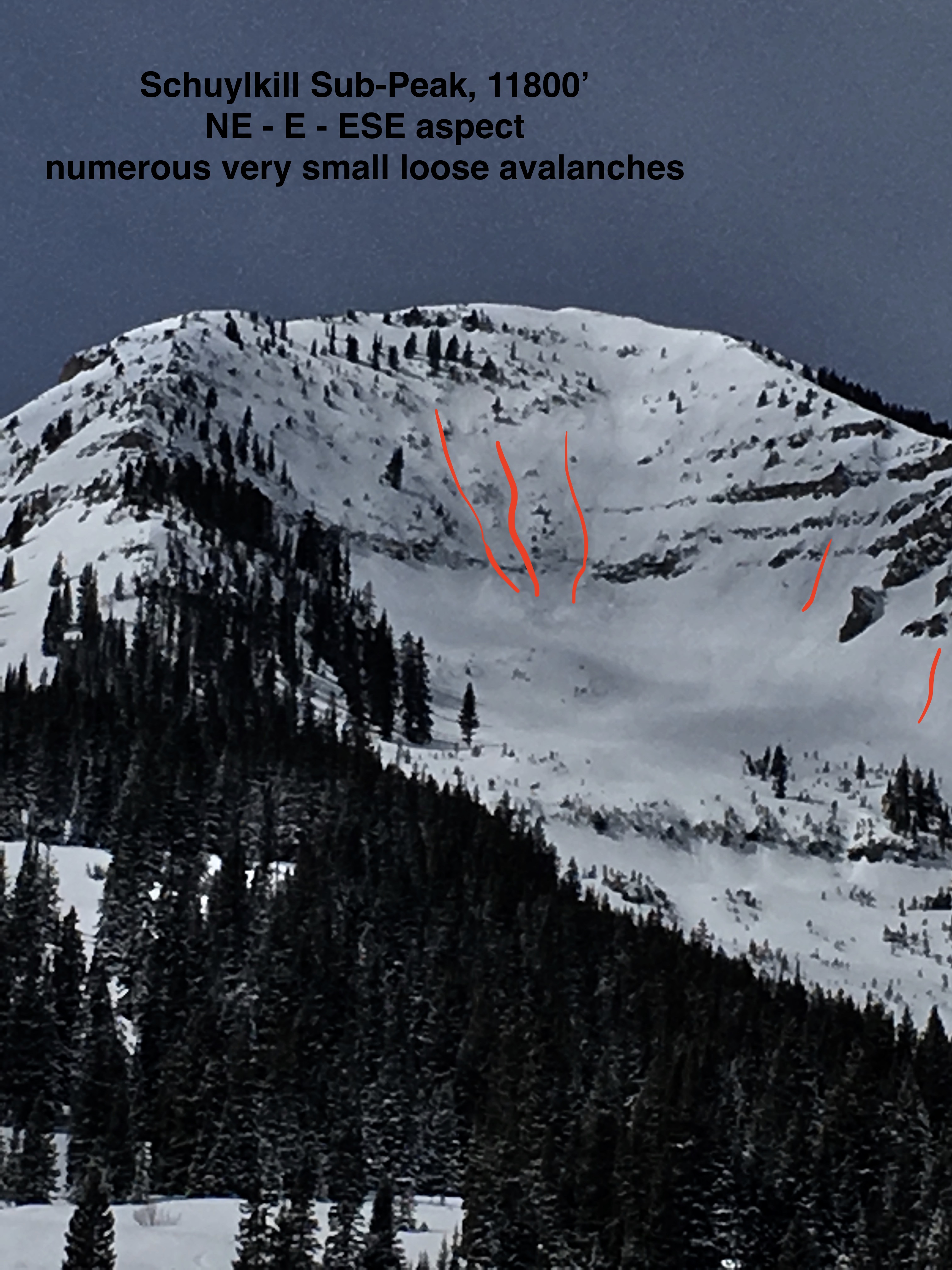
Many skiers and boarders out testing steep near and below treeline terrain on northerly slopes. Few very small skier triggered loose sloughs of little consequence, and one skier triggered, D2, storm slab avalanche on Schuylkill Ridge (documented in earlier ob). Numerous very small natural loose avalanches in new snow coming out of steep rocky cliff areas near and above treeline.

Weather: Partly cloudy skies with thicker cloud cover moving over the spine of Ruby Range. Light winds at below treeline elevations, vis of above treeline terrain was in and out, but observed no snow transport.
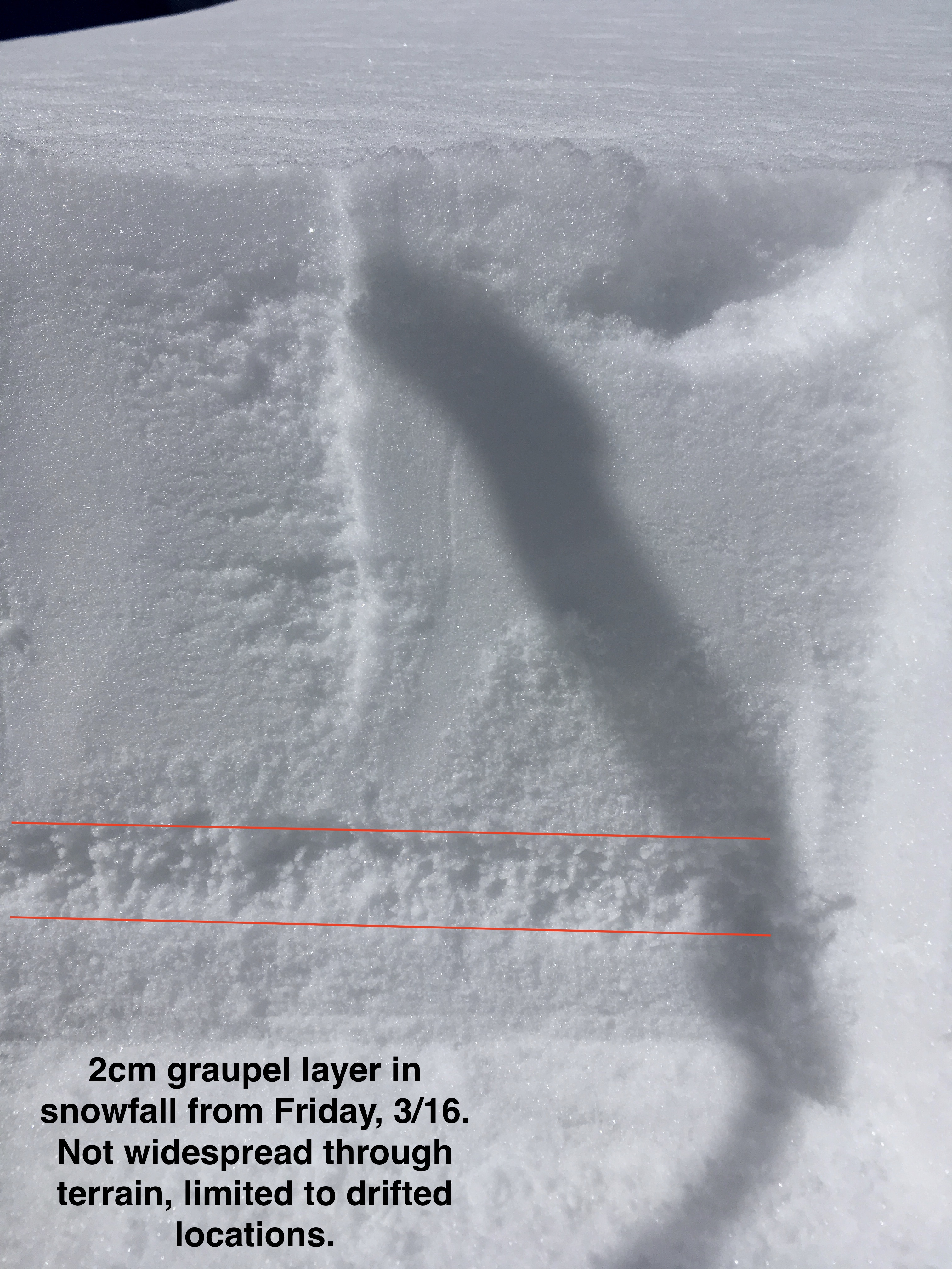
Snowpack: New snow accumulations were 3″ at Slate river TH and increased up 5″ at 10400′. Small isolated drifts below treeline were up to 9″ deep, but no cracking was observed. Terrain that faced NW – NE had dry snow underneath new snow but NE – E had 1-3cm sun crust below new snow (faceting was apparent below the crust, and could be a problem if a significant load is deposited in near future). Also of note – found graupel layer in drifted areas from Friday’s storm(3/16), CT’s produced moderate results on the graupel but no slab present above just low-density storm snow. Graupel layer was not widespread throughout below treeline northerlies limited to terrain features that were drifted after Friday’s storm on terrain features that were slightly tilted to the east.

Photos:
Mountain Weather March 20, 2018

CB Avalanche CenterWeather

Date: 03/20/2018

Northwest flow will continue for Tuesday with clouds filtering into the area throughout the day. Air temps will rise from yesterday to more normal highs. Clouds and warmer air will continue into Wednesday. The next hit of snow comes by Friday morning with Thursday acting as a transition day. Get ready for more pow this weekend; winter has not given up on us just yet.

  • Today

    High Temperature: 30
    Winds/Direction: 10 to 20, West
    Sky Cover: Partly Cloudy
    Irwin Snow: 0
    Elkton Snow: 0
    Friend’s Hut Snow: 0

  • Tonight

    Low Temperature: 13
    Winds/Direction: 5 to 15, West
    Sky Cover: Mostly Cloudy
    Irwin Snow: 0
    Elkton Snow: 0
    Friend’s Hut Snow: 0

  • Tomorrow

    High Temperature: 37
    Winds/Direction: 5 to 15, West
    Sky Cover: Mostly Cloudy
    Irwin Snow: 0
    Elkton Snow: 0
    Friend’s Hut Snow: 0

Schuylkill skier triggered slide

CB Avalanche Center2017-18 Observations

Location: Crested Butte Area
Date of Observation: 03/19/2018
Name: CBAC

Subject: Schuylkill skier triggered slide
Aspect: East
Elevation: 11,200′

Avalanches:

Skier triggered slide spotted from the valley. SS-AS-R1/D2-I.  Triggering party said “Ran on sun crust. Soft and ran like slough”.

Photos:

Mountain Weather March 19, 2018

CB Avalanche CenterWeather

Date: 03/19/2018

Yesterday’s storm has now passed the area and moved well to the east into the Great Plains. Northwest flow has kicked in and air temperatures have dropped considerably. Clouds will filter through today with the potential for orographic snow across high terrain to the west and north of town with the possibility of just a skiff of accumulation. A ridge of high-pressure builds for Tuesday through Thursday.

  • Today

    High Temperature: 22
    Winds/Direction: 10 to 20, Northwest
    Sky Cover: Partly Cloudy
    Irwin Snow: 0 to 2
    Elkton Snow: 0 to 2
    Friend’s Hut Snow: 0 to 1

  • Tonight

    Low Temperature: 6
    Winds/Direction: 5 to 15, Northwest
    Sky Cover: Partly Cloudy
    Irwin Snow: 0
    Elkton Snow: 0
    Friend’s Hut Snow: 0

  • Tomorrow

    High Temperature: 28
    Winds/Direction: 10 to 20, West
    Sky Cover: Partly Cloudy
    Irwin Snow: 0
    Elkton Snow: 0
    Friend’s Hut Snow: 0

Mountain Weather March 18, 2018

CB Avalanche CenterWeather

Date: 03/18/2018

Another round of winter is wobbling like a top towards Crested Butte. Snowfall will ramp up after the noon hour; right about the time the costume wearing fun freaks at the AJ start racing. This system might be a bit unpredictable and could produce bursts of intense snowfall during the afternoon especially along the spine of the Ruby Range from Irwin to Schofield Pass.

  • Today

    High Temperature: 28
    Winds/Direction: 7 to 17
    Sky Cover: Overcast
    Irwin Snow: 4 to 7
    Elkton Snow: 4 to 7
    Friend’s Hut Snow: 3 to 5

  • Tonight

    Low Temperature: 10
    Winds/Direction: 10 to 20 G30, Northwest
    Sky Cover: Mostly Cloudy
    Irwin Snow: 3 to 5
    Elkton Snow: 3 to 5
    Friend’s Hut Snow: 2 to 4

  • Tomorrow

    High Temperature: 23
    Winds/Direction: 7 to 17
    Sky Cover: Mostly Cloudy
    Irwin Snow: 0 to 1
    Elkton Snow: 0 to 1
    Friend’s Hut Snow: 0 to 1

Remote trigger in Red Well

CB Avalanche Center2017-18 Observations

Location: Crested Butte Area
Date of Observation: 03/16/2018
Name: Dave

Subject: Remote trigger in Red Well
Aspect: North, North West
Elevation: 12, 300

Avalanches:

We skied a lap in red lady bowl, then went back up and dropped into red well. Remotely triggered a slide from the bottom on red well, 1st skier triggered the slide. It was a R1, D2.

Weather: Overcast in the Am cleared to sunny
Snowpack: New snow 3-5 in of new snow. Was deeper in loaded areas we skied. Did not see signs of instability of during tour.

Photos:

Crown roughly 24 of 4-finger drifted new snow.

Remote triggered from the furthest looker’s right point.

Fresh avalanche in Red Well, 2/16/2018.

Mountain Weather March 17, 2018

CB Avalanche CenterWeather

Date: 03/17/2018

Today will begin with mostly clear skies with clouds increasing throughout the day in front of the next storm system which arrives later tonight. Air temperatures will warm to near or just above the freezing mark. A slight chance for a few snowflakes is possible late in the day. “The Dudes” next bowling ball closed low will begin impacting the area in earnest tonight and into tomorrow.

  • Today

    High Temperature: 34
    Winds/Direction: 10 to 20, Southwest
    Sky Cover: Partly Cloudy
    Irwin Snow: 0 to 1
    Elkton Snow: 0 to 1
    Friend’s Hut Snow: 0 to 1

  • Tonight

    Low Temperature: 15 to 20
    Winds/Direction: 7 to 17, South-Southwest
    Sky Cover: Mostly Cloudy
    Irwin Snow: 0 to 2
    Elkton Snow: 0 to 2
    Friend’s Hut Snow: 0 to 1

  • Tomorrow

    High Temperature: 25 to 30
    Winds/Direction: 7 to 17
    Sky Cover: Overcast
    Irwin Snow: 3 to 6
    Elkton Snow: 3 to 6
    Friend’s Hut Snow: 2 to 5

Snodgrass

CB Avalanche Center2017-18 Observations

Location: Crested Butte Area
Date of Observation: 03/16/2018
Name: ADB

Subject: Snodgrass
Aspect: East, South East
Elevation: BTL

Avalanches:

Starting zone on slope greater than 30 degrees, cause loose slough (4 inches deep) which picked up more snow for about 300 feet. Snow piled up enough to bury one’s dog or knock you off balance.
On a a slope between 25 and 30 degrees, started another loose slough, which didn’t have the slope and energy to travel more than 25 feet.


Weather: Mixed weather: S-1/obscured skies/clear skies
light breeze

Snowpack: Between two to four inches of new snow on sun crusts in last 24 hours.

Photos:

Mountain Weather March 16, 2018

CB Avalanche CenterWeather

Date: 03/16/2018

Here we are, 20 years after the Big Lebowski. Coincidentally, there’s a large upper-atmosphere low-pressure system, let’s just call it “the Dude,” that’s bowling a series of closed lows across the western US this week into next. Each frame will bring a shot of snow, cooler temps and wind.
The first of these bowling balls crashed through Colorado yesterday, dropping well over a foot at Wolf Creek Pass, and 3 to 8 inches of fresh pow around the upper Gunnison Valley. Irwin picked up 5″, Schofield 8″, CBMR 4″, Upper Taylor 2″.
Today the Dude knocks back a cold one, while we sit under a brief shot of high pressure. Tomorrow the Dude bowls the next storm our way, spinning in Saturday night into Sunday.

  • Today

    High Temperature: 25
    Winds/Direction: 10 to 20, gusting to 30, West
    Sky Cover: Decreasing clouds
    Irwin Snow: 0 to 3″
    Elkton Snow: 0 to 3″
    Friend’s Hut Snow: 0 to 1″

  • Tonight

    Low Temperature: 15
    Winds/Direction: 5 to 15, South
    Sky Cover: Mostly Clear
    Irwin Snow: 0
    Elkton Snow: 0
    Friend’s Hut Snow: 0

  • Tomorrow

    High Temperature: 35
    Winds/Direction: 10 to 20, gusting to 35, Southwest
    Sky Cover: Partly Cloudy
    Irwin Snow: 0
    Elkton Snow: 0
    Friend’s Hut Snow: 0

Coney’s

CB Avalanche Center2017-18 Observations

Location: Crested Butte Area
Date of Observation: 03/15/2018
Name: Ben Pritchett

Subject: Coney’s
Aspect: North East, East
Elevation: 9-10,900 K

Weather: Convective showers all day, adding up to 2-3″ of snow by 3pm. Very greenhouse feeling, w/ intense radiation between the bursts of snow. Light southerly winds.
Snowpack: Dense rimed snow fell on wet snow surfaces. Very good bond between the saturated surface and the new snow initially, though it’s worth checking for “dry snow over melt layer” faceting at that interface in the near future as that interface freezes. Boot penetration was 10-20cm outside of very shallow isothermal areas. The melt water of the last couple days has changed the BTL snow surfaces to a very dense and consolidated cap over the old weak snow.