stability on SW slopes

CB Avalanche Center2018-19 Observations

Location: Paradise Divide Area
Date of Observation: 12/03/2018
Name: Lawson Yow

Subject: stability on SW slopes
Aspect: South West
Elevation: 11,000

Avalanches:

No signs of instability. No cracks, whumpfs, or visible signs of avalanche activity.

Weather: Stormy
Snowpack: 60-100 cm deep
looking pretty uniform in hasty hand pits
Low angle pow

Photos:

Pittsburgh

CB Avalanche Center2018-19 Observations

Location: Kebler Pass Area
Date of Observation: 12/03/2018
Name: MR

Subject: Pittsburgh
Aspect: North East
Elevation: 9,500-10,500

Avalanches:

A few small debris piles presumably from storm snow instabilities over the weekend. No instabilities felt or seen today on or off the skintrack or while skiing.

Weather: Snowing S1 pretty much all day, cold, low winds
Snowpack: 3 inches new snow. Pole probing off the skintrack in the trees still showed little structure in the snowpack.

Photos:

Red Coon Glades – Whumphs and Shooting Cracks – Touchy Observations

CB Avalanche Center2018-19 Observations

Location: Kebler Pass Area
Date of Observation: 12/03/2018
Name: Chris Martin

Subject: Red Coon Glades – Whumphs and Shooting Cracks – Touchy Observations
Aspect: South East
Elevation: 11,000′

Avalanches:

N/O

Weather: calm , no drifiting snow observed.
Obscurred cloud cover
S-1 throughout the morning
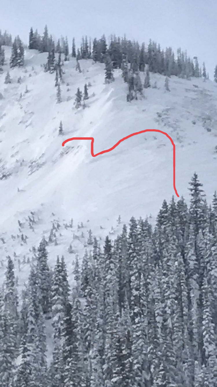
Snowpack: Skied up through Coon glades today recognizing signs of instability, including whumpfs and shooting cracks that failed at similar depths on our tour up, all the way down to weak layer of facets. Weak layer did fluctuate characteristics on ascent. Appeared as Fist layer 10-15 cm of Basal facets at Pit #1 and changing to a Pencil hard 5cm frozen Layer crust at the ground with 2 mm facets above the crust. Test Results below. Great day to wiggle the low angle slopes.

Shooting Crack Pit #1:
HS 55cm SE Aspect 10,500′
F- 4F – F (top-Bottom)
Slab structure barely present but enough to whumpf, shoot a crack, and Fail on isolation of CT
Failures appearing on 10-15 cm layer of 1-2mm Basal Facets
CTV at crust above 10-15 cm layer of basal facets
No need for a Propagation test here, snow above column failed on isolation as well – see photos

Pit #2:
HS 70cm SE Aspect 11000′
F-4F-1F- P (top-Bottom)
Slab structure present in this pit
@30 cm from surface within storm snow CT 20 Q3 PC
@55cm from surface MFcr observed with 2mm FC directly above crust – PST 45 SF – See video
MFcr about 5 cm thick frozen at the ground

Photos:

Mountain Weather for 11,000ft

CB Avalanche CenterWeather

Date: 12/03/2018

A low-pressure trough is slowly creeping across Colorado today and into tonight. This trough will keep the snow production going but with modest accumulations through tonight. Orographic snowfall from westerly winds could bump snow totals up in locations along the Ruby Range. Air temperatures will remain below seasonal averages. The next approaching storm will begin to impact Colorado on Thursday.

  • Today

    High Temperature: 10 to 15
    Winds/Direction: 5 to 15, W
    Sky Cover: Overcast
    Irwin Snow: 1 to 3″
    Elkton Snow: 1 to 3″
    Friend’s Hut Snow: 0 to 2″

  • Tonight

    Low Temperature: -5 to 0
    Winds/Direction: 5 to 15, W
    Sky Cover: Mostly Cloudy
    Irwin Snow: 0 to 2
    Elkton Snow: 0 to 2
    Friend’s Hut Snow: 0 to 2

  • Tomorrow

    High Temperature: 10 to 15
    Winds/Direction: 5 to 15, W
    Sky Cover: Partly Cloudy
    Irwin Snow: 0 to 1
    Elkton Snow: 0 to 1
    Friend’s Hut Snow: 0 to 1

Snodgrass Obs

CB Avalanche Center2018-19 Observations

Location: Crested Butte Area
Date of Observation: 12/02/2018
Name: Alex Tiberio

Subject: Snodgrass Obs
Aspect: North East
Elevation: 10,000

Avalanches:

None observed

Weather: Partly cloudy skies in AM light snow moving in around 3PM
Snowpack: Still whumping and collapsing. ECTP14 Q1 on a 33 degree slope failing on facets below the thanksgiving snow.

Photos:

Kebler Obs

CB Avalanche Center2018-19 Observations

Location: Kebler Pass Area
Date of Observation: 12/02/2018
Name: Joey Carpenter

Subject: Kebler Obs
Aspect: North, North East, East
Elevation: 10200-11200

Avalanches:

1. Axtell 4th bowl observed from trailhead area. Appeared to be R1D2 windslab.
2. East bowl above friendly finish windslab. R1D1.5.

Weather: Broken skies from 930-1100am and calm winds -> overcast at 12pm with intermittent S1 snowfall, increasing winds and moderate snow transport at 11200 feet.
Snowpack: Storm snow has gained cohesion (F–>F+) since yesterday in the upper snowpack. NE aspect 11k moderate collapse in flat terrain. N Aspect 11.2k large, rumbling collapse that propagated well away from our party.

Photos:

Mountain Weather for 11,000ft

CB Avalanche CenterWeather

Date: 12/02/2018

After a frigid night with temperatures single digits in the alpine, and single digits below zero in the valleys, high clouds have begun to stream in ahead of a moisture starved shortwave working across southern Utah. This storm will be more of a snowmaker for the San Juans, but we should see light accumulations late this afternoon and tonight. Light to moderate westerly winds will increase ahead of this disturbance near and above treeline, and temperatures will stay cold for the next few days. The active storm pattern will continue into next week.

  • Today

    High Temperature: 11
    Winds/Direction: 15-20/WSW
    Sky Cover: Increasing clouds
    Irwin Snow: 1-3″
    Elkton Snow: 1-3″
    Friend’s Hut Snow: 0-2″

  • Tonight

    Low Temperature: 0
    Winds/Direction: 5-15/W
    Sky Cover: Mostly Cloudy
    Irwin Snow: 1-3″
    Elkton Snow: 1-3″
    Friend’s Hut Snow: 0-2″

  • Tomorrow

    High Temperature: 15
    Winds/Direction: 5-15/W
    Sky Cover: Mostly Cloudy
    Irwin Snow: 0-2″
    Elkton Snow: 0-2″
    Friend’s Hut Snow: 0-2″

Irwin Cat Ski Obs

CB Avalanche Center2018-19 Observations

Location: Kebler Pass Area
Date of Observation: 12/01/2018
Name: Irwin Guides

Subject: Irwin Cat Ski Obs
Aspect: South, South West
Elevation: 10500′-12000-

Avalanches:

Touchy loose dry running fast. No Storm slabs observed today. Collapsing and cracking
still prevalent in previously travelled terrain like outerlimits. Both noticed above and below the rock band.

Weather: Deep day at Irwin. HST 23″ with 2.2″ SWE. Our HS is now sitting at 46″ for the season. Seems like we out performed both the WRF and the Open snow forecast for the second part of the three part storm cycle.
Snowpack: CT and ECT failing on isolation on facets below 11/22 interface.

Photos:

Paradise Divide

CB Avalanche Center2018-19 Observations

Location: Paradise Divide Area
Date of Observation: 12/31/2018
Name:

Subject:
Aspect: East
Elevation:

Avalanches:

Experienced sluffing on slopes greater than 38 degrees.

Weather: Intermittent snow and sunshine with north wind gusting below tree line.
Snowpack: Dry snow with roughly 1.5-2 feet of storm snow on top of weak early season layers. Wind loading even below treeline

Photos:

Mountain Weather for 11,000ft

CB Avalanche CenterWeather

Date: 12/01/2018

The Crested Butte area is currently sitting under a northwest flow with cold air sagging towards us. Snowshowers will continue through midday, but will largely be concentrated along the Ruby Range. Some showers may push into interior parts of the range near town. Winds will be moderate today with the potential for snow transport. Expect temperatures to cool down for today and Sunday. The next disturbance will push into the area on Sunday from the southwest.

  • Today

    High Temperature: 10 to 20
    Winds/Direction: 10 to 20, WNW
    Sky Cover: Mostly Cloudy
    Irwin Snow: 3-6″
    Elkton Snow: 2-5″
    Friend’s Hut Snow: 2-5″

  • Tonight

    Low Temperature: 0 to 5
    Winds/Direction: 10 – 15, W
    Sky Cover: Mostly Cloudy
    Irwin Snow: 0
    Elkton Snow: 0
    Friend’s Hut Snow: 0

  • Tomorrow

    High Temperature: 10 to 20
    Winds/Direction: 10 -15, N
    Sky Cover: Mostly Cloudy
    Irwin Snow: 0 to 3
    Elkton Snow: 0 to 3
    Friend’s Hut Snow: 0 to 3