


Mountain Weather for 11,000ft
Date: 12/07/2018
Wind speeds have really dropped off since midnight allowing for calm conditions Friday morning. Low-level clouds have filled into the valleys creating overcast sky. Those winds will remain light today and those low-level clouds should dissipate a bit throughout the day, but you can still expect upper-level clouds to keep it a mostly cloudy kind of day. The chance for light snow still remains with this moisture in the area. Going into the weekend, this morning’s southwesterly flow will become westerly on Friday and eventually northwesterly by Saturday. We’ll see clouds and moisture slowly decreases during this time, before conditions dry out as a high-pressure ridge moves in for later this weekend and takes us into the start of next week.
-
Today
High Temperature: 28
Winds/Direction: 0 to 10, WSW
Sky Cover: Mostly Cloudy
Irwin Snow: 0 to 1 AM
Elkton Snow: 0 to 1 AM
Friend’s Hut Snow: 0 to 1 AM -
Tonight
Low Temperature: 15
Winds/Direction: 5 to 15 WNW
Sky Cover: Partly Cloudy
Irwin Snow: 0 to 1
Elkton Snow: 0 to 1
Friend’s Hut Snow: 0 to 1 -
Tomorrow
High Temperature: 28
Winds/Direction: 5 to 15 G25, WNW
Sky Cover: Partly Cloudy
Irwin Snow: 0
Elkton Snow: 0
Friend’s Hut Snow: 0
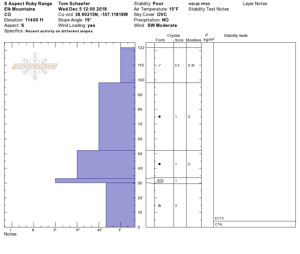
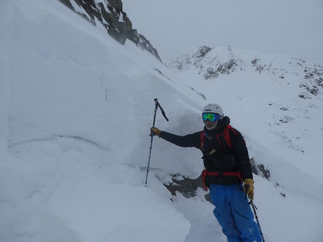
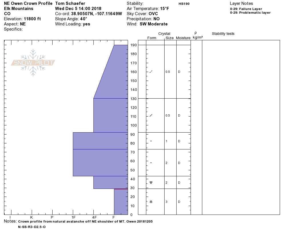
Mt. Owen Profiles
Location: Kebler Pass Area
Date of Observation: 12/05/2018
Name: Tom Schaefer
Subject: Mt. Owen Profiles
Aspect: North East, South
Elevation: 11400′
Avalanches:
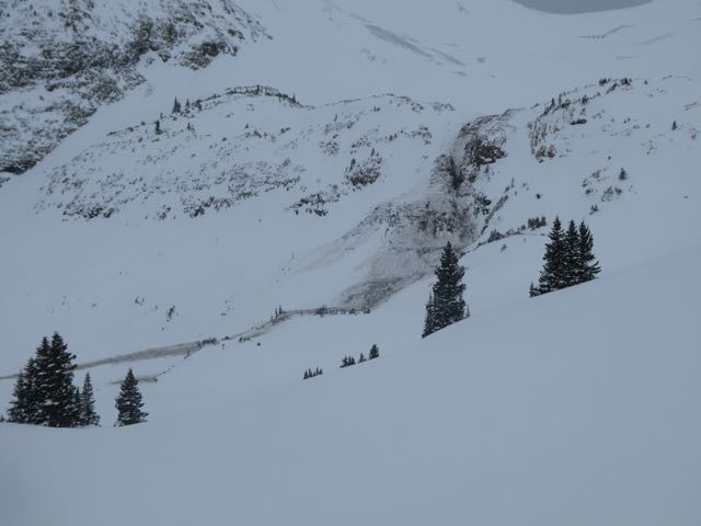
12/4/2018
#1 (Green Lake Gully Washer) N-SS-R2-D3-O
#2 (SE lookers right of GLGW) N-SS-R2-D2-O
12/5/2018
#3 (NE shoulder of Owen) N-SS-R2-D2.5-O
Appears all 3 failed on the Nov. 22 interface
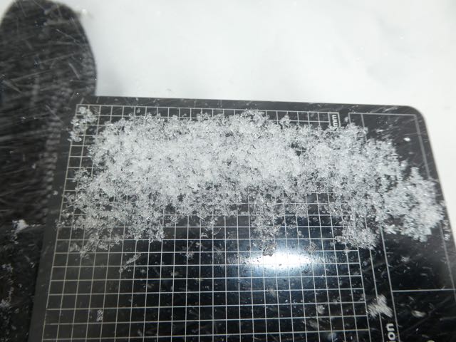
Weather: Overcast throughout the day temps in the teens with steady moderate winds from the SW. ATL snow was continuously being transported onto lee slopes.
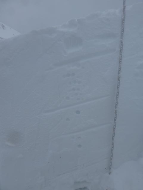
Snowpack: Headed out to Mt. Owen to check out 3 natural avalanches off Mt. Owen that occurred between the 4th and 5th. Ski pen 15cm, boot pen 65cm. Avg. HS on the bench below Owen was 120cm avg. Along Scarp ridge on the windward side was avg. of 30cm. of soft snow . Pack has become more supportive, but in general there is still plenty of snow available for transport.
Photos:

Human Triggered Avalanche
Location: Kebler Pass Area
Date of Observation: 12/06/2018
Name:
Subject: Human Triggered Avalanche
Aspect: West
Elevation: 10,800
Avalanches:
Human Triggered Avalanche. 2 caught and carried, none buried.
Weather: Temps were in the mid 20’s, predominately OVC skies, at the time of the slide S-1 squalls where passing through, although about 20 min prior to activity there was a very brief, but noticeably warm break in the cloud cover. Creeper wind loading previous days with minimal new snow.
Snowpack: We had a skier triggered slide on 12/6 at 2:30 PM, west facing, ~11,000’, mid 30’s slope, Sunset Left/Outer Limits Interface. ASu-SS-R1-D2-O 125cm max crown height, ~25’ wide and ran ~200’ in a very narrow path thru a few woods at the start zone, max debris around 150cm. One guide was caught, lost gear and has a minor back injury, but able to work. We are grateful.
Control teams had been thru that zone (and surrounding runs) previous days with hand shots and 7lbAnfo Airblast shots (7lbs Info w 2lbs of Dyno) and singles. That morning, our Control team had been thru Sunset Left with hand shots. We also placed Anfo charges on adjacent slopes, at that same elevation, that produced no results. I personally skied just below the start zone that morning to check the area prior to sending packers in there.
Second lap, our team spread out a bit, Guide #1 went into an adjacent pocket. He noticed it was deeper then normal and proceeded to pull his shovel out to take a look at the structure. One packer followed him in and then Guide #2 skied in, they all felt a collapse and the pocket pulled out above Guide #2 who was slightly below the other 2 skiers. Guide 1 grabbed his pack to put back on, lost his shovel, but had eyes on the whole time. Guide 2 and packer were caught, packer was tangled for a moment but found edges and skied out. Guide 2 fell forward, grabbed a tree, but was pulled off and somersaulted a few times down the slope before landing up right facing downhill in the debris pile. He was buried to his knees, lost all ski gear, and at the time, felt shaken but injury free. He later has been dealing with a sore back.
Photos:


Snodgrass obs
Location: Crested Butte Area
Date of Observation: 12/06/2018
Name: IG
Subject: Snodgrass obs
Aspect: East
Elevation: 10,000
Avalanches:
None observed
Weather: Snowing S1, little wind, warm temps approaching freezing. Began snowing a bit harder at 15:30
Snowpack: Traveling off the beaten path we observed widespread collapsing in large areas but observed no cracks. Weak structure near the ground with facets, over a crust on the ground. 4 finger above to fist near the top. HS 30-60 cms.
Photos:
West Brush Creek from Monday 12/3
Location: Brush Creek Area
Date of Observation: 12/03/2018
Name: Eric Murrow
Subject: West Brush Creek from Monday 12/3
Aspect: North East, East, South East
Elevation: 9,000′ – 11,000′
Avalanches:
Surprisingly only ID’d one slab through this terrain. Very small D1 tucked immediately below ridge top on NE aspect.
Weather: Cold day with mostly cloudy skies and light flurries. No accumulation. Winds were mellow at below treeline locations. Did not observer transport across higher terrain.
Snowpack: HS ranged from around 40 to 75 cm across terrain and variety of aspects. While walking through low angle meadows we were able to produce numerous collapses below Thanksgiving slab. A few of these collapses ran around 75′. The goal for this day was to identify if Persistent Slab structure existed in this shallower part of the forecast area. SE and S aspects below treeline were bare ground prior to Thanksgiving storm – structure consisted of 20cm 1F hard Thanksgiving slab on ground, 2 to 3cm melt/freeze crust capping Thanksgiving snow, top 25cm from the storm this past weekend. No real issues S and SE below treeline.
East and northeast were a different story. Much of this terrain showed thick melt/freeze crust at the ground from October snow, 15cm of 2-3mm facets from early November, 20-25cm 1F Thanksgiving slab, topped with 25cm low-density snow from last weekends storm. Structure out west Brush Creek on shady slopes mirrored areas in Kebler and Paradise Divide below treeline but snow totals were shallower and Thanksgiving slab is only 6″ – 10″ thick. The real concern in this area is collapsing below the Thanksgiving slab. The profile included below is for one such site. We were able to produce propagating results on NE @ 11,000′. Slabs are just thick enough and hard enough that avalanches are possible. We did not get up to the drifted near treeline terrain in this area, but looking through binoculars made leeward start zones look much deeper than below treeline.
Photos:
-

- Red dot is location of profile site
-
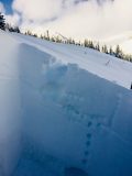
- Profile photo of strong over weak structure.
-

- ECTP result
-

- Profile data
Fresh wind drifts at ridgeline
Location: Kebler Pass Area
Date of Observation: 12/05/2018
Name: Evan Ross
Subject: Fresh wind drifts at ridgeline
Aspect: East, South
Elevation: 9,500-11,500
Avalanches:
Weather: Overcast sky. Light to Moderate westerly winds drifting snow at ridgeline.
Snowpack: Traveled in this same area on 12/3. Measured HS at the same location as on 12/3. At 11,300ft, south aspect HS was 90cm. That was a 10cm drop since the last time I was there, but more snow has also fallen during that time so the drop would have been greater, compared to the unmeasured peak snowpack hight. Ski pen had decreased and the upper snowpack had gained strength in those couple days. On southerly facing slopes, our group of three observed no obvious signs to instability regarding a persistent slab issue. Put some hard ski cuts on a few southeast slopes as well, but otherwise chose to avoid skiing on those slopes.
At the near treeline elevation, near the ridge, there had been a good amount of wind-loading over the last few days. Pervasively northerly winds had loaded some good sized drifts over the top of the ridge, while today the westerly winds were cross loading the rips in the terrain. The drifts were thick to ski through, but didn’t budge under a few ski cuts. Still managed the terrain off the ridge with windslabs in mind.
On easterly facing slopes BTL, the obvious signs to instability had greatly decreased since 12/3. The PS structure was still there, but we were not getting the shooting cracks and booming collapses as often. Still chose to avoid slopes greater than about 32 degrees in this area.
Photos:

Fresh Drifts loading a south aspect at ridgeline. While todays winds were cross-loading snow across the ribs in the terrain. Plenty of fresh snow to move around.
owen pics
Location: Kebler Pass Area
Date of Observation: 12/05/2018
Name: Tom Schaefer
Subject: owen pics
Aspect: East, South East
Elevation: 12,000
Avalanches: SS-N-R3-D2.5-O
Weather: OVC, MoD WSW winds
Snowpack: New snow loading

Avalanche from 12/5 in there AM on SE flank of Mt. Owen

Released 12/4 in the PM on South face-off Mt. Owen

Crown on SE shoulder of Mt. Owen
Photos:
Mountain Weather for 11,000′
Date: 12/06/2018
Radar shows some more moisture downstream from us today which will add a couple more inches to the fluff we receives last night. This pattern of light snow, moderate winds and cool temperatures will continue into the weekend when we should see more clearing and sunny skies.
-
Today
High Temperature: 20
Winds/Direction: West-Southwest 5-15 mph
Sky Cover: Overcast
Irwin Snow: 1-3″
Elkton Snow: 1-3″
Friend’s Hut Snow: 1-3″ -
Tonight
Low Temperature: 15
Winds/Direction: West-Southwest 5-15 mph
Sky Cover: Overcast
Irwin Snow: 1-3″
Elkton Snow: 1-3″
Friend’s Hut Snow: 1-3″ -
Tomorrow
High Temperature: 20
Winds/Direction: West-Southwest 5-15 mph
Sky Cover: Mostly Cloudy
Irwin Snow: 1-3″
Elkton Snow: 1-3″
Friend’s Hut Snow: 1-3″
Red Lady Glades (11:15-14:00).
Location: Crested Butte Area
Date of Observation: 12/05/2018
Name: ADB
Subject: Red Lady Glades (11:15-14:00).
Aspect: South East, South, South West
Elevation: BTL/NTL/ATL
Avalanches:
BTL/NTL/ATL-no avalanches on slopes skied which were mostly less than 30 degrees.
Unlike two weeks ago, no shooting cracks or whumping on skin track and off skin track at BTL. and NTL.
No shooting cracks or whumping on skin track at ATL.
Weather: obscured skies with variable winds with respect to elevation:
BTL: calm
NTL Light to moderate winds with some snow transport onto east slopes
ATL: Intermittent moderate winds with snow transport onto east slopes
Snowpack: BTL-unconsolidated snow up to 12 inches. Rocks are barely covered on some rocky sections. Skier with gear weighs 120lbs.
NTL-4 inch soft slabs forming with 0.5 inches of wind blown snow in skin track.
Hand tests revealed a melt freeze crust 8 inches deep on SE slope. No cracking or propogating cracks with hasty tests.
ATL-1-2 inch hard slabs and skin track is filled in.
Photos: