Coon Lady

CB Avalanche Center2018-19 Observations

Location: Kebler Pass Area
Date of Observation: 01/02/2019
Name: Chris MArtin

Subject: Coon Lady
Aspect: South East, South, South West, West
Elevation: 9,000-12,395′
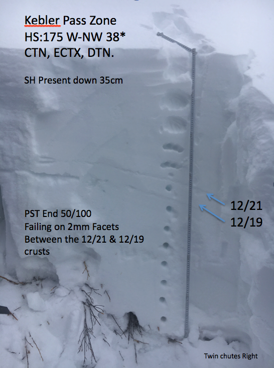
Avalanches:

N/O

Weather: Sunny, Warm
Snowpack: Today we observed excellent ski conditions. Throughout ascent, we observed new years snow softly laid over the terrain. As we traveled up in elevations near the Coon Summit and Red lady summit, isolated pockets of wind slab were observed. Slabs ranging from 2-6″ thick and reactive under foot and hand shear tests. One small shooting crack observed within new wind transported snow at the top of coon summit. Red lady bowl entrance showed signs of wind slab in the upper upper start zone near the small cornices. Careful Route finding was pertinent today. Persistent Slab Structure Present on these SE-SW aspects in upper elevations.
Also, Surface Hoar formation on the surface from 9,000′ to about 10,000′ , observed while ascending coon glade.

Photos:

Mountain Weather for 11,000ft

CB Avalanche CenterWeather

Date: 01/02/2019

How about some arctic beach weather to close out the week! Sound fun honey? Well, it better because that’s what you are going to get! It is frigid cold out there this morning, but that big ball of fire will rise with a clear sky, hints the arctic beach weather. The wind has gone on vacation too, as we’ll have calm conditions for the next couple of days. Temperature inversions will set up as well for the remainder of the work week and we’ll struggle to predict high/low temperatures at 11,000ft vs what you are feeling down in the valleys. Moisture looks to arrive on southwest flow toward the end of Saturday and that’s what we’ll be looking at for our next storm.

  • Today

    High Temperature: 25
    Winds/Direction: 0 to 10, NE
    Sky Cover: Clear
    Irwin Snow: 0
    Elkton Snow: 0
    Friend’s Hut Snow: 0

  • Tonight

    Low Temperature: 12
    Winds/Direction: 0 to 10, N
    Sky Cover: Clear
    Irwin Snow: 0
    Elkton Snow: 0
    Friend’s Hut Snow: 0

  • Tomorrow

    High Temperature: 27
    Winds/Direction: 0 t 10, NNW
    Sky Cover: Clear
    Irwin Snow: 0
    Elkton Snow: 0
    Friend’s Hut Snow: 0

Cold and Calm

CB Avalanche Center2018-19 Observations

Location: Paradise Divide Area
Date of Observation: 01/01/2019
Name: Evan Ross

Subject: Cold and Calm
Aspect: North East, East, South East, South
Elevation: 9,700-11,700

Avalanches:

Small loose snow avalanches. Nothing significant.

Weather: Overcast sky, decreasing in the afternoon. Calm winds.
Snowpack: Storm totals where about 6″. The sun started poking out around 1pm and was settling that snow on sunny slopes. Otherwise that new snow was fist hard, but had that colder slightly stiffer feel. Other then some small loose snow avalanches, we didn’t find any increased avalanche threats from this new snow. No real new sings of recently drifted snow during this recent storm. Other then maybe 2″ here or there. Still was on the lookout for drifted features and using the WSa travel advice.

The alpine sure got raked over a bit by last weekends winds. Lots of wind wales and other wind effect could still be seen with the recent snow on top. While there is some wind effect, the coverage is still looking good on those windward aspects.

Spent some time on similar terrain features near this small human triggered avalanche from 12/29. Those old windslabs where pencil hard and appeared very difficult to trigger. Digging on an ESE aspect at about 10,600ft, the 12/19’ish NSF was still the layer of concern. ECTP Hard, with slab fractures or (N results) on the upper weak layers.

Photos:

Irwin Cat Obs

CB Avalanche Center2018-19 Observations

Location: Kebler Pass Area
Date of Observation: 01/01/2019
Name: Irwin Cat Obs

Subject: Irwin Cat Obs
Aspect:
Elevation:

Avalanches:

No cracking or collapsing observed today. One D1.5 soft slab in field of screams. Small point releases in the UUWW entraining a decent about of snow.

Weather: Few clouds to overcast back to scattered clouds. Swirling winds gusting to 15 today. Moderate green housing throughout the morning clearing in the afternoon to produce a thin zipper noticed in R&R. It will breakdown easily tomorrow.
Snowpack: New storm snow thickening throughout this mornings brief green housing period.

Photos:

Scarp Ridge tour

CB Avalanche Center2018-19 Observations

Location: Kebler Pass Area
Date of Observation: 01/01/2019
Name: Chris Martin

Subject: Scarp Ridge tour
Aspect: South East, South, South West
Elevation: 11000-12400

Avalanches:

N/O

Weather: BKN Sky. Calm winds. Beaut of a day!!!
Snowpack: Persistent Slab structure present with incremental loading on top from previous storm. 20-40 cm new/wind transported snow observed. Some places this snow stiffened into hard wind slab on scarps ridge but mostly sat soft. No shooting cracks observed.

Photos:

Mountain Weather for 11,000ft

CB Avalanche CenterWeather

Date: 01/01/2019

The New Years storm will begin to clear out of the central Rockies by midday, as will most hangovers. The storm delivered 6-12” as expected across our zone under quiet calm conditions. The reinforcing cold front oozed its way into the Elk Mountains throughout the evening hours, ticking snowfall rates, increasing winds and dragging with it some arctic air. Temperatures are below zero in the Alpine and will struggle to climb into double digits today. Winds should remain tolerable, but windchill will be biting.

Cold, dry, arctic high pressure takes hold for the first few days of 2019, but our eyes are now turning to the subtropical Pacific where our next batch of moisture is organizing. This weekend system will be much warmer, and we may deal will heavy wet snow and rain/snow lines and potentially freezing rain at lower elevations. Stay tuned, still quite a ways out.

  • Today

    High Temperature: 12
    Winds/Direction: 10-15/SE
    Sky Cover: Decreasing clouds
    Irwin Snow: 1-3″
    Elkton Snow: 1-3″
    Friend’s Hut Snow: 0-2″

  • Tonight

    Low Temperature: -3
    Winds/Direction: 5-15/NE
    Sky Cover: Mostly Clear
    Irwin Snow: 0
    Elkton Snow: 0
    Friend’s Hut Snow: 0

  • Tomorrow

    High Temperature: 18
    Winds/Direction: 0-10/NE
    Sky Cover: Mostly Clear
    Irwin Snow: 0
    Elkton Snow: 0
    Friend’s Hut Snow: 0

Irwin Cat Obs

CB Avalanche Center2018-19 Observations

Location: Kebler Pass Area
Date of Observation: 12/31/2018
Name: Eleven Guides (Irwin Cat skiing)

Subject: Irwin Cat Obs
Aspect: East, South East, South, South West, West
Elevation: 10-12,000ft

Avalanches:

New storm snow running loose dry less than D1 in size. Minimal cracking out in front
of skis in thread, less than a meter. No collapsing observed today.

Weather: Snowing lightly All day with a couple periods of S1 but not accumulating too fast. Calm
Winds gusting to 19 out of the southwest. Cold temps with highs in the single digits at 12,000′
Snowpack: Today we dug a pit in upper 2 chutes right. HS: 175 W-NW 38*. 12/19, 12/21 & 11/22 PS
structure present. SH noted down 35cm. The 12/19 interface is breaking down and barely a crust anymore. CTN,
ECTX, DTN. PST End 50/100 failing on 2mm Facets between the 12/19 & 12/21 Interface down 50cm. 11/22
interface: DTH SC. PST End 50/100 failing on 3mm facets down 95cm. Both persistent slab problems seem to be
unreactive at this point from widespread explosives testing with both hand shots and large targeted
airblasts. Snow profiles also confirm the unreactive sensitivity.

Photos:

Red coon summit/glades

CB Avalanche Center2018-19 Observations

Location: Kebler Pass Area
Date of Observation: 12/31/2018
Name: Chris MArtin

Subject: Red coon summit/glades
Aspect: South East, South, South West
Elevation: 9,000-12,000′

Avalanches:

N/O

Weather: Intermittent snow. BKN sky. S-1 – S-2 throughout day.

Calm winds with high gusts.
Snowpack: 2-3 inches of new snow observed from Kebler pass TH increasing upon ascent. Once above Red Coon glade, observed increasing snow totals due to precip and wind. Anywhere from 20-35cms of snow drifted into isolated pockets of soft wind slab. One local shooting crack observed about 5-10m wide in wind slab characteristics. No collapsing observed today.

Photos:

Kebler Obs

CB Avalanche Center2018-19 Observations

Location: Kebler Pass Area
Date of Observation: 12/31/2018
Name: Joey Carpenter

Subject: Kebler Obs
Aspect: North, North East
Elevation: 10200-11400

Avalanches:

None

Weather: Obscured skies, temperatures in the teens, intermittent periods of wind in the mid 20s near ridgelines. Winds started from the S and shifted to the E as the day went on. As winds shifted, they calmed to low teens. Snowfall rates to S5 at times.
Snowpack: 7-8 inches storm snow by 2pm NTL. Moderately strong winds were efficiently transporting low density snow across ridge tops filling in skintracks within minutes. Drifts up to 18″ deep were accumulated by 2pm on leeward aspects near ridgelines. Not far below ridges in protected terrain, storm snow was not cohesive or packed in by the wind. We experienced moderate sloughing BTL and localized cracking at ski tips NTL.

Photos:

Mountain Weather for 11,000ft

CB Avalanche CenterWeather

Date: 12/31/2018

A developing and intensifying winter storm will continue to slide into Colorado from the desert southwest today and churn through the day and into the new year. Though the meat of the system and favorable orographics will sag across the Four Corners and along the southern Colorado/New Mexico border, the western half of our forecast area should receive a solid 4-8+” of low density snow before the sun pops out for the rest of the week. Favorable NW flow will kick off the storm and slowly transition to more westerly orographics as the system slides southeast. Model trends over the last 24 hours have been increasing accumulations, but winds look somewhat unfavorable, so some uncertainty remains.

  • Today

    High Temperature: 15
    Winds/Direction: 10-15/SE
    Sky Cover: Mostly Cloudy
    Irwin Snow: 3-6″
    Elkton Snow: 2-4″
    Friend’s Hut Snow: 1-3″

  • Tonight

    Low Temperature: -5
    Winds/Direction: 15-25/WSW
    Sky Cover: Mostly Cloudy
    Irwin Snow: 3-6″
    Elkton Snow: 2-4″
    Friend’s Hut Snow: 2-4″

  • Tomorrow

    High Temperature: 18
    Winds/Direction: 10-15/NE
    Sky Cover: Decreasing clouds
    Irwin Snow: 0-2″ AM
    Elkton Snow: 0-2″ AM
    Friend’s Hut Snow: 0-2″ AM