Ski Patrol Avalanche Mitigation- Fredo’s

CB Avalanche Center2018-19 Observations

Location: Crested Butte Area
Date of Observation: 01/28/2019
Name: Eric

Subject: Ski Patrol Avalanche Mitigation- Fredo’s
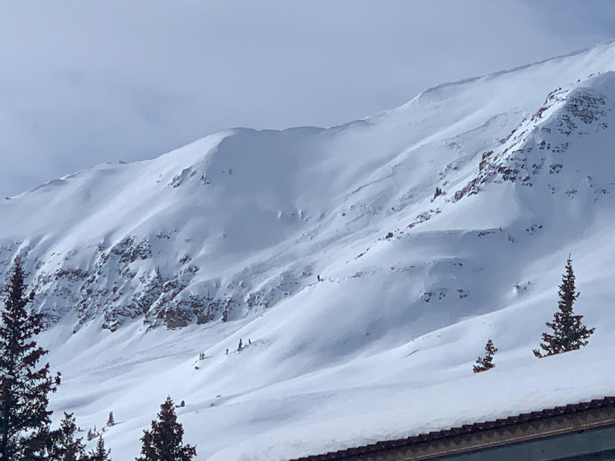
Aspect: North West
Elevation: 11,360′

Avalanches:

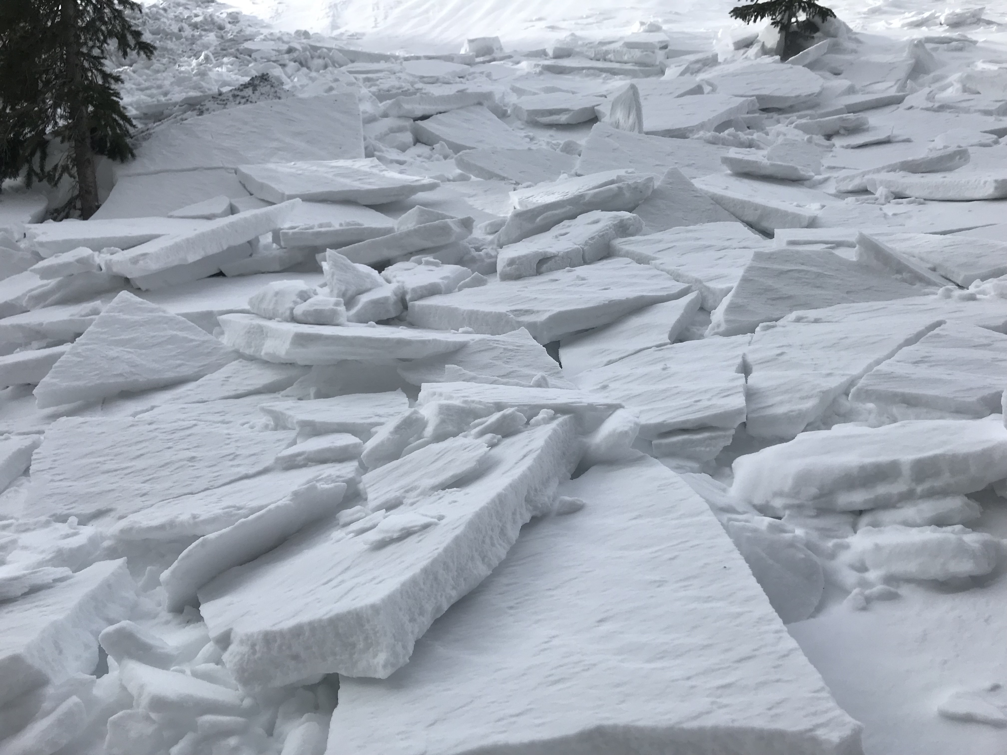
We have had numerous passes over the last several weeks in this piece of terrain with explosives work and ski cuts and had success affecting weak layers in the snowpack with these methods. We placed a 4# Air Blast on the far skiers right apron of Fredo’s and was able to affect the stubborn wind slab. The avalanche would be classified as HS-AE-D1-I.

Weather: Clear skies with strong winds from the NW and intense snow transport.

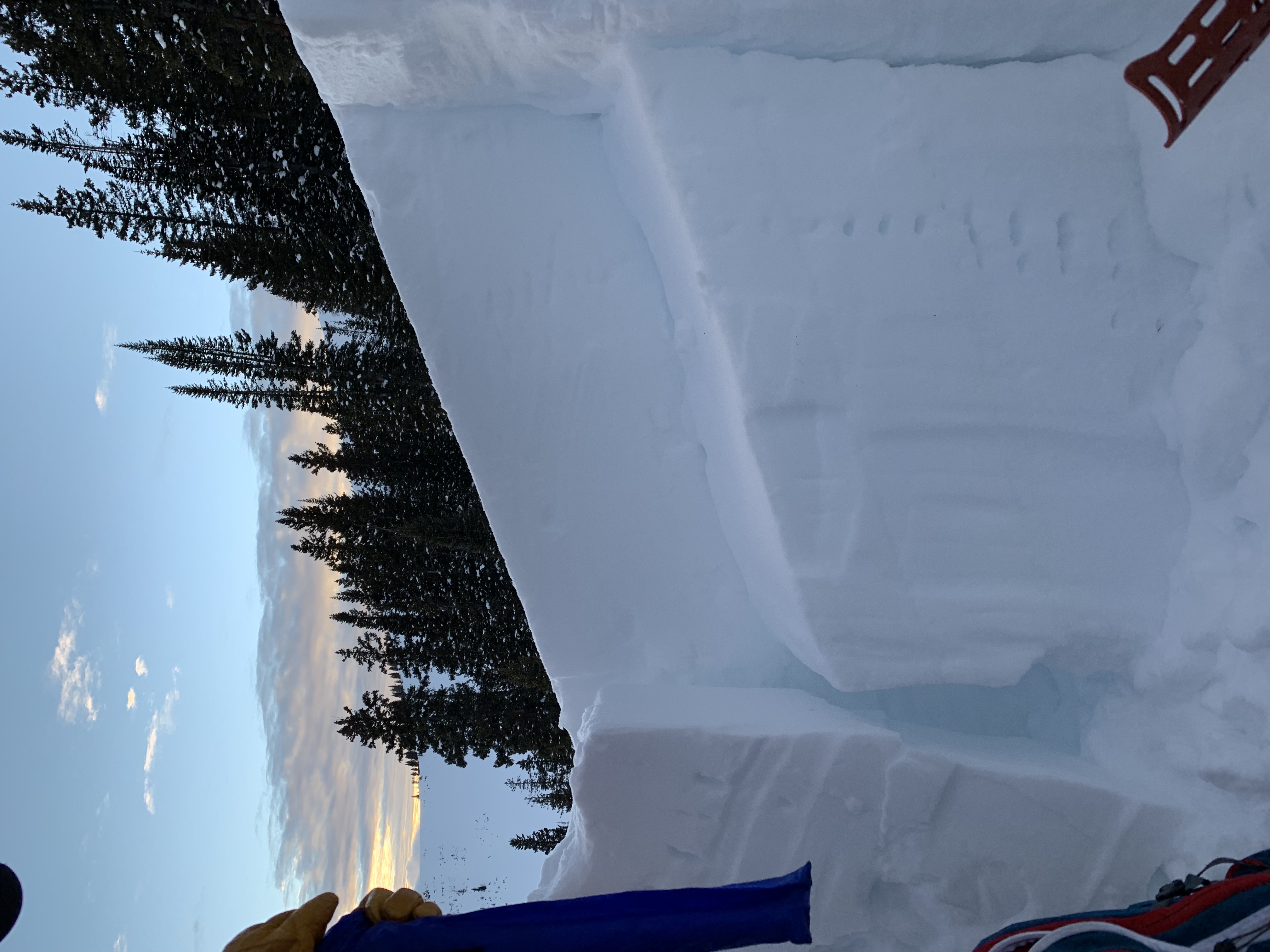
Snowpack: Witnessed evidence of wind affected slopes and stubborn wind slab. Any snow that had deposited in this piece of terrain from our previous storm seemed to have stiffened with the change in wind direction from the W-SW to the NW. The surface of the snow showed severe ripple marks and was extremely firm traveling across it on skis. It was fairly evident that the wind slab we were focusing on was stubborn and the likelihood of triggering would be low unless we used explosives.
Photos:

Mountain Weather for 11,000ft

CB Avalanche CenterWeather

Date: 01/29/2019

Dang, it is a cold morning but thankfully temperatures will come back up to comfortable levels during the day. The area is sitting between a ridge of high-pressure to our west and a low-pressure system over the Upper Plains and Great Lakes region. This setup will keep us in NW flow for another day or two. Daytime high temperatures will be on a steady rise for the next few days. A low-pressure system off the west coast will force the ridge out of the way by the weekend offering the next shot of accumulating snowfall on Saturday or Sunday.

  • Today

    High Temperature: 19 to 24
    Winds/Direction: 7 to 17, WNW
    Sky Cover: Partly Cloudy
    Irwin Snow: 0
    Elkton Snow: 0
    Friend’s Hut Snow: 0

  • Tonight

    Low Temperature: -1 to 4
    Winds/Direction: 5 to 15, WNW
    Sky Cover: Clear
    Irwin Snow: 0
    Elkton Snow: 0
    Friend’s Hut Snow: 0

  • Tomorrow

    High Temperature: 25 to 30
    Winds/Direction: 7 to 17, WNW
    Sky Cover: Clear
    Irwin Snow: 0
    Elkton Snow: 0
    Friend’s Hut Snow: 0

Irwin Cat Ski Obs

CB Avalanche Center2018-19 Observations

Location: Kebler Pass Area
Date of Observation: 01/28/2019
Name: IG

Subject: Irwin Cat Ski Obs
Aspect:
Elevation:

Avalanches:

Double on a stick popped windslab in Mikes pocket. 2 layers in the slab which formed Saturday and maybe late yesterday(?). OL Glade SS-AB-R2-D1-I U-01/26 (30cm x 20m x 80m) 2 windslabs pasted lee of tree fence

Weather: S1 with periods of S2 till 13:00. Then clearing SCT to FEW

Snowpack: Windslabs throughout our tenure. Some cracking with skis but no movement. Solid windboard up high in the UWW. Entrance to Sunset Left OL glade very stiff but supportable. Hollow feeling on
the actual windslabs which are obvious.
Photos:

Quick look BTL on west end of Emmons

CB Avalanche Center2018-19 Observations

Location: Kebler Pass Area
Date of Observation: 01/28/2019
Name: Eric Murrow

Subject: Quick look BTL on west end of Emmons
Aspect: East, South East, South
Elevation: 9,200′ – 10,500′

Avalanches:

Weather: Snow S1 with short periods of S2 during AM. Skies began became partly cloud by 2pm and snow tapered off, about 2.5inches new at 2pm.

Snowpack: Took a look at some easterly terrain near several natural avalanches that failed 1/25 or 1/126. HS at 10,400′ in rolling easterly terrain averaged around 160cm. On one East facing roll the early January weak layers were around 75cm down (was able to pick some rounding SH out of the interface), ECTX. This was likely the interface responsible for the nearby natural avalanches. Mid-December weak layer and early season basal weak layers continue to gain strength and round. Interfaces of interest in this deeper snowpack part of the forecast area are becoming the 1/15 and 1/21.

Photos:

Mountain Weather for 11,000ft

CB Avalanche CenterWeather

Date: 01/28/2019

Another “clipper” storm is passing through Colorado today from the NW. There is an associated cold front with this system that will help to squeeze the moisture out as it passes by. The Crested Butte area will largely be to the south of this system, but for today you can expect the possibility of a trace to 2 inches accumulation. There are light flurries showing up on the Irwin webcam early this morning. Expect temperatures to remain cool today and become frigid overnight. The rest of the week looks to be dry with the next projected storm to arrive on the weekend.

  • Today

    High Temperature: 12 to 17
    Winds/Direction: 10 to 20, WNW
    Sky Cover: Mostly Cloudy
    Irwin Snow: trace to 2″
    Elkton Snow: trace to 2″
    Friend’s Hut Snow: trace to 2″

  • Tonight

    Low Temperature: -5 to 0
    Winds/Direction: 5 to 15, WNW
    Sky Cover: Mostly Clear
    Irwin Snow: 0
    Elkton Snow: 0
    Friend’s Hut Snow: 0

  • Tomorrow

    High Temperature: 20 to 25
    Winds/Direction: 5 to 15, WNW
    Sky Cover: Mostly Clear
    Irwin Snow: 0
    Elkton Snow: 0
    Friend’s Hut Snow: 0

Irwin Cat Ski Obs

CB Avalanche Center2018-19 Observations

Location: Kebler Pass Area
Date of Observation: 01/27/2019
Name: IG

Subject: Irwin Cat Ski Obs
Aspect:
Elevation:

Avalanches:

None today in our Tenure. Natural off Ruby from yesterday or day before. see photo

Weather: BRK Skies turned to FEW by the end of the day with moderate solar radiation and some green
housing through thin clouds. Winds were calmer today than yesterday.

Snowpack: South got moist today as well lower elevation SW. Good quality skiing all day with no signs of instability. We have not been skiing the UWW and LEAN was the highest we got in the Westwall.

Photos:

Snow Profile on Ponytail Glades

CB Avalanche Center2018-19 Observations

Location: Kebler Pass Area
Date of Observation: 01/27/2019
Name: Travis Tucker

Subject: Snow Profile on Ponytail Glades
Aspect: South
Elevation: 11,530’

Avalanches:

Red Lady Bowl Ridge @ 12,200’ @ time unknown
C-CN-R1/D1.5-I
SZ Ridge / Terminus TR
.5x15x45m
Cornice dropped on windslab

Weather: FEW clouds
27*F
Light winds from the NW-W with stronger gusts

Snowpack: 27* Test slope
Photos:

AIARE 1 tours in Washington Gulch

CB Avalanche Center2018-19 Observations

Location: Crested Butte Area
Date of Observation: 01/27/2019
Name: Casey Graham

Subject: AIARE 1 tours in Washington Gulch
Aspect: North East, East, South East
Elevation: 10, 800

Avalanches:

Peak west of Painter boy mine, E face on the south end of the ridge. PS, R1 D2~300ft. crown, ran ~300ft, E facing slope.

Weather: Mod. W winds, Broken sky, no precip., cold temps most of the day with a high of -2degC

Snowpack: Coney’s Crews – Avalanche observed above TL on peak west of painter boy mine. PS size 2 ~300ft. crown, ran ~300ft, E facing slope. Wind loading observed on NE aspects BTL

Pit dug near Ridgeline in Coney’s – 10,800PS found over early season facets. NE aspect, near tree-line, 26 deg. slope angle, HS-138, layer of concern: buried facets down 75cm. CTN x2

Snodgrass: Pit dug ESE, 10,800ft, 12 deg slope angle, HS 115, CTN x2 ECTX
Photos:

Snodgrass-End of the Melt down

CB Avalanche Center2018-19 Observations

Location: Crested Butte Area
Date of Observation: 01/27/2019
Name: ADB

Subject: Snodgrass-End of the Melt down
Aspect: East, South East
Elevation: BTL

Avalanches:

Weather: Obstructed skies and calm.

Snowpack: Trees: supportive and stiff in the trees. Open areas near the Gothic road have developed patchy sun crusts.
No signs of instabilities observed.
In thick dense trees, watch out for hollow shallow snow around saplings, as I caught a tip on three saplings; fell sideways with face buried in snow for 5 seconds before clearing air path. Had to pop out of two Dynafit bindings. A quick adrenaline rush.
Photos:

Mountain Weather for 11,000ft

CB Avalanche CenterWeather

Date: 01/27/2019

A high-pressure ridge is to our west and a big low pressure is to our east, while Colorado sits under Northwest flow. The pressure gradient under this northwest flow will keep winds blustery in the alpine today. The clear sky this morning will start to increase with clouds throughout the day, ahead of a little moisture and a cold front moving in tonight. We may see a dusting of snow early Monday morning, then back to hanging out under the mostly dry northwest flow as we look into the start of next week.

  • Today

    High Temperature: 23 to 28
    Winds/Direction: 10 to 20, G 30 NW
    Sky Cover: Increasing clouds
    Irwin Snow: 0
    Elkton Snow: 0
    Friend’s Hut Snow: 0

  • Tonight

    Low Temperature: 10 to 15
    Winds/Direction: 10 to 20 NW
    Sky Cover: Mostly Cloudy
    Irwin Snow: 0 to 1
    Elkton Snow: 0 to 1
    Friend’s Hut Snow: 0 to 1

  • Tomorrow

    High Temperature: 15 to 20
    Winds/Direction: 10 to 20 NW
    Sky Cover: Mostly Cloudy
    Irwin Snow: 0 to 1
    Elkton Snow: 0 to 1
    Friend’s Hut Snow: 0 to 1