Zone: Southeast Mountains Route Description: Snowmobiled on various aspects to the headwaters of Cement Creek, up to 12,000 ft.
Observed avalanche activity: Yes Avalanches: More small wet loose activity today at all elevations, southern half of the compass. A few fresh cornice falls on Double Top to D1.5. A handful of small to large wind slabs that probably ran Friday above treeline. One deeper and fresher looking slab avalanche on a SE facing slope above treeline on Gothic Peak that ran sometime in the past few days. Weather: Warm and sunny most of the day. Clouds quickly increased to overcast from 3 to 4 p.m. Moderate ridgetop winds this afternoon were starting to drift snow. Snowpack: Still getting fairly consistent shooting cracks and remotely triggered mini slabs in creek beds below treeline on untrammeled shady aspects. Signs of instability diminished as I got higher in elevation, although I did get easy propagating results under a 2 foot slab on the Double Top Ridgeline (NE aspect, 11,600′). These instabilities are all on the sandbox layer, 18″ to 24″ deep, on average fist to fist+ hard and 2mm in size. Tried snowmobile cutting several hard wind slabs above treeline on small, supported features and the only result was me getting bucked off the sled.
Photos:
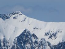
Large fresh-looking crown on SE side of Gothic Peak.
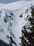
One of several wind slabs, SE aspect ATL. Likely ran Friday
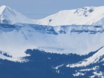
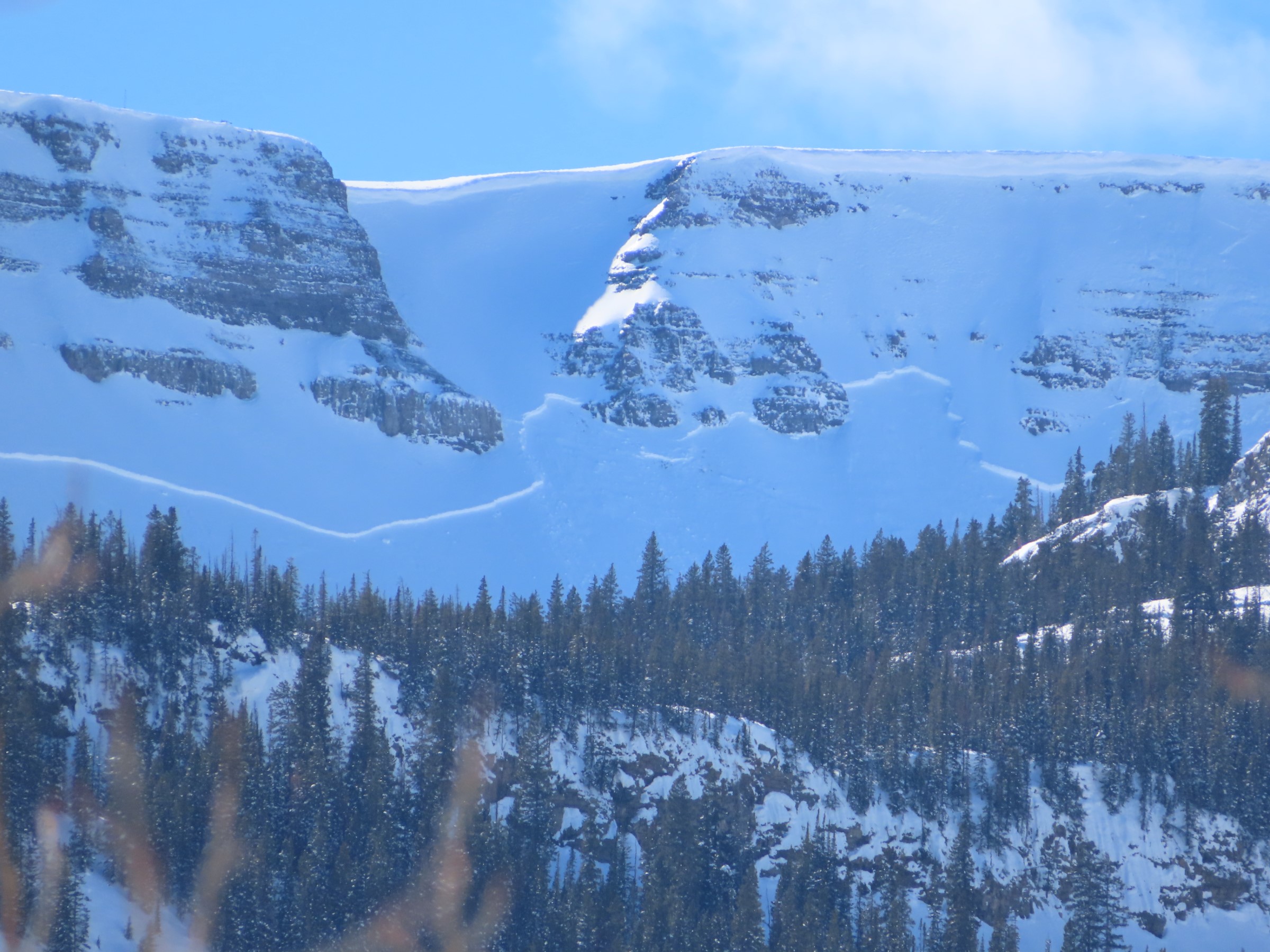
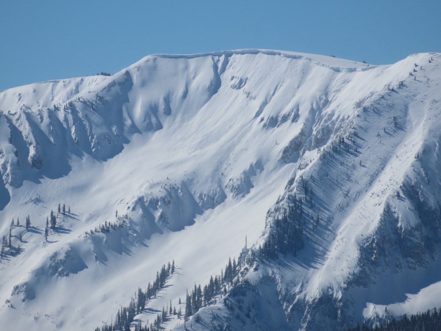
Better vantage of the Scarp Ridge slide. Some small wet loose in the background (Owen) and foreground (Peeler Peak)
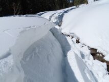
Remotely triggered mini persistent slab above a creek. 10,800 ft, ENE aspect.
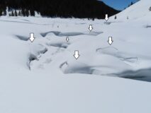
Annotated creek bed mini slab. Remotely triggered. 9,900 ft NW aspect
Shooting crack, NE aspect BTL
I’m fascinated by how these collapses often cross creeks over snow bridges.
Relative Size: R2 small Destructive Size: D2 – could bury, injure, or kill a person Avg. crown height (inches): Avg. width (feet): Avg. vertical run (feet):
Involvements
# of people caught: # of partial burials: # of full burials:
Additional comments: Could be a hard slab. Date estimated. Crown looks very fresh so it either ran at the end of the wind loading event (Friday night) or later. Crown also looks deeper than the other wind slabs noted on similar aspect.
Relative Size: R2 small Destructive Size: D2 – could bury, injure, or kill a person Avg. crown height (inches): Avg. width (feet): Avg. vertical run (feet):
Involvements
# of people caught: # of partial burials: # of full burials:
Observed avalanche activity: Yes Avalanches: These were largely unreactive to ski cuts but reactive to AE, most failing on the suncrust beneath this last storm cycle.
Field of Screams HS-AE-R1-D1.5-O FC (30cm x 30m x 200m)
Castle Valley Left HS-AB-R1-D1-O FC (70cm x 10m x 100m)
Castle Valley Right HS-ASc-R1-D1-O FC (20cm x 10m x 220m) ski cut at the top.
Estimated avalanche date: 03/12/2022 Number of Avalanches: 1
Location
Location: Lake Irwin (Robinson Basin, Owen, Ruby) Location Specific: Start Zone Elevation: NTL: Near Tree Line Aspect: W
Characteristics
Trigger: Skier Trigger modifier: Controlled Type: Hard Slab Failure Plane: Old snow
Size
Relative Size: R1 very small Destructive Size: D1- Relatively harmless to people Avg. crown height (inches): Avg. width (feet): Avg. vertical run (feet):
Involvements
# of people caught: # of partial burials: # of full burials:
Zone: Northwest Mountains Route Description: Upper Slate, traveled on easterly facing terrain to 11,600 ft.
Observed avalanche activity: Yes Avalanches: One very large (D3) persistent slab ran off of the east face of Peeler Peak today. Another large persistent slab ran below Scarp Ridge sometime last night or yesterday afternoon.
Spotted a handful of wind slabs that ran yesterday at higher elevations, D1 to D2, on SW to SE aspects.
A handful of small wet loose avalanches ran today near and below treeline. Observed slides on east to south aspects, sun was moving towards westerlies as my field day ended. Weather: Mild temps, few clouds, light breeze with no transport observed all day. Snowpack: Northwest winds affected the snow surface at all elevations here, with lots of soft sastrugi and obvious lobes of drifted slabs at all elevations. I was able to produce shooting cracks on some below treeline drifts where the slabs were thinner and softer. Near ridgetop, the slabs were meaty and dense and more stubborn. The persistent slab is about 3 to 4 feet thick here and evolving into a hard slab. Although we did not get any signs of instability on skis all day, we got one collapse while digging out a stuck sled. A quick test on a NE aspect at 11,000 ft produced propagating results on the dry spell layer after modifying the ECT into a “deep tap ECT”. No results under normal loading steps (ECTX). The layer is 4F- hard, 1mm in size under a 115 cm slab up to 1F hard.
Estimated avalanche date: 03/12/2022 Number of Avalanches: 1
Location
Location: Oh-Be-Joyful Basin Location Specific: Start Zone Elevation: ATL: Above Tree Line Aspect: E
Characteristics
Trigger: Natural Trigger modifier: Type: Hard Slab Failure Plane: Old snow
Size
Relative Size: R3 medium Destructive Size: D3 – could destroy a car, wood-frame house, or snap trees Avg. crown height (inches): Avg. width (feet): Avg. vertical run (feet):
Involvements
# of people caught: # of partial burials: # of full burials:
Additional comments: East face of Peeler. I did not see this very obvious crown there this morning, it was there this afternoon when I returned to the trailhead.
Estimated avalanche date: 03/11/2022 Number of Avalanches: 1
Location
Location: Peeler Basin Location Specific: Start Zone Elevation: ATL: Above Tree Line Aspect: NE
Characteristics
Trigger: Natural Trigger modifier: Type: Hard Slab Failure Plane: Old snow
Size
Relative Size: R3 medium Destructive Size: D2.5 Avg. crown height (inches): Avg. width (feet): Avg. vertical run (feet):
Involvements
# of people caught: # of partial burials: # of full burials:
Additional comments: Scarp Ridge below Legends. Crown looks very fresh. This avalanche first observed 9 a.m. on 3/12. It was not there around noon yesterday (3/11).
Relative Size: R2 small Destructive Size: D2 – could bury, injure, or kill a person Avg. crown height (inches): Avg. width (feet): Avg. vertical run (feet):
Involvements
# of people caught: # of partial burials: # of full burials:
Additional comments: SE to S face of Mineral Point. Wind slab.
Relative Size: R1 very small Destructive Size: D1- Relatively harmless to people Avg. crown height (inches): Avg. width (feet): Avg. vertical run (feet):
Involvements
# of people caught: # of partial burials: # of full burials:
Additional comments: Also a few smaller ones on SE and E aspects
Zone: Southeast Mountains Route Description: Pavement observations from HWY 135 and Taylor Canyon.
Observed avalanche activity: Yes Avalanches: Although skies were fairly clear, the thin cloud cover made distancing viewing a challenge. A couple of fresh-looking debris piles above Copper Creek and near WSC Peak on east and southeast aspects (vis was too poor to code with any confidence). Two natural avalanches on shady slopes below treeline in Taylor Canyon (D1’s , these looked older with a bit of refill so maybe from 2/23-2/25 avalanche cycle). One of the East Chutes on Park Cone had a reasonably fresh crown that propagated across most of its start zone (Park Cone is outside the CBAC forecast area but is similar to the shallower snowpack in the Southeast Mountains forecast area). Weather: Partly cloudy skies with blowing snow were observed at upper elevations. East through south aspects appeared to receive the brunt of wind-loading. Snowpack:
Photos:
A broadly propagating avalanche in an east chute on Park Cone. There was some refill on the bed surface so hard to nail down the timing.
Relative Size: R2 small Destructive Size: D2.5 Avg. crown height (inches): Avg. width (feet): Avg. vertical run (feet):
Involvements
# of people caught: # of partial burials: # of full burials:
Additional comments: Included in database as Park Cone is similar to the shallower snowpack in the Southeast Mountains. Size could have been creeping up on D3.
Zone: Northwest Mountains Route Description: As viewed from Gothic Peak
Observed avalanche activity: Yes Avalanches: A handful of D1 to D2 slab avalanches in wind drifted terrain that failed recently. Most looked like wind slabs failing within the storm snow. One appeared to be a large persistent slab below Scarp Ridge. See photos.
Relative Size: R2 small Destructive Size: D2 – could bury, injure, or kill a person Avg. crown height (inches): Avg. width (feet): Avg. vertical run (feet):
Involvements
# of people caught: # of partial burials: # of full burials:
Additional comments: Not sure if this is a thick wind slab or if it broke into old layers.
Relative Size: R1 very small Destructive Size: D1- Relatively harmless to people Avg. crown height (inches): Avg. width (feet): Avg. vertical run (feet):
Involvements
# of people caught: # of partial burials: # of full burials:
Additional comments: A few small wind slabs/cornice fall slides in 5th bowl
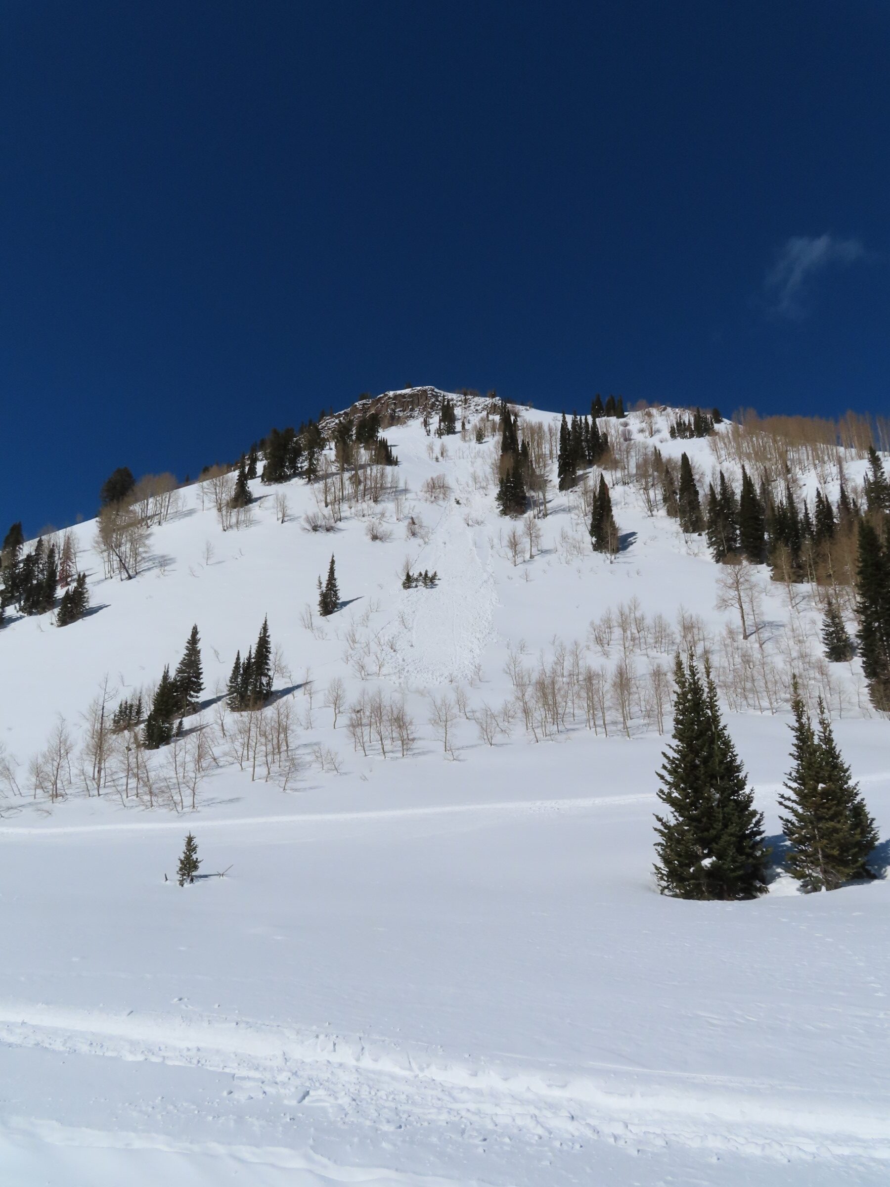
Zone: Southeast Mountains Route Description: Traveled on southerly aspects of Gothic Peak up to about 11,400 ft. Conditions worse than expected, bailed on our route plan and skied on NW, W, and SW aspects of Snodgrass instead.
Observed avalanche activity: Yes Avalanches: On wind loaded southerly aspects, we found sensitive wind slabs that we could easily trigger remotely failing on the 3/8 crust. Even from locations without any drifting or slab formation, shooting cracks would connect to a drifted feature and release it. We remotely triggered about 5 small wind slabs on drifted rollovers below treeline on S or SE aspects. Near treeline, we remotely triggered a large wind slab in the “mini spoon” that propagated 400 vertical feet above our location and crossed the whole slope; crown was 10″ to 24″+ thick. There was also a large natural that came out of the Spoon yesterday or last night, crown filled in.
With decent visibility, we spotted a handful of D1 to D2 slab avalanches that failed recently, recorded in a separate ob. Most looked like wind slabs failing within the storm snow. One appeared to be a large persistent slab below Scarp Ridge. Weather: Cold and windy. Large plumes of blowing snow off of the high peaks. Continuous drifting in valley floor. Mostly clear skies overhead, some hazy clouds lingering over the Ruby Range. Snowpack: About 5″ of settled storm snow over the 3/8 crust on southerly aspects. This crust formed during the one day of sunny weather in the middle of last week’s storm cycle, and I suspect there is some radiation recrystallization associated with it, given its behavior.
On NW aspects below treeline on Snodgrass, we got numerous collapses on the sandbox layer about 2 feet down. Some collapses required stomping, some went while breaking trail. We were in tight trees and collapses didn’t radiate very far. In windsheltered southwest facing terrain, we found stable conditions.
Photos:
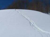
We remotely triggered a handful of wind slabs like this on cross-drifted terrain features below treeline.
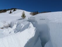
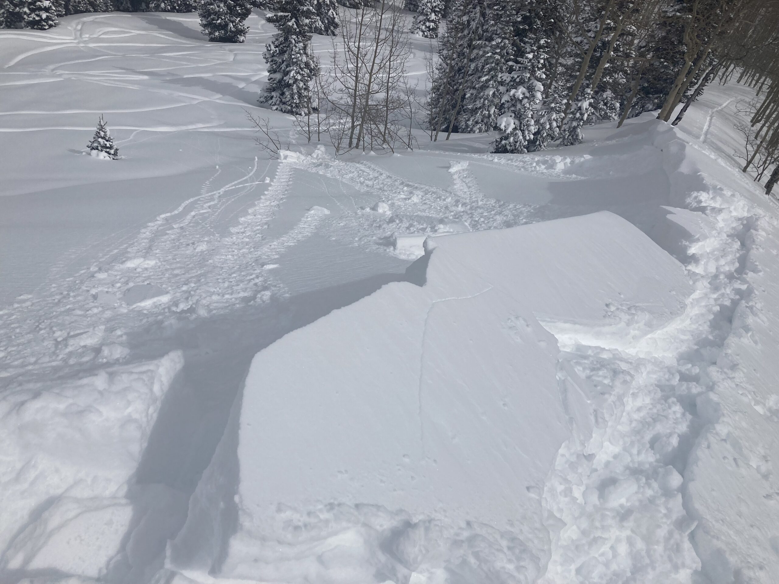
We remotely triggered this large slab avalanche from about 50 feet away. The failure propagated up slope about 400 vertical feet and pulled into the typical uptrack for Gothic.
Zoom in to the thickest part of the crown which appeared to be about 2 feet thick.
Looking down at the debris
A natural that came out of the Spoon early this morning or yesterday.
Relative Size: R2 small Destructive Size: D2 – could bury, injure, or kill a person Avg. crown height (inches): 16 Avg. width (feet): 200 Avg. vertical run (feet): 1200
Involvements
# of people caught: # of partial burials: # of full burials:
Additional comments: Mini Spoon. Remotely triggered from about 50 feet away. Pulled out onto the usual uptrack for Gothic.
Relative Size: R2 small Destructive Size: D2 – could bury, injure, or kill a person Avg. crown height (inches): Avg. width (feet): Avg. vertical run (feet):
Involvements
# of people caught: # of partial burials: # of full burials:
Additional comments: Debris pile in bottom of Spoon. Likely a wind slabs on SE or S aspect N or ATL.
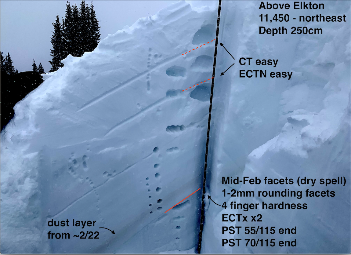
Zone: Northwest Mountains Route Description: Washington Gulch
Observed avalanche activity: Yes Avalanches: Visibility was poor so I did not observe a crown, but I spotted one fresh debris pile in a southwest gully on Gothic Mtn, D1.5. Weather: From noon to 4 pm, skies were mostly cloudy with light snowfall. Winds were light with moderate gusts up to 11,400 feet. Snowpack: I was snowmobiling for fun, but dug a quick profile on a northeast-facing slope at 11,450 feet – see photo. I found two interfaces, around 1 and 2 feet down, that produced easy, small-column test results but only produced tiny cracks on small test features while snowmobiling. The mid-February facet “drought layer” was down about 115cm below a stiff, cohesive slab. The weak layer from mid-February has improved a small amount in this area, but the stark difference in grain size and hardness with the overlying slab remains obvious in the profile wall.
Zone: Northwest Mountains Route Description: Lower Slate and Lower OBJ, various aspects traveling mostly below treeline.
Observed avalanche activity: No Avalanches: Had so-so vis into Redwell Basin and didn’t see anything notable. Maybe a couple of thin, small soft slabs on northerly below treeline. Weather: Wintery temps. Very light snowfall this afternoon. Light northwest winds were drifting snow near valley bottom. No transport higher up. Snowpack: About 6″ to 8″ new. Got a couple of large, rumbling collapses near the valley bottom on moderate angled NE aspects. Got one deep but localized collapse on a flat ridgeline at 11,000ft. These were all on the sandbox layer about 3 feet down. Got a few minor cracks and one shallow collapse that radiated about 40 ft on a steep south facing slope. This was on the 3/8 crust, which is a thin, soft crust that developed during the one sunny day between storms this week. There was about 6″ of storm snow above the crust; not sure there’s enough to produce a slab avalanche unless you were in a drifted location. We traveled on steep southeast aspects and a few east/northeast facing bed surfaces from the 2/23 cycle with no signs of instability on either.
Zone: Southeast Mountains Route Description: The old reliable, park at the bottom and look up at the mountain tour.
Observed avalanche activity: Yes Avalanches: A couple of small wind slabs on Whetstone. These were D1 to D1.5 in size. The only appeared to involve storm snow and didn’t propagate very wide. Probably ran yesterday during the stronger winds. ATL E to NE. Nothing else was observed while looking into those mountains.
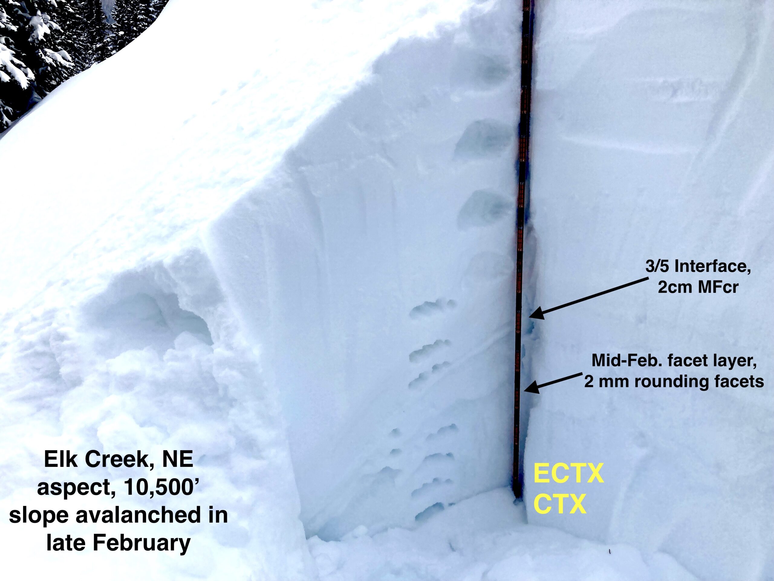
Zone: Northwest Mountains Route Description: Kebler Pass trailhead to Elk Creek, toured up ridge above the creek. 9,000 ft-10,500 ft
Observed avalanche activity: No Avalanches: No new avalanches observed on this tour. Very limited views into the surrounding upper elevation terrain. Weather: Broken skies and higher clouds gave way to low clouds, moderate snow and some wind around 2:30 as a squall moved in. Temps remained quite chilly, felt more like January than March. Snowpack: Walked around and jumped on a number of below tree line, northeasterly start zones, most of which avalanched early in the late February cycle. Generally, a soft 60-70 cm slab is resting on the bed surfaces in this zone. Bed surfaces themselves were a variably thick 1 finger hard crust capping 4 finger, 2 mm facets which do appear to be gaining strength. Very few signs of instability were observed underfoot or in a test pit other than 1 small leeward feature which had around 2ft of drifted snow and produced some small cracks in the new snow. No collapses or cracking were observed on the deeper weak layers on either slopes that avalanched or in-tact slopes.
Small cracking in the recently drifted new snow
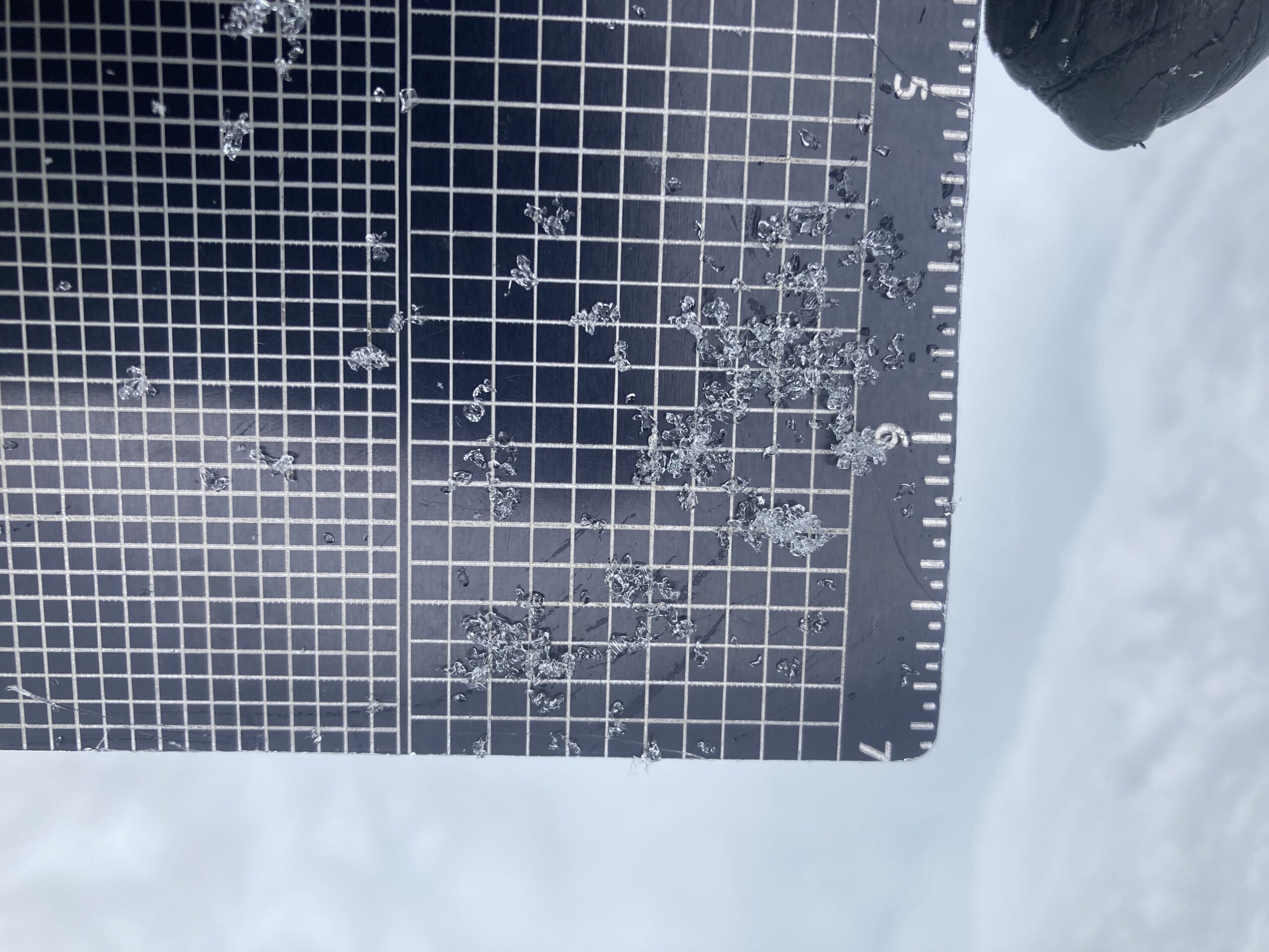
The “sandbox layer” is showing signs of rounding and sintering of grains.
Test pit from a slope that avalanched early during the late Feb cycle.