Mountain Weather January 15, 2015

CB Avalanche CenterWeather

Date: 01/15/2015

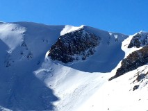
Another beautiful day is in store, with mild mountain temperatures, light winds, and plenty of sunshine the product of strengthening high pressure. Grab your powder tool of choice and climb above the inversions. We’re sitting at -12F in town this morning, but mountain temps should reach the 30’s today. High clouds will start to move in tomorrow ahead of a weak shortwave dropping in from the Northwest, which shows up Friday night into Saturday. Snow accumulations look to be a few inches at best.

Paradise Divide

CB Avalanche Center2014-15 Observations

LOCATION: Paradise Divide Area
DATE OF OBSERVATION: 01/14/2015
NAME: James Tonozzi
TITLE: edge of paradise must be heaven
ASPECT: North
ELEVATION: 11,000 to 8,500

AVALANCHES: R-2 D1 sliffing in new snow. no persistent slab activity in well protected true north. NEXT to a tree line but in the open on 1500 vert foot face.
observed some huge hang fire not in my drainage but ready to go. Thankfull to be in the North Paradise Zone with a little more depth and consistency in the pack. Not much wind in the last 5 days and in yesterdays snowfall.

WEATHER: Sunny and warm

SNOWPACK: Solid pack, recent 12-16 staying reasonably well behaved. True North aspect. some minor sluffing in the new snow . Skied on completely shaded north face on pitches up to 45 degrees. Saw some R 2 D1 sluffs in a convexity and below rock bands but super solid in my non cross loaded slice. Isolated a column at the top of face 120 CM deep . Had to beat the sheet out of it to get it to move.

Jan 14 Coney’s Ridge

CB Avalanche Center2014-15 Observations

Location: Crested Butte Area
Date of Observation: 01/14/2015
Name: Billy Rankin
Title: Jan 14 Coney’s Ridge
Aspect: East
Elevation: 11,000′

Avalanches: Old Avalanche way left in Bowl in classic convexity. A couple very small slides observed off West face Gothic just below ridgetop, A couple small shallow windslabs far end of Schuykil Ridge. Also small insignificant D1 or smaller.

Weather: Clear, high temps felt in the 20’s, strong solar radiation, light wind. Winds up high blowing plumes off Gothic peak and Baldy looked North, maybe North East.

Snowpack: Skied far left side of bowl, avoiding steeper convex roll. First turn of the ridge skis punched through a lot of the snowpack. On tenth turn my partner felt a small collapse right below the ridge that produced a 15′ wide crack. Skiing was feeling trap door ish with very weak mid pack. Windloading patterns on Gothic and Schuykil Ridge looked from winds out of the NNW.

Mountain Weather January 14, 2015

CB Avalanche CenterWeather

Date: 01/14/2015

The closed low that brought unsettled weather earlier this week is shifting south and east through Arizona and New Mexico today. Clouds have already cleared out as high pressure and dry northwest flow return to our region. The rest of the work week will bring sunny skies and a gradual warming trend in the mountains, while inversions set up in the valleys. A chance for snow returns this weekend.

Taylor Peak

CB Avalanche Center2014-15 Observations

Location: Brush Creek Area
Date of Observation: 01/10/2015
Title: Taylor Peak
Aspect: South East, South
Elevation: ~11,500

Avalanches: This hard slab avalanche appears to have stepped down around the cliff band. Observed 10th of January but expected failure occurring post late December cycle.

Weather: Sunny, 29 degrees F.

Uploads:

Mountain Weather January 13, 2015

CB Avalanche CenterWeather

Date: January 13, 2015

The center of the closed low is circulating along the Nevada/Utah border this morning. There’s not as much moisture on the back end of this system, but we’ll see some continued flurries today, with the Kebler and Paradise Divide areas favored. Cooler, dryer northerly flow will fill in as the low moves east, with dry weather through the rest of the week.

Wet Slab off of Cinnamon

CB Avalanche Center2014-15 Observations

Title: January Wet Slab
Location: Paradise Divide Area
Date of Observation: 01/10/2015
Aspect: South West
Elevation: 11500- 10000
Weather: Sunny, warm some clouds

Avalanches: Wet Slab off Cinnamon ran from ice cliffs to valley bottom. 8-15 inch crown ran approximately 1500 feet and left debris at “valley of Death” 20 feet high. Appeared to be 1-2 days old.

Snowpack: Prolonged High Pressure. Facets on the North…. Melt Freeze on the Solar aspects

Uploads:

Upper Slate River and Washington Gulch area

CB Avalanche Center2014-15 Observations

Location: Paradise Divide Area
Date of Observation: 01/11/2015

Weather: Snowfall exceeded the forecast, picking up 15cm (6″) by the end of the day, yahoo! West winds drifted the new snow as it fell.

Snowpack: 2 significant collapses on West aspects, both failing on the Dec 13 faceted interface. One slightly South of west, a second slightly North of west. On the second one, there was no old sun crust under the new snow and the slab was 4F to F+ hard, but even with the slab as not stiff as it was, it was still able to propagate ~70′ across a small 36 degree roll (see photo). Not that the Jan 11th snow changed the load on the Dec 13th layer to a great extent yet, but it’s a good reminder that as the snow loads grow, so will the distribution of the persistent slab problem, to include the weaker/shallower areas on the sunny side of the compass.

Mountain Weather January 12, 2015

CB Avalanche CenterWeather

Date: 01/12/2015

Crested Butte will hang in the balance between two storms today with little accumulating snow. Our atmosphere is currently primed with warm moist air, but this air needs a disturbance to help create snowfall. A low pressure trough is over Utah today and forecasted to swing south of Colorado tonight while forming a closed low. This will put us under southwest flow as we began to see this closed low affect our area tonight and tomorrow. With so much moisture in the air we could see high snowfall accumulations or the closed low could track further south and leave us skunked. This will be an interesting system to watch play out as either way our best guess forecasted snowfall numbers will likely be off. By Wednesday a flat ridge begins to build and we’ll see dry weather through the remaining week.