Wet Avalanches Co Road 742 Taylor Park

CB Avalanche Center2014-15 Observations

LOCATION: Cement Creek Area
DATE OF OBSERVATION: 03/18/2015
NAME: Havlick
SUBJECT: Wet Avalanches Co Road 742 Taylor Park
ASPECT: North, North East, North West
ELEVATION: BTL


AVALANCHES: several wet loose and wet slab avalanches reported sliding over CO Rd 742 to Taylor Park. Some of these slides slid past the centerline and required cars to slow and drive around in opposite lane. Rain and warm temps were falling when the slides reportedly slid between 11-2pm on 3/18.  Broken trees seen in debris.

WEATHER:

SNOWPACK:

UPLOADS:

Wet avalanches near town and wet snow at Irwin

CB Avalanche Center2014-15 Observations

LOCATION: Crested Butte and Kebler Pass Areas
DATE OF OBSERVATION: 03/19/2015
NAME: Zach Guy
SUBJECT: Wet avalanches near town and wet snow at Irwin
ASPECT: North East, East, South East, South, West
ELEVATION: 9,000 to 12,000 feet.


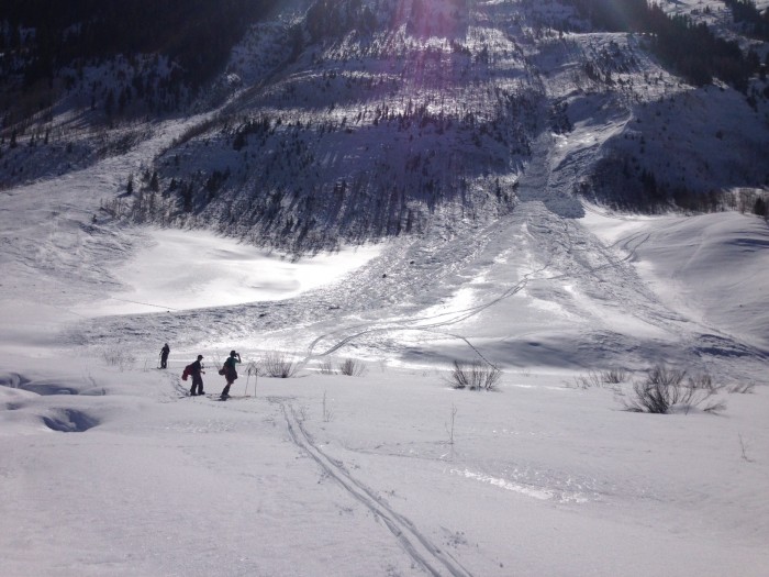
AVALANCHES: About 5 new wet avalanches ran yesterday or the day before on Gibson Ridge’s ENE face near town, below treeline. Some were slabs, some were wet loose, and all gouged to the ground, ranging from D1.5 to D2. WS/WL-N-R2-D1.5/2-G
Several very small wet loose and blocks of slab ran today above banks of Coal Creek, NE aspects BTL. Harmless in size and no more than 8 feet of propagation.

WEATHER: Clouds increased from few to broken through the day, with a short period of graupel in the afternoon. Temps rose to 39 degrees at 10k.

SNOWPACK: 2″ of new snow insulated wet snowpack from much of a refreeze last night. On Southeast, South, and West aspects at Irwin from 10k to 12k elevation: Boot penetration was waist deep and/or to the ground from mid-morning to mid-afternoon, with wet grains through the entire snowpack. Ski pen deteriorated through the day, changing from fully supportive to punchy knee deep or deeper by the afternoon.
Stability tests producing sudden collapse failures on facet layers above and below the February 20th crust, about 40 to 50 cm deep, on both SE and W aspects near treeline. Water pooling at this crust, which was very wet.

UPLOADS:

Mountain Weather March 19, 2015

CB Avalanche CenterWeather

Date: 03/19/2015

The chance for light snowfall will return today as another northwest shortwave phases with moisture funneling in from the southwest. We are on the western edge of this interaction, so don’t expect any significant accumulations. Thankfully, any precip should fall as snow today as last night’s cool front left colder air in its wake. Clear and dry weather return on Friday and Saturday before another weak system arrives on Sunday.

Skier triggered wet slabs in Climax Chutes

CB Avalanche Center2014-15 Observations

LOCATION: Crested Butte Area
DATE OF OBSERVATION: 03/18/2015
NAME: Public
SUBJECT: Skier triggered wet slabs in Climax Chutes
ASPECT: North East
ELEVATION: Below treeline

SNOWPACK: Skier triggered wet slab in Climax Chute yesterday. Middle to lower elevation of the chute.

Skier triggered wetslab in Climax Chutes near Slate River

Skier triggered wetslab in Climax Chutes near Slate River

Large Wet Loose Avalanches in Evans Basin

CB Avalanche Center2014-15 Observations

LOCATION: Crested Butte Area
DATE OF OBSERVATION: 03/18/2015
NAME: havlick
SUBJECT: Large Wet Loose Avalanches in Evans Basin
ASPECT: East, South East
ELEVATION: 9000-10000


AVALANCHES: Several large wet loose avalanches gouging down to ground below E-facing cliff bands. Entrained quite a bit of snow, pushing size 2 range. not quite wet slab, but did propagate horizontally a bit more than the classic triangular shaped wet loose activity.

WEATHER: overcast, scattered rain and snow showers. warm temps, light west winds

SNOWPACK: Quite warm, unconsolidated snow, punchy. melt water continues to advance, but quite variable, from full depth in shallower areas to 6-10″ in others.

UPLOADS:

Mountain Weather March 18, 2015

CB Avalanche CenterWeather

Date:

Warm and moist air is being drawn from the low pressure system today as it moves inland from Baja. A shortwave from the northwest will provide cooler air and an increased chance of snowfall this afternoon into tomorrow, althoughy accumulations look to be light. The rain/snow line will hover near 9,500 to10,000 feet today and start to lower overnight. Conditions will dry out by Friday and Saturday.

Wet slab avalanches

CB Avalanche Center2014-15 Observations

LOCATION: Kebler Pass Area
DATE OF OBSERVATION: 03/17/2015
NAME: Zach Guy
SUBJECT: Wet slab avalanches
ASPECT: East, South East
ELEVATION: Near/ Above treeline


AVALANCHES: Explosives triggered one wet slab, about 200 feet wide and 1 foot deep on a SE aspect near treeline. WS-AB-R2-D2-O

Second hand observations:
1)Wet slabs on skiers right of the Lady? Maybe Coon too? Hard to say, but looked like 2x D2 in Coon, maybe 40 m wide? Roughly the same in the Lady with a second pocket on the lower bench.
2.) Wet slab avalanche on an East aspect of Whetstone Mtn.

WEATHER: High of 52F at 10k. Light winds. Few clouds.

SNOWPACK: Ski pen increases from the top 5 cm late morning to nearly full depth by the afternoon. Around 3 p.m., we skier triggered one shooting crack on a SE aspect at 11,800 ft,  10 feet wide and about a foot deep, failing on wet grains. The slab moved downhill 6″ but stopped.

UPLOADS:

White Mountain

CB Avalanche Center2014-15 Observations

LOCATION: Crested Butte Area
DATE OF OBSERVATION: 03/17/2015
NAME: Kirk
SUBJECT: White Mountain
ASPECT: East
ELEVATION: 13401


AVALANCHES: N/A

WEATHER: Bluebird Morning temp at @ 7:15 23F light wind from the north

SNOWPACK: Solid as a rock .. spring supportable . 10:30 am Due East was good to go from the top all way to bottom . lower elevations were getting soft much later could be hating it .

UPLOADS:

Mountain Weather March 17, 2015

CB Avalanche CenterWeather

Date: 03/17/2015

Spring Break 2015 remains in full effect today, with mountain temps climbing from 30’s this morning to the high 40’s or low 50’s. The large scale weather pattern begins to change this afternoon. The low pressure system that has been parked off of Baja for the last week will move inland, bringing warm, moist air overhead. A shortwave dropping from northwest tonight will bring more lift and colder temps to help kick off the potential for snowfall. Additional energy and moisture will boost the chance for snow Wednesday night into Thursday. This system is complex and we might get surprised, but it doesn’t look too exciting for snowfall accumulations,

Natural wet loose avalanches

CB Avalanche Center2014-15 Observations

LOCATION: Kebler Pass Area
DATE OF OBSERVATION: 03/16/2015
NAME: Zach Guy
SUBJECT: Natural wet loose avalanches
ASPECT: Various
ELEVATION: up to 12,000 ft.


AVALANCHES: New loose wet avalanches (D1 in size, last 48 hours) on NE and E aspects near and above treeline in Peeler Basin and Anthracite Range, and a northwest aspect below treeline near Cement Creek (D1.5).  See Ian’s ob of new wetslab in Peeler.

WEATHER: Temps reached into 50’s at 10k. Light wind to moderate winds. Few clouds

SNOWPACK: Free water is on the move. Refreeze was about 6″ overnight at 11k. Boot pen to the ground through wet grains in a number of slopes facing SE to W near/above treeline.

UPLOADS: