Date of Observation: 11/07/2015
Subject Skier Triggered Slab Avalanche on Baldy
Elevation: Above Treeline
Avalanches: On a north facing bowl on Mt Baldy. SS-AS-R2-D2-O

Photo credit Austin Gibney


Avalanches: On a north facing bowl on Mt Baldy. SS-AS-R2-D2-O

Photo credit Austin Gibney


Avalanches: SS-N-R2-D1 noted in the saddle between Ruby and Owen. Looks to have run mid storm. Some debris piles noted on the East faces of Ruby and Owen looks like dribblers that also ran midstorm.
Weather: Sunny, hot! +4 at 11 am at 12,000′. Calm winds becoming light from the West afternoon.
Snowpack: Average about a foot of snow, rapid settlement throughout the day. Intermittent old snow either 4-6 cm of 1-2mm facets or an old crust. Mostly just the new snow. Near surface facets noted in the cold morning, gone by afternoon. Full snowpack was moist by 2 pm.
Snowpack: Last 24 hours: 6″ at .5″ SWE
Storm total: 18″ at 1.45″ SWE
Density inversion 4″ below the surface. Gusty WNW winds and 3-4′ drifts.
Avalanches: Skier triggered one soft slab on a NE feature above treeline that failed on the storm interface about 15″ deep, on faceted snow. Small in destructive size. SS-ASc-R1-D1-I. See photo.
Weather: Light snowfall continued all day, with pulses of moderate snowfall. Calm winds. Overcast skies.
Snowpack: Storm snow depths increased from 10″ at 10,000 ft to 20″ at 11,700 ft in a NE facing bowl. Fist hardness and right-side up, but cohesive enough to form a soft slab. No signs of instability where the storm snow fell on dirt. At 11,300 ft, we first encountered old snow layers at the bottom (1mm facets), and immediately began seeing shooting cracks (~5 feet in length) and getting soft collapses. When we ventured to SE facing slopes which held melt-freeze crusts at the bottom of the snowpack, we did not see any signs of instability, and the new snow appeared to be bonded well to the storm interface. No signs of significant wind transport, but we stayed low in the bowl and avoided the higher, potentially wind-loaded ridgelines.
Avalanches: 2nd hand report to CBAC of a wind slab triggered while climbing on the east face of Mineral Point. The crown was roughly 1 foot deep and estimated 20-40 feet wide, on a windloaded terrain feature, D1 in size but large enough to carry you over cliffs
Avalanches: Saw a previously triggered (assumed to be natural) wet loose/slab on a SSE aspect R1 D1 with a crown around 3-4 inches. Also skier triggered a wet loose R1 D1 on a SW slope with exposed rock nearby.. Slide started small but pinwheeled and picked up snow on 5-10cm crust on the ground.
Weather: Sunny and breezy with clouds increasing during the day. Little snow transport witnessed.
Snowpack: Snowpack is largely on slopes that were loaded from the storm earlier this week with strong NW winds. Many windward slopes blown clean of snow. The base of the pack on solar aspects ranges from crusts on the ground to no snow at all. This was topped with a dense wind slab of varying thickness dependent on the slopes’ relation to the wind. The small dusting of new snow sat on top.
Avalanches: No signs of instability except for very shallow and isolated cracking in areas with recent wind drifting (only a couple inches deep) Not much in the way of avalanche concerns.
Weather: Few clouds. Moderate to strong ridgetop winds from the NW, but no snow transport.
Snowpack: Continuous snow coverage begins around 11,000 to 11,500 feet, and is spottier on south aspects. Total snow depth is generally less than 10″, but up to 2 -3 feet in windloaded areas. On southerly aspects, the snowpack is comprised of one or multiple stacks of crusts, with 1-2mm facets below or between in some locations. The surface became moist today. On northerly aspects, the snow surface is a mixed bag of wind crusts, sastrugi, dense rounds and near surface facets, all showing signs of surface faceting. The snowpack is mostly rounded and relatively dense, except in the shallower, wind protected areas which have 1 mm facets throughout.
Avalanches: Observed a previously triggered point-release on a W – NW aspect near WSC bowl on Baldy. Likely occurred 10/23.
Weather: Warm and clear during the days with clouds increasing Sunday.
Snowpack: Most snow accumulation is around 11,000 feet and above. Little avalanche potential otherwise as there is simply not enough snow to form slabs. The exception is up high in very windloaded areas. A snowpit around 12,700 feet on a E-facing windloaded slope (Treasury) showed a pack of 110 cm with uniform layering . ECTN. Typical mixed bag of conditions elsewhere where snow had accumulated with suncrusts, wind crusts, and dry snow in the suspect areas. Did find basal crust on rocks under dry snow on N-facing slopes around 11,000.
Weather: Clear skies and a solid refreeze however only 24 hours after major rain event which led to serious sluffs/point release stepping down and triggering wet slabs throughout Queens basin
Snowpack: Two inches of melt freeze on top of some pretty wet snow – the rain event did a number on what was left.
Issued 4/6/15 by CBAC
Spring season is a great time of the year to get into the mountains and generally offers better stability and more manageable avalanche problems for backcountry travelers. Â However, avalanches conditions can still be dangerous during spring, and there are several kinds of problems you should continue to monitor and assess in you springtime adventures.
-Storm instabilities
Spring snowfall will usually fall on some form of crust.  These surfaces do immediately bond well.  Anytime a slab of new or windblown snow forms, expect touchy conditions during and shortly after the storm.  New snow becomes especially sensitive as the sun comes out immediately after the storm and quickly consolidates into more of a storm slab.  Expect leeward and crossloaded features at higher elevations to hold thicker and more sensitive windslabs  following a storm with moderate or strong winds.  These kinds of instabilities are generally short-lived during the springtime, but can last for several days after the storm on shaded aspects or higher elevations. The best strategy is to monitor how much snow accumulates during a storm and ease into small and manageable terrain until you’ve assessed how large and how sensitive new slabs are.  Be wary of windloaded slopes and avoid heavily windloaded features following a significant storm.  The Schofield Pass SNOTEL, which is northwest of town, and the Butte SNOTEL, which is on Mt. Crested Butte, are local remote snow sensors that update hourly.  Storm or wind slabs are most problematic over consequential terrain with cliffs, gullies, long vertical, or rocks and trees.
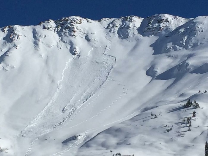
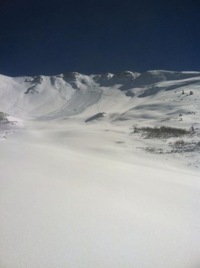
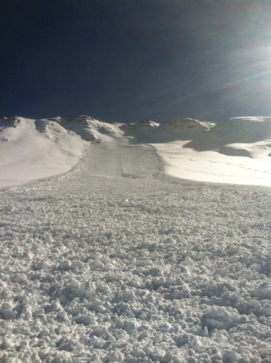
-Wet avalanches
When the sun (or rain) comes out after a spring storm and moistens the new snow, loose wet avalanches become frequent on any slope steeper than 35 degrees, and these point releases typically fan out and entrain all of the new snow down to previous crust layers.  These are usually small and predictable, but can carry significant mass after a large storm or in terrain with significant vertical relief.  They can also gouge deeper and grow larger entraining the full snowpack during prolonged warm-ups.  Wet slabs can be a larger and more dangerous problem. These are caused by liquid water percolating to and compromising the strength of buried weak layers.  This year, our snowpack is about a month ahead of schedule, meaning our April avalanche problems are more typical of May problems.  Most slopes facing east through south through west, as well as lower elevations that face north, have seen water run through the entire snowpack and have already been delivered the dry to wet “spring shock”.  These slopes saw a wet avalanche cycle in mid-March.  A number of these slopes have matured into a stable, spring snowpack, but it is difficult to identify which ones could still be harboring the threat of a wet slab.  Northerly facing slopes near and above treeline have seen less, if any, meltwater, and still primed for wet slab activity when temperatures and the higher sun angle turn on the water factory.  Last year, these slopes began their wet slab cycle around late May to early June.  The size of wet slabs failing on deeply buried weak layers will be likely be large at these elevations.  Wet slabs are most likely to occur during prolonged warm-ups and/or following multiple nights without a good refreeze.  If we see a dust-on-snow event, this will expedite surface warming.  Wet avalanche danger is usually lower in the morning and rises through the day. The best strategy is to exit avalanche terrain early during warm, sunny days or avoid it during rainy days.  Monitor how well the snow surface refroze overnight, and time your descent so that you are riding in a couple inches of supportive corn skiing, rather than punchy, trap-door snow or ankle deep slushy snow.  Look for evidence of recent wet avalanches on similar slopes to clue you in to dangerous conditions.  Monitor mountain temperatures from these weather stations and expect cloudy nights to prevent a better refreeze.
-Cornice Falls
Springtime is the season that large cornices that have been growing all season begin to weaken and fall.  These can also be triggers for slab avalanches.  Cornices tend to break wider than expected.  Give cornices a wide berth if you are traveling along a corniced ridgeline, and limit your amount of exposure climbing underneath cornices, especially during the peak of warming.
The CBAC will continue to monitor the snowpack and post updates to our website and our facebook page if conditions warrant.   The CAIC will issue statewide updates on Mondays, Wednesdays, and Fridays into the spring season. Â