Mountain Weather 12/9/15

CB Avalanche CenterWeather

Date: 12/09/2015

Breezy but dry conditions will persist for the next two days as the storm track and jet stream remains to our north. Weak disturbences embedded in northwest flow will bring increased cloud cover tonight and tomorrow but sno w is unlikely. A Pacifc trough impacts our region on Thursday night into Friday. A slow moving cold front, along with jet and orographic support will combine to produce a decent shot of snow and wind to carry us into the weekend. Accumulations are roughly looking like a foot in favored locations, with half of that or less closer to town.

Mountain Weather 12/08/2015

CB Avalanche CenterWeather

Date: 12/08/2015

A weak embedded wave under northwest flow will bring an increase in cloud cover and maybe a few snow flurries in our peaks today. We’ll see dry conditions follow suit until another weak disturbance brushes to our north Wednesday night. The heavy hitters arrive on Friday into the weekend, but models are showing some disagreement on how to handle this incoming Pacific trough. Details to come later this week.

Weak snow on Mt. Emmons

CB Avalanche Center2015-16 Observations, Snow Profiles

Location: Crested Butte Area
Date of Observation: 12/07/2015
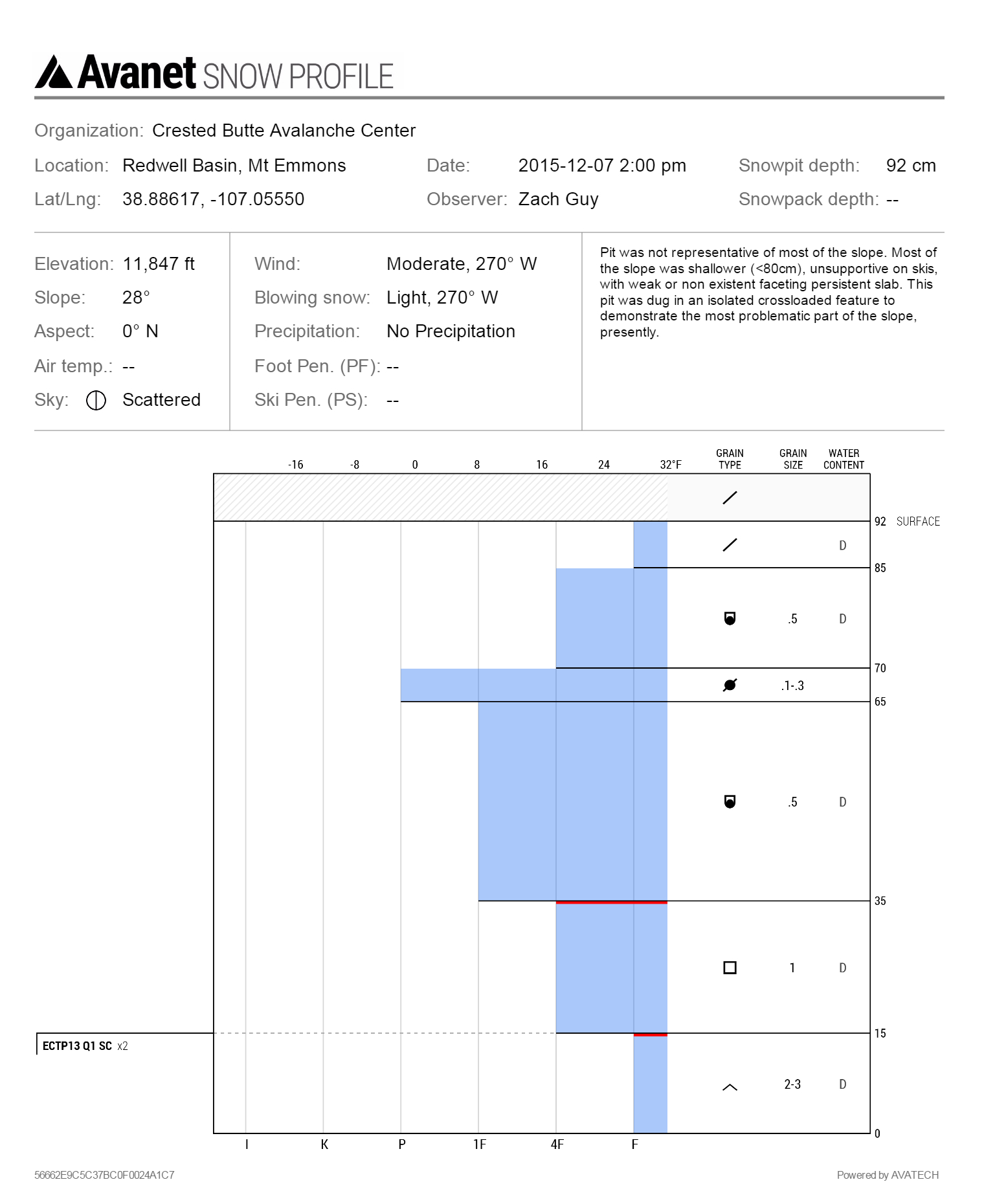
Name: Zach Guy
Subject: Weak snow on Mt. Emmons
Aspect: North, North East, East, South East
Elevation: 9,500 – 12,000 ft

Avalanches: We triggered cracking and a very small windslab avalanche, 4″ deep x 15 feet wide, on several windloaded rollovers facing SE. Also some small cracks where the persistent slab structure was shallow (<20 cm) but stiff from wind.
Weather: Scattered, thin clouds. Moderate to strong westerly winds with light snow transport at ridgetop. Mild temps, no precip.
Snowpack: In summary, widespread weak and faceted snowpack on all aspects, with decaying and unreactive persistent slabs except in isolated, heavily windloaded features. See video
Below treeline: Snowdepth is less than 30 cm, entirely faceted, fist hardness on all but southerly aspects. Ski pen to the ground. Most southeast through southwest aspects are bare, or hold shallow stacks of melt-freeze crusts with varying degrees of faceting between crusts.
Near treeline on N to E aspects: Snowdepth ranged from 40 to 80cm, with fist hard facets in the lower half, and in windloaded areas, faceting slabs in the upper half (4F hardness). No results in snow pits. Ski pen was trap-door, nearly to the ground.
Above treeline on N to NW aspects: Predominately thin snowpack due to wind erosion, <60 cm, and faceting throughout, with ski pen near the ground.  Isolated and discontinuous pockets of supportive snow with 1F to 4F faceting slabs over softer facets, similar to near treeline, but stiffer and thicker in the more heavily windloaded features.  In one crossloaded gulley, the snowpack was 100 cm deep and showed propagating test results on depth hoar near the ground.  On SE aspects ATL, we found thick, supportive crusts on steep (~40*) slopes, and an entirely faceted snowpack with thin, breakable midpack crusts as the slope angle lowered to mid 30’s. No slabs on this slope.

Above treeline, North aspect on Mt. Emmons
Near treeline, NE aspect on Mt. Emmons.
IMG_5340
More bare slopes than snow covered on SE, S, and SW aspects below treeline, looking toward Schuykill Ridge, Anthracite Mesa, and Snodgrass.

Mountain Weather

CB Avalanche CenterWeather

Date: 12/07/2015

Today’s weather will be similar to yesterday with strong valley inversions this morning, slowly easing as the day goes on. High clouds will filter into the area throughout the day as weak ripples in the jet stream bring high level moisture overhead and gusty winds at mountain top level. The weekend’s storm continues to evolve but continue to see model agreement that potential snowfall could range between 10-20” accompanied by strong winds. Each day, and each model run we will see details on timing and strength clarify, so stay tuned.

Poverty Gulch Dec. 6

CB Avalanche Center2015-16 Observations

Location: Paradise Divide Area
Date of Observation: 12/06/2015
Name: Dustin Eldridge
Subject: Poverty Gulch Dec. 6
Aspect: North, North East, East, South East
Elevation: 9,600-12,000

Avalanches: Just saw the previously mentioned point-releases.
Weather: Cold start at the TH in the morning but temps quickly warmed as we climbed out of the valleys. Saw multiple point-releases from E-facing rockbands. West and Southwest winds became gustier in the afternoon and moderate snow transport was occurring on ridgetops.
Snowpack: Started climbing up E-facing slopes below treeline and found surprisingly deep snowpack in areas (up to 120 cm). Around 15-20 cm of storm snow sat on a very firm crust and snow was easily sliding on this interface. No evidence of slabbing or cohesion in the storm snow at any elevation. The N-NE snowpack around 11,600 showed a burly pack averaging around 150 cm of snow. The lowest spot found was 70cm in a more wind affected area and the highest was over 220 cm. Storm snow was 20 cm and more in this area and elevation. Snowpack felt rather consolidated and uniform throughout. The exception was on more westerly facing slopes that received a stiff wind slab from recent NW winds. Below this was 5-15 cm of softer snow with another stiff slab below.

Mountain Weather

CB Avalanche CenterWeather

Date: 12/06/2015

Our orographic popcorn showers quickly ended shortly after sunset last night in the upper Gunnison River basin, and strong radiational cooling dropped our overnight lows in the valleys to near or below zero, while areas above 10000 feet sit in the 20s at 5am. Sunny skies will dominate today, but look for breezy conditions above treeline. With pretty good model agreement for the week ahead, we can all look forward to a pattern change and significant snow accumulations toward the end of the work week. Yes. The double “S” word…Significant snow… Bears some watching still, but looking promising.

Axtell

CB Avalanche Center2015-16 Observations

Location: Kebler Pass Area
Date of Observation: 12/04/2015
Name: Ian Havlick
Subject: Axtell
Aspect: North, North East
Elevation: 9-11000

Weather:Increasing clouds throughout day, no winds, pleasant temperatures in shade
Snowpack: HS ranged between 45-65cm on tour toward Green Lake. Lots of pits and ECT showed no propagation potential and lots of slabs breaking apart during moderate and hard loading steps. Most concerning could be new thanksgiving snow (10cm) which are stiff wind crusts with abrupt soft/faceted snow below. Wind crust could be stiff enough to carry large load (1.5″ swe) but any slide seems that it would scour to ground with so much weak (2-4mm) depth hoar/facets.

Mountain Weather 12/05/15

CB Avalanche CenterWeather

Date: 12/05/2015

A fast moving trough and associated cold front are passing over the Elk Mountains this morning, bringing light snowfall and colder air in its wake. Winds are light out of the southwest early this morning, and will swing around to the northwest as this system passes, spurring additional orographic snowfall. A few more inches could accumulate by the afternoon. A short-lived ridge clears and dries out the atmosphere tonight, before zonal flow sets up next week, bringing a series of disturbances, the first of which arrives on Tuesday morning.

Mountain Weather 12/04/15

CB Avalanche CenterWeather

Date: 12/04/2015

We will see another mild day under warm, southwest flow before a fast moving Pacific trough arrives tonight. Light snowfall kicks off after midnight. We should see 1″ to 3″ before high pressure begins to rebuild on Saturday afternoon. Paradise Divide and Schofield Pass look to be favored for this system.

Baldy

CB Avalanche Center2015-16 Observations

Location: Paradise Divide Area
Date of Observation: 12/03/2015
Name: than
Subject: Baldy
Aspect: South East, South
Elevation: ATL, BTL

Avalanches: none
Weather: Warm, sunny, little to no wind
Snowpack: Shallow up high on south aspect, 100 cm lower down in bowl. 10 cm sitting on a four cm thick crust with shiite below that. Two collapses in lower part on 30-degree pitch while climbing. No significant signs of instability, surface snow warming up by noon.