Mountain Weather

CB Avalanche CenterWeather

Date: 12/07/2016

The cold front that brought blustery winds and an intense burst of snowfall last night is now stalling out over southern Colorado. Cold, arctic air is filling in its wake. Mountain temperatures are hovering near zero this morning and will be slow to climb into the single digits. A transient high pressure ridge will bring clearing skies and a warming trend tomorrow, before we enter into an extended period of active weather under zonal flow, kicked off by a broad trough sagging into Colorado from the Northwest.

Rustler’s Gulch obs

CB Avalanche Center2016-17 Observations

Location: Paradise Divide Area
Date of Observation: 12/04/2016
Name: Peter Innes
Subject: Rustler’s Gulch obs
Aspect: South, South West
Elevation: 11,000′

Avalanches:
Weather: Sunny, temps just below freezing, no wind.
Snowpack: Widespread and repeated whoomphing on an open, S/SW facing, 30*-35* slope near treeline.

Wind crusts and slabs

CB Avalanche Center2016-17 Observations

Location: Kebler Pass Area
Date of Observation: 12/06/2016
Name: Zach Guy and Evan Ross
Subject: Wind crusts and slabs
Aspect: East, West
Elevation: Near treeline

Avalanches: None
Weather: S-1 began around 11:30. Trace accumulation through the day. Moderate SW winds. Overcast skies.
Snowpack: West aspects NTL surface is a mix of P-hard wind crusts (~1-2″ thick, supportive on skis), and wind textured DF’s/small grained facets. On an east aspect NTL, there were 4″ fresh drifts, P-hard, with minor cracking. No other signs of instability.

Mountain Weather

CB Avalanche CenterWeather

Date: 12/06/2016

A shortwave trough is approaching from the northwest this morning. Snowfall should spread into the Elk Mountains around noon today. Winds will increase and snowfall will intensify as the trough and associated cold front pass overnight. Look for 4″-8″ before the trough exits with an arctic air mass in its place on Wednesday under cold northwest flow. Dig out those extra puffy layers…it will be the coldest temps of the season. We’ll see a brief clearing on Thursday before snowy weather returns through the weekend.

Snodgrass Tours

CB Avalanche Center2016-17 Observations

Location: Crested Butte Area
Date of Observation: 12/03/2016
Name:
Subject: Snodgrass Tours
Aspect: North, North East
Elevation: 11000′

Avalanches: No signs of instability observed.
Weather:
Snowpack: Toured north side of Snodgrass on Fri (12/2) and Sat (12/3) to check out snowpack prior to this weeks’ pending storm. HS varied from ~25cm up to ~65cm in protected areas on N / NE facing slopes.

Dug test pit at top of 1st Bowl on a protected 30* slope at 11K’ on 12/2. Structure was as follows:
HS: 65cm: 4cm of new snow; over ~41cm of 4F- .5mm rounded grains from late Nov storms; over 20 cm of F 1 – 1.5mm facets. ECTN 14, Q3 @ 20 cm facet layer.

Poor structure is there and found the facet layer down to ~10k’ on N facing slopes, but slab from late Nov storm showed limited consolidation / propagating potential except in the most wind-effected areas.

Weak, unreactive snowpack on westerly aspects.

CB Avalanche Center2016-17 Observations

Location: Kebler Pass Area
Date of Observation: 12/05/2016
Name: Zach Guy
Subject: Weak, unreactive snowpack on westerly aspects.
Aspect: South West, West
Elevation: 10,000 – 11,400 ft.

Avalanches: None
Weather: Broken skies, strong SW winds with moderate snow transport. Brief pulses of S-1 with trace accumulation
Snowpack: On W and SW aspects N/BTL, the snowpack is generally too incohesive or shallow for avalanche concerns. Slabs from last week’s storm are faceting away. Non-propagating results in ECT’s, no results from explosive testing or ski cuts. 1 cm melt-freeze crust on SW aspects, with .5 mm facets below. West aspects remained dry yesterday, and the surface is small grained facets or windpacked grains.

DSCN1140

Mountain Weather 12/5/2016

CB Avalanche CenterWeather

Date: 12/05/2016

Clouds began increasing late yesterday afternoon with overcast skys last night, allowing for a frost free windshield this morning and warmer overnight temps than yesterday. Winds also began increasing as we are looking at a blustery couple of days coming up. From now through Wednesday, the jet stream will be sagging south and building a trough of low presser while allowing cold arctic air to descend south. This system will favor Northern Colorado as they begin accumulating some snow today. We may see a couple inches in the mountains north of Crested Butte today, but really we’re waiting for a better shortwave trough to spread snow across Colorado on Tuesday Night. Wednesday will bring a drying trend into Thursday. As this cold are begins to descend into our area tonight, be prepared for the coldest temperatures of the season on Wednesday and Thursday morning.

Mt. Baldy Avalanches

CB Avalanche Center2016-17 Observations

Location: Paradise Divide Area
Date of Observation: 12/03/2016
Name: Chris Miller
Subject: Mt. Baldy Avalanches
Aspect: North
Elevation: ATL

Avalanches: See photos, Northerly aspects of Mt. Baldy
Weather:
Snowpack:

bros-1-of-1-7-01
bros-1-of-1-6-01

Shallow Windslabs above treeline

CB Avalanche Center2016-17 Observations

Location: Paradise Divide Area
Date of Observation: 12/04/2016
Name: Sam Lesnikoski
Subject: Shallow Windslabs above treeline
Aspect: North, North East, East
Elevation:

Avalanches: Two older natural windslabs off of purple ridge above treeline. Triggered two windslabs on east facing aspects from skin track on ridge by stomping on ridgeline convexities, ran aprox. 50 ft. Triggered longer running windslab by ski cut from highpoint of ridge on more north east facing aspect. Ran approx. 500ft from ridgetop to bench. Quickly dissipated into shallow sluff.
Weather: Calm, sunny. Intermittent light breeze. Cloud cover and breeze increasing by afternoon.
Snowpack: Uniform below treeline, ski pen 6-8 inches boot pen 16-20 inches. Isolated shallow/soft windslabs above treeline.

Remote avalanche in Oh-Be-Joyful

CB Avalanche Center2016-17 Observations

Location: Kebler Pass Area
Date of Observation: 12/04/2016
Name: Zach Guy and Evan Ross
Subject: Remote avalanche in Oh-Be-Joyful
Aspect: North East, East, South East, North West
Elevation: 10,800 to 12,600 ft

Avalanches: See photos. Evidence of widespread natural avalanche cycle in Peeler and Oh-Be-Joyful Basin from 11/27-11/28 storm, on northerly aspects N/ATL, small to large in size.. Faint crownlines and debris on Scarp Ridge, Purple Peak, and a lot of north facing terrain that we got views of. ~15 x SS-N-R1/2-D1/2-O/G
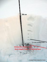
On a NW aspect ATL, we remotely triggered a persistent slab that failed at the ground on 3mm depth hoar. The crown was 2-3 ft deep, up to 1F hard, ~300 ft wide. Triggered from ~800 feet away on low angle, NE facing terrain. SS-ASr-R1-D2-O/G
We also skier triggered one small windslab on a crossloaded NW aspect ATL, less than a foot thick. SS-AS-R1-D1-U.
Multiple small sluffs observed on various aspects from the recent snowfall, all harmless.
Weather: Clear skies increased to scattered clouds. Light to moderate westerly winds with occasional light snow transport. from ridgetops.
Snowpack: On E and SE aspects ATL: One test pit and numerous hand pits showed a ~60-80 cm slab (typically 4F) over .5-1 mm rounding facets, typically 4F- or F+. Two ECT’S showed non propagating results (ECTN H Brk and ECTN M PC). We traveled on several slopes up to 45 degrees with no signs of instability. There is a new meltfreeze , ~1cm thick, forming on the surface of S to SE aspects, with small faceting below.
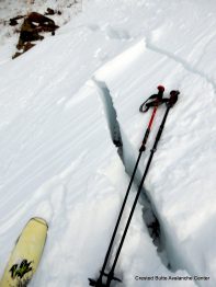
On NW to N aspects N/ATL: We experienced 4 booming collapses, with shooting cracks radiating up to 1,000 feet away. Quite alarming! Structure consisted of 50 cm to 80 cm 4F to 1F slabs over 4F small grained facets over 3mm fist hard depth hoar. It appears that more than half of avalanche terrain had flushed naturally during 11/27-11/28 storm, so the snowpack structure will be quite variable from slope to slope now. Snow surfaces consist of DF grains, windpacked grains, and small facets (less than .5mm)
Some minor, shallow cracking on all aspects ATL isolated to ridgeline windloaded locations.
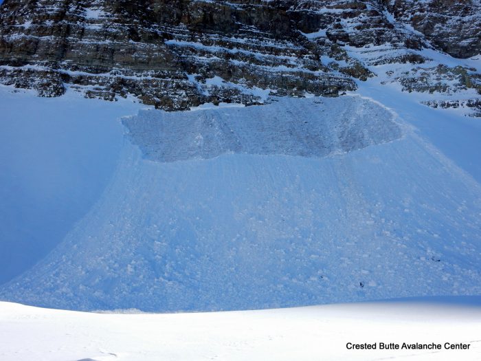
Remote triggered slide today. NW aspect ATL
Remote triggered slide today. NW aspect ATL

Profile dug near the avalanche trigger location.
Profile dug near the avalanche trigger location.

Shooting cracks up to 1000 feet away from trigger location.
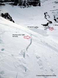
Shooting cracks up to 1000 feet away from trigger location.

NW aspect ATL
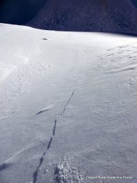
NW aspect ATL

Shooting cracks from trigger location.
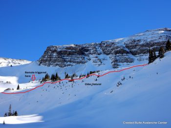
Shooting cracks from trigger location.

NW aspect NTL
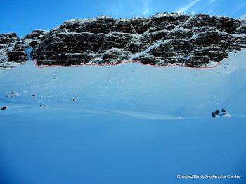
NW aspect NTL

Old crown. N aspect ATL
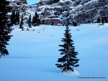
Old crown. N aspect ATL

Old crown. N aspect NTL
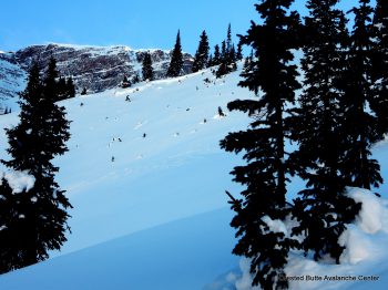
Old crown. N aspect NTL

Old crown. NW aspect NTL
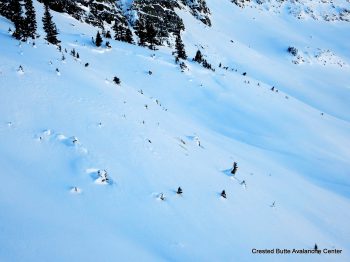
Old crown. NW aspect NTL

Old crown. N aspect NTL
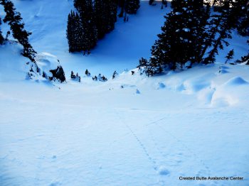
Old crown. N aspect NTL

Old crown. NW aspect NTL
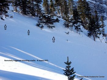
Old crown. NW aspect NTL

NW aspect NTL
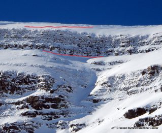
NW aspect NTL

Old crown. ENE aspect Scarp Ridge
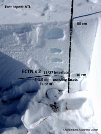
Old crown. ENE aspect Scarp Ridge

E aspect ATL
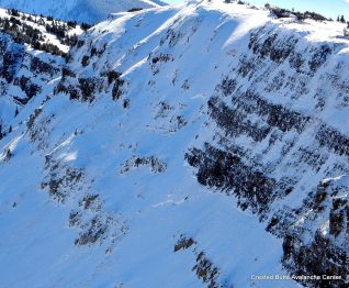
E aspect ATL

Old crown. NE aspect, Scarp Ridge

Old crown. NE aspect, Scarp Ridge