Avy 1 Course: Coneys

CB Avalanche Center2016-17 Observations

Location: Crested Butte Area
Date of Observation: 12/11/2016
Name: Dave B
Subject: Avy 1 Course: Coneys
Aspect: North, North East
Elevation: 9.5- 11K

Avalanches:
Weather: Overcast skies (OVC) nearly all day. Winds Moderate to Intense at times on the ridge, had periods of S 1 snow. Did not amount to much, Morning temp was – 1 c but felt much cooler due to winds.
Snowpack: We got shooting cracks and multiple collapses on our tour up to the ridge. We went up on the west side of coney’s. Skied a lap on the lower angle ridge next to our skin track. Also skied a lap in more of the center of coney’s (2nd Bowl) The skiing was really good. There were only 2 other skiers out there.
Height of snow 83 cm. We had easy results on CTE 4/7 SP tests breaking on a facet layer 40 cm down and a moderate result on an ECTP 16 SP on the same layer. We did not see any signs of instability while we were skiing.

Snowmobiler triggered, caught and buried by PS avalanche

CB Avalanche Center2016-17 Observations, Accidents, Avi-map 16-17

 The complete accident report is now available here.
Location: Paradise Divide Area, Washington Gulch near Elkton.
Date of Observation: 12/12/2016
Name: Evan Ross
Subject: Snowmobiler triggered, caught and buried
Aspect: North
Elevation: 11,250

Avalanches: 2nd hand information. Snowmobiler triggered, was caught and buried by a persistent slab avalanche. They were rescued by the rest of their party, and did not sustain any injuries.

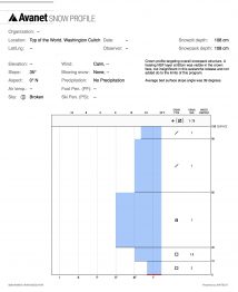
Average slope angle across the bed surface was 39 degrees. Crown was about 175ft wide and 3ft deep. Persistent slab failed at the ground on 2mm faceted grains, 4f- hard.
Weather:
Snowpack:

Crown Profile


Looking across the crown
Looking up at the crown
Burial Location
Looking upslope.  The burial location is in the foreground.

CB Avalanche CenterAvi Blog, Avi-Off-Season

Back in the flow. Zach Guy, CBAC Director

The Western U.S. is coming out of a long drought and the atmospheric snow guns have finally replaced the artificial ones that were building our ski area’s snow base. With snow comes avalanches. There were two avalanche fatalities in the West over the weekend: a skier in closed terrain in Mt Rose Ski Tahoe on Saturday, and a backcountry skier near Cooke City, MT on Sunday. We send our sincere condolences to all of those affected by these tragedies.  Here in Colorado, there has been a stroke of divine luck, with a number of multi-party burials that resulted in profound learning lessons, rather than fatalities. A trio of skiers in Butler Gulch, near Berthoud Pass, were all caught and buried on Saturday. Two of them were only partially buried and were able to rescue the third. On Sunday, a skier was caught in a slide near Red Mountain Pass and two snowmobilers were fully buried but rescued by their group near Steamboat. On Monday, a snowmobiler was buried near Crested Butte.  Needless to say, avalanche season is upon us.


The search area for the avalanche victim at Mt. Rose Ski Tahoe. Photo courtesy of Washoe County Search and Rescue.

The Elk Mountains have been in a favorable zonal flow pattern since December 6th. CBMR reported 18” of snow in the past week, and some of our backcountry areas have picked up almost twice that. More is on the way this weekend. Anytime we have periods of dry weather, especially early season, our snowpack develops weak layers. Once we start getting back into the storm track, those weak layers get loaded and stressed, creating avalanche concerns. Sometimes these avalanches can act in surprising or unique ways, like being triggered from long distances away or from flat terrain. This video demonstrates the challenging nature of persistent slab avalanche problems, where there is a cohesive slab over a persistent weak layer.
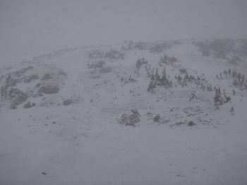

A group of 3 skiers were buried in this slide in Butler Gulch, CO on Saturday. Photo courtesy of CAIC.

It is easy to get caught up in the powder frenzy this time of year. We’ve all been itching to arc those graceful turns down powder filled slopes or throttle through deep pillows and faceshots. But we need to draw a line and stay behind it. One of my mentors up in Montana recently discussed how taking one step back from the line is insufficient. “To ensure a lifetime in the mountains, it is a matter of taking three or four steps back.” The CBAC got an observation yesterday, reporting signs of instability, which concluded with: “Suspect a successful tour could have been had with proper navigation today, but the instabilities spooked us, especially while navigating unfamiliar terrain. We opted to head home.” I applaud that kind of decision making. There isn’t any kind of steep or deep powder run that exceeds the reward of returning home safe at the end of the day.


Snow profile showing unstable results near Crested Butte. 12/11/16

If you are new to the area or visiting, make sure you tune into our avalanche advisories at www.cbavalanchecenter.org. Our forecast team has been in frenzy the last couple weeks to keep tabs on the state of the snowpack. On Sunday, after a big pulse of moisture plowed through the night before, we had all three of our forecast staff up three prominent drainages surrounding our town digging into and documenting the snowpack to help aid in your backcountry decision making. Use our website and observations page as a resource! Give those guys a pat on the back for their often stressful and sleep deprived work during the holiday season. You can just sense the anxiety in Havlick’s voice in this video, and I bet the poor guy hasn’t done his laundry in 2 weeks now. And thank our ski patrollers at CBMR and respect roped off or closed terrain. Those guys and gals are working hard to mitigate avalanche hazards to get terrain open.

Keller Obs

CB Avalanche Center2016-17 Observations

Location: Kebler Pass Area
Date of Observation: 12/11/2016
Name: Steve Banks
Subject: Keller Obs
Aspect: East, South East, South, South West, West
Elevation: 10,500-12,000

Avalanches: A few small 8-15′ wide pockets failed within the new snow, but didn’t gain any momentum on slopes ~35° and only moved less than a foot downhill. With clearing skies in the afternoon, no natural activity was noticed in surrounding peaks.
Weather: Warmer early in the morning with temp dropping to 22° F at 9 am and staying there all day. Winds kicked in at 8 am from the SE with strong to extreme gusts, moving to the W/SW by midday. Ridgtop winds were hitting 60 mph. S5 morning snow tapered through the day with clouds lifting around 3pm.
Snowpack: 7″ new snow overnight with an additional 1″ through the day (most of it blew around/away) Very dense snow with 1.1″ of H2O. Soft slab in the morning stiffened from the wind throughout the day. New snow bonded relatively well to the old surfaces.
Quick compression tests showed mid-storm instabilities with resistant planer shears.

Mountain Weather 12/12/2016

CB Avalanche CenterWeather

Date: 12/12/2016

Elevated winds and cloudy sky will be the theme for the next couple days as Colorado sits under westerly flow. This westerly flow has enough moisture to fuel chances of light snow showers on Monday and Tuesday and keep mostly cloudy sky overhead. Expect continued blowing snow at higher elevations and strong wind gusts. We still have a couple of good chances at snowfall this week, with the next round impacting Colorado starting on Tuesday night and our area a little closer to Wednesday. This looks to be another warm, dense snow producer like last weekend’s storm. Then we’ll close out the week with another large storm arriving Friday evening with what should be colder temperatures and lighter snow.

East ATL

CB Avalanche Center2016-17 Observations

Location: Crested Butte Area
Date of Observation: 12/11/2016
Name: Will Nunez
Subject: East ATL
Aspect: East
Elevation: 10,700

Avalanches: no activity seen
Weather: Increasing clouds- overcasts, moderate winds out of the south with lots of snow transport. Light to moderate snow fall, Temp of 26F
Snowpack: Shooting cracks across E slops when loaded while on skis. A quick snow pit showed an HS 78cm on a 30 degree slope with a surface of 1mm faces F-4F-1F-4F-F. Compression test results; CTM14Q1 at 52cm Dec 6th interface on 1mm facets.

ShootingCrack
CTM14Q1

CBSP control work

CB Avalanche Center2016-17 Observations

Location: Crested Butte Area
Date of Observation: 12/11/2016
Name: CB Ski Patrol
Subject: CBSP control work
Aspect: North, South East
Elevation: 11,800′, 11,600′

Avalanches: Morning Glory: HS-ASr-R3-D3-G
Big Chute: SS-AE-R3-D2-G & SS-AE-R2-D2-G
Powder 8 Gully, Headwall: HS-AE-R3-D2-G
Headwall, Main: HS-AE-R2-D3-G

Touchy to very touchy on specific aspects and elevations. Of specific interest to our local backcountry conditions was the remote skier trigger on Morning Glory.
Weather: 5″ new, .5″ H20. Moderate winds observed, no Wx station data.
Snowpack: 17.5″ Storm total in last 7 days. HS 26″
Profile on 12/10: ECTN15 RP – Failure at 18cm
Results below typically failed on 1-1.5mm facets, stepped to ground.

Purple Palace Instabilities

CB Avalanche Center2016-17 Observations

Location: Paradise Divide Area
Date of Observation: 12/11/2016
Name: Nick Hill
Subject: Purple Palace Instabilities
Aspect: East
Elevation: 9700

Avalanches:
Weather: Snowing intermittently (graupelly), moderate NW winds blowing down valley. Warm.
Snowpack: Lots of whoomping and settling as we began up the steep start to the skin track (100 ft above road). Localized cracking within a few feet of our skis. Most prominent instabilities on a mid pack facet layer (roughly 45cm deep), failed ECT17 Q1 consistently here. The slab above this weak layer did not typically seem cohesive enough to form large slabs, but we suspected isolated pockets may be ready to trigger. This weak layer could become worrysome as the snow above it strengthens.

Also noticed occasional isolated breaks at the storm snow interface where wind loading had formed slabs.

Suspect a successful tour could have been had with proper navigation today, but the instabilities spooked us, especially while navigating unfamiliar terrain. We opted to head home.

North, South East, South

CB Avalanche Center2016-17 Observations

Location: Kebler Pass Area
Date of Observation: 12/11/2016
Name: Evan Ross
Subject:
Aspect: North, South East, South
Elevation: 10,000-11,500

Avalanches: D2’ish debris in the runout of East Bowl. Debris only had a dusting of snow on it, but the crown wasn’t visible in the start zone as it has been filled back in by recent wind loading. Didn’t observe the extent of the debris or crown to estimate any more details.
Weather: Snow showers ended mid-day as overcast sky became mostly cloudy for the afternoon. West/south west winds were generally light with a few stronger gusts. Snow plumes were visibility off most of the peaks during the first half of the day, then fewer in the afternoon.
Snowpack: About 8″ of new snow in the last 24hr. Dens and thicker on top on northerly slopes and softer/more uniform on southern slopes, due to wind effect. A few audible collapses on all aspects but no cracking even on suspect terrain features and on previously untraveled slopes.

North aspect at 10,700. HS 128. 13cm thick layer of facets at the ground were large (2-3mm) and striated, but appeared to have been preciously moist with more of a 4f- hardness to them. The more concerning interface was the 12/6 NSF. This interface was mixed forms .8-1mm NSF and DF. ECTP 26 SP at this interface. No other results while traveling on a number of suspect slopes with this structure. (Some of these slopes likely had previous skier traffic.)

South aspect at 11,100ft, slope 34 degrees, HS 97cm. Most concerning interface was again the 12/6 interface, crust. At the pit location this crust was 4cm thick and produced an ECTP 24 SP result on top of the interface. Where this crust was thinner, around 2cm and softer, observed several concerning collapses below this crust in rounding faceted grains. Didn’t find a theme to these thiner/softer crusts, maybe more southeasterly slopes or lower angled slopes. Never the less, no shooting cracks or results on a number of trigger points and concerning terrain features, but maybe we just didn’t push it far enough looking for a more obvious answer that didn’t need to be found.

W. Brush/Deer Creek

CB Avalanche Center2016-17 Observations

Location: Brush Creek Area
Date of Observation: 12/11/2016
Name: Ian Havlick
Subject: W. Brush/Deer Creek
Aspect: East, South East, South, South West
Elevation: 9000-11400

Avalanches: No avalanches observed aside from one, 12″ deep, remotely triggered, east-facing steep rollover, BTL. Several large, booming collapses, both on uptrack and downtrack, shooting cracks near ridgeline with wind stiffened snow.
Weather: Mostly cloudy, broken skies down valley, moderate to heavy snowfall (S3) until around 1500 when skies rapidly cleared, accompanied by moderate to strong WSW wind, and intense snow transport observed at ridgeline. Temperatures between 28-30º all day.
Snowpack: Long day of breaking trail. New snow accumulation ~12″. Hard to ignore obvious upside-down snowpack structure, with heavy moist snow from this storm resting above colder, lighter density snow/ 1-2mm facets. Average snowpack depth ~70cm. Several large, booming collapses, seemed to propagate a few hundred yards. Cracking in denser, wind-stiffened snow. Moderate WNW winds were efficiently moving snow onto East-facing slopes near and above treeline. One extended column test on E facing slope, BTL, produced ECTP12 SC, 25cm above ground on 1-2mm near surface facets from cold spell.

Slide9
Slide8