Mountain Weather

CB Avalanche CenterWeather

Date: 02/04/2017

A shortwave disturbance is bringing light snowfall to the Elk Mountains today. The best upper level divergence occurs this morning, when we should squeeze out another inch or few under moderate winds. We’ll see a lull on Sunday before the next system takes aim on Monday and Tuesday. This one brings a cold front and better snowfall accumulations.

Mountain Weather 2/3/2017

CB Avalanche CenterWeather

Date: 02/03/2017

Today will be unseasonably warm, with temperatures rocketing into the mid to upper 30s at 11,000ft. West winds will build and shift to the southwest throughout the day with gusts this afternoon into the 40-50mph range as our minor weather maker Friday evening and into Saturday slides closer, and brushes to our north. Saturday will see light snow with accumulations 2-4” and higher amounts possible the farther north you travel. Active weather returns next week, so stay tuned.

Avalanche Accident above Copper Creek

CB Avalanche Center2016-17 Observations, Accidents, Avi-map 16-17

The complete accident report is available at this link.
Location: Crested Butte Area
Date of Observation: 02/02/2017
Name: Zach Guy
Subject: Avalanche Accident above Copper Creek
Aspect: West
Elevation: 12, 200 ft

Avalanches: We would like to sincerely thank the party involved for their prompt and thorough communications with CBAC. This helps turn an accident into a learning opportunity for everyone, helps us improve the accuracy of our forecasts, and we submit accident data to a national database for avalanche-related research.

The slide was unintentionally skier triggered on 2/1/17. We estimate the crown was a 12″-15″ thick hard slab, ~25 feet wide based on photos and descriptions from the reporting party, as well as our on-site observations. The slab likely failed on an old crust or faceted layer. The slab caught and carried the skier approximately 1,350 vertical feet, leaving the skier on top of about 3 feet of debris, a relatively small avalanche. I classified the avalanche as: HS-ASu-R2-D1.5-O.  The injured skier and the skier’s partner evacuated down the rest of the slide path and down part of Copper Creek Trail before CB Search and Rescue arrived and assisted in the evacuation. We will publish a full report summarizing the weather, snowpack, accident, and rescue in the future.
Weather:
Snowpack: No red flags in our tour to and from the avalanche location. No cracking, no collapsing, no recent avalanche activity (except small wet loose on steep southerlies from yesterday), no active wind or snow loading (despite strong to extreme winds today). The parties skin track from yesterday was still largely in tact, suggesting there was minimal snow transport in this area yesterday.
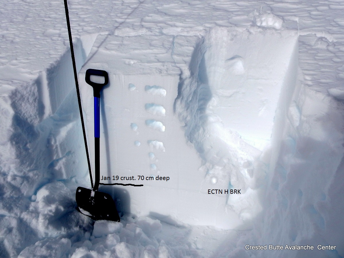
The slide was triggered on a west aspect above treeline at 12,200 feet, above Copper Creek. We traversed across portions of the same slope digging numerous hand pits. The snowpack is generally weak but lacking a slab because it is heavily wind-scoured. The structure consists of either a shallow (less than 50 cm) and fully faceted snowpack, or a faceted snowpack capped by a breakable melt-freeze crust. Behind a few isolated trees and in concavities on this slope, there were shallow hard slabs 3″-5″ thick over this structure. It appears that the slab that was triggered was an isolated drift over this weak structure, which likely failed on crust or facets. The crown was wind scoured or smoothed over by the time we visited the site, so we don’t have any direct crown observations from where the slide was triggered, except for a small pocket lower down on the slope that also pulled out.

Location of the avalanche, on a sub-ridge of White Mountain above Copper Creek.

Looking down the slide path from near the crown.

The crown of a shallow hard slab over weak facets that pulled out lower down the path.

The slide and skier were carried over a cliff band. Skier circled in red for scale.

Skier was recovered on top of about 3 feet of debris, a relatively small avalanche.

Location of skier triggered hard slab avalanche. Photo taken day of accident, 2/1/17


Mountain Weather 2/2/2017

CB Avalanche CenterWeather

 Date: 02/02/2017

Today we will see increased cloud cover and a chance of very light snow across our higher terrain early to mid afternoon. Look for steady, strong west winds to continue near and above treeline and cooling temperatures with this passing shortwave. Friday looks dry but overcast, with another slightly stronger pulse of moisture Saturday. Accumulations with this weekend storm look better, but looking like only 4-6” with this one at the moment.

Independence Basin Avalanche/Obs

CB Avalanche Center2016-17 Observations

Location: Kebler Pass Area
Date of Observation: 02/01/2017
Name: Ian Havlick
Subject: Independence Basin Avalanche/Obs
Aspect: East, South East, South, South West, West
Elevation: 10,000-12,000

Avalanches: HS-N-R2-D2-O. Unknown trigger, possibly natural overnight or remote skier triggered this morning. Ran on slick P+ suncrust and small grained facets above. 150ft wide, running ~500 vertical feet. 34º slope, ESE facing Near/Above treeline.
Weather: Decreasing winds during the day, mild temperatures with high of 36º at 10,000ft. Rapid warm up this morning, but high clouds put a lid on high temps around 1400.
Snowpack: Continued wind loading, hard slabs throughout near and above treelike terrain. Pretty wind hammered. Hard slabs no deeper than 40cm in terrain travelled. HS 280-320cm.

gives and idea of wind texture at ridge top from 3 days of steady west winds
view from just above fracture line.
fracture line blown in, ski tracks visible in upper right corner.

PS becoming less reactive but stiffer

CB Avalanche Center2016-17 Observations

Location: Crested Butte Area
Date of Observation: 02/01/2017
Name: Zach Guy
Subject: PS becoming less reactive but stiffer
Aspect: North, North East, East, South East
Elevation: 9,000 – 10,000 ft

Avalanches: Lots of skier triggered rollerballs on ESE aspects BTL; their first moistening of the week. No new avalanches observed.
Weather: Warm. Increasing thin clouds. Light winds below treeline.
Snowpack: Traveled in two areas near town that held similar snowpack structure to this observation. As we climbed above the inversion, slabs became less faceted, and the recent warming/settling has made the slabs denser and the surface hoar less reactive.  Slightly harder and more propagation in tests (see photos), but we ski cut about 5 steep slopes and couldn’t get anything to move or crack. These same types of slopes were very touchy last week, triggering was almost certain. It seems that instabilities are becoming more isolated, but greater potential for a slide breaking above a skier or a wider avalanche exists now at these locations. The persistent slab structure on SE aspects over the 1/19 interface is changing to a stack of thick crust over faceted snow. No concerns in the morning while the crusts were solidly frozen.  Weak layers on the surface: Small surface hoar and/or near surface facets on most open, shaded aspects. Large surface hoar on a few isolated north facing slopes.

NE aspect 10,000 ft.  32 cm, 4F slab over surface hoar.  ECTP11, SC.  Ski cut this slope where it rolled over to ~38 degrees with no result.
NE aspect 9,300 ft.  CTM, SC, 28 cm deep on SH.  ECTN M on same layer.  F+ slab. Traveled on several slopes up to 35 degrees near this pit and got no signs of instability.
Rollerballs on Southeasterly aspects below treeline.

Mountain Weather 2/1/2017

CB Avalanche CenterWeather

Date: 02/01/2017

We will see impressive morning inversions breaking once again (27º in CB, -2 at GUC) with clear skies and lighter west winds than we saw yesterday at higher elevations. The ridge of high pressure over the western United States begins to erode tomorrow, ushering in high clouds, increased winds, and even a chance of a flurry at higher terrain. More measurable snow does not look to fall until late Friday night, but series of three storms line up for this weekend into early next week.

Improving snowpack

CB Avalanche Center2016-17 Observations

Location: Paradise Divide Area
Date of Observation: 01/31/2017
Name: Zach Guy
Subject: Improving snowpack
Aspect: North East, East, South East, South, South West
Elevation: 9,200-12,500 ft.

Avalanches: -One couch sized cornice fell off of an East aspect ATL today; didn’t trigger anything.
-A D1 wet loose looks like it ran in last couple days on a S BTL slope
-A number of crowns visible from last week’s avalanche cycle. See photos.
-A D2.5 (or larger?) debris pile below East face of Mineral Point, also from last week. Ran full track.
Weather: Strong winds, variable directions but mostly WNW. Light to moderate transport, mostly saltation, not loading. Mild temps. Few clouds to scattered clouds.
Snowpack: No signs of instability. 5 pits from BTL to ATL, generally with strong structure and no concerning results, even on a slope with buried surface hoar.  Ski pen is 10-15 cm BTL and 5 cm ATL. Slab depth down to 1/19 interface ranged from 50 cm BTL to 10-120 cm ATL, depending on wind patterns.  We ski cut and snowmobile cut a number of steep, suspect rollovers with no results on various aspects/elevations. Winds kept surfaces cool where we traveled; no wet loose concerns. Weak layers at the surface have been worked over by the wind. Here are the pit specifics
1. N aspect. 9,600 ft, in wind sheltered area. Could not ID any surface hoar. Q2 CTM and CTH on mid-storm DF’s. ECTN H on mid-storm DFs. Hard to ID 1/19 storm interface, but it was probably about 50 cm deep.
2. ESE aspect. 10,300 ft, in moderately wind affected area. No surface hoar, no PWL or crusts. Q2 CTM and CTH on DFs. Hard to ID 1/19 storm interface, but it was about 50 cm deep.
3. S aspect. 11,500 ft. 70 cm of 4F to 1F slab over Jan 19 crust. No obvious facets around crust. ECTN H BRK above crust.  HS over 400 cm.
4. NE aspect, 11,600 ft. 90 cm of slab over Jan 19 interface. No PWL. CTH Q2 on mid storm DFs
5. NNE aspect 9,600 ft. Adjacent to previous natural avalanche. Jan 19 SH buried 50 cm deep, well integrated into surrounding DFs. ECTN H BRK on SH. CTH Q2 on SH.

D1. SW aspect BTL

NNE aspect BTL. Adjacent to natural slide from last week.  Note the wind-damaged surface hoar on the surface.

South aspect ATL.

D1 wind slab, a few days old.

Surfaces are stiffened and roughened by winds at all elevations.

D2 NE aspect BTL. Profile #5 dug near this slope.

Recent D1 wet loose. S aspect BTL.

D1.5? NE aspect BTL

D2. NE aspect BTL

D2? NE aspect N/BTL

D2 NE aspect NTL

D1.5 NE aspect BTL

D2. East aspect BTL

Impressively far-running debris piles below Climax Chutes. These crowns reported last week.

Mountain Weather

CB Avalanche CenterWeather

Date: 01/31/2017

Mountain temperatures are in the 20’s this morning above sub-zero valley inversions. The ridge of high pressure flattens briefly today as the storm track and jet stream dip closer to Colorado. For us, that will bump up cloud cover and wind speeds, but it won’t deliver any of the white, fluffy stuff. The ridge rebuilds on Wednesday. A small storm is on the horizon for this weekend.

Irwin pits

CB Avalanche Center2016-17 Observations

Location: Kebler Pass Area
Date of Observation: 01/30/2017
Name: Ian Havlick
Subject: Irwin pits
Aspect: South East, South West
Elevation: NTL

Avalanches:
Weather:
Snowpack: See photos