Mountain Weather February 22, 2018

CB Avalanche CenterWeather

Date: 02/22/2018

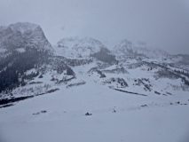
Can you believe it? Snoflakes are still falling. It’s not like it’s nuking snow, nor will it in the near term, but hey at least it’s still snowing.
The big high out in the Pacific is holding that jetstream through the western US, and keeping us in an active weather pattern. The snow showers will keep falling in spurts from now through the weekend. Right now the models show a decrease in snowfall intensity this afternoon and even a partial clearing on Saturday morning. Outside of those two breaks, it’s light snow through Sunday.

  • Today

    High Temperature: 15
    Winds/Direction: 10 to 20, West-Southwest
    Sky Cover: Overcast
    Irwin Snow: 2 to 4″
    Elkton Snow: 2 to 4″
    Friend’s Hut Snow: 1 to 2″

  • Tonight

    Low Temperature: 0
    Winds/Direction: 10 to 20, Southwest
    Sky Cover: Overcast
    Irwin Snow: 3 to 6″
    Elkton Snow: 2 to 4″
    Friend’s Hut Snow: 1 to 3″

  • Tomorrow

    High Temperature: 15
    Winds/Direction: 15 to 25, gusting to 40, South-Southwest
    Sky Cover: Overcast
    Irwin Snow: 2 to 4″
    Elkton Snow: 2 to 4″
    Friend’s Hut Snow: 1 to 2″

East River

CB Avalanche Center2017-18 Observations

Location: Crested Butte Area
Date of Observation: 02/21/2018
Name: Evan Ross

Subject: East River
Aspect: NE
Elevation: 9,000-9,500

Avalanches:

Not seeing anything fresh looking around the East River Valley.

Weather: Clear with increasing clouds in the afternoon. No wind.
Snowpack: 40 to 60cm. Variable snowpack structure, any potential PS avalanche problem was isolated in the terrain. Mostly soft snow over weak snow, or soft snow over wind-board over weak snow. Skiing nicely with yesterdays new snow having come in without wind in the area and cold temps keeping surfaces weakening and soft.

Photos:

West Anthracite Obs

CB Avalanche Center2017-18 Observations

Location: Kebler Pass Area
Date of Observation: 02/20/2018
Name: Andy Sovick

Subject: West Anthracite Obs
Aspect: North West
Elevation: 11000

Avalanches:

Observed many natural slides above TL on leeward slopes.


Weather: Significant winds at high elevations. Plumage easily seen from miles away.

Snowpack: Dug a few pits in the western side of the Anthracites just below TL. 4' to 6' depth. Recent storm layers appeared to be well bonded to each other. Large facets at ground level 5 to 20 cm deep. C.T. and ECT failed at 11th tap at the ground facet layer.

Photos:

Gothic Mountain Tour

CB Avalanche Center2017-18 Observations

Location: Crested Butte Area
Date of Observation: 02/20/2018
Name: Ben Pritchett, Evan Ross, Keith Bauer

Subject: Gothic Mountain Tour

Avalanches:
One small (D1) storm slab on an East aspect at 10,700′ in a forest clearing.
Saw the debris from the Gothic North bowl slide filled the East River creek bed near the 401 / Copper Creek Trailhead.

Weather: Cold. Low visibility. Steady snowfall, light frigid winds. ~4″ new snow near town, ~10″ near Paradise Divide.
Snowpack: Surprisingly not a single collapse observed setting track from Gothic to 403 area down to Pittsburg. Settled, creamy snow surfaces.
Buried crusts down 25cm on Southeast slopes don’t have enough slab to be concerning yet – slab too soft. No propagation in ECT’s, though CT’s pop the facets buried below.
Pushed on several small wind drifts near treeline and these recent pillows and cornices showed only minor cracking near the surface.
If you’re feeding off the audible que’s and avoiding steep terrain, it’s easy to forget there are dangerous deeply buried weak layers in the shady steep terrain.

Photos:

Coney’s

CB Avalanche Center2017-18 Observations

Location: Kebler Pass Area
Date of Observation: 02/20/2018
Name: Chris Martin

Subject: Coney’s
Aspect: North East
Elevation: 9,800 – 10,800′

Avalanches:

none observed but visibility obscured

Weather: Obscured with S1-S2-S1 fluctuating throughout the day.
Light-Moderate NW downvalley winds with minimal drifting down low.
Snowpack: HS 125cm @ 10,800.
HST 8″ low density, no slab yet. Deeper in drifted spots and deeper in valley bottom.
Surface: F-4F-1F-F(became F @ 40cm to ground w/ 2-3mm DH) :Ground

Mountain Weather February 21, 2018

CB Avalanche CenterWeather

Date: 02/21/2018

Enjoy a brief bit of sun this morning, before clouds rebuild this afternoon ahead of our next mini-storm.
An Aleutian High and a wobbling Low in the Great Basin are holding the storm track over Colorado into the near future. We’ll keep the every other day snow pattern going through the weekend.
Tonight, the southwest flow will usher in a few inches valley wide, then tomorrow west-southwest flow will keep the flakes adding up around Kebler and the divide.

  • Today

    High Temperature: 15
    Winds/Direction: 10 to 20, Southwest
    Sky Cover: Increasing clouds
    Irwin Snow: 0 to 1″
    Elkton Snow: 0 to 1″
    Friend’s Hut Snow: 0

  • Tonight

    Low Temperature: 5
    Winds/Direction: 5 to 15, Southwest
    Sky Cover: Overcast
    Irwin Snow: 3 to 5″
    Elkton Snow: 3 to 5″
    Friend’s Hut Snow: 2 to 4″

  • Tomorrow

    High Temperature: 15
    Winds/Direction: 10 to 20, West-Southwest
    Sky Cover: Overcast
    Irwin Snow: 2 to 4″
    Elkton Snow: 3 to 5″
    Friend’s Hut Snow: 1 to 2″

Mountain Weather February 20, 2018

CB Avalanche CenterWeather

Date: 02/20/2018

The big bad wolf tried to blow my house down, but thankfully it’s still standing. A deep trough of low pressure over the western US slung a brief and potent blizzard at us yesterday evening. Snow totals came in below the forecast amounts, but the wind certainly performed.
As the trough axis slides overhead today, we’ll see light snow showers continue over the high peaks under a West Southwest flow, with stinkin cold temperatures, possibly the coldest daytime highs so far this winter.

  • Today

    High Temperature: 5
    Winds/Direction: 10 to 20 West Southwest
    Sky Cover: Overcast
    Irwin Snow: 2 to 4″
    Elkton Snow: 1 to 3″
    Friend’s Hut Snow: 0 to 2″

  • Tonight

    Low Temperature: -10
    Winds/Direction: 5 to 15, Southwest
    Sky Cover: Partly Cloudy
    Irwin Snow: 0
    Elkton Snow: 0
    Friend’s Hut Snow: 0

  • Tomorrow

    High Temperature: 15
    Winds/Direction: 10 to 20, Southwest
    Sky Cover: Partly Cloudy
    Irwin Snow: 0 to 1″
    Elkton Snow: 0 to 1″
    Friend’s Hut Snow: 0 to 1″

Accident on Schuylkill

CB Avalanche Center2017-18 Observations

Location: Crested Butte Area
Date of Observation: 02/19/2018
Name: Ben Pritchett and Evan Ross

Subject: Accident on Schuylkill
Aspect: North East, East
Elevation: 11,300′

Avalanches:

PRELIMINARY DETAILS of an avalanche accident on Schuylkill Ridge in Birthday Bowl area.

2 skiers descended into the skier right side of Birthday Bowl. After a short first pitch, skier 1 was skiing to the right of the Birthday Bowl gully, while skier 2 was posted uphill of skier 1 watching from some distance below the ridge.
Skier 1 heard skier 2 yell, saw snow moving around him, was caught in the slide briefly and pulled under the snow.  After popping back to the surface he was able to exit and arrest by grabbing a tree, moving maybe 100′ downhill. Skier 1 sustained lower leg injuries and lost some gear. After calling 911 to initiate a rescue response learned that skier 2 had already called 911.  Relieved that his partner had called 911 too, skier 1 walked down the skier’s right side of the path to the toe of the debris and found skier 2’s partial burial site and tracks heading downhill.

When the avalanche released, skier 2 yelled to warn skier 1 but was pulled off his feet from his stationary position and carried downhill approximately 1000′ vertical feet in a very rough ride. He sustained substantial injuries along the way from impacts with trees. After coming to rest partially buried on the debris pile, skier 2 initially switched their transceiver to search and did not find a signal. He too contacted 911. Severely injured and without any information about the position of his partner yet, he then began to crawl downhill.

CB SAR rescuers contacted both parties a short distance downhill of the debris, and evacuated both parties for further medical care.

Photos:

Coney’s in the AM

CB Avalanche Center2017-18 Observations

Location: Crested Butte Area
Date of Observation: 02/19/2018
Name: ADB

Subject: Coney’s in the AM
Aspect: North East, East
Elevation: BTL

Avalanches:

NA.

Weather: Sustained moderate winds on the ridge top coming from the west and northwest. Up valley winds on the approach from the trail head to the cabin along above the left bank of the stream. For the most part no snowfall, save for one burst of S1 snowfall with minimal snow accumulation.
Snowpack: Ridgeline: 4 to 6 inch hard slab.
Bowl: 2 to 4 inch soft slabs.
Convex corner has a 1 foot wind lip. One to 2 foot cornices on first and second bowls.
Lower 1/8 of the slope below first bowl and Convex Corner is still a bump run. Upper 7/8 of the slope, winds within past 24 hours have filled in the tracks.

Mountain Weather for 11,000ft February 19th, 2018

CB Avalanche CenterWeather

Date: 02/19/2018

Hold on to small children, because it is windy out there folks! At 11,000ft are in the 25 to 35mph range with gusts in the 60’s. These winds will continue to stay elevated today. The incoming storm is already behind schedule and deflating my powder hungry dreams a bit. There is currently a lot of dry air pushing into Colorado with only a narrow stream of moisture. A low-pressure trough will continue to drop southeast today and develop snow showers. We should still see some decent accumulation during the day with the best snow showers late this afternoon or after dark when a cold front finally drops south. Behind the cold front temperatures will plummet. Tuesday will be very cold with some light snow showers.

The week ahead looks unsettled, with some clouds and cool temps, but not much for snow. A better storm looks to arrive around the end of the work week.

  • Today

    High Temperature: 25
    Winds/Direction: 25 to 35 G50, Southwest
    Sky Cover: Overcast
    Irwin Snow: 6 to 9
    Elkton Snow: 6 to 9
    Friend’s Hut Snow: 4 to 6

  • Tonight

    Low Temperature: 0
    Winds/Direction: 15 to 25, Southwest
    Sky Cover: Overcast
    Irwin Snow: 3 to 6
    Elkton Snow: 3 to 6
    Friend’s Hut Snow: 2 to 4

  • Tomorrow

    High Temperature: 10
    Winds/Direction: 10 to 20, West Southwest
    Sky Cover: Overcast
    Irwin Snow: 2 to 4
    Elkton Snow: 2 to 4
    Friend’s Hut Snow: 0 to 2