Location: Crested Butte Area Date of Observation: 12/08/2018 Name: Irwin Guides
Subject: snodgrass front side obs Aspect: North East Elevation: 10300
Avalanches:
none seen
Weather: mostly clear, occasional overcast Snowpack: Hs 60 cm
6-10 cm of basal facets
1 finger consolidated mid pack with fist hard 10-15 cm surface snow.
lots of collapses in open meadows, shooting cracks. didn’t go anywhere.
CT 11, Ect 11 on NE aspect 10,300 elevation.
-2c air temp
Location: Kebler Pass Area Date of Observation: 12/08/2018 Name: Joey Carpenter
Subject: Slate Obs Aspect: South, South West, West Elevation: 9600-116000
Avalanches:
E face of Richmond 12.2k. SS-N-R1-D2, probably ran yesterday. Observed from very far away.
Numerous point releases on solar aspects in steep terrain.
NE aspect below Schuykill ridge 10k. SS-N-R1-D1, likely from yesterday.
Weather: Varied between FEW and SCT clouds throughout the day with brief periods of S-1 snowfall midday. 5-10mph winds out of the W/NW created light snow transport on W facing aspects ATL, if they weren’t already scoured. Snowpack: 45cm average HS WSW aspect ~10k held melt freeze crust with small facets below from early Nov snow. Thanksgiving storm and snow from last ~10 days is uniform (4F) .
100cm avg HS SW aspect 11k. Three moderate sized collapses in flat, sheltered terrain all within ~20 minutes of each other.
Location: Crested Butte Area Date of Observation: 12/08/2018 Name: ADB
Subject: Coney’s (Late AM/Early PM) Aspect: East Elevation: BTL
Avalanches:
Unlike two weeks ago, no whumping, cracking, or collapsing on and off the skin track.
Weather: Broken skies, calm in the trees with light wind from the west on the open ridge. No snow transport. There was a 5 minute burst of S-1 snowfall in the afternoon with no snow accumulation. Snowpack: Snowpit:
35 Degree slope 50 feet below the ridgeline:
depth: 105 cm of snow.
Did 2 compression tests and both came out CTN.
about 10 cm of facets at the very bottom.
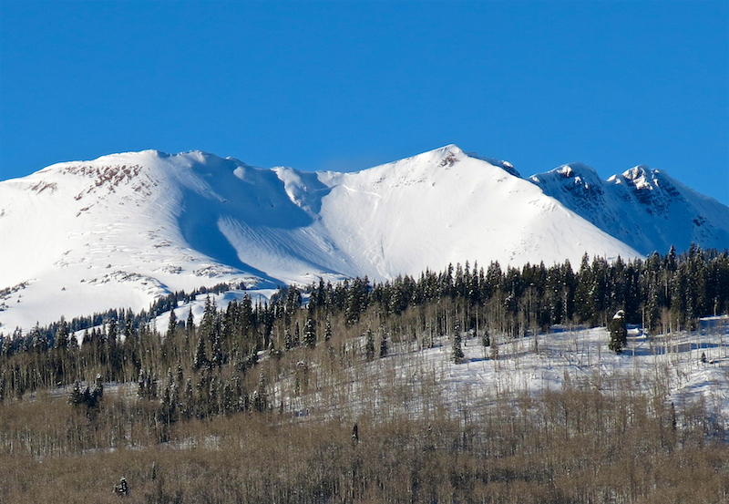
Location: Paradise Divide Area Date of Observation: 12/07/2018 Name: MR
Subject: Pittsburgh Thursday and Friday Aspect: North East Elevation: 9,500-10,500
Avalanches: Weather: Snowpack: Thursday – hoar Frost on skintrack. No signs of instability.
Friday – skiing same terrain as Thursday, got 3 whoomphing collapses
As you stretch those arms this morning, try to flap them around vigorously to help move the low-level clouds out of the area. We’ll not see fog to the same level as yesterday but again will have low-level clouds to start the day off. As these move on their way, we can expect another partly cloudy day. We are starting into west and northwest flow today ahead of an approaching ridge of high pressure. Wind speeds will just be ticking up today in the alpine, then again increasing on Sunday. This ridge will dry us out on Sunday and into the start of next week. With the next round of unsettled weather looking to return midweek.
Today
High Temperature: 28 Winds/Direction: 5 to 15 WNW Sky Cover: Partly Cloudy Irwin Snow: 0-1 Elkton Snow: 0-1 Friend’s Hut Snow: 0-1
Location: Crested Butte Area Date of Observation: 12/07/2018 Name: Evan Ross, Zach Kinler
Subject: Variable Sensitivity Aspect: North East, West Elevation: 9,800-11,000. BTL
Avalanches:
SS-AS-R1-D1.5-O BTL West Facing Aspect. Crown about 60cm with only about 5-10cm of 4f slab in there. Failed on large facets on the ground.
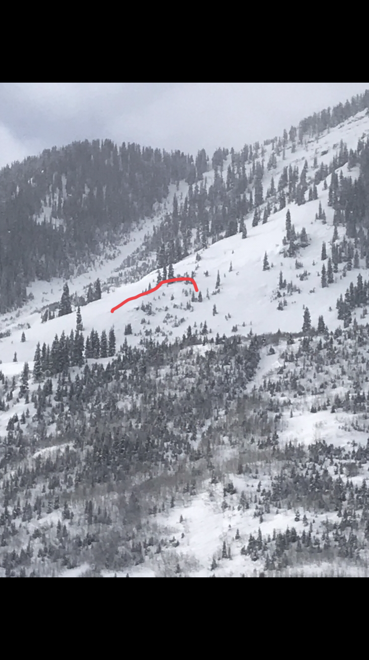
D2.5? Very large avalanche off an Above Treeline easterly aspect of Gothic mountain. Could only see parts of the crown and never saw the debris. Probably ran within the last 24hr.
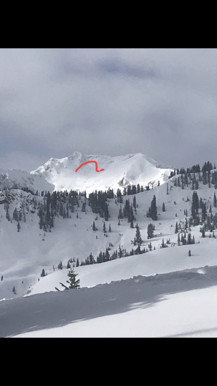
SS-N-R1-D2 ATL on the southerly face of Mt Bellview. Looked like it ran in the upper snowpack as a windslab. Probably ran within the last 24hr.
Belleview Mountain South: SS-N-R2-D2-I (this is a different mountain than the one above.)
SS-N-R1-D2 ATL on an easterly aspect of Baldy Mountain. . Probably ran within the last 24hr.
Numerous small loose snow avalanches that ran today on upper elevation steep and rocky southerly faces.
Weather: Fog in the upper Crusted Butte Valley in the morning and moving out around midday. Otherwise few clouds. Calm winds. Good solar. Snowpack: Variable sensitivity to the PS avalanche problem. On BTL north east, we got some good collapsing and shooting cracks up to 15ft on slopes in the lower 30 degree range. The couple of steeper slopes over 35 degrees we visited had previously avalanche this winter. The slopes that avalanched earlier in the winter had refilled and were tough to distinguish between those that hadn’t avalanched. In a profile on one slope that had previously avalanche, the HS was about 20cm’s less, lacked a slab, but maintained about 5-10cm of large grained facets on the ground. So difficult to tell which slopes or where on a slope the PS structure was present and currently reactive.
On a westerly aspect BTL and protected from the wind, the snowpack structure mirrored that of a NE aspect. Otherwise, the more open westerly aspects appeared thin and sharky.
Photos:
Shooting cracks on NE aspect BTL. 4F mid-pack hanging out over F large grained facets.
NE Aspect BTL. This slope had previously avalanched this year and lacked a slab. The large grained facets where still on the ground.
Looking down a NE aspect BTL that had previously avalanche this year. Difficult to tell
A shooting crack on a NE aspect BTL. The crack shot across the part of the slope that hadn’t avalanche and ended at the part of the slope that had previously avalanched.
D2.5? Very large avalanche off an Above Treeline easterly aspect of Gothic mountain. Could only see parts of the crown and never saw the debris. Probably ran within the last 24hr.
12/8 skier triggered avalanche BTL West Facing Aspect.
SS-N-R1-D2 ATL on an easterly aspect of Baldy Mountain. . Probably ran within the last 24hr.
Location: Crested Butte Area Date of Observation: 12/07/2018 Name: TC
Subject: Red Coon & Red Lady Glades Aspect: South East, South Elevation: 9,200-12,200
Avalanches:
No new slab avalanches, but significant sloughing in RL bowl. Sloughs ran 800+ feet.
Weather: Low-lying fog in the morning (9:30), clearing by 11:00. Zero wind, temp in the 20s. Snowpack: A few fresh inches on top of a melt/freeze crust in Red Coon glades. Still some collapsing ascending Coon Ridge to the summit. No remote triggers, but plenty of fresh loading in the NE terrain of Coon basin. Top 8 or 10 inches was already wet and heavy around 11,000 feet descending back into Red Lady drainage (11:00AM). Wet slides could be an issue on steeper slopes a little later in the day. Observed several fresh slough slides from wind transported snow in Red Lady bowl. Top half of the RL glades skied well while bottom half was wet, heavy & sticky. I imagine things will be crusty tomorrow after tonight’s refreeze.
Location: Crested Butte Area Date of Observation: 12/07/2018 Name: billy barr
Subject: Gothic 7am Report Aspect: Elevation:
Avalanches: Weather: Cloudy, mild and calm with light but steady snow since sunrise Thursday, stopping a bit after midnight this morning. The 24 hour totals, assuming nothing in the next hour, has been 6″ new snow and 0.53″ of water with the snow pack currently at winters deepest of 27½”. Much warmer with the high 29F while staying around 20F overnight (currently 19F). Cloudy now but I did see a few stars pop out abut a half hour ago. Yes, the universe is still out there (of course the light I saw was millions of years old so who can tell). Snowpack:
Wind speeds have really dropped off since midnight allowing for calm conditions Friday morning. Low-level clouds have filled into the valleys creating overcast sky. Those winds will remain light today and those low-level clouds should dissipate a bit throughout the day, but you can still expect upper-level clouds to keep it a mostly cloudy kind of day. The chance for light snow still remains with this moisture in the area. Going into the weekend, this morning’s southwesterly flow will become westerly on Friday and eventually northwesterly by Saturday. We’ll see clouds and moisture slowly decreases during this time, before conditions dry out as a high-pressure ridge moves in for later this weekend and takes us into the start of next week.
Today
High Temperature: 28 Winds/Direction: 0 to 10, WSW Sky Cover: Mostly Cloudy Irwin Snow: 0 to 1 AM Elkton Snow: 0 to 1 AM Friend’s Hut Snow: 0 to 1 AM
Tonight
Low Temperature: 15 Winds/Direction: 5 to 15 WNW Sky Cover: Partly Cloudy Irwin Snow: 0 to 1 Elkton Snow: 0 to 1 Friend’s Hut Snow: 0 to 1
Tomorrow
High Temperature: 28 Winds/Direction: 5 to 15 G25, WNW Sky Cover: Partly Cloudy Irwin Snow: 0 Elkton Snow: 0 Friend’s Hut Snow: 0
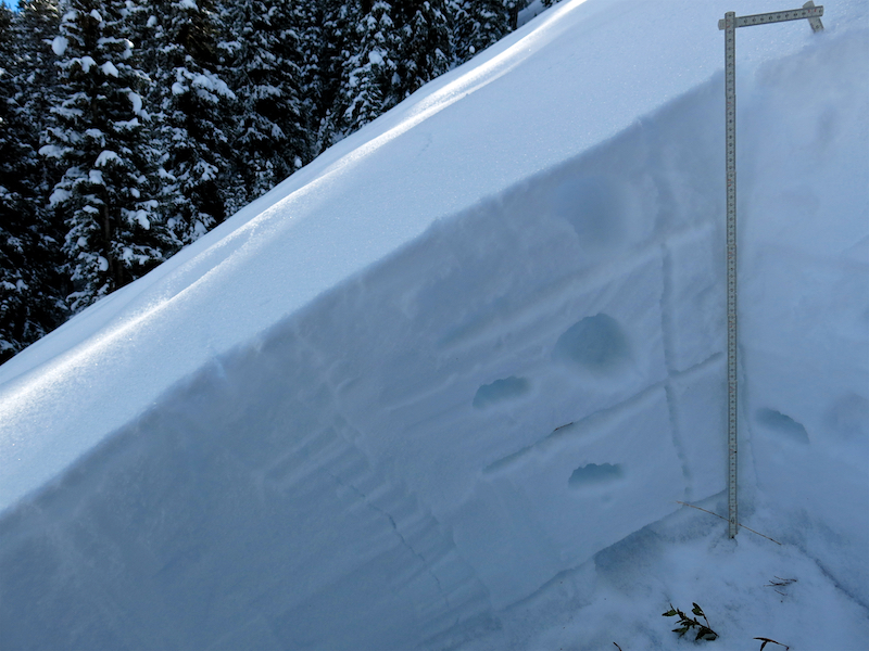
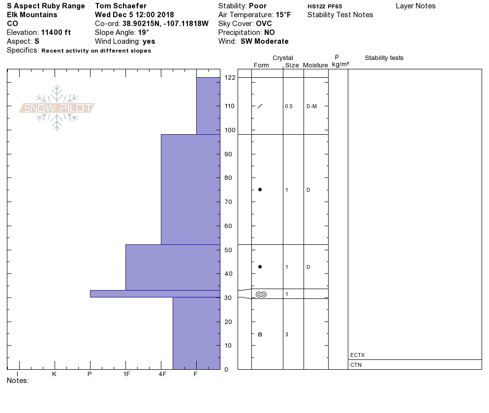
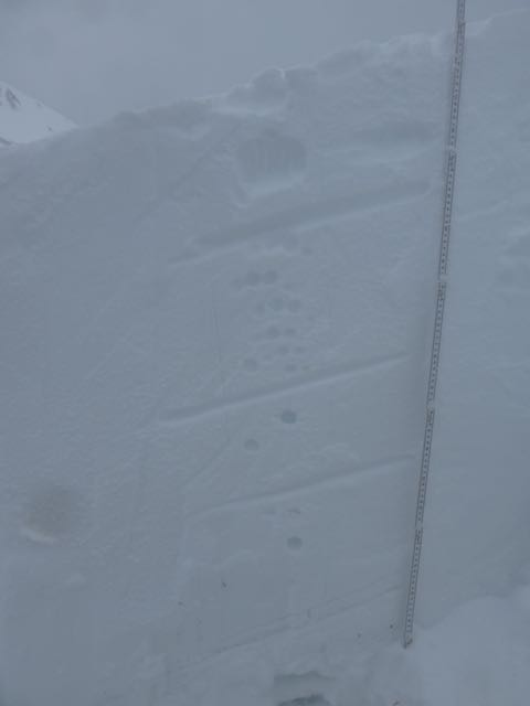
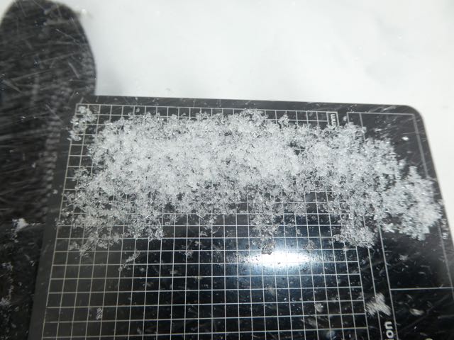
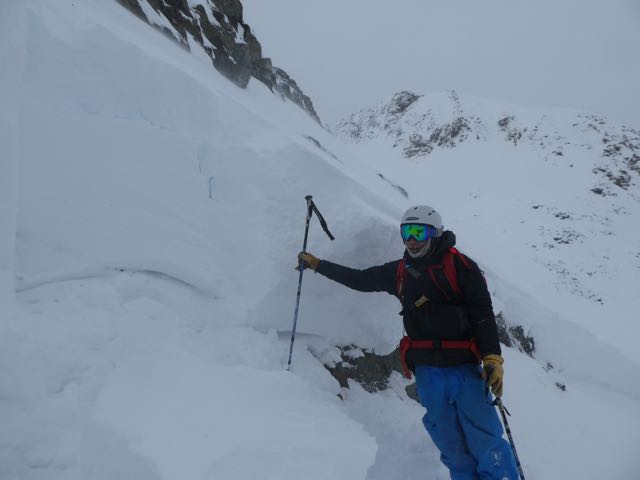
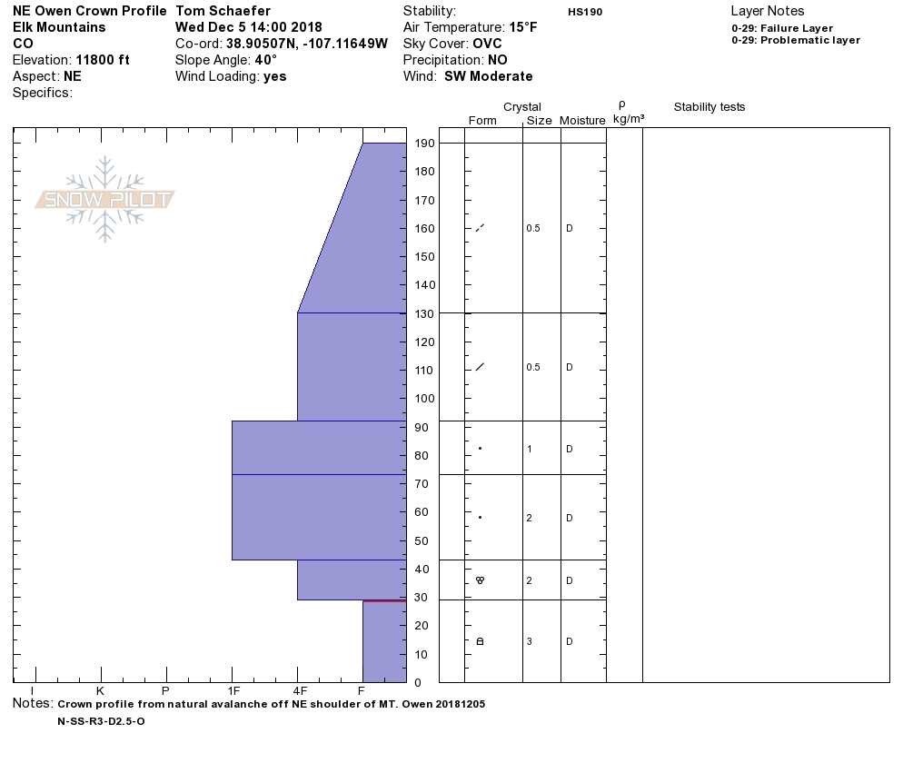
Location: Kebler Pass Area Date of Observation: 12/05/2018 Name: Tom Schaefer
Subject: Mt. Owen Profiles Aspect: North East, South Elevation: 11400′
Avalanches:
12/4/2018
#1 (Green Lake Gully Washer) N-SS-R2-D3-O
#2 (SE lookers right of GLGW) N-SS-R2-D2-O
12/5/2018
#3 (NE shoulder of Owen) N-SS-R2-D2.5-O
Appears all 3 failed on the Nov. 22 interface
Weather: Overcast throughout the day temps in the teens with steady moderate winds from the SW. ATL snow was continuously being transported onto lee slopes. Snowpack: Headed out to Mt. Owen to check out 3 natural avalanches off Mt. Owen that occurred between the 4th and 5th. Ski pen 15cm, boot pen 65cm. Avg. HS on the bench below Owen was 120cm avg. Along Scarp ridge on the windward side was avg. of 30cm. of soft snow . Pack has become more supportive, but in general there is still plenty of snow available for transport.