Observations

02/07/23

Schuylkill sluffs

Date of Observation: 02/07/2023
Name: Josh Jones

Zone: Northwest Mountains
Route Description: Schuylkill Ridge NE

Observed avalanche activity: Yes
Avalanches: Saw and triggered a few small loose sluffs on steep rollovers.
Snowpack: Probed at 10400 on a NE sheltered aspect, 175 CM.

Photos:

5973

Read Full Observation
02/06/23

Skier triggered wind slab on Emmons

Date of Observation: 02/06/2023
Name: Zach Guy

Zone: Southeast Mountains
Route Description: Mount Emmons to 11,800′ on SE, E, and NE aspects.

Observed avalanche activity: Yes
Avalanches: Unintentionally ski triggered a small wind slab, about 10″ thick. I was hunting for wind slabs below a leeward ridgeline with unproductive ski cuts, but further down the slope than expected, a small pocket popped while I was skiing.  Some folks at the trailhead reported triggering shallow soft slabs in Elk Creek area as well.
Weather: Cold, partly cloudy, a few brief flurries, and light to moderate northwest winds lightly drifting snow on ridgelines.
Snowpack: About 3″ to 4″ of new snow had been redistributed by southwest winds near and above treeline, with a bit of drifting shifting to northwest today. HS ranged from 180 to 210 cm near treeline where I probed. Also checked out a wind protected, northeast facing path that avalanched to near the ground in January. There, the snowpack was unusually shallow (HS 60 to 80cm in a few handpits), but the persistent slab structure appeared to be lacking the slab (snowfall after the avy has subsequently faceted), the original basal weak layer, or both. The most recent slab-forming event (late Jan) was unreactive in stability tests and while skiing steep terrain up to 40 degrees.

Photos:

5972

Read Full Observation
02/06/23

Wet Slides on Death Pass

Date of Observation: 02/05/2023
Name: Chris Read

Zone: Southeast Mountains
Route Description: Brush Creek to Friends Hut

Observed avalanche activity: Yes
Avalanches: 2 wet slides on Death Pass. Occurred sometime between 9:45 and 3:30.
Weather: Sunny, warm, windy
Snowpack: Sun effected, wet

5970

Read Full Observation
02/06/23

Gothic Weather report

Date of Observation: 02/06/2023
Name: Billy Barr

Zone: Southeast Mountains
Route Description: Gothic townsite obs

Observed avalanche activity: No
Weather: Snow started near midnight and continued generally light until around 5 a.m. with 3½” new and water of 0.30″. Snowfall was moderate density but wind driven so the measured amount is dense. Currently cloudy, windy and mild with the low 15F after a high yesterday of 43F. billy

5968

Read Full Observation
02/05/23

Ruby Range deep and quiet

Date of Observation: 02/05/2023
Name: Eric Murrow

Zone: Northwest Mountains
Route Description: Slate TH to Poverty Gulch on sled. Tour into upper Poverty Gulch between Augusta and Purple

Observed avalanche activity: Yes
Avalanches: A couple of loose avalanches from steep sunny features from recent days, small size.
Weather: Thin, high cloud cover turned into partly cloudy skies as the cloud deck lowered. Obvious increase in wind speeds in the PM. Blowing snow was frequent at the highest elevations during the afternoon, but actual loading and thin slab formation looked pretty isolated.
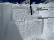
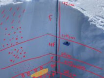
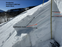
Snowpack: Toured around easterly aspects from 9,800 to 12,200 feet. Snowpack test on drifted alpine slope produced no results. Surfaces near and above treeline remain dry on west through north through east aspects or in the warmest shoulder aspect locations… fragile, soft crusts. The south half of the compass developed crusts 2 – 3 cm thick on steep slopes. The exception to this was sunny terrain with dry fetches nearby…these start zones had two thinner melt/freeze crusts from warming and drifting over recent days (like the test profile in photos). Slope scale sunnies at all elevations no longer seem as concerning for avalanches to break at the old storm interface now that crusts will remain frozen and presumably buried by the incoming storm.
We observed numerous aggressive ski/snowboard lines on north through east through south slopes over the past few days in this area without incident.

Photos:

5967

Read Full Observation
02/04/23

Top of Zachary’s

Date of Observation: 02/04/2023
Name: Daniel Hogan

Zone: Southeast Mountains
Route Description: Traveled up Copper Creek to get to gain the saddle above Zachary’s and continued up towards to check out the other side of the ridge. Skied down a bit to dig a pit just to looker’s left of the Zachary’s entrance with ETCP23 results that failed on the depth hoar layer around 30 cm above the ground surface.

Observed avalanche activity: Yes
Avalanches: Lots of small wet loose slides on south-southwest aspects.
Weather: Cool in the north/western protected valley, clear, between -12 to -5 C over the day.
Snowpack: Snow held up on north facing slopes, but had an inch or so crust in the sunny areas or anything that had a hint of a south facing aspect. Small runnels from melt water were visible on these south facing slopes.

Photos:

5966

Read Full Observation
02/03/23

Recent natural in Evan’s Basin

Date of Observation: 02/03/2023

Zone: Northwest Mountains
Route Description: Evan’s Basin

Observed avalanche activity: Yes
Avalanches: Large natural slab avalanche out of Evan’s Basin. Guessing it ran yesterday (2/2)

Photos:

5965

Read Full Observation
02/03/23

Not happy about southerlies

Date of Observation: 02/03/2023
Name: Zach Guy

Zone: Northwest Mountains
Route Description: Toured on southerly and northerly aspects from Scarp Ridge to Schuylkill Ridge through Peeler and OBJ basins.

Observed avalanche activity: Yes
Avalanches: Several small wet loose avalanches and a pair of soft slabs (~D1.5) on steep, sunbaked slopes that all appeared fresh in the past day or so, best guess is yesterday afternoon, based on the pattern of rollerballs associated with the slides. Also documented a handful of large slabs that ran during the last storm.
Weather: Strong inversion. Warm temps and strong sunshine on sunny slopes, just a few thin clouds. Calm winds.
Snowpack: Today’s goal was to cover ground and test a number of suspect slopes near and above treeline. Unfortunately, we are still getting consistent propagating results on the buried near surface facets and faceted crusts about two feet deep on all south and southeast slopes that we tested near treeline. These typically failed after additional loading steps (30 to 35 taps). I got non-propagating fractures on two pits on northerly aspects; one targeting a heavily drifted terrain feature above treeline adjacent to a large crown from the last storm (the slab was pencil hard). The other was a moderately drifted slope near treeline, 4F slab. I did not experience signs of instability underfoot except some rollerballs and pinwheels on sunny aspects.

Photos:

5964

Read Full Observation
02/02/23

Snodgrass crown investigation

Date of Observation: 02/02/2023
Name: Eric Murrow

Zone: Southeast Mountains
Route Description: Snodgrass front side.

Observed avalanche activity: Yes
Avalanches: A suspected remotely triggered avalanche and an adjacent ‘other’ avalanche. Maybe sympathetic maybe natural??
Weather: Clear skies, mild temperatures, and light winds.
Snowpack: I went to investigate the snowpack structure in an avalanche observation submitted on the morning of 2/2 ( original observation – https://cbavalanchecenter.org/solo-snod-surprise/ ). While driving to the Snodgrass TH, I observed another avalanche adjacent to the one reported. My observation comes from the looker’s right avalanche, not the one with the track next to it. This avalanche failed on a facet/crust layer in the middle of the snowpack; the total depth was around 3 feet with a 16-inch deep crown. I am uncertain of the exact interface date, but it was certainly prior to 1/27 which is the date for the last storm interface. Test results in two nearby places produced ECTN moderate and unstable ECTP 9 results. I think part of the avalanche failed above the crust and part of it failed below the crust. The bed surface was hard to make sense of due to warm temperatures from yesterday and the wet surface snow in the bed surface while I was on site around 2pm on Thursday. While exiting the crown site, I collapsed a portion of the hangfire, but it did not avalanche…likely due to lower slope angles. Sunny slopes in this area were wet in the top 2 inches of snow with another inch of moist snow below that.

Photos:

5962

Read Full Observation
02/02/23

Weekly Snowpack Summary Jan 27 – Feb 2, 2023

The weekly snowpack summary is here. Over 2 feet of snow fell between Friday and Monday. High winds on Monday added to the new load and a natural avalanche cycle ensued. High pressure moved in by the week’s end.

Weekly Summary January 27 – February 2, 2023 COMPRESSED

Read Full Observation
The blog.