Observations

02/16/23

Thicker snow and quiet on the avalanche front

Date of Observation: 02/16/2023
Name: Evan Ross

Zone: Northwest Mountains
Route Description: Mount Axtell north 9,500-11,500. Evan’s Basin E-SE 9,500-11,300.

Observed avalanche activity: Yes
Avalanches: Looking out from Axtell I just noted a few old, small avalanches near ridgelines. Nothing notable stood out.

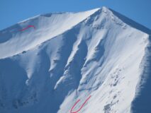
Red Lady Bowl looked to have a small wind slab that may have run today, otherwise, it was from yesterday.

One more small wind slab to add onto ZG’s ob that probably ran today in the Whetstone Group. East, 12,000ft.

Weather: Clear and cold. Snow plumes off the high peaks at times throughout the day, becoming more continuous in the afternoon.

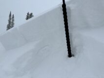
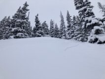
Snowpack: On Mt Axtell, the upper snowpack had become notably stiffer when compared to yesterday, from the cold temperatures and previous wind effects. We skied steep slopes to around 40 degrees and didn’t encounter any storm slab avalanche problems. Sluffing was also minimal. Ski quality had decreased from yesterday, but was still good. Recent wind loading patterns are all over the place and not following a specific trend given all the variations in wind direction we have seen. Wind slab travel advice would have been more appropriate than a widespread storm slab avalanche problem today.

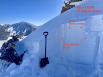
Over in Evan’s Basin, the conditions were similar. I didn’t encounter any unstable snow on this quick trip. Wind slab travel advice would have also been more appropriate in that terrain. I targeted a couple of test profiles on east and northeast-facing slopes to look at the 2/13 interface. On a 38-degree east-facing slope at 10,500ft, the 2/13 interface didn’t produce any results and didn’t look very concerning. On a cross-loaded 35-degree NE-facing slope at 11,000ft the 2/13 interface also didn’t produce any test results. Those small facets at the interface were still something to keep an eye on. The density change in the storm snow did produce test results, but snowmobiling through many steep test slopes didn’t produce any signs of instability.

Photos:

6001

Read Full Observation
02/16/23

Whetstone wind slabs

Date of Observation: 02/16/2023
Name: Zach Guy

Zone: Southeast Mountains
Route Description: Mt. Whetstone, viewed from Mt. CB

Observed avalanche activity: Yes
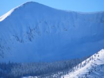
Avalanches: A handful of natural slab avalanches above treeline that ran during the storm, appear to be wind slabs ~D1.5

Photos:

6000

Read Full Observation
02/15/23

Elkton Knob descent of the Gothic Mountain Tour observations

Date of Observation: 02/15/2023
Name: Eric Murrow

Zone: Northwest Mountains
Route Description: Slate TH on snowmo’s to Pittsburg. Tour along the Gothic Mountain Tour descent route off Elkton Knob.

Observed avalanche activity: Yes
Avalanches: Handful of small, natural avalanches failing midstorm depth. Remotely triggered three small avalanches on drifted terrain features at 10,900 feet, avalanches failed at the mid-storm interface.
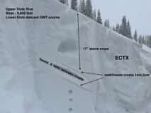
Weather: Light snowfall and light winds in this area. Settled storm total of 17″ at 10,000 feet near Pittsburg and only about 10″ at the Slate River trailhead.
Snowpack: The storm snow was generally stubborn to human triggers in sheltered areas as the strong precipitation rates had ended before we were in the terrain but cracking up to a ski length was common. Drifted slopes remained very sensitive at the mid-storm interface into the afternoon and up to 2 feet thick. Digging into the west-facing slopes at the bottom of the Elkton Knob descent I found a facet/crust weak layer beneath the storm snow that was unreactive in snowpack tests and to human triggers (see photo). The slab above is not big enough in sheltered areas to collapse the underlying crust BUT could be on drifted terrain or in the future with further loading events. The drifted southwest-facing slope, at 10,900 feet, where I was able to remotely trigger small avalanches has a very strong crust, around 6 inches thick, below the storm snow.

Photos:

5998

Read Full Observation
02/15/23

Small storm slabs and sore hip flexors

Date of Observation: 02/15/2023
Name: Evan Ross

Zone: Northwest Mountains
Route Description: AMR. 10,000ft to 11,500ft. N-E.

Observed avalanche activity: Yes
Avalanches: Fairly widespread natural storm slab cycle that likely occurred during the early AM hours. All small or D1 in size.

Weather: Headed out at 8:30 am and snowfall was tapering off over the next few hours. Mostly S1 to S-1 through that period. Mostly light winds with some moderate gusts out of the E-SE.

Snowpack: HST was ~50cm at 10,000ft. There was a notable density change in the storm snow that was responsible for all the avalanche activity that I was able to look closely at. In areas without notable wind-loading that weak layer was down anywhere from 10 to 30cm depending on elevation and how close to the Kebler Pass Trailhead. In the morning the storm slab avalanche problem was reactive, then by mid-day, it was becoming less reactive and trending towards stubborn.

Around 11,000ft there was notable previous drifting from the south side of the ridge to the north side of the ridge. Skinning on the south side of the ridge you were either walking on the old crusty snow surface or through thick wind wales.

Photos:

5997

Read Full Observation
02/15/23

Storm slabs on Mt. Emmons

Date of Observation: 02/15/2023
Name: Zach Guy

Zone: Southeast Mountains
Route Description: Rec tour on Mt. Emmons, traveling on northeasterly aspects below treeline.

Observed avalanche activity: Yes
Avalanches: Skier triggered a few thin storm slabs breaking on a density change mid-storm, D1 in size. Also observed several natural storm slabs that ran overnight, same character and size.
Weather: Light snowfall and light easterly winds both tapered to nil by this afternoon.
Snowpack: Storm total was up to 12″ on the small-grained near surface facet interface. There was a pronounced density increase in the storm snow that happened mid-storm, which was the source of today’s problems. Slabs cracking on this mid-storm weak layer ranged from 3″ to 8″ thick, depending on elevation. Higher elevations approaching treeline were more reactive.

Photos:

5996

Read Full Observation
02/15/23

Gothic weather update

Date of Observation: 02/15/2023
Name: billy barr

Zone: Southeast Mountains
Route Description: Gothic Townsite

Observed avalanche activity: No
Weather: The wind is the dominant factor as it makes things look (and feel) worse than they are. The heaviest snow was in a short period after dark but there was light snowfall yesterday afternoon and snowing most of the night with the 24 hour totals 4½” and water of 0.34″. Wind was stronger after midnight with steady 5-10 SW wind gusting to 20. Nothing massive on the wind but consistently irritating. Currently overcast with moderate SW wind and very light snowfall and the snowpack at 59″. billy

5995

Read Full Observation
02/14/23

Powentine’s Day

Date of Observation: 02/14/2023
Name: Zach Guy

Zone: Northwest Mountains
Route Description: Afternoon tour in the Anthracites, poked around on a variety of aspects to 11,500′

Observed avalanche activity: Yes
Avalanches: Skier triggered a couple of thin soft slabs near wind drifted ridgelines, ~6″ thick, small in size. Also some shallow sluffing on very steep, below treeline terrain.
Weather: Moderate snowfall rates. Light winds where we traveled with evidence of stronger winds in other locations. Overcast skies.
Snowpack: Storm total was 6″ at Ohio Pass and up to 10″ at the top of AMR, low density, cohesionless snow. There was just enough wind drifting to add cohesion and form isolated soft slabs near ridgetop, still fist hard, but propagating 20 feet. I also produced localized cracking 2 to 4 feet under skis in drifted areas. Otherwise, the new snow sluffed underfoot on slopes steeper than about 38 or 40 degrees.

Photos:

5993

Read Full Observation
02/14/23

Touchy new interface

Date of Observation: 02/14/2023
Name: John M

Zone: Northwest Mountains
Route Description: Axtell 1st bowl

Observed avalanche activity: Yes
Avalanches: Touchy interface with new snow
Weather: Overcast with light snow becoming heavier in early pm
Snowpack: Sloughing new snow from interface in new / old snow. Otherwise quiet

Photos:

5992

Read Full Observation
02/13/23

Surface obs before the storm

Date of Observation: 02/13/2023
Name: Zach Guy

Zone: Northwest Mountains
Route Description: East Beckwith, traveled on SE to NE aspects to 11,600′

Observed avalanche activity: Yes
Avalanches: Skier triggered a small sluff that gouged into old snow on a very steep, rocky face with a shallow snowpack.
Weather: Clouds increased late morning from clear to overcast. Light snowfall began around 1 p.m. along with periods of snow transport from moderate south winds.
Snowpack: The snow surface is faceted on colder aspects: anything north of ESE. Like our January layer, the weak layer on our snow surface isn’t large and well-developed, but could cause storm instabilities to be more sensitive or persist a little while longer than normal. On due east and east-southeast aspects, there is a thin crust (.5 to 3 cm) above small-grained facets (.5-1 mm), with dry, small-grained facets above the crust (.5 mm). On anything north of due east, the crust is lacking, just small-grained facets (.5-.75mm). On southeast and south, the crust is thicker and I didn’t observe any facets above it. As we gained elevation, surfaces are more variable from wind effects and facets are less widespread, with more fragmented and rounded grains from previous wind damage. Snow surfaces are weakest near steep and rocky terrain where the snowpack is shallower.

Photos:

5991

Read Full Observation
02/12/23

Purple Ridge

Date of Observation: 02/12/2023
Name: Eric Murrow

Zone: Northwest Mountains
Route Description: Slate River TH to Purple Ridge skinner up to 11, 700 feet.

Observed avalanche activity: No
Avalanches: none observed.
Weather: Low-level clouds in the morning gave way to high, thin clouds in the afternoon. Mild air temps and light winds.
Snowpack: A skiff of new snow overnight along the Ruby Spine – 1cm or less than a 1/2 inch. I toured around looking at the current snow surface in preparation for the incoming snowy weather. Slopes on the north half of the compass in sheltered areas have very light faceting near the surface but are small in size and do not appear to be all that problematic for the incoming snow. The south half of the compass developed crusts. The surface on a steep south slope at 11,200 feet had around 4 inches of wet snow resting above an old melt/freeze crust. Crusts slowly thin as you transition to due east. Some near treeline slopes facing east had a dusting of new snow that remained dry resting above a thin, melt/freeze crust or windboard. Most sunny features I encountered warmed enough today to glue the dusting of new snow to the underlying crust.
I was able to stomp on a few older, wind drifts near and below treeline without any signs of instability or cracking.

Photos:

5990

Read Full Observation
The blog.