Date of Observation: 12/15/2016
Name: Arden Feldman
Aspect: North East
Elevation: 9100
Avalanches: None
Weather: Overcast, S-1 increasing to S1 by nightfall, Calm winds increasing to Light, minimal snow transport.
Snowpack: See Profile
Avalanches: None
Weather: Overcast, S-1 increasing to S1 by nightfall, Calm winds increasing to Light, minimal snow transport.
Snowpack: See Profile
Avalanches: Old crown – likely from mid-week storm on bowl just to lookers right of Green Lake on Mt. Axtell – R2.5, D2
Weather: Cloudy with periods of clear sky. Light winds from both SW and NW with blowing snow at ridge lines.
Snowpack: See Avanet pit profile attached. HST varied fro 5 cm to 20 cm throughout tour depending on elevation and exposure to wind transport with MFCR sandwich in the top portion of the snowpack. HST was unconsolidated and temps seemed to stay cool today to prevent moisture buildup on SE aspect – maybe down to ~10K’. Descended at ~330 pm.
Did see a repeated CTH results just below the DH layer below an ice layer but think this was due to isolating the column in the test. During my tour and I never punched blow the early March MFCR that sits below the recent storm layers.
Avalanches: None in this area. Observed a handful of fresh wet loose today further up valley in areas that had more snow from the last storm (Mineral Pt, Mt. CB, White Mtn, etc) on SE, S, SW, and W aspects N/ATL, all D1 to D1.5 in size.
Weather: Warm temps. Measured 34*F at 12,100 ft at 14:30. Calm to light breeze from the west. A few thin clouds.
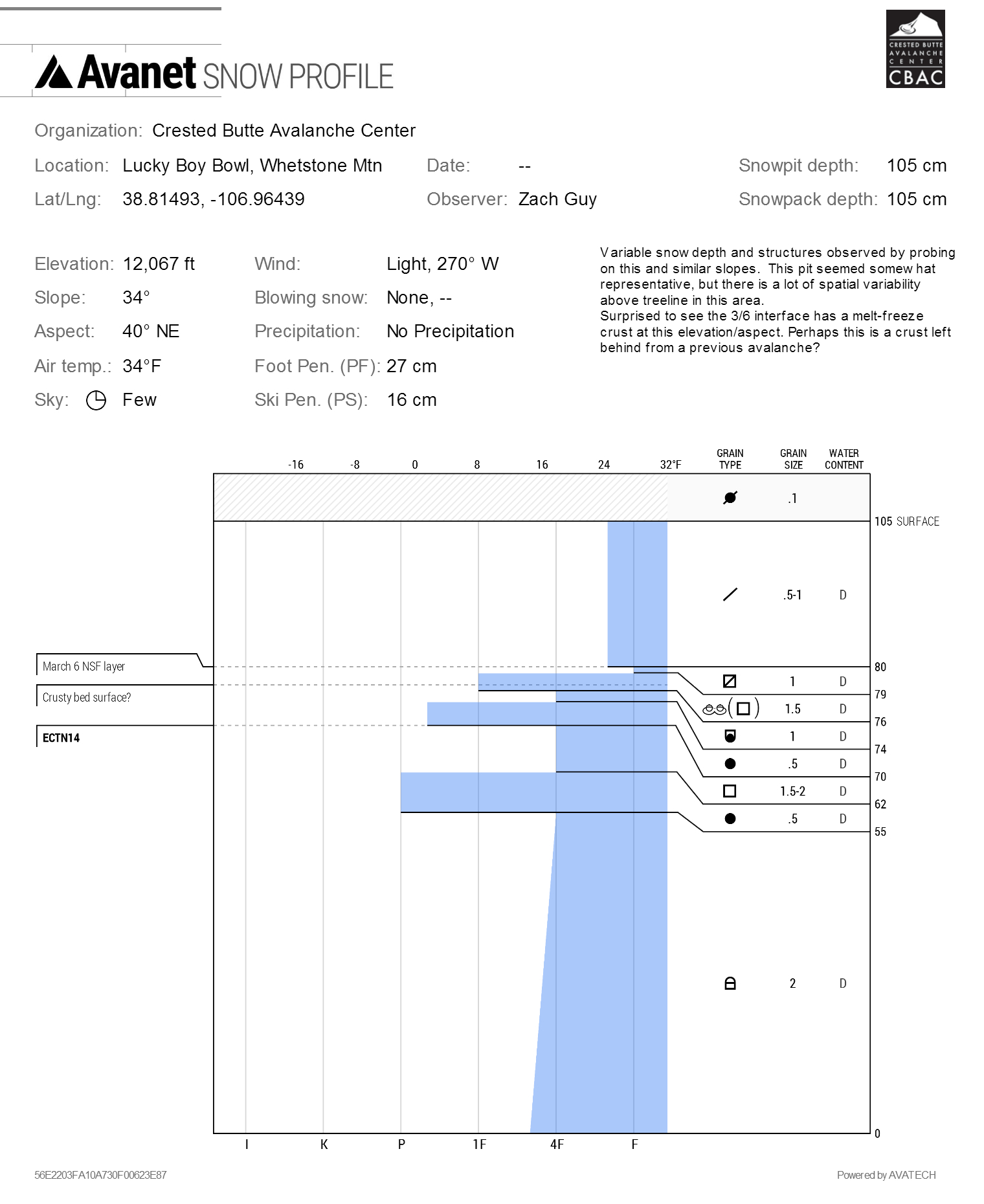
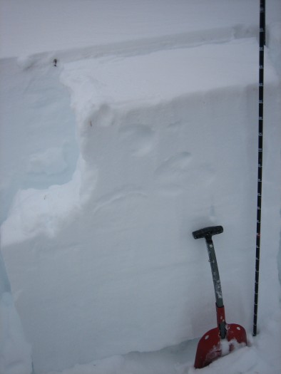
Snowpack: See video. 2-4″ of settled storm snow was not enough to cause any real concerns for wet loose or our new layer of persistent slabs over the 3/6 facets in this area. On SE and S facing slopes, the recent storm snow became wet and consolidated to less than an inch thick above the still frozen 3/6 crust/dust layer without any rollerballs. On the most windloaded ATL slopes facing NE, there was 8″ of F+ settled snow over the 3/6 facet layer, and we did not see signs of instability or get any results on this layer in a pit. I probed around on several E and NE facing slopes above treeline and found a widely variable structure, generally shallow. Profile from a somewhat representative location below.

3/10. Snow profile on NE aspect ATL of Whetstone Mtn
Natural wet loose off of S face of Mineral Point
Avalanches: No new avalanches observed. Old crowns from early Feb storm can still be seen.
Weather: @ ~11:00 am, overcast, calm winds, light snow (S1 – S2)
Snowpack: See attached test profile from NE aspect on Snodgrass. HS of 160 cm with a fairly well-developed layer of near surface facets in the top ~5 – 10 cms that sat above a cohesive slab of various firmness down to 45cm. Large F firmness DH from here to ground. Managed a CTH result on the slab / DH interface @ 45cm.
Highly variable snowpack on the way down on similar aspect ranging from the snowpack described above, to fully-faceted, to sun crusts, to bed surfaces from early Feb avy cycle. Facet sloughs were easy to initiate on steeper slopes but ran fairly slow. Near surface facets layer would seem to be one to keep an eye on during the next storm.
Avalanches: No recent avalanches or signs of instability en route to Friends Hut. It looked like only 2 of the big SE/E facing paths above Brush Creek on Timbered Hill ran naturally during 2/1 cycle, D2 in size. Never got good views of the alpine above Friends Hut.
Weather: 2/21. Warm, few clouds.
2/22. Overcast skies cleared to scattered. S-1 to S1 in the a.m., with less than an inch of accumulation. Moderate NW winds with moderate transport at times.
Snowpack: (See video). HS at Friends Hut is ~150cm. On the approach on Sunday afternoon, steep southerly BTL slopes were completely saturated and unsupportive (or melted out to dirt), but appear to have matured beyond wet loose or wet slab concerns. Overhanging slopes above Death Pass had minimal and patchy snow coverage. Dust event reached out to Upper East Brush as well, but not as bad as near town. Snow profile on a low angle, sheltered, northwest aspect near treeline showed a stubborn PS structure, with propagating test results after additional loading steps beyond standard ECT. See profile. I would expect starting zones on similar aspects to hold a widely varying structure due to our previous avalanche cycles and/or wind events.

Snow profile. NW aspect NTL near Friends Hut
Avalanches:
Weather:
Snowpack: See profile