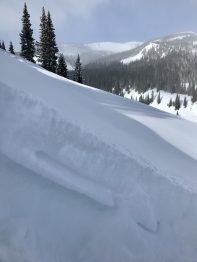
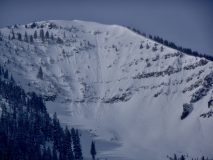
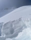
Gothic Townsite Obs 0600

CB Avalanche Center2019-20 Observations

Location: Crested Butte Area
Date of Observation: 02/08/2020
Name: billy barr

Subject: Gothic Townsite Obs 0600

Weather: Snowfall was off and on Friday and once again wind driven so very dense, then none overnight so 24 hour total (unless it snows in the next hour) is 3" new and 0.35" of water. Cloudy and warm overnight as wind continued though for an hour or two it let up. Then started back but not as strong as the past few days and seems to be residing now. Snow has been drifted everywhere. Current the sky looks cloudy with the overnight high temp 27F, low 24 and current 26F. Snowpack at 36" and wind is light to moderate with occasional gusting. No measurable snow since late day yesterday. billy

Irwin Cat Tenure

CB Avalanche Center2019-20 Observations

Location: Kebler Pass Area
Date of Observation: 02/07/2020
Name: Snow Safety Teams

Subject: Irwin Cat Tenure

Weather: Hola,

An initial decision to delay guest departure while assessing conditions evolved into a cancellation decision before we were half way up Kebler to Irwin. Significant avalanche hazard and road conditions impassable for the Tucker got us part way there. Combining that with a forecast of increasing hazard through the day made the decision obvious.

Snow safety teams continued up and ran control routes to prep terrain. Travel on skis was extremely difficult due to a profound density inversion in the new snow. Normal egress routes that should take 2-3 minutes were 20-30 minute slogs. Ski cutting was almost impossible due to the inability to maintain forward progress. Rescue would have been very time consuming and difficult. Guests would not have had fun with us today.

Our unsettled storm total at noon was 34" with 2.4" of water. It was snowing S2 when we left at 13:00. Fresh slab was notably stubborn to explosive testing, but accompanied by widespread collapsing. Spooky.

Time to make soup. We'll try again tomorrow. cheers…dk

Snowpack:

0600 Snow Report Gothic

CB Avalanche Center2019-20 Observations

Location: Crested Butte Area
Date of Observation: 02/07/2020
Name: billy barr
Subject: 0600 Snow Report Gothic
Aspect:
Elevation: 9400
Avalanches:

Weather: A LOT of noise but not much substance here. Very strong, steady wind all night while staying mild but only 2½” new snow and water 0.22. Because of the wind, swirling even through usually protected areas, it was difficult to get a precise reading on snowfall but this was the best I could come up with using 2 measuring boards. Was mild to warm overnight with the high 22F and low 21F. Currently obscured with strong, steady W wind about 15-20 mph gusting maybe to 30. Snowpack is at 34½” going nowhere with light to no snow right now as it all seems to be wind blown. billy

Storm check

CB Avalanche Center2019-20 Observations

Location: Crested Butte Area
Date of Observation: 02/07/2020
Name: Zach Kinler

Aspect: North, North East, East

Elevation: 9,000′-9,400′

Avalanches:

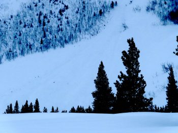
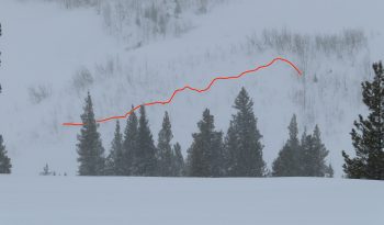
Very low visibility but did see two D1.5 storm slabs on the lower portions of Climax as well as debris in the runout of one of the larger paths.


Weather: Overcast and warmish. Temps around 30F. S1-S2 snow showers. Light- Moderate NW wind.

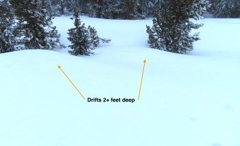
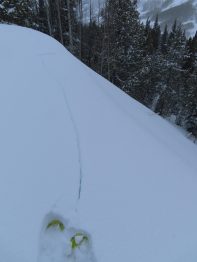
Snowpack: ~30 cm (12″) HST. Persistent NW winds throughout this storm have drifted snow a couple of feet deep on leeward slopes below treeline. Small test slopes greater than 35 degrees N-E were touchy with shooting cracks easily initiated on the flats above. These slopes failed on the 2/3 interface which was buried ~38 cm (15″) in this location.


Below treeline northerly slope with significant drifting.

East aspect with light loading

Small limbs and debris in the runout of Climax Chutes.

Storm slab on a NE below treeline slope


frontside Snodgrass observation tour

CB Avalanche Center2019-20 Observations

Location: Crested Butte Area
Date of Observation: 02/07/2020
Name: AIARE 2 – Irwin Guides
Subject: frontside Snodgrass observation tour
Aspect: East, South East
Elevation: BTL
Avalanches:

Weather: Moderate SW winds at Snodgrass TH, winds light to moderate once you gained the trees. S1-2 most of the day.

Snowpack: Isolated cracking localized to area around skis. SE aspect HS 140cm, 45cm fist-hard PP over 5cm MF crust, P+. Multiple layers of 4F FC with small crusts (P-, .5-1cm thick) that seem to be faceting away. Large column tests produced no propagation, ECTN above the crust, ECTN down 85 cm on an interface between two 4F FC layers. In general, the new snow was unconsolidated and only moving on slopes steeper than 35 degrees, sliding on the MF crust, with no propagation or slab.

Irwin Tenure Obs

CB Avalanche Center2019-20 Observations

Location: Kebler Pass Area
Date of Observation: 02/06/2020
Name: Ian Havlick
Subject: Irwin Tenure Obs
Aspect: East, South East, South, South West, West
Elevation: 10-12,000
Avalanches: (2) SS-AS-R2-D1.5-I 2ft windslabs failing above 2/4 MFcr. 1F dense slab, east facing terrain NTL. Failed pretty early in storm, around 10am. Otherwise, lots of storm slabs all day, growing in size and tenderness late in day. Steep features were sluffing and cracking and running naturally around 1600.

Weather: 2″ 10% density snowfall as of 0800, snow intensified 0930, and stayed pinned at nuking rest of day, west winds were sporadic, also variable at ridgetop (12K).

Snowpack: dense snow transitioned to uber fluff, 7″ .2 SWE by 1600, though it felt and skied much deeper. Small scale local winds patterns were unusually eddying around blowing east, reverse loading interesting places. Wind drifts were unusually fluffy and low density, easily able to ski through waist deep drifts. Snow seemed to be growing in density at sunset

Photos:

Blower, Cotton Fluff, Total Goose Down Bro

CB Avalanche Center2019-20 Observations

Location: Kebler Pass Area
Date of Observation: 02/06/2020
Name: Evan Ross & Eric Murrow
Subject: Blower, Cotton Fluff, Total Goose Down Bro
Aspect: North, South East, South
Elevation: 10,000-11,500ft

Avalanches: Skier triggered a few very small Wind Slabs with crowns up to 35cm. Also a couple very small Storm Slabs in the late afternoon failing within the recent snow.

Weather: Moderate northwesterly winds and blowing snow in all exposed terrain. Snowing S1 to S2 all day. HST was 11″ at 3pm with .48SWE

Snowpack: Impressive very light new snow, definitely representing the definition of blower. Interestingly, even many of the wind-loaded terrain features, where the feathers had been tossed about on there journey to that resting place, were just as low density. So more of a sluffing avalanche problem was encountered and more often than expected. We did find some very soft slabs on other wind-loaded terrain features were we were able to pop a few very small Wind Slabs. These were running both in the new snow, and some down to the 2/4 interface. This will all change with the continued wind and forecasted snow.

Conditions were still blower in the afternoon, but the top 6-8″ of feathery precipitation particles were just starting to crack and buckle as small Storm Slabs releasing on smaller precipitation particles below. One of these Storm Slabs initiated off a skier triggered sluff and propagated surprisingly far on a south-facing slope. Conditions sure will get interesting tomorrow.

Elk Creek Checkin

CB Avalanche Center2019-20 Observations

Location: Kebler Pass Area
Date of Observation: 02/05/2020
Name: Evan Ross
Subject: Elk Creek Checkin
Aspect: North East, East
Elevation: 9,500-10,400

Weather: Down Valley Winds were just strong enough to continue drifting snow through the low elevation corridor. While sky remained in the partly cloudy realm and temperatures were cold.

Snowpack: Cruised across some low elevation start zones facing northeasterly and easterly. Previous wind loading at these lower elevations felt concerning enough to consider today and was apparent with the train management of the previous tracks in the area. Though an avalanche failing in recent snow or in old snow layers both appeared stubborn. Those previously wind-loaded start zones held the strongest looking snowpack. A Wind Slab on wind-board on more wind-board with some weak layers sandwiched in-between. It appeared that a large loading event would fail in the upper snowpack layering or within the new snow, then step down below the wind-loaded terrain into the weaker snowpack below. It didn’t really matter, there is a weak snowpack structure and new avalanches will fail or step down into it with either a rapid or significant load. The most significant weak layer found in this terrain was on an easterly facing slope. Here a thin crust at the old snow surface was sitting above much weaker snow below. Hand pits easily produced results below this crust with the more recent snow riding along. On southerly facing slopes the most recent crust was supportive to both skis and snowmobile, and the next loading event would likely fail above this crust.

Thin crust capping weaker snow below. East aspect in Elk Creek.

Poverty Gulch

CB Avalanche Center2019-20 Observations

Location: Paradise Divide Area
Date of Observation: 02/04/2020
Name: Evan Ross & Eric Murrow
Subject: Poverty Gulch
Aspect: North East, East, South East, South
Elevation: 9,500-12,000

Weather: Partly Cloudy for the AM hours, and increasing to mostly cloudy in the PM hours. Periods of S-. Calm winds became a consistent moderate from the west northwest. New snow was not visibly blowing off the high peaks, but constantly saltating and drifting near the snow surface. Eric climbed in his goggles because his cheeks were apparently cold.

Snowpack: The new snow accumulation was 8″ at 9,600ft in Poverty Gultch. Traveling higher in the terrain, of course, those measurements became more variable with drifting. Drifts 1 to 2ft thick were encountered on wind-loaded terrain. Surprisingly very little instability was found in that new snow or at the old snow surface. Still, managing wind-loaded terrain for new Wind Slabs was the most common problem. We did kick off a couple very small Wind Slabs and chose to travel around some wind-loaded terrain features. The new snow was further becoming thicker throughout the day with the continued wind.

The Persistent Slab problem was considered on one slope that had an ugly terrain trap, and more regularly on very steep slopes that looked to have variable snow coverage through rocky terrain. The new snow had made no change or increased concern for the Persistent Slab Issue. We need a good loading event to collapse recently formed crusts and wind-board or to stress more deeply buried weak layers.

Cement Creek Snow

CB Avalanche Center2019-20 Observations

Location: Cement Creek Area
Date of Observation: 02/04/2020
Name: Cosmo
Subject: Cement Creek Snow
Elevation: 9400

Weather: ~3.5″ new snow since yesterday afternoon (as of 6am 2/4)