Halloween Bowl Paradise Basin

CB Avalanche Center2017-18 Observations, 2018-19 Observations

Location: Paradise Divide Area
Date of Observation: 11/17/2018
Name: Andrew Pearson

Subject: Halloween Bowl Paradise Basin
Aspect: North, North West
Elevation: 11800

Avalanches:

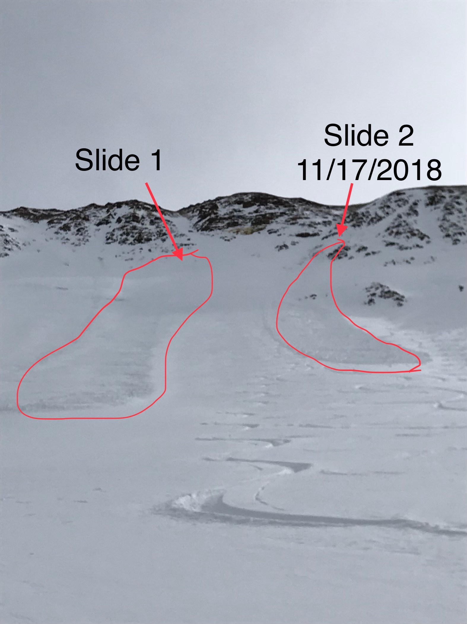
There has been two avalanches in Halloween Bowl out Paradise divide this year. The one witnessed happened 11/17/2018. It was human triggered and broke off in an area filled with trigger points. It didn’t propagate far and did not go all the way to the basin floor. I would call it and R2 D1 slide. The slope angle at and around the crown was 35+ and strictly N aspect. I would imagine that it failed on the faceted weak layer based on the pit I dug, which was right next to the slide same aspect and slope angle.

Weather: Clear, Partly Cloudy. Temperatures stayed around and below freezing majority of the day. Winds in the bowl were light. No precipitation (valid through 3pm).
Snowpack: Snow depth varying depending on wind deposit, but consistently around 70-80 cm in the deeper areas, where the avalanche occurred. In the pit I dug at 55cm was a prominent weak layer with faceted snow. On top sat a more consolidated slab about 20-30 cm deep. Top slab was about four fingers whereas the next layer was fist and rotten. When doing a CT test, There was failure at 55cm at 15 making it a CTM.

Photos:

Natural on NE Aspect, Treasury

CB Avalanche Center2017-18 Observations, 2018-19 Observations

Location: Paradise Divide Area
Date of Observation: 11/11/2018
Name: Joey Carpenter

Subject: Natural on NE Aspect, Treasury
Aspect: North East
Elevation: 12000

Avalanches:

There was a natural avalanche on the NE aspect off the ridge running SE below the “football field” of Treasury. R2D2. Limited visibility did not allow us to get a photo but I approximated on attached map.

Weather: Temps remained in the teens throughout the day. Light to moderate winds were transporting snow along ridge tops. Skies were obscured most of the day with only intermittent periods of longer distance visibility.
Snowpack: Leeward areas contain pockets of stiffening slabs across N, NE & E facing terrain NTL & ATL. 1-1.5mm facets below the crust formed in early November. Facets beginning to form on top of crust as well, .5-1mm in size. Multiple hand shears produced inconsistent slab structure based on location. Areas that have received more wind loading show more cohesive slabs where less wind affected areas have minimal slab cohesion. Spx BTL is more uniform and rapidly weakening.

Photos:

Shallow windalab off SE ridge of baldy

CB Avalanche Center2017-18 Observations, 2018-19 Observations

Location: Paradise Divide Area
Date of Observation: 11/09/2018
Name: Lawson

Subject: Shallow windalab off SE ridge of baldy
Aspect: North, North East
Elevation: 12000

Avalanches:

Shallow windalab naturally released off ene facing ridge into rock Creek basin. Happened 11/9 early or 11/8

Weather: Clear, windy
Snowpack:

Photos:

Snow/Wx Obs

CB Avalanche Center2017-18 Observations, 2018-19 Observations

Location: Paradise Divide Area
Date of Observation: 11/06/2018
Name: Alex R

Subject: Snow/Wx Obs
Aspect: North, North East, East, North West
Elevation: 12,000′

Avalanches:

An avalanche that occurred on Sunday afternoon was still visible today. Located in “College Bowl” on Mt. Baldy, this small slab avalanche started in a rocky outcrop high in the bowl, and stepped down to the facets in the bottom of the snowpack near the top of the path. This avalanche ran roughly 500 feet, R1D1.5, and was still visible even after Sunday’s storm. This avalanche occurred while four separate groups were skiing in the zone. Poor communication between the separate groups was cause for concern, and although no one was caught in the avalanche, it crossed a skin track set less than an hour before the slide, as well as ski tracks from multiple groups.

Weather: Our party of three traveled to the top of Paradise Divide and toured on Northwest through North and East terrain. Strong and gusty winds from the Southwest for the duration of our tour. Partly sunny skies, and mild temps around 30F.
Snowpack: With strong winds generally from the southwest, we noticed substantial wind loading and cross loading on north/northeast ridges and peaks in the Paradise Divide Zone. Wind slabs were actively forming on many terrain features. The depth of new snow from Sunday’s storm ranged from 15-40 cm, with higher amounts deposited in wind loaded areas. Depth of the snowpack was 60-100 cm. Two hasty pits dug on northwest terrain revealed 30-40 cm of facets on the ground, a 2-4 cm crust (from sun/warm snow at the beginning of Sunday’s storm), and 15-40 cm storm snow and storm slab. Two compression tests showed CT13 and CT20, with the failure on the crust/storm slab interface. East facing slopes did to have a faceted structure at the bottom of the snowpack due to the lack of snow prior to Sunday’s storm. East slopes were beginning to be affected by solar radiation and the storm snow was warming. Our party stuck to low angle manageable terrain and found creamy turns on both aspects.

Photos:

Daisy Pass area snow and avi obs

CB Avalanche Center2017-18 Observations, 2018-19 Observations

Location: Paradise Divide Area
Date of Observation: 11/06/2018
Name: Eric Murrow

Subject: Daisy Pass area snow and avi obs
Aspect: North, North East, East
Elevation: 9200′ – 11600′

Avalanches:

Significant natural avalanche on NE – E aspect in the Martini Couloir off of Mt. Richmond, D2 in size. This slide likely failed sometime on Monday, 11/5, during towards end of snowfall and certainly during windloading event (see photo below). While driving home also noticed a fesh slide in Redwell Basin off of Mt. Emmons. This slide was difficult to view but appeared to be a D1-1.5. It failed on an East aspect sometime during the day on Tuesday 11/6.

Weather: Few clouds with gusty westerly winds. Alpine peaks had steady plumes of snow blowing towards easterly aspects. Most of this snow was being blasted into the atmosphere with minimal loading.
Snowpack: Snow depth across NTL terrain ranged from 20cm to 70cm in general. Terrain we travelled through was very open and “alpine” like even though still in the NTL elevation band. We ascended generally easterly terrain ( NE – E). In the NTL elevation band the snowpack consisted of basal facets ( 5-20cm thick) capped with a crust (1-4cm thick) then this old snow was topped with 10 – 100cm of new snow from the past week. Distribution of this past weeks snow was extremely variable in open terrain. Winds from the past few days blasted the new snow around. Found a few spots of slabby new snow, but mostly thin breaker windboards in open terrain. One location at 11,600 ENE aspect had a drifted area that was well over 100cm deep. We didn’t experience any collapsing or significant cracking (all cracking was limited to thin windboard surfaces). Views of surrounding alpine terrain gave the impression that alpine windloaded features where snowpack was deepest presented the possibility of triggering slab avalanches.

Photos:

Large Natural Avalanche, Mt Baldy

CB Avalanche Center2017-18 Observations, 2018-19 Observations

Location: Paradise Divide Area
Date of Observation: 11/05/2018
Name: Evan Ross, Eric Murrow

Subject: Large Natural Avalanche, Mt Baldy
Aspect: North East
Elevation: 10,200-11,600

Avalanches:

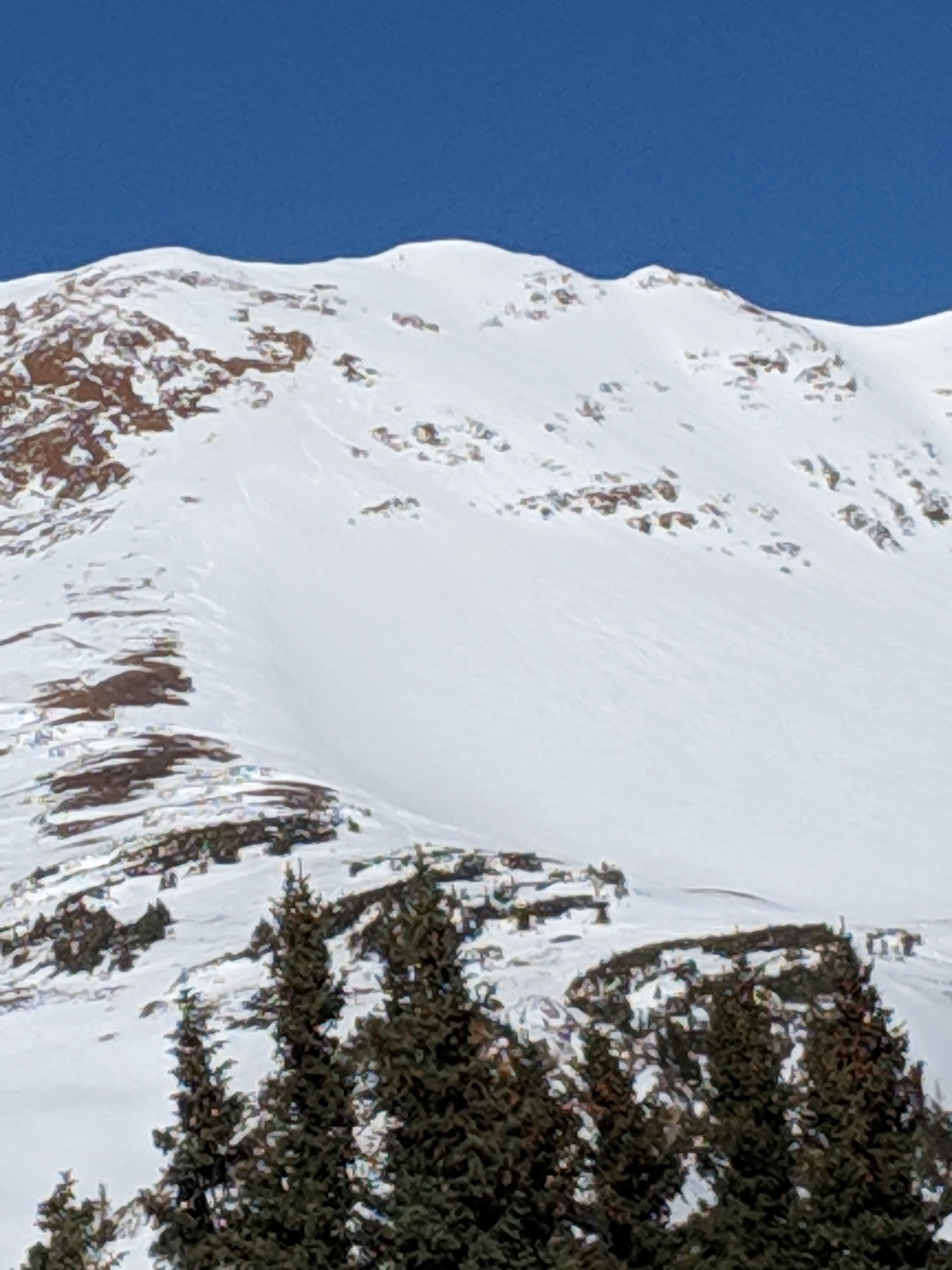
Observed one good natural slab that ran about 2,000 feet which likely failed during Sunday night, 11/4. The slab didn’t necessarily look that large, but the avalanche path holds a steep enough slope angle that allowed the debris to keep running and accumulating snow along the way. This avalanche probably started as a wind slab or cornice fall at ridgline around 12,600ft. Then those debris popped an estimated 200′ wide persistent slab just below a large cliff band that all continued on down for the rest of its journey.  This same piece of terrain produced a skier triggered slide on Saturday 11/3.  It released a bit to the lookers left and below the one pictured.  The observation for this avalanche can be found here.

Weather: Broken sky and generally protected from any wind.
Snowpack: Snowpack depth was sharky to 70cm on average, depending on elevation and on slopes exposed to previous wind events. The deepest and most suspect snowpack would have been on the true north facing slopes above 11,400ft. Winds associated with 11/4 had raked or pressed a lot of those more northerly slopes and loaded the more northeasterly slopes in this area. Observed new snow drifts up to 40cm, but the 11/4 storm probably brought in around 15-18cm’s HST at the upper elevations we were traveling in. The new snow felt slabby from the wind and sitting on junk that you could type another paragraph about.  Sandwiched in between the past few days snowfall and the faceted snow from the 10/9 and 10/11 snow events was a thin 1finger hard crust.  Outside of observing a good sized natural avalanche, we observed one large collapse that sent shooting cracks for 100-200′ on the deepest part of a slope, the shaded, most northerly facing, and further not stripped by recent winds… part of that slope. The slope angle at the cracks were at or above 40 degrees. The cracks didn’t appear to continue into the more northeasterly part of this slope.

Photos:

Eased into slope expecting a good collapse. Shooting cracks up the most shaded part of the slope along the left side of the picture and into the rocks above. Cracks didn’t appear to run out into the middle of the bowl. HS increased from ~40cm’s to ~90cm’s where we finally got the collapse.

NW Bowl Mt. Baldy

CB Avalanche Center2017-18 Observations, 2018-19 Observations

Location: Paradise Divide Area
Date of Observation: 11/04/2018
Name: Tom Schaefer

Subject: NW Bowl Mt. Baldy
Aspect: North West
Elevation: 12,300’

Avalanches:

Observerd one new avalanche that appeared to have happened that day crossing over a skin track mid bowl? Small wind loaded feature at aprox. 12,500’ below small cliff band. SS- N/O-R1-D1 O/G

Weather: Overcast in the AM becoming Obscured at 11:30. Winds West light BTL and Moderate near and ATL throughout the day. Snowfall rate increased from S1 at 11:30 to S5 at 1:45. Temps remained in the 20’s throughout the day.
Snowpack: Variable depths throughout NW bowl ranging from 10 cm to 90cm. Steep gully’s near ridges avg. 30 cm slippery wind stiffened surfaces. Below 12,000’ snow depth more consistent avg 90cm. with a fair amount of skier tracks on softer snow. Dug one quick hand pit at 12,300’ NW aspect HS 85cm and found 6 different weak layers from the ground up. Facet layer failed at 45cm with a hand shear test Q3.

Photos:

Reactive pockets

CB Avalanche Center2017-18 Observations, 2018-19 Observations

Location: Paradise Divide Area
Date of Observation: 11/04/2018
Name: Andrew Butterfield

Subject: Reactive pockets
Aspect: North East, East
Elevation: 12,500

Avalanches:

Plenty of sign of recent activity . Old debree piles were visible and felt on up-track. No concern until about 12,000′, after which we started experiencing some collapsing and cracking on wind-loaded pockets. Visibility was short, at times, and at one point I punched through a wind-loaded pocket (not visible at the time,) next to an old bed surface and caused a BIG collapse…probably enough snow to take somebody for a painful ride. Winds have been wreaking havok up there and certainly can present a big safety concern. With the new snow and wind, I imagine it may get worse. It’s early but please be advised to travel safely and be be weary of leeward slopes, as they are becoming reactive to ski-travel.

Weather: Gusty and variable wind.. 10-20 mph, mainly out of the west but variable direction and speed. Sun and cloud mix, periods of snow.
Snowpack: Roughly 2′ to ground, in the lower gully. In the alpine, closer to 3′. Probably an underestimated amount of snow from the night of 11/2-11/3 in the zone. We found pockets of fresh, drifted snow of up to 12″ on our tour today. Also, it snowed and “blowed” hard today (in periods) to contibute to the complexity.

Photos:

Ruby Range

CB Avalanche Center2017-18 Observations, 2018-19 Observations

Location: Kebler Pass Area
Date of Observation: 04/21/2018
Name: Evan Ross

Subject: Ruby Range
Aspect: South East
Elevation: 10,500-12,600

Avalanches:

Found the one wind loaded terrain feature on all of the south face of Ruby at about 11,000ft. D1 30-35cm windslab failing about 1cm above the old snow surface on non persistent grains.

Weather: Sun popping out in CB in the morning, but drove into the cloud heading out Kebler. Mostly cloudy sky in the morning become overcast by 10am with a cloud deck starting at about 10,800ft. Moderate northerly wind gusts at ridgeline. Full white out but didn’t observe any snow blowing about when I looked at my feet.
Snowpack: The new snow has settled into a thick 5-6″ at lower elevations. Climbing higher up a south aspect the new snow had either been pressed in by the wind or green housing, or blown off. Didn’t get onto the wind loaded terrain for a comparison at higher elevations. An experienced person fell off the same small cornice twice within 10 minutes. Sweet! classic. #whiteout

Photos:

Spring Pow. Axtell.

CB Avalanche Center2017-18 Observations

Location: Kebler Pass Area
Date of Observation: 04/20/2018
Name: Evan Ross

Subject: Sprin Pow. Axtell.
Aspect: North East
Elevation: 9,500-11,400

Avalanches:

D1.5 Sluffs in bigger terrain.

Weather: Snowing off and on with a bit of sun during the late morning. S2 at most. Couldn’t get a feel for ridgline winds due to trees, winds in the valley were blowing from the west or down valley up to moderate speeds during snow squalls.
Snowpack: About 8″ new at 11,000ft. Bonding well with the old snow surfaces. Didn’t get into much wind effected terrain . So sluffing in steep terrain was the only issue. Below 10,000ft the new snow was very thick.

Photos: