Name: Ross (Irwin Guides)
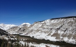
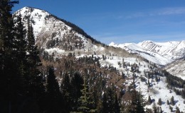
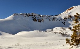
Location: Kebler Pass Area
Date of Observation: 12/09/2014
Aspect: North, North East, West, North West
Elevation: 12200-9000
Weather: Clear sunny day. Cold night with temps in the valley at 10f @ 7.30 temps increased with elevation. Strong solar, little to no wind at the ridge top of scarps. Doesn’t get much better than this from a temp stand point. more snow needed….please.
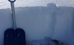
Snowpack: Thin snow pack at the top of scarps, 10cm. Obvious wind scouring on the ridge top. A mix of shallow facets and sun crust depending on aspects to the sun. Small cornice build up at the top of the ridge. Skied legends into peeler basin. Surprisingly supportive snow pack with no instabilities or sloughing seen. 10-15 cm of ski pen and excellent early season skiing. Variable snow pack depth ranging from 30-50cm of snow. Strong mid pack, supportive.
Snow pack decreased in strength and depth as you descended in elevation. Tried to ski northern facing slopes between Garfield and Peeler but low snow didn’t allow an access. Snow on the northern slopes leading into the ob be joyful basin at 11800 was thin, week and faceted. Skied across the SW face of peeler on a variety of sun crust and cold snow to access more northern slopes dropping into the ob be joyful basin. Week faceted snow ranging in depth from 30-40cm at 10500 to 25-30cm at 9700. Small facet sloughs observed on terrain greater than 30 degrees. A mix of sun crust and week facets exist on the valley bottom. Surface hoar is growing and exist in a variety of locations, deeper on shaded lower valley locations.