Mount Bellview

CB Avalanche Center2015-16 Observations

Location: Paradise Divide Area
Date of Observation: 11/08/2015
Name: Erin Kearns
Subject Mount Bellview 11/8/15
Aspect: North, East, South East, South, South West, West
Elevation: 9000′-12,400′

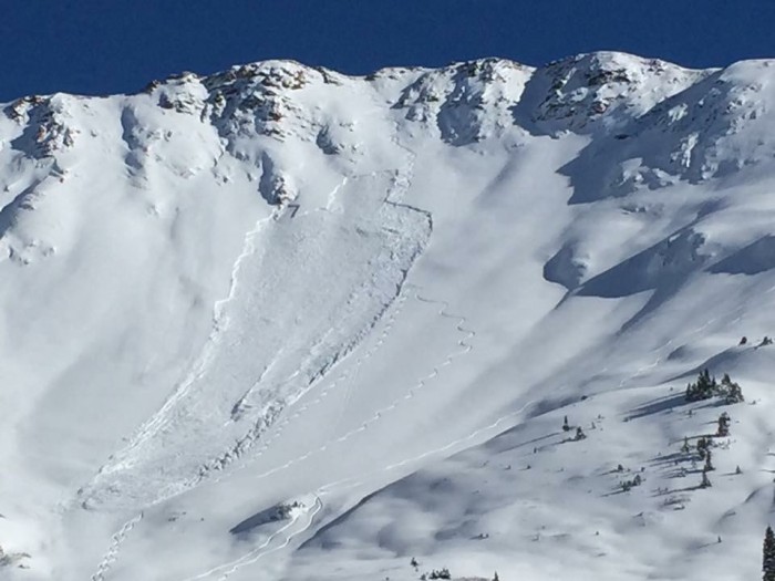
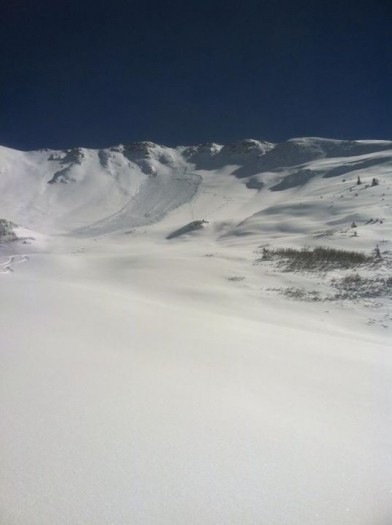
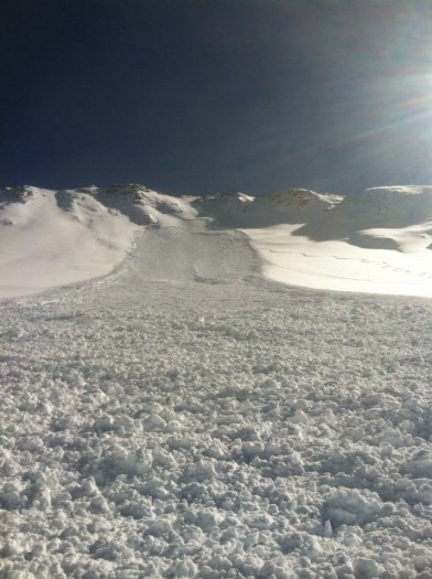
Avalanches: Small loose dry observed on NE aspect of Mt. Baldy
Weather: Mid-late teens early in the morning with temperatures rising steadily throughout the day and peaking in the mid 30’s around 12:30pm. Sunny, clear skies, calm wind.
Snowpack: -Saw a little bit of everything today on Mount Bellview.
-The most recent storm snow was settling, measuring 15-20cm deep in most areas. The exception was on the W-SW facing aspects, where it was significantly shallower (5-10cm)
-W-SW aspects appeared to have frozen into a crust the previous night, slow to soften throughout the day.
-Windloading occurring on S-SE-E aspects. Cornices beginning to form on all of these aspects. Wind slab forming at higher elevations mainly on the SE-E about 25cm deep.
-N Aspect: 3cm facets at the ground layer, buried by 2 interfaces (approx: 15cm each), each forming significant slabs. Lower slab was weaker and less cohesive than the upper.
-Heavy springlike conditions in the basin 12:30-1:30pm.

Cascade/daisy

CB Avalanche Center2015-16 Observations

Location: Paradise Divide Area
Date of Observation: 11/07/2015
Name: EM
Subject Cascade/daisy
Aspect: North East, East, South East, South, South West
Elevation: 9000 – 11400

Avalanches: No slab avalanche activity. Many steep cliff areas shed dry point releases during storm.
Weather: clear skies with very occasional light winds. Temp was 8 f at 9am at TH. temp in the sun at 11400 was 35 f at noon.
Snowpack: On sunny aspects the snowpack consisted mostly of new snow with only a few patches of old crust underneath higher up. Shaded aspects had 1mm facets underneath new snow. One location on a ENE 35* roll at 11200 had 5cm basal crust , 35cm 1mm facets, 45 cm new snow. Tests showed both interfaces had not bonded well. Snowpack overall showed signs of settlement which made riding conditions more supportable. Noticed only small amount of wind effect snow up high on NE flanks of Richmond.

Skier Triggered Slab Avalanche on Baldy

CB Avalanche Center2015-16 Observations

Location: Paradise Divide
Date of Observation: 11/07/2015
Subject Skier Triggered Slab Avalanche on Baldy
Aspect: North
Elevation: Above Treeline


Avalanches: On a north facing bowl on Mt Baldy. SS-AS-R2-D2-O

Photo credit Austin Gibney

Obs

CB Avalanche Center2015-16 Observations

Location: Kebler Pass Area
Date of Observation: 11/07/2015
Name: Steve Banks
Subject Obs
Aspect: South West
Elevation: 12000

Avalanches: SS-N-R2-D1 noted in the saddle between Ruby and Owen. Looks to have run mid storm. Some debris piles noted on the East faces of Ruby and Owen looks like dribblers that also ran midstorm.
Weather: Sunny, hot! +4 at 11 am at 12,000′. Calm winds becoming light from the West afternoon.
Snowpack: Average about a foot of snow, rapid settlement throughout the day. Intermittent old snow either 4-6 cm of 1-2mm facets or an old crust. Mostly just the new snow. Near surface facets noted in the cold morning, gone by afternoon. Full snowpack was moist by 2 pm.

Irwin Snow obs

CB Avalanche Center2015-16 Observations

Location: Kebler Pass Area
Date of Observation: 11/06/2015
Name: Havlick
Subject Irwin Snow Obs
Aspect:
Elevation: 10,200 ft

Snowpack: Last 24 hours: 6″ at .5″ SWE
Storm total: 18″ at 1.45″ SWE
Density inversion 4″ below the surface. Gusty WNW winds and 3-4′ drifts.

Touchy Conditions on Mt. Baldy

CB Avalanche Center2015-16 Observations

Location: Paradise Divide Area
Date of Observation: 11/05/2015
Name: Zach Guy
Subject: Touchy Conditions on Mt. Baldy
Aspect: North East, South East
Elevation: 10,000 – 11,700 feet

Avalanches: Skier triggered one soft slab on a NE feature above treeline that failed on the storm interface about 15″ deep, on faceted snow. Small in destructive size. SS-ASc-R1-D1-I. See photo.
Weather: Light snowfall continued all day, with pulses of moderate snowfall. Calm winds. Overcast skies.
Snowpack: Storm snow depths increased from 10″ at 10,000 ft to 20″ at 11,700 ft in a NE facing bowl. Fist hardness and right-side up, but cohesive enough to form a soft slab. No signs of instability where the storm snow fell on dirt. At 11,300 ft, we first encountered old snow layers at the bottom (1mm facets), and immediately began seeing shooting cracks (~5 feet in length) and getting soft collapses. When we ventured to SE facing slopes which held melt-freeze crusts at the bottom of the snowpack, we did not see any signs of instability, and the new snow appeared to be bonded well to the storm interface. No signs of significant wind transport, but we stayed low in the bowl and avoided the higher, potentially wind-loaded ridgelines.

Triggered Wind Slab on Mineral Point

CB Avalanche Center2015-16 Observations

Location: Paradise Divide Area
Date of Observation: 10/31/2015
Name:
Subject Triggered Wind Slab on Mineral Point
Aspect: East
Elevation: Above treeline

Avalanches: 2nd hand report to CBAC of a wind slab triggered while climbing on the east face of Mineral Point. The crown was roughly 1 foot deep and estimated 20-40 feet wide, on a windloaded terrain feature, D1 in size but large enough to carry you over cliffs

avalanche photo

IMG_1335

Halloween in Paradise

CB Avalanche Center2015-16 Observations

Location: Paradise Divide Area
Date of Observation: 10/31/2015
Name: Dustin
Subject Halloween in Paradise
Aspect: South East, South, South West
Elevation: 11,200-13200

Avalanches: Saw a previously triggered (assumed to be natural) wet loose/slab on a SSE aspect R1 D1 with a crown around 3-4 inches. Also skier triggered a wet loose R1 D1 on a SW slope with exposed rock nearby.. Slide started small but pinwheeled and picked up snow on 5-10cm crust on the ground.
Weather: Sunny and breezy with clouds increasing during the day. Little snow transport witnessed.
Snowpack: Snowpack is largely on slopes that were loaded from the storm earlier this week with strong NW winds. Many windward slopes blown clean of snow. The base of the pack on solar aspects ranges from crusts on the ground to no snow at all. This was topped with a dense wind slab of varying thickness dependent on the slopes’ relation to the wind. The small dusting of new snow sat on top.

Treasury Mountain Surface Obs

CB Avalanche Center2015-16 Observations

Location: Paradise Divide Area
Date of Observation: 10/31/2015
Name: Zach Guy
Subject Treasury Mountain
Aspect: North, South
Elevation: 11,500 to 13,000 ft.

Avalanches: No signs of instability except for very shallow and isolated cracking in areas with recent wind drifting (only a couple inches deep) Not much in the way of avalanche concerns.
Weather: Few clouds. Moderate to strong ridgetop winds from the NW, but no snow transport.
Snowpack: Continuous snow coverage begins around 11,000 to 11,500 feet, and is spottier on south aspects. Total snow depth is generally less than 10″, but up to 2 -3 feet in windloaded areas. On southerly aspects, the snowpack is comprised of one or multiple stacks of crusts, with 1-2mm facets below or between in some locations. The surface became moist today. On northerly aspects, the snow surface is a mixed bag of wind crusts, sastrugi, dense rounds and near surface facets, all showing signs of surface faceting. The snowpack is mostly rounded and relatively dense, except in the shallower, wind protected areas which have 1 mm facets throughout.

photo of purple ridge

Snow coverage on northerly aspects of Purple Ridge

Snow coverage on the west side and north side of Mt. Baldy and surrounding peaks

Snow coverage on the west side and north side of Mt. Baldy and surrounding peaks