Mountain Weather 12/11/15

CB Avalanche CenterWeather

Date: 12/11/2015

Just when we didn’t think it would ever snow again, the weather forecasts have some interesting changes in store through the start of next week. Currently there is a low pressure trough approaching from the west and a cold front stalling over northern Colorado. A number of weather factors are combining to produce enhanced snowfall numbers north of I-70 and I don’t know if it’s the weather forecasters that are more exited or those locals.

For our area we’ll have to mostly really on orographic snowfall from southwest flow for today’s accumulations. So we should pick up a few inches mainly west of Crested Butte today with continued strong winds from the Southwest. Late this afternoon and tonight we’ll get our share of enhanced snowfall before things start to quiet down as Saturday progresses. Winds will finally start decreasing also on Saturday as the low pressure trough moves over Colorado. A weak high pressure ridge will build as the trough heads east before the next system moves in early next week.

Mountain Weather 12/10/15

CB Avalanche CenterWeather

Date: 12/10/2015

High level clouds and winds will increase under westerly flow ahead of an incoming Pacific system bringing deep moisture. Favorable jet dynamics and a cold front are forecasted to stall over northwest Colorado, leaving us out of the bulls-eye for Friday’s snowfall. The influences of the jet won’t miss us though, with strong to extreme alpine winds at the front end of this system. The cold front then pivots through the Elk Mountains on Friday night, boosting snowfall and pushing our snowfall totals closer to a foot on Saturday in favored locations. A transitory ridge follows behind on Sunday, bringing a lull in weather before another system arrives Monday, bringing continued snowfall.

SH on the snow surface

CB Avalanche Center2015-16 Observations

Location: Kebler Pass Area
Date of Observation: 12/09/2015
Name: Ben Pritchett
Subject: SH on the snow surface
Aspect: North, South
Elevation: near and below treeline

Snowpack: Surface Hoar widespread in Anthracites. 2-3mm SH on the sunnies, 5-7mm SH on the shadies. Still barely supportive on lower angled slopes; facet wallowing on steeper terrain. The Dec 10th or 11th interface will likely be a player for a while to come!

Ruby Range Obs

CB Avalanche Center2015-16 Observations

Location: Kebler Pass Area
Date of Observation: 12/08/2015
Name: Ian Havlick
Subject: Ruby Range Obs
Aspect: North, North East, East, South East, South
Elevation: 10-13,000

Avalanches: 2 recent cornice falls off Owen and Purple ridgelines. No avalanches triggered from these events. Dropped a fairly large cornice and pryed off 10′ wide, 10″ windslab.
Weather: Low ceilings, flurries disapated into broken then partly cloudy skies as day went on. Steady 10-20mph west winds at ridgetop.
Snowpack: Generally stable conditions, even in steep and extreme terrain. no snow transport. Pits and probing indicated gradually increasing hand hardness with depth, HS 10-11000 averaged about 70cm, smow in NE cirque of Mount Owen averaged 150-300cm. One pit, CTN @ 11,000, E-facing, 35º.

Cornices on ridgetop are tenuous and rotting out at roots.

Mountain Weather 12/9/15

CB Avalanche CenterWeather

Date: 12/09/2015

Breezy but dry conditions will persist for the next two days as the storm track and jet stream remains to our north. Weak disturbences embedded in northwest flow will bring increased cloud cover tonight and tomorrow but sno w is unlikely. A Pacifc trough impacts our region on Thursday night into Friday. A slow moving cold front, along with jet and orographic support will combine to produce a decent shot of snow and wind to carry us into the weekend. Accumulations are roughly looking like a foot in favored locations, with half of that or less closer to town.

Mountain Weather 12/08/2015

CB Avalanche CenterWeather

Date: 12/08/2015

A weak embedded wave under northwest flow will bring an increase in cloud cover and maybe a few snow flurries in our peaks today. We’ll see dry conditions follow suit until another weak disturbance brushes to our north Wednesday night. The heavy hitters arrive on Friday into the weekend, but models are showing some disagreement on how to handle this incoming Pacific trough. Details to come later this week.

Weak snow on Mt. Emmons

CB Avalanche Center2015-16 Observations, Snow Profiles

Location: Crested Butte Area
Date of Observation: 12/07/2015
Name: Zach Guy
Subject: Weak snow on Mt. Emmons
Aspect: North, North East, East, South East
Elevation: 9,500 – 12,000 ft

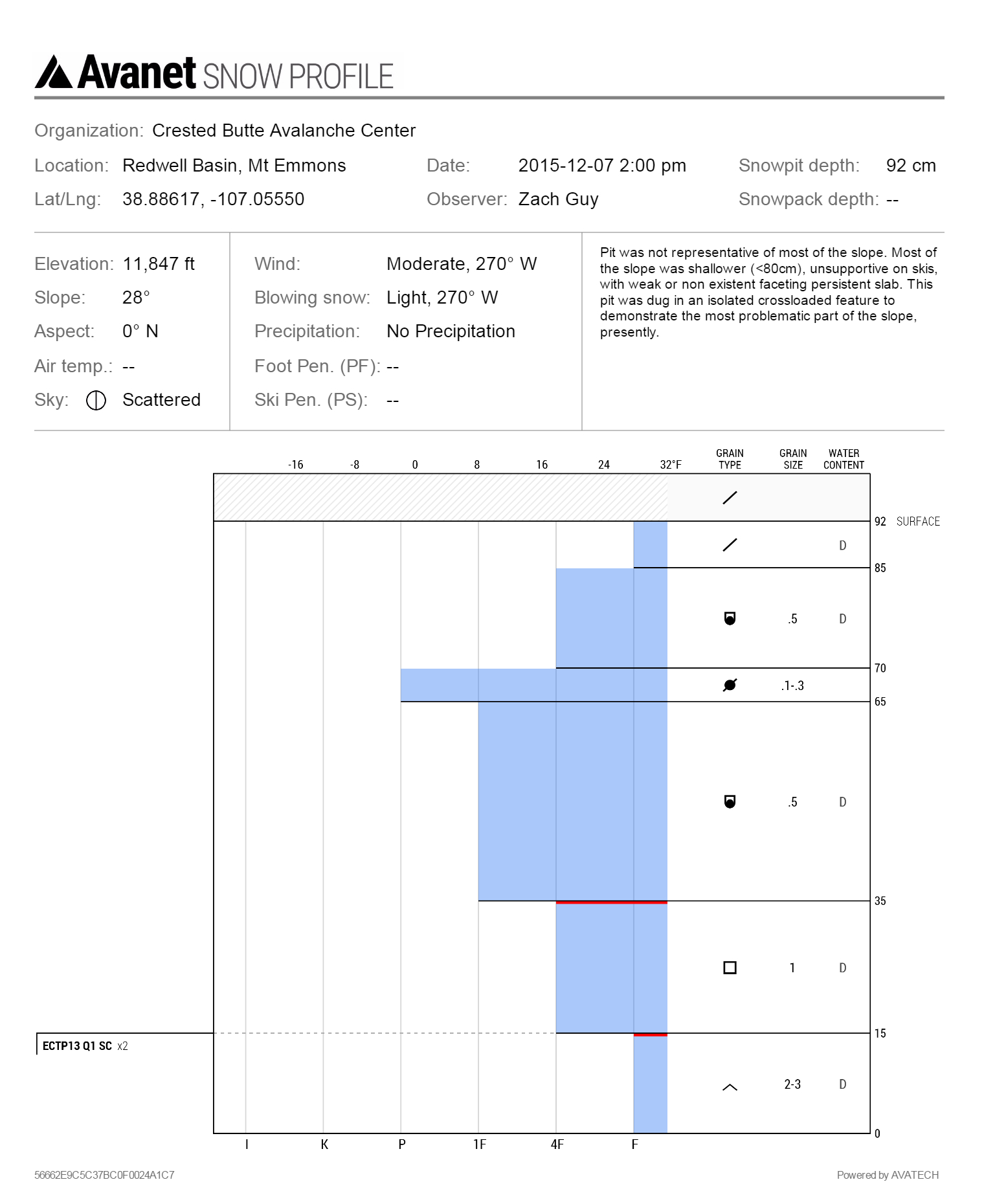
Avalanches: We triggered cracking and a very small windslab avalanche, 4″ deep x 15 feet wide, on several windloaded rollovers facing SE. Also some small cracks where the persistent slab structure was shallow (<20 cm) but stiff from wind.
Weather: Scattered, thin clouds. Moderate to strong westerly winds with light snow transport at ridgetop. Mild temps, no precip.
Snowpack: In summary, widespread weak and faceted snowpack on all aspects, with decaying and unreactive persistent slabs except in isolated, heavily windloaded features. See video
Below treeline: Snowdepth is less than 30 cm, entirely faceted, fist hardness on all but southerly aspects. Ski pen to the ground. Most southeast through southwest aspects are bare, or hold shallow stacks of melt-freeze crusts with varying degrees of faceting between crusts.
Near treeline on N to E aspects: Snowdepth ranged from 40 to 80cm, with fist hard facets in the lower half, and in windloaded areas, faceting slabs in the upper half (4F hardness). No results in snow pits. Ski pen was trap-door, nearly to the ground.
Above treeline on N to NW aspects: Predominately thin snowpack due to wind erosion, <60 cm, and faceting throughout, with ski pen near the ground.  Isolated and discontinuous pockets of supportive snow with 1F to 4F faceting slabs over softer facets, similar to near treeline, but stiffer and thicker in the more heavily windloaded features.  In one crossloaded gulley, the snowpack was 100 cm deep and showed propagating test results on depth hoar near the ground.  On SE aspects ATL, we found thick, supportive crusts on steep (~40*) slopes, and an entirely faceted snowpack with thin, breakable midpack crusts as the slope angle lowered to mid 30’s. No slabs on this slope.

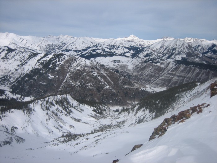
Above treeline, North aspect on Mt. Emmons
Near treeline, NE aspect on Mt. Emmons.
IMG_5340
More bare slopes than snow covered on SE, S, and SW aspects below treeline, looking toward Schuykill Ridge, Anthracite Mesa, and Snodgrass.

Mountain Weather

CB Avalanche CenterWeather

Date: 12/07/2015

Today’s weather will be similar to yesterday with strong valley inversions this morning, slowly easing as the day goes on. High clouds will filter into the area throughout the day as weak ripples in the jet stream bring high level moisture overhead and gusty winds at mountain top level. The weekend’s storm continues to evolve but continue to see model agreement that potential snowfall could range between 10-20” accompanied by strong winds. Each day, and each model run we will see details on timing and strength clarify, so stay tuned.

Poverty Gulch Dec. 6

CB Avalanche Center2015-16 Observations

Location: Paradise Divide Area
Date of Observation: 12/06/2015
Name: Dustin Eldridge
Subject: Poverty Gulch Dec. 6
Aspect: North, North East, East, South East
Elevation: 9,600-12,000

Avalanches: Just saw the previously mentioned point-releases.
Weather: Cold start at the TH in the morning but temps quickly warmed as we climbed out of the valleys. Saw multiple point-releases from E-facing rockbands. West and Southwest winds became gustier in the afternoon and moderate snow transport was occurring on ridgetops.
Snowpack: Started climbing up E-facing slopes below treeline and found surprisingly deep snowpack in areas (up to 120 cm). Around 15-20 cm of storm snow sat on a very firm crust and snow was easily sliding on this interface. No evidence of slabbing or cohesion in the storm snow at any elevation. The N-NE snowpack around 11,600 showed a burly pack averaging around 150 cm of snow. The lowest spot found was 70cm in a more wind affected area and the highest was over 220 cm. Storm snow was 20 cm and more in this area and elevation. Snowpack felt rather consolidated and uniform throughout. The exception was on more westerly facing slopes that received a stiff wind slab from recent NW winds. Below this was 5-15 cm of softer snow with another stiff slab below.