Purp Skurp

CB Avalanche Center2016-17 Observations

Location: Paradise Divide Area
Date of Observation: 12/01/2016
Name: Dustin Eldridge
Subject: Purp Skurp
Aspect: North, North East, East
Elevation: 9500-11500

Avalanches: Saw a few old, blown-in crowns out in the distance of Baxter Basin and the north face of Cascade.
Weather: Day started relatively warm (10-15f) and continued to warm as the day went on. Partly cloudy skies began to creep in before the noon hour and by 1-2 skies became more overcast. Wind picked up a little bit in the afternoon but snow transport was very minimal. Definitely had a few instances of getting ‘greenhoused’, and saw some roller balls. Otherwise, sun’s impact on snow was limited.
Snowpack: Snowpack seems to be settling well. Ski pen is around 15-20 cm. Pack grew from 60-70 cm on E and NE slopes towards the valley floor to around 110-120 cm getting closer to treeline. Mostly right-side up, with a small crust-facet combo found in the basement of our NE facing pit at around 11,200 feet. CT21 and CT24, both Q1 shears at around 75 cm from the bottom. Weak layer was hard to identify from the pit wall, I imagine it was either a small layer of near-surface facets or surface hoar; did not notice much of a density change at the weak layer. Otherwise, no signs of instability noted.

IMG_4776
IMG_4774

Mountain Weather 12/2/2016

CB Avalanche CenterWeather

Date: 12/02/2016

We will see mostly cloudy skies with light snow developing throughout the day before tapering off this evening. Just a a few inches of snow can be expected by this upper level disturbance passing over the central Rockies. Winds look well behaved, light northwest winds up high. For the weekend, we dry out with warmer temperatures and strong sun before a good shot a snow early next week. Water cooler snow estimate… 6-12” by next Wednesday, 18” at Kebler/Schofield. Just to make things interesting..

Mountain Weather 12/1/2016

CB Avalanche CenterWeather

Date: 12/01/2016

Today we will see cold air advection from a weakening disturbance bring continued cloudiness and light orographic snowfall to the spine of the Elk Mountains. Winds should remain light, and temperatures frigid. Looking ahead, a few more embedded ripples of moisture will keep stubborn clouds and snow showers over the highest terrain until Saturday, when the atmosphere temporarily dries out before a much more promising, possibly significant storm arrives early next week.

Schuylkill Peak avalanche and snowpack obs

CB Avalanche Center2016-17 Observations

Location: Paradise Divide Area
Date of Observation: 11/30/2016
Name: Zach Guy
Subject: Schuylkill Peak avalanche and snowpack obs
Aspect: North East, East
Elevation: 9,500 – 11,700 ft

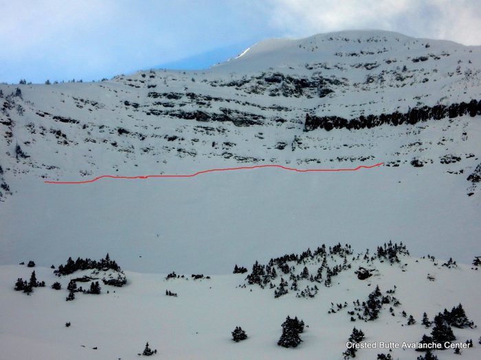
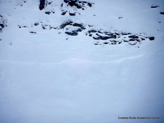
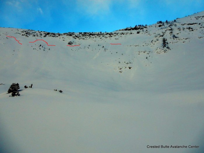
Avalanches: Multiple crown lines across the N/NE/E bowl of Schuylkill Peak, faintly visible because they ran naturally mid storm. Hard to tell whether they originally connected or were separate slides. Debris was completely smoothed over by snow and wind. I would estimate they were D2 in size, failing on old snow layers near the ground. Vis of surrounding terrain was obscured by clouds, so no other avy obs.
Weather: Calm winds in basin. Light snow transport observed at peak summit. Cold temps. Scattered to broken skies.
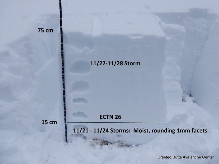
Snowpack: On E to NE aspects.: Snow depth increased from 75 cm below treeline to 115 cm above treeline, with settled recent storm totals ~60 cm below treeline, and variable above treeline due to wind drifting.
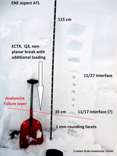
Below treeline, the snowpack was generally right side up, with moist 1mm rounding facets at the ground and a soft 60 cm slab above. The base of the snowpack began to feel increasingly hollow with elevation gain, but no sharp hardness changes. Hand pits showed dry 1mm facets near the ground below a 60-70cm soft slab. No cracking or collapsing observed on numerous small, steep rollovers near and below treeline. The bowl above treeline appeared to have mostly avalanched naturally, leaving a snowpack of ~20 cm of post-release fist hard snow over grass/talus

NE Aspect BTL

NE Aspect BTL

Crownline on ENE face of Schuylkill Peak

Crownline on ENE face of Schuylkill Peak

Zoom in of crown, ENE aspect

Zoom in of crown, ENE aspect

Faint crown lines, N aspect of Schuylkill Peak

Faint crown lines, N aspect of Schuylkill Peak

Crown line profile, ENE aspect ATL

Crown line profile, ENE aspect ATL

Mountain Weather

CB Avalanche CenterWeather

Date: 11/30/2016

We’ll see mostly clear to partly cloudy skies today under chilly and dry northwest flow. A shortwave trough drops out of the northwest tonight, increasing cloud cover tomorrow and spreading light snow showers to the Elk Mountains by tomorrow night. Look for a few inches out of this system. The storm track dives to our south this weekend keeping the weather unsettled but little in the way of snow accumulations.

Thanksgiving and avalanches

CB Avalanche CenterAvi Blog, Avi-Off-Season

Thanksgiving and avalanches. By Zach Guy
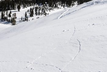

Shooting cracks are a sign that the snowpack might have taken a few too many scoops of mashed potatoes and stuffing.

It has been a wonderfully warm and dry fall, which is hard to complain about. But if we can be brutally honest with the weather gods, fall really was starting to wear out its welcome, and we are happy to open the door to winter. There’s nothing quite like surfing over powder, so it’s time to dust off those skis, find your beacon, shovel, and probe, and start tuning into our daily avalanche reports.

Early season skiing and riding comes with some challenges and risks. The snow coverage is still quite shallow, so striking rocks and logs are tough to avoid and they can end your season pretty quickly. My strategies include getting on the fattest skis I can find, riding like a gaper in the backseat, and using releasable bindings in case my tips dive under a log or rock. I’ve seen a few too many broken tib-fibs from early season riding. And of course, we all want to go to where the snowpack is deepest, which can open the doors to another scary threat: avalanches. This time of year, the slopes holding deep and continuous coverage often carry the greatest risk of triggering an avalanche. It is almost impossible to go through fall without a shallow, crusty, and faceting foundation forming on the ground. Then once we start building a deeper snowpack, it creates a persistent slab avalanche problem above these layers.


Skier triggered slides in Red Lady Bowl

I like analogies, so let’s compare our current year’s snowpack to your most recent Thanksgiving celebration. You probably avoided food all day, maybe even went for a turkey trot to work up an appetite in preparation for the big feast. A significant drought, indeed. That left you weak and frail, just like the lingering snowpack layers that survived our fall drought. Then once dinner time (i.e. winter time) rolled around, you started off at a decent pace. Snacked on some hor devoirs, some salad, maybe some of your Uncle’s famous deviled eggs or your Grandma’s bean dip. Our first few storms behaved in similar fashion, fairly small and steady loads, with a handful of isolated avalanches. Nothing too scary yet. Then it is dinner time: you go for the mash potatoes, stuffing, turkey, green bean casserole, and of course drown it all under gravy. Extra rolls? Why not? Whammo. That’s a heavy load, just like our last storm, which dumped almost 2 feet in places. Both scenarios are dangerous. You could collapse on the couch just as easily as you could collapse those fragile weak layers near the ground. During and after the storm, we saw both natural and skier triggered avalanches, some quite large and surprisingly wide. As of Tuesday night, I’m expecting we’ll see evidence of a lot more avalanche activity as we get better visibility over the next few days. So tread carefully out there, and check the avalanche report before you go out. So what’s next for our snowpack? Does it reach for another plateful of mashed potatoes before slamming down some pumpkin pie and faceplanting onto the floor? Or does it slowly nibble at the leftover turkey and try to stay awake for family charades? Only the weather can dictate that one. But you can be the captain of your risks by making rational decisions and practicing your rescue skills. Is it a coincidence that this Friday night is our Annual Avalanche Awareness Night, with the theme “Human Factors and Decision Making”? Or that Saturday is our annual Beacon Brushup, a free and valuable opportunity to dial in your rescue skills for the winter? I think not. See you there!

Red Lady Avalanche

CB Avalanche Center2016-17 Observations

Location: Crested Butte Area
Date of Observation: 11/29/2016
Name: Tony Martin
Subject: Red Lady Avalanche
Aspect: South East
Elevation: Above treeline

Avalanches: Saw 2 skiers thru my telescope on top red Lady at 11:40 AM. First skier triggered a large avalanche after appx. 10 turns that ran from appx. 50 yards below the summit down to the flatter area / several hundred yards below the summit. It broke slightly above and 20 yards skiers right of the skier (skier not caught).
Hard to tell from here how wide it was from here, but guesstimating 75 to 100 yards in width
Weather:
Snowpack:

Avalanches around Crested Butte Area

CB Avalanche Center2016-17 Observations

Location: Crested Butte Area
Date of Observation: 11/29/2016
Name: Zach Guy
Subject: Avalanches around Crested Butte Area
Aspect: North East, South East
Elevation: Above treelin

Avalanches: See photos. 2 large natural slab avalanches that ran sometime during the storm on NE aspects above treeline, Mt. Emmons and Mt. Axtell, both failing at the ground in old snow layers. Both showed impressive propagation considering relatively thin slabs. 2 slab avalanches that occurred mid-day on SE aspect ATL of Red Lady, apparently remotely triggered by a skier. These presumably failed on a crust or crust facet layer from that formed last week, either at the storm interface or just below it.
Weather: Clearing skies allowed views of peaks near town.
Snowpack: No avalanche activity observed on any of the N/BTL paths near town, but they now appear to have a smooth and continuous snow cover for future weak layer/bedsurfaces

Mt. Axtell. NE Aspect ATL.  SS-N-R2-D2-O/G
Mt. Emmons.  NE Aspect ATL  N-SS-R1-D1.5-O/G
Mt. Emmons, SE Aspect ATL.  SS-ASr/y-R1-D2-U

Mountain Weather

CB Avalanche CenterWeather

Date: 11/29/2016

Colorado is now in the backside of the trough that brought significant snowfall since Sunday morning. Radar is picking up a few waning showers upstream of us, and northwest to north orographics could wring out a final inch or two, but you snow dancers can take a breather for the moment. The next trough is fast on its heels, digging into the Great Basin this Friday. Between now and then, we’ll be sitting in a cold, gradually drying air mass.