The broad trough that brought our active weather earlier this week is shifting eastward across the U.S., and Colorado sits on the front end of the next feature, a broad ridge. Northwest flow will keep temperatures cool today, with a warming trend into the weekend. You’ll be burning through your sunscreen supplies until Monday.
Location: Crested Butte Area Date of Observation: 03/01/2017 Name: Steve Banks/ Mike Soucy
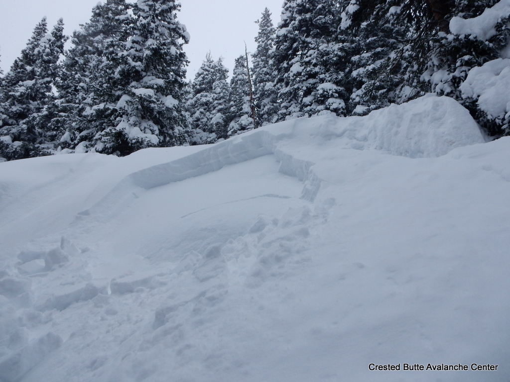
Subject: Snodgrass Aspect: North East, East Elevation: 9,300-11,200
Avalanches: Many fresh avalanches noted above treeline on Gothic, SE face of Mt. Belleview, both sides of Angle Pass, Wolverine, Redwell and East side of Scarp Ridge. All D2 and Easterly aspects with extensive propagation running up to 1000 vertical. Also saw crowns on Schuylkill Ridge but didn’t see the extent. Weather: High of -8 but strong solar made it feel much warmer. Light winds with some plumes noted off the high peaks. Snowpack: New snow settling well and stiffer due to last nights winds.
1 test profile to check the buried NSF at 10,200 NE below the Snodgrass saddle with 35 cms of new and CT 1 SC. Spooky.
Some small, localized collapses on the skin up in terrain around 30 degrees.
Thin zipper crust on S/SE slopes in the afternoon even at 11,000′.
Location: Kebler Pass Area Date of Observation: 03/01/2017 Name: Ian Havlick / Irwin Guides
Subject: Naturals in Ruby Range Aspect: Elevation:
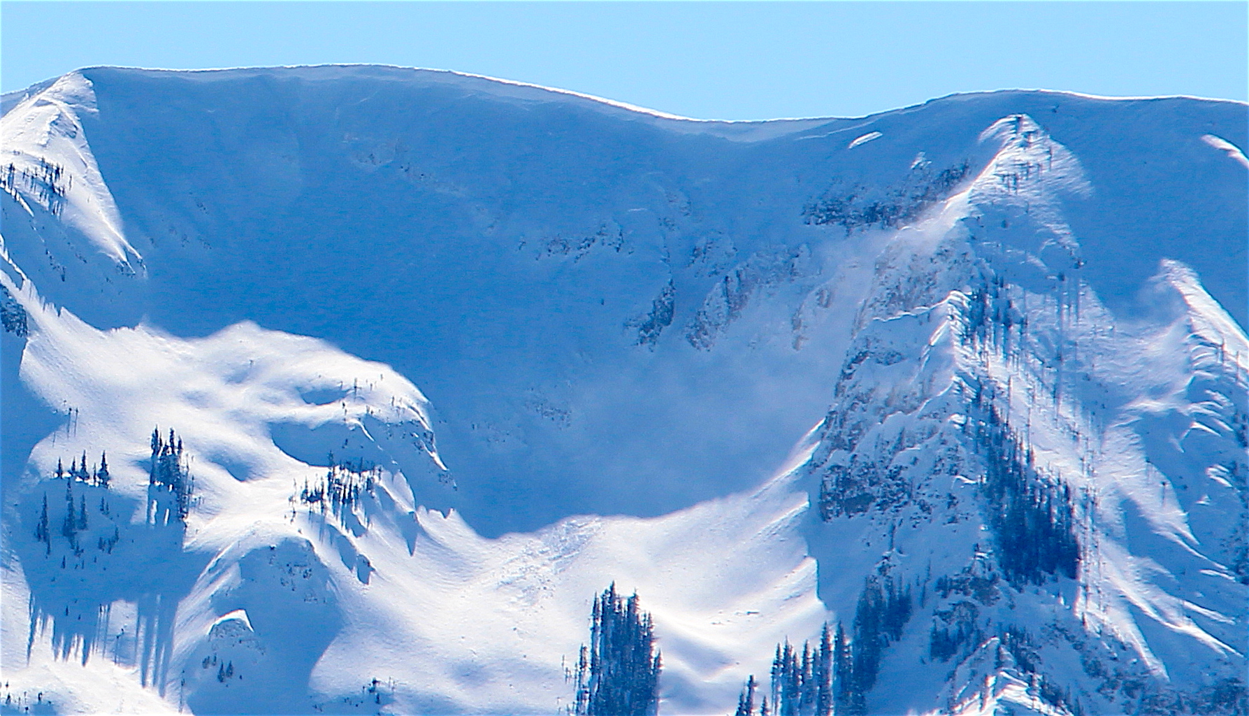
Avalanches: Big slides on Marcellina, Afley, Beckwith, and Ohio Peak, several feet deep and wide propagation. Weather: Calming winds from previous days, but still cold and blustery especially at ridgetop. Minor wind transport. Snowpack:
Location: Brush Creek Area Date of Observation: 03/01/2017 Name: Zach Guy
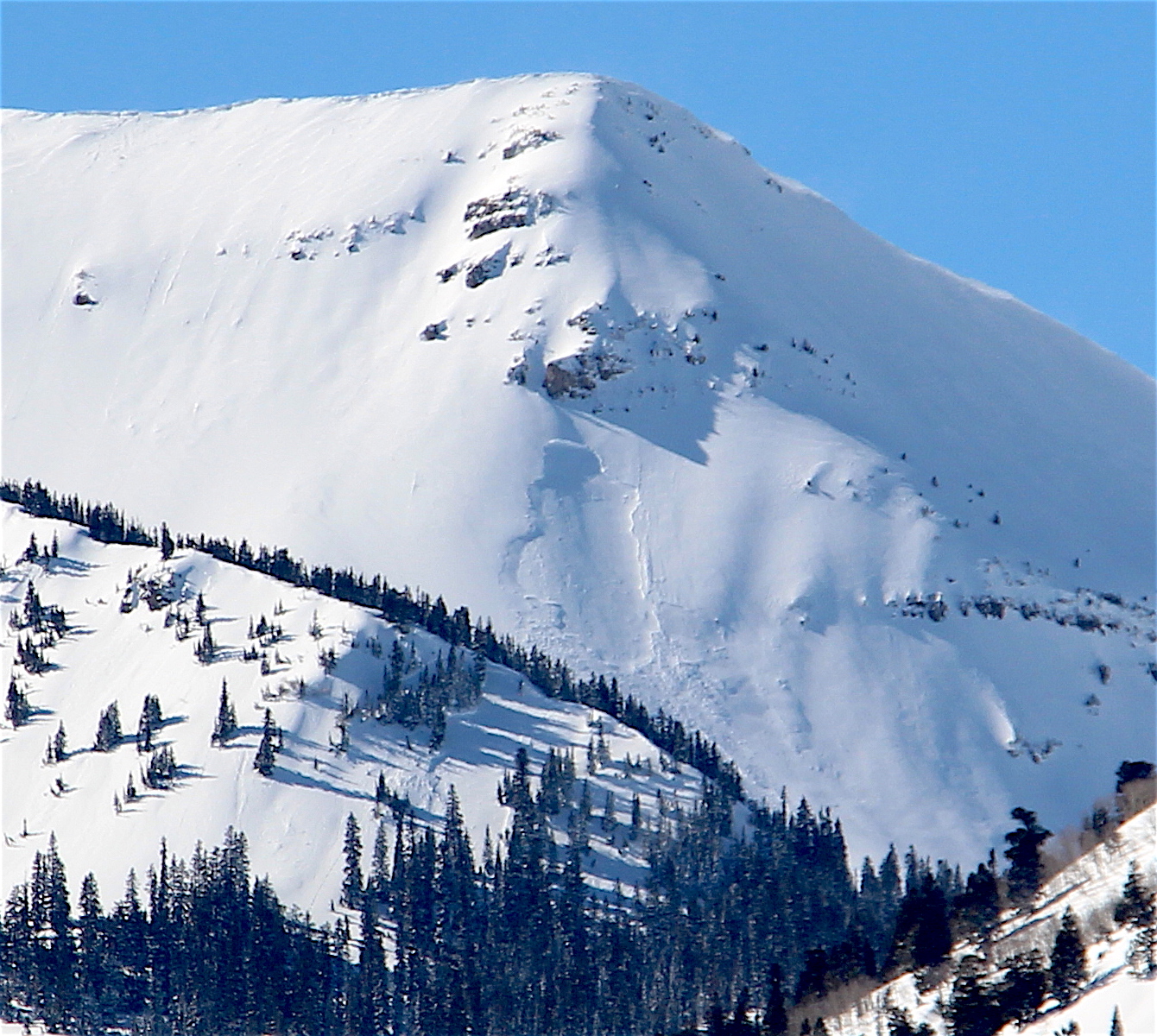
Subject: Natural avalanches ATL Aspect: North East, East, South East Elevation: 9,300-12,800
Avalanches: Numerous natural D1 to D2 soft slab avalanches, mostly on easterly aspects above treeline (NE to SE). Based on crown thicknesses and snow structure obs, I assume that most of these failed on the crust/facet layers buried about 18-24″ thick. There were also a few D1 shallow wind slabs. See photos. Weather: Cold, clear, light winds with no transport. Snowpack: Below treeline, 12-18″ of soft slab down to the concerning persistent weak layers (crusts/facets).
Above treeline, highly variable slab thickness and distribution due to westerly winds. Most westerly aspects are scoured away. One crown profile on an ESE aspect showed 20″ of F to 4F slab over a thin melt-freeze crust with 1-2mm facets above and below. Extended column failed on isolation (ECTPV, SC).
D2 NE aspect NTL. X Chutes on Whetstone. Ran a long way.
D2 E aspect near White Rock Mountain.
D2 E aspect ATL. Near White Rock Mtn
2xD1.5 NE aspect Double Top
D1.5 NE aspect Double Top
ECTPV on 1-2mm facets below a 1 cm MFcr, 50 cm deep. ESE aspect ATL.
D2. SE aspect Hunter Hill
D1.5 SE aspect Hunter Hill
D2. NE aspect Double Top.
D1.5 E aspect Hunter Hill
D2. SE aspect Timbered Hill
D1.5/D2’s. E and NE aspects above West Brush Creek
Location: Brush Creek Area Date of Observation: 02/28/2017 Name: Zach Guy
Subject: Reactive persistent slabs and sluffs Aspect: East, South East Elevation: 10600-11600
Avalanches: Skier triggered numerous loose snow avalanches in the top 12″ of the storm snow, up to D1.5 in size. Remotely triggered a small rollover from below, failed about 20″ deep on the 2/17 facet layer. SS-ASr-R1-D1-O. Poor vis, no other avalanche observations. Weather: S-1, Overcast to broken skies, winds increased through the day, becoming strong and transporting lots of snow. Snowpack: 18″ of storm snow at Friends Hut. The top 12″ came in very low density (~3%). Widespread loose snow instabilities, but the storm snow became slabbier through the day due to settlement and wind affect. Persistent weak layers (near surface facets and thin crust/facets) were reactive: multiple moderate collapses, a 100′ shooting crack, and remote triggered a small pocket, all on buried facets about 18-24″ deep. The most concerning structures were on ESE and E aspects, where there are thin crusts surrounded by facets.
Location: Crested Butte Area Date of Observation: 03/01/2017 Name: Arden Feldman
Subject: Avalanches on Easterly Aspects Throughout the Zone Aspect: North East, East, South East Elevation: ATL, NTL, BTL
Avalanches: Many natural D1-D2 soft slabs on northeasterly and easterly ATL/NTL slopes. One natural D2.5 slab on a southeasterly/easterly aspect of Mt. Bellview. One natural D1 storm slab BTL on an east aspect. Skier triggered a D1.5 storm slab yesterday (2/28), on a steep northeasterly slope NTL.
See email for pictures Weather: Clear skies with light winds and warming temps. Some snow blowing off the high peaks. Snowpack:
Temperatures bottomed out in the single digits below zero this morning, and will struggle to break the upper teens as clouds linger and limit daytime heating across higher terrain favored by residual northwest flow. Yesterday’s storm system has moved eastward, and aside from the higher peaks, we will see generally sunny skies for most of the forecast area. Moderate west winds will drop off this morning, leaving forgivingly light winds to treat those able to enjoy the backcountry today. Looking ahead, sunshine and a gradual warming trend will bring us into the weekend. The next potential for a shot of snowfall looks like Sunday, but accumulations look light at this point.
Avalanches: Weather: Here are the 24 hour totals (earlier I gave only overnight). There was 8 1/2″ new with water 0.77″ and snowpack now at 90″. Snow has become light and temp. holding at 19F. No visibility. I am tired. billy Snowpack:


 new world, godzilla natural. looks windslab intiated deeper instability, maybe crust facet combo or deeper
 2nd peak back in center of photo, large, almost basin-wide, multiple foot deep crown. in sun/shadow, in 3rd cirque of East Beckwith.
 tough to see but center-right, good sized PS looking slab off Ohio
 tough to make out but big, partially filled crown on afley, and lower left in rocky terrain on purple.