East Ditch Trail

CB Avalanche Center2017-18 Observations

Location: Crested Butte Area
Date of Observation: 12/25/2017
Name: ZDK

Subject: East Ditch Trail
Aspect: North East
Elevation: 8900

Avalanches:

Small windslabs breaking on NE aspects, 35deg near town. 1 appeared to fail mid-storm, the other on facets near the ground.

Weather: S 1, Light-Moderate WSW winds, blowing snow.
Snowpack: Average HST 25 cm in sheltered areas.

Photos:

Gothic 7am Report

CB Avalanche Center2017-18 Observations

Location: Crested Butte Area
Date of Observation: 12/25/2017
Name: billy bar

Subject: Gothic 7am Report
Aspect:
Elevation:

Avalanches:
Weather: Steady snow overnight with little wind with 10″ new anow and water 0.57″. Snowpack up to 23″, winters deepest. Currently light snow as wind has started up in the past half hour. Wind could cause problems if it continues- currently light but gusting.
Snowpack:

Photos:

Mountain Weather December 25th, 2017

CB Avalanche CenterWeather

Date: 12/25/2017

Snowfall picked up early this morning and looks to start tapering off a few hours after sunset. By this afternoon there may be a few lingering snow showers along the crest of the Ruby and Elk Mountain ranges otherwise near Crested Butte will be hanging out under mostly cloudy sky. Westerly winds will still be in the 20 mph range at 11,000 feet and high temperatures in the 20s. As we progress through the midweek Colorado will be hanging out under northwest flow and a little to far south of any weather. There doesn’t look to be anything of note for our area through the midweek.

  • Today

    High Temperature: 25
    Winds/Direction: 15 to 25/W
    Sky Cover: Overcast
    Irwin Snow: 4″ .am
    Elkton Snow: 4″. am
    Friend’s Hut Snow: 3″. am

  • Tonight

    Low Temperature: 15
    Winds/Direction: 5 to 15/W
    Sky Cover: Mostly Cloudy
    Irwin Snow: 0 to 1
    Elkton Snow: 0 to 1
    Friend’s Hut Snow: 0

  • Tomorrow

    High Temperature: 22
    Winds/Direction: 5 to 15/WSW
    Sky Cover: Partly Cloudy
    Irwin Snow: 0
    Elkton Snow: 0
    Friend’s Hut Snow: 0

Some Cracking

CB Avalanche Center2017-18 Observations

Location: Crested Butte Area
Date of Observation: 12/24/2017
Name: Karin Pocock

Subject: Some Cracking
Aspect: East
Elevation: 9,700-10,800

Avalanches:
Weather:
Snowpack: Some cracking no further than 1-2m from ski tips, some “whumpfing” on small convexities on slope that produced cracks, but nothing else.
Generally the HS is roughly 40-60cm. On average it’s 30(ish)cm of FC and small DH with roughly 15-20cm HST from the last 48hrs sitting on top of it. In sheltered areas the whole snowpack is relatively homogenous in resistance F through 4F-. In wind effected areas it’s super variable, stripped to the facets, pencil hard 1-3″ wind skin/windslab on the surface, or deeper HST of variable densities from wind effect.

Photos:

When will the slab form?

CB Avalanche Center2017-18 Observations

Location: Paradise Divid Area
Date of Observation: 12/24/2017
Name: Evan Ross

Subject: When will the slab form?
Aspect: North East, East
Elevation: 9,700-11,300

Weather: Fairly calm down in the valleys with some moderate westerly winds near treeline. Mostly clear sky became overcast in the early afternoon.
Snowpack: Still no persistent slab avalanche problem, even with 12″ of new snow since Wednesday night sitting on a weak faceted snowpack below. When will this upper snowpack become reactive on its weaker base? Thats the big and scary question. Even were the upper snowpack was stiffened by Saturdays wind event it was still mostly unreactive in this elevation ban. Found two very small wind-loaded pockets the broke on the interface between our two recent storms but not on the weak faceted snow below. HS in this area was about 60-70cm at 11,000ft.

Open slopes at any elevation, but mostly above treeline saw what looked like more snow stripped away by Saturdays wind event then loaded onto the slopes. Cross-loaded pockets behind tree fences or vertical ridges seemed to catch the most snow.

This observation is from one of the deeper parts of our forecast area. The vast majority of slopes observed on the way to this area have a very, very thin snowpack.

Photos:

Gothic Mountain Seen from the WSW

Cinnamon Mountain Seen from the Southeast.

Very Small windslab breaking between the two recent storm interfaces and not on the weak snowpack below. ENE aspect. 10,200ft.

Snodgrass Obs

CB Avalanche Center2017-18 Observations

Location: Crested Butte Area
Date of Observation: 12/24/2017
Name: AT

Subject: Snodgrass Obs
Aspect: North East, East
Elevation: 10,400

Avalanches:

None

Weather: Clear skies in AM becoming cloudier
Snowpack: On the uptrack wind deposited areas had as much as 12″ of storm snow on top of the faceted base. Wind scoured areas had in the 2-3″ range. On descent we produced some shooting cracks in an areas with over 12″ of wind deposited snow.

Photos:

After the wind

CBAC2017-18 Observations

Location:  View from CBMR

Name: Ben Pritchett

Detailed scan around the range from Mt. CB only showed a few small avalanches above treeline.  Also a couple small triggered avalanches from ski patrol’s mitigation work this morning.

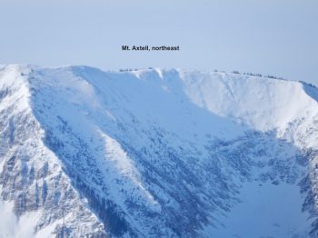
Mt. Axtell, note cross loading on the low ridges.

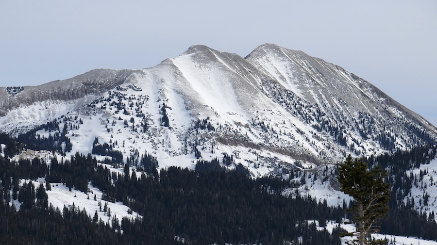
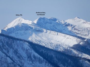
Upper anthracites w/ maximum loading on SE aspects.

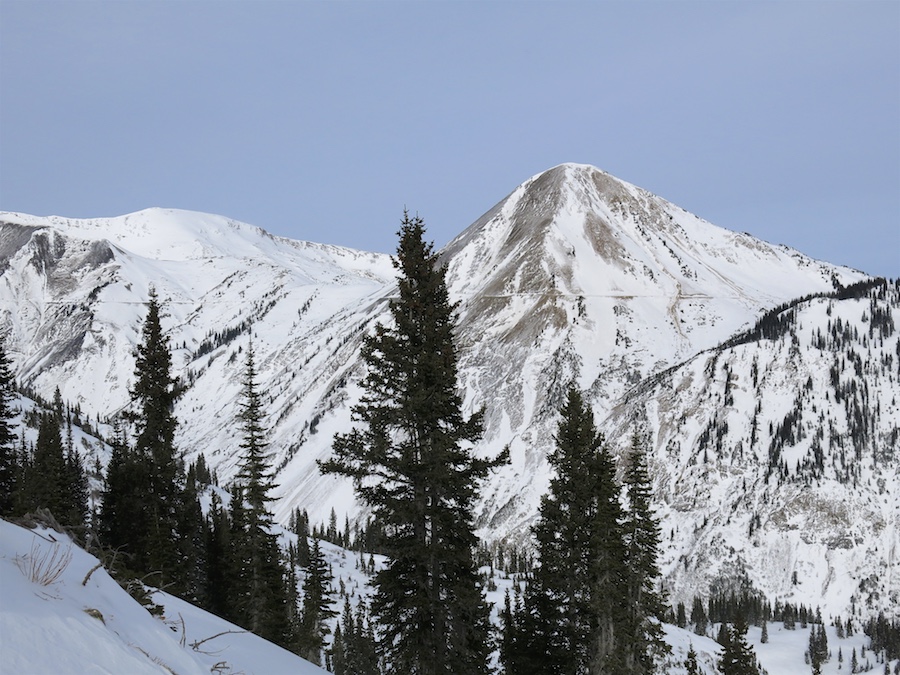
Mt. Emmons with a hint of cornice forming along the skier’s left ridge of Coon Basin.

Remarkably few avalanches observed through the southern end of the Ruby Range.

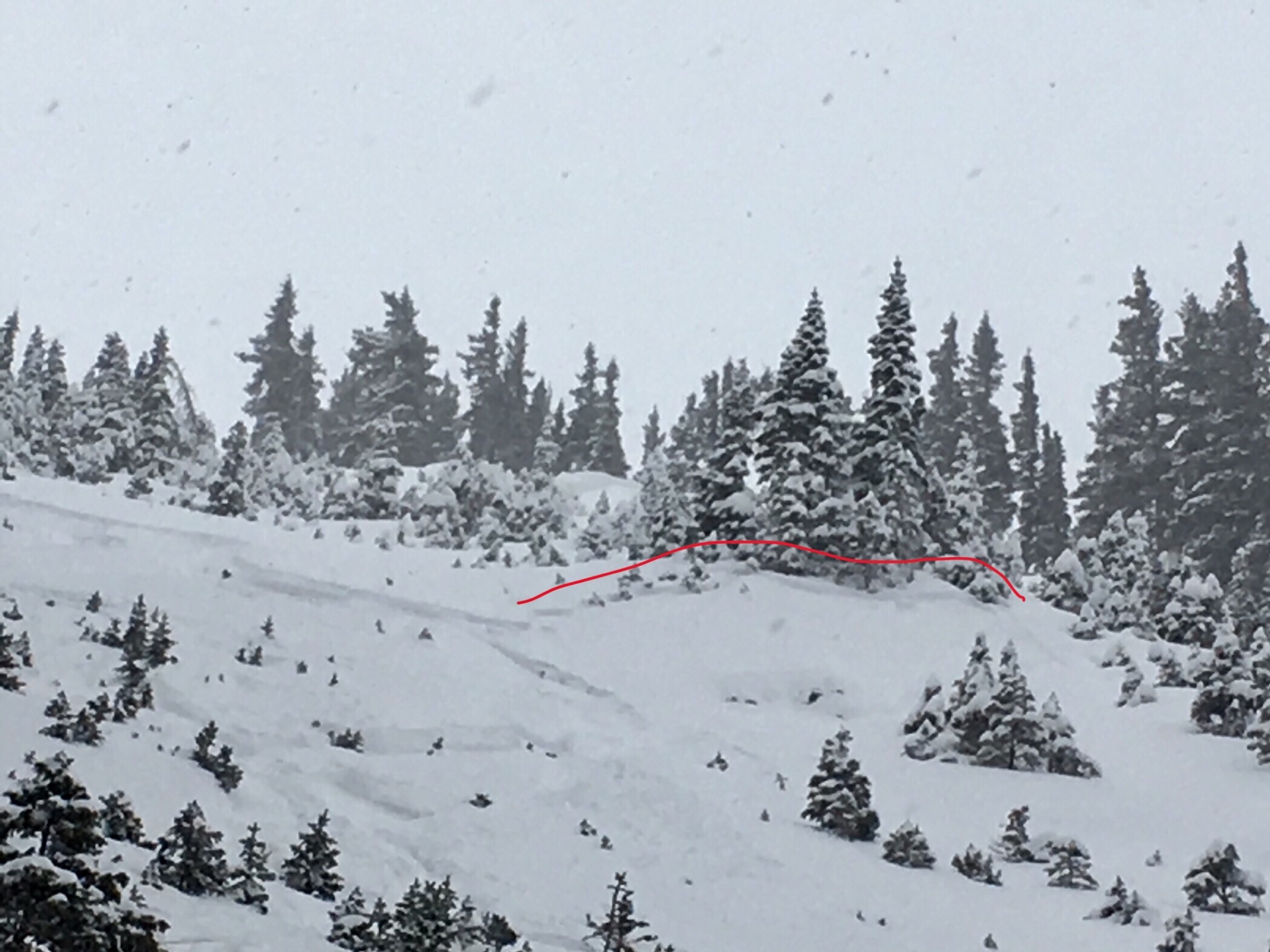
One small wind slab avalanche off Scarp Ridge.  SS-N-R1D1-U

Several small wind slab avalanches above Dipold Basin. SS-N-R1D1.5-U.

No avalanches visible of Gothic’s East Face.

Patrol knocked down a couple small one’s in Horseshoe…

and one at the top of Ruby Chief, both failing in the faceted layers below.

Meanwhile, on looking out towards Pearl Pass, the western aspects got hammered last night.

Mountain Weather December 24th, 2017

CB Avalanche CenterWeather

Date: 12/24/2017

Well, it sure is nice to be back in the flow after a very dry November and December. Today we’ll see a break in the weather before the next fast and turbulent storm rolls in tonight. While today is a break in the weather its still going to be blustery up there, with west winds in the 20+mph range at 11,000ft. Cloud cover will begin increasing tonight and snow showers will intensify around midnight. This incoming storm will be similar to Saturdays, but with a little less wind. I hope Santa has himself a nice full face helmet and face shield for his adventures tonight because it’s going to be a blustery ride. Westerly winds should ease slightly for Christmas day and snow showers will taper as the day progresses. Northwest flow will take us through next week with some moisture and clouds around, but nothing too notable until maybe later in the week around Thursday.

  • Today

    High Temperature: 22
    Winds/Direction: 20-25 G35/W
    Sky Cover: Increasing clouds
    Irwin Snow: 0
    Elkton Snow: 0
    Friend’s Hut Snow: 0

  • Tonight

    Low Temperature: 15
    Winds/Direction: 10 to 20/W
    Sky Cover: Overcast
    Irwin Snow: 5 to 7
    Elkton Snow: 6 to 8
    Friend’s Hut Snow: 4 to 6

  • Tomorrow

    High Temperature: 24
    Winds/Direction: 10 to 30/W
    Sky Cover: Overcast
    Irwin Snow: 2 to 4
    Elkton Snow: 2 to 4
    Friend’s Hut Snow: 2 to 4

Athracites

CB Avalanche Center2017-18 Observations

Location: Kebler Pass Area
Date of Observation: 12/23/2017
Name: Eric Murrow

Subject: Athracites
Aspect: North, North East
Elevation: 10,000 – 11,500

Avalanches:

We triggered several small, very soft slabs (3 x SS-AS-R1-D1) they ran more or less like loose sloughs. Propagation was only about 20 feet. I was not able to investigate crowns but they appeared to be around 6 inches deep, likely failing within the new snow (see photo). One other triggered slide (I couldn’t see crown) was believed to be closer to 12 inches deep as described by person that released it.

Weather: Overcast all day. Light snow most of the day, s-1. A short period, about 10am to noon, of s1,s2 snowfall rates. Winds were light for most of the day with very little transport. At around 330pm, the winds noticeably ramped up to 20+mph. Winds out of NW. At 445pm winds were actively blowing snow out of seven bowl and into upper parts of east bowl. Snowmos accumulated 3.5” of snow from 10:15 to 4:45.
Snowpack: New snow accumulations since Wednesday night were between 8 and 12 inches. New snow had yet to form a slab. Did notice a slight storm density change about 5 inches down.

Photos:

Valley bottom ob.

CB Avalanche Center2017-18 Observations

Location: Crested Butte Area. Washington Cultch
Date of Observation: 12/23/2017
Name: Evan Ross

Subject: Valley bottom ob.
Aspect: East
Elevation: 9,600-10,000

Weather: Obscured Sky. Snowing mostly S1. About 2-3″ accumulation between 11am and 3pm. Some gusty down valley winds but we were mostly protected by some trees.
Snowpack: Was only on sub 30 degree low angle terrain in the valley bottom. About 6″ of new snow accumulation since Thursday. Hand pits showed the top couple inches of new snow moving onto of Thursdays snow and not on the old snow/faceted interface.. Though these obs were from so low in the valley and there really wasn’t any slab yet for notable results. HS about 40cm.

Photos: