Cascade

CB Avalanche Center2017-18 Observations

Location: Kebler Pass Area
Date of Observation: 01/23/2018
Name: Ben Pritchett

Subject: Cascade
Aspect: East, South East, South
Elevation: 9,600′-11,400′

Avalanches:

One SS-N-R1-D1-O on a steep southeast bulge.

Weather: Cool clear day. Light Northwest winds produced light blowing snow above 12,000′.
Snowpack: Snow surfaces stayed dry on all but the sunniest steep solar collector type features. Creamy settled snow surfaces where the 1/20 snow remained in place. The wind had scoured some slopes back to the mid January sun crusts, but for the most part, surfaces remained soft.
Dug in an alpine’ish 11,000′ site on a steep due South aspect with an HS of 90 and found a very strong snowpack, with old percolation tubes between each of the 3 prominent buried crusts. The faceted “weak layers” between the crusts were at least 1-finger hard and sintering. This snowpack would hold a great deal of water before failing on due South.
However, transition just a little around the corner to southeast and the picture is less rosy. Southeast held much thinner crusts with weaker 4-finger facets between. This snowpack could fail at the 1/20 interface or even near the ground with 1-2″ of water respectively. It will be worth keeping in mind these crust face sandwiches on the southeast aspects when more snow arrives.
At the moment, there was no avalanche problem observed on these aspects. The wind lips (mini cornices) formed this past weekend were unreactive, with a strong bond at the 1/20 interface.

Photos:

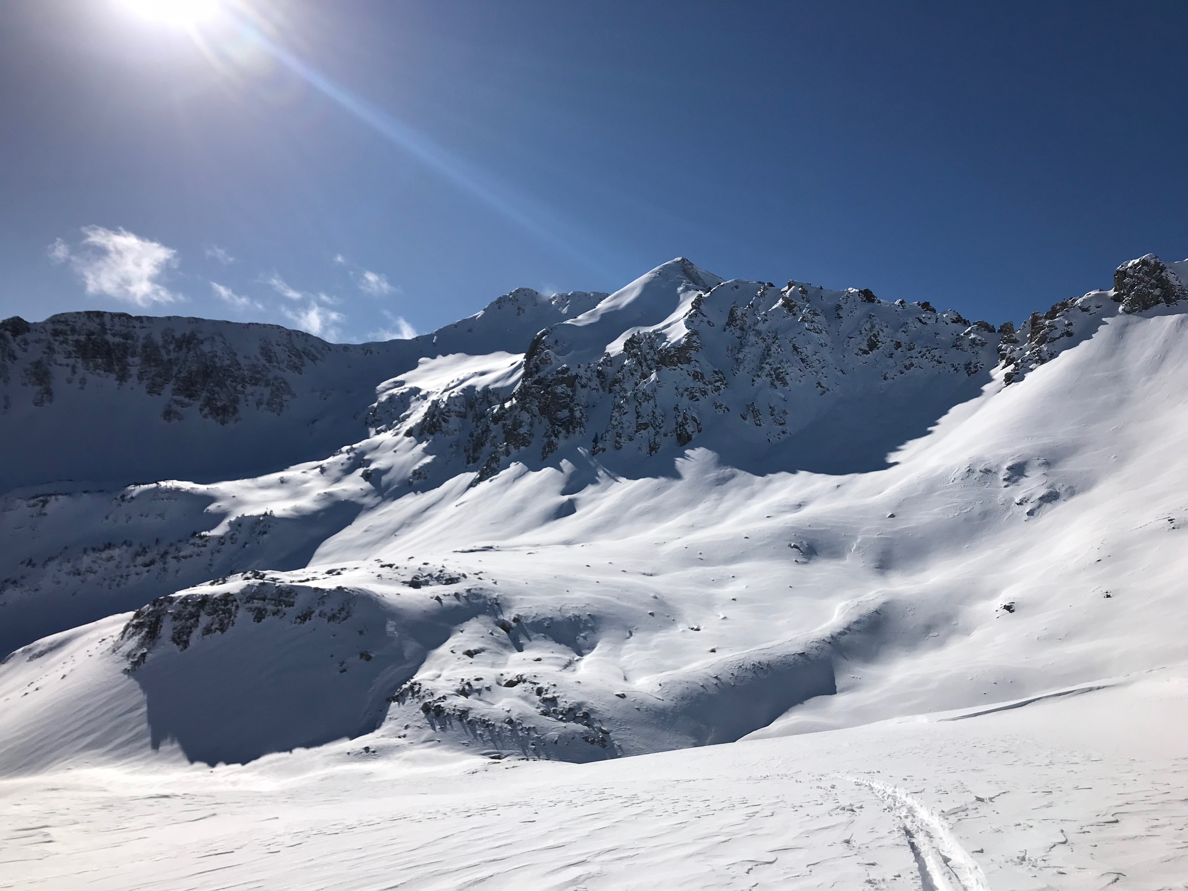
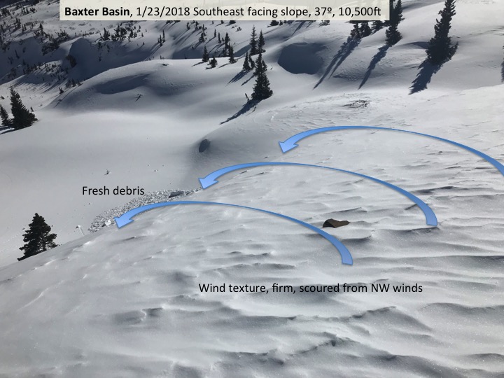
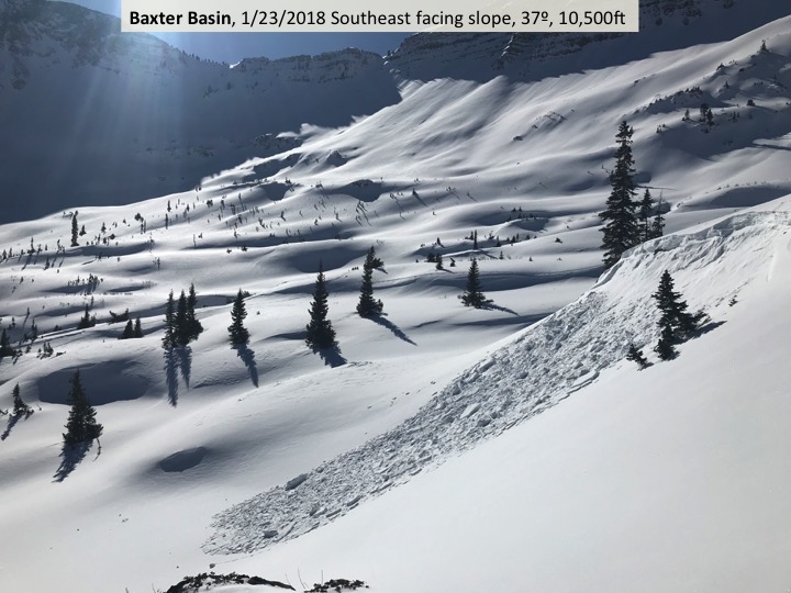
Baxter Basin w/ plenty of evidence of recent drifting

Profile on a South aspect, 11,000′, strong snowpack at this site, but much weaker as you transition to Southeast.

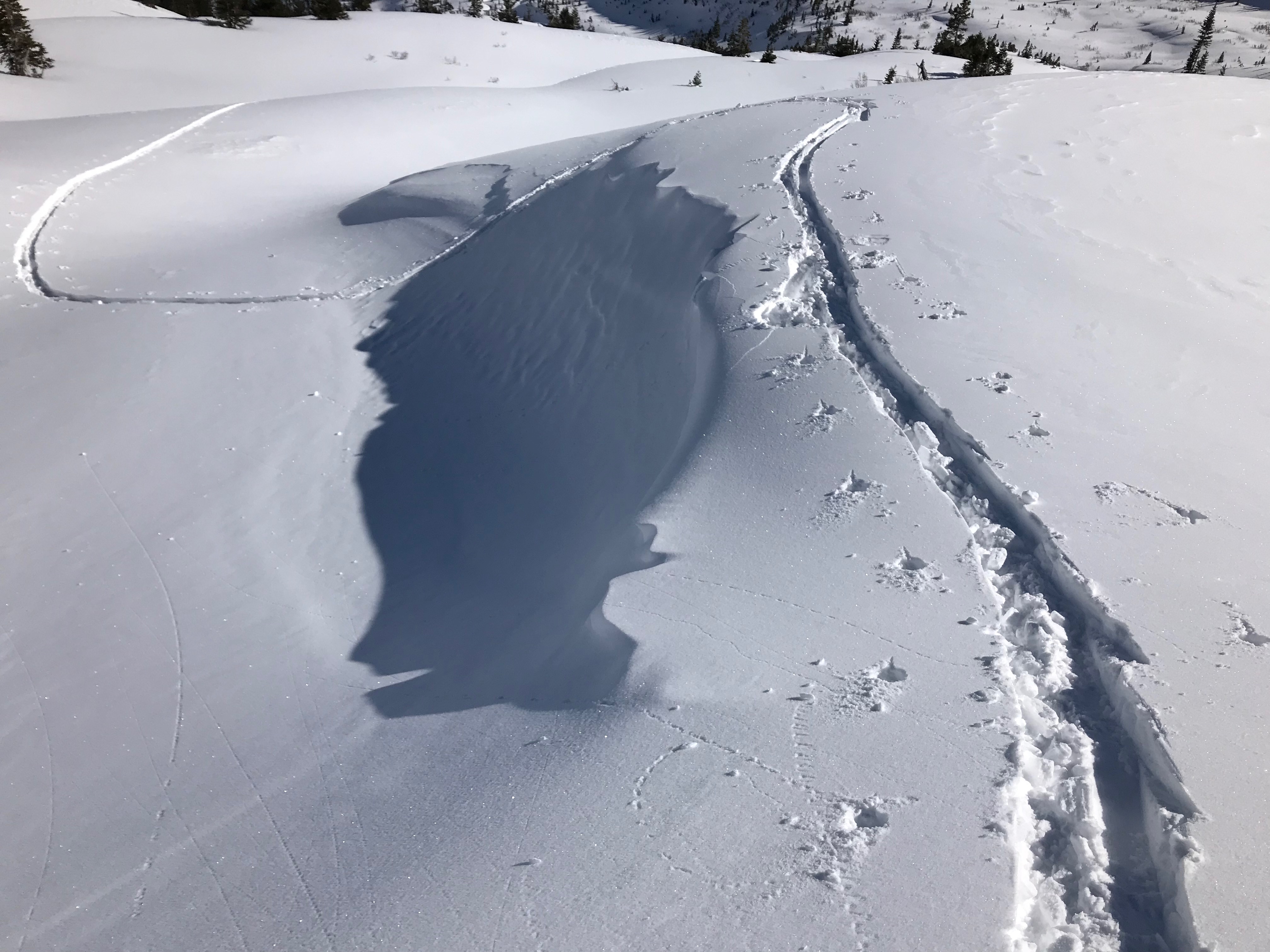
only minor cracking and no collapsing showing good bonds at the 1/20 interface

~3 day old wind slab avalanche

Baxter/Cascade

CB Avalanche Center2017-18 Observations

Location: Paradise Divide Area
Date of Observation: 01/23/2018
Name: Ian Havlick

Subject: Baxter/Cascade
Aspect: East, South East, South, South West, West
Elevation: 9600-11700

Avalanches:

Observed a handful of suspiciously fresh avalanches, primarily on east facing, near and above treeline terrain, looked 10-20″ deep on steep slopes. One slide in particular looked very fresh near “Birthday bowl” (i believe) on Schuykill ridge–very popular run. Didnt see it on the way in, noticed late in day on return, no binoculars, so hard to verify age. D2 in size.

Weather: Mostly clear, a few wisps of clouds in the afternoon hanging around high peaks. Temperatures stayed chilly, even in afternoon. Highs in high teens, low 20s. Light breeze from WNW.

Snowpack: Snowpack traveled today was mix of setting powder from last storm, sastrugi, and stiff, dense wind stiffened snow from last 2 days of W-NW winds. Focused observations on southerly half of compass near and above treeline. Somewhat concerning snowpack structure with 2 significant layers to watch. One being the ~Jan 20th meltfreeze crust (and 1mm facets) which was buried by our last storm and windloading, and the second being the buried 2-3mm facets near the ground, both found consistently across southerly terrain. PST30/100end on 12/23 solstice facets on 38º, SE facing roll near treeline. ECTV on same layer, failing on isolation, 10cm off ground. Most suspect slopes on southern half of compass seem to be those steep, 35º+ slopes, which have seen significant (2ft+) windloading over the last few days, straining persistent weak layers. Observed one naturally failing steep drift on ascent.

Photos:

Mountain Weather January 23, 2018

CB Avalanche CenterWeather

Date: 01/23/2018

You can always tell when high pressure regains its influence over the Gunnison Valley as the inversions re-establish. This morning we saw -16 here in town, and 5 degrees up at CBMR. For the next few days, expect gentle westerly flow to bring clear skies and a day over day warming trend Tuesday, Wednesday, and Thursday.

  • Today

    High Temperature: 20
    Winds/Direction: 10 to 20, Northwest
    Sky Cover: Clear
    Irwin Snow: 0
    Elkton Snow: 0
    Friend’s Hut Snow: 0

  • Tonight

    Low Temperature: 10, colder in the valley floor
    Winds/Direction: 5 to 15, Northwest
    Sky Cover: Clear
    Irwin Snow: 0
    Elkton Snow: 0
    Friend’s Hut Snow: 0

  • Tomorrow

    High Temperature: 28
    Winds/Direction: 10 to 20, West
    Sky Cover: Clear
    Irwin Snow: 0
    Elkton Snow: 0
    Friend’s Hut Snow: 0

Snow Safety team report

CB Avalanche Center2017-18 Observations

Location: Kebler Pass Area
Date of Observation: 01/22/2018
Name: Irwin Cat Operation

Subject: Snow Safety team report
Avalanches: None aside from small windslab, SS-AE-R1-D0.5-I. (50cm x 100m x 40m) Peeled into the cornice and only ran 100′. Blocks and
debris nice and spread out on the slope

Weather: Clear, NW winds lightly transporting snow. Relatively cold with strong solar.
Snowpack: 20-30 cm’s of new snow only showing signs of cohesion or windslabs just below ridge
top. Aggressive ski cuts did not produce any results, mix of scoured and small pillowed windslabs behind trees, rocks, etc. Pasted with minimal ski pen 15cm’s. Evidence of wind effect down below treeline in open areas. New snow seems well bonded to 1/21 interface on SE (Sonic) with multiple hand shears pulling the top of the storm snow of but not at the interface.

Mountain Weather

CB Avalanche CenterWeather

Date: 01/22/2018

A proper cold storm, wind, and enough snow to keep from feeling let down. We will take it! Temperatures this morning are frigid and those biting winds will be subsiding slowly throughout the day. Clouds will linger across the higher elevations and eventually clear as drier air moves into our area. We will feel a slow rebound in high temperatures each day this week, with sunny skies and dry air dominating. Our next shot of snow looks like Thursday night into Friday. Still a ways out, so strength of this storm is uncertain.

  • Today

    High Temperature: 20
    Winds/Direction: 10-20/NW
    Sky Cover: Partly Cloudy
    Irwin Snow: 0
    Elkton Snow: 0
    Friend’s Hut Snow: 0

  • Tonight

    Low Temperature: -6
    Winds/Direction: 5-15/NW
    Sky Cover: Partly Cloudy
    Irwin Snow: 0
    Elkton Snow: 0
    Friend’s Hut Snow: 0

  • Tomorrow

    High Temperature: 25
    Winds/Direction: 5-15/NW
    Sky Cover: Partly Cloudy
    Irwin Snow: 0
    Elkton Snow: 0
    Friend’s Hut Snow: 0

Blustery, windy, snowy, coldy

CB Avalanche Center2017-18 Observations

Location: Kebler Pass Area
Date of Observation: 01/21/2018
Name: Evan Ross

Subject: Blustery, windy, snowy, coldy
Aspect: North, South
Elevation: 10,000-11,500

Avalanches:
Weather: Cold, windy, snowing, you get the point. Winds were moderate with stronger gusts in the Kebler corridor. Elevation didn’t really change the wind speeds, the wind speeds changes were more due to the openness of the terrain. At ridgeline winds were more north then northwest. HST was about 20-25cm at 11,000ft by 2:30pm. Less then reported elsewhere in the area. Probably do to windy weather.
Snowpack: Lots of snow drifting onto the Southern half of the compass in the Anthracites. Though this snow wasn’t failing on the 1/20 crust, nor was it enough load to collapse this crusts. This was one south facing slope at rideline in the Anthracites, higher in elevation or different terrain characteristics could certainly change things.

Got a couple laps in on some north facing slopes with no persistent slab issues or obvious signs to instability. Small, cross loaded windslabs were about it. Though these northerly observation are poor quality given the number of previous skier traffic in the terrain.

Small sluffing was the most widespread issue observed today.

Photos:

Anthracite Mesa N-NE

CB Avalanche Center2017-18 Observations

Location: Crested Butte Area
Date of Observation: 01/21/2018
Name: CB AIARE L2

Subject: Anthracite Mesa N-NE
Aspect: North, North East
Elevation: 9458′ – 10,800′

Avalanches:

Remnants of old avalanche on NE aspect near Avy one glades touring into Coneys’.

Weather: Group 1) 12:47 OVC skies, -11c Air, 10171′, Precip: S1, NNW Light-Moderate w/ Strong gusts occasionally,
Group 2)12:30 OVC skies, -5c Air, 10100′, Precip: S1, Moderate Winds
Snowpack: Group 1)10200′
HS: 100cm
HN:24cm
PWL @ 65 cm from surface on 2-3mm Depth Hoar: CT20 SC, CT15 SC, ECTP19 SC
Hardness of slab above PWL: F(srfc) – 1F
Below PWL: F to ground
Footpen: 50cm
Group 2) 10100′
HS: 95
HN: 24cm
PWL @ 80cm from surface on FC 1-2mm: PST 60/100 END
Hardness of slab above PWL: F(srfc)-1F
Below Pwl: 4F-P

Photos:

Gothic 5:30am

CB Avalanche Center2017-18 Observations

Location: Crested Butte Area
Date of Observation: 01/21/2018
Name: billy barr

Subject: Gothic 5:30am
Aspect:
Elevation:

Avalanches:
Weather: Snow starting around 9 p.m. going off and on overnight though not much the past few hours and only 2½” so far with 0.19″ water and snowpack at 27″. It was partly cloudy when i went out around 5:20 and cloudy and snowing again (very lightly) when i was done about 20 minutes later. Currently snowing lightly while mostly cloudy and generally calm though with occasional gusting to 8 from the west. Temp. dipped to 10 with the clearing but now at 15F. Will update if needed at the 7 a.m. sweep time.
Snowpack:

Photos:

Old Bed Surfaces

CB Avalanche Center2017-18 Observations

Location: Paradise Divide Area
Date of Observation: 01/20/2018
Name: Evan Ross

Subject: Old Bed Surfaces
Aspect: North East
Elevation: 9,000 to 11,000

Avalanches:
Weather:
Snowpack: The wide propagating avalanches from our last avalanche cycle sure are cool to lay eyes on. The crush and flush analogy didn’t appear to work on the avalanche paths I viewed on Schuylkill Ridge. HS is shallow below these old crowns. With a couple inches of NSF on top of the old bed surface and still 10 to 30cm’s of large grained depth hoar below. These slopes lost their mid-pack, butt didn’t loose their persistent weak layers.

Photos:

Mountain Weather January 21, 2018

CB Avalanche CenterWeather

Date: 01/21/2018

The current low-pressure storm impacting the area remains interesting to watch in how it’s going to pan out, as confidence isn’t high on which way it’s going to go. The low pressure is moving right through central Colorado today. This makes the wind forecast a bit more difficult, and how much those wind directions are going to contribute local orographic lift. Will the right wind directions set up before the atmosphere starts drying out behind this low-pressure system? We will see. A cold front moving in with this system will help keep the precipitation intensity up this morning at least, and will keep the high temperature from creeping up much today. We’ll see clouds breaking up tonight and into tomorrow before a little blip in the weather Monday night with increasing clouds and maybe a flurry. By Tuesday we’ll be back in a high-pressure ridge taking us into the rest of the week.

  • Today

    High Temperature: 15
    Winds/Direction: 10 to 20/NNW
    Sky Cover: Overcast
    Irwin Snow: 6 to 9
    Elkton Snow: 5 to 8
    Friend’s Hut Snow: 3 to 5

  • Tonight

    Low Temperature: 0
    Winds/Direction: 10 to 21/NW
    Sky Cover: Increasing clouds
    Irwin Snow: 0 to 1
    Elkton Snow: 0 to 1
    Friend’s Hut Snow: 0 to 1

  • Tomorrow

    High Temperature: 20
    Winds/Direction: 5 to 15/NW
    Sky Cover: Partly Cloudy
    Irwin Snow: 0
    Elkton Snow: 0
    Friend’s Hut Snow: 0