Location: Paradise Divide Area
Date of Observation: 04/06/2018
Name: Evan Ross
Subject: My underwear got wet
Aspect: North, East, South
Elevation: 9,000-11,000
Avalanches:
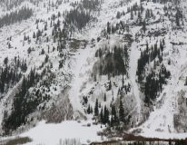
Most of the loose wet avalanches observed were in the D1 to D1.5 range on East to North facing aspects. Observed a few D1 wet loose avalanches on southerly facing terrain. New wet loose avalanches in Climax Chutes, Schuylkill Ridge, Purple Ridge, and Cascade Mountain. The highest elevation wet loose avalanche activity was off of Cascade Mountain at 11,700ft on its northeasterly face.
Weather: Got out in the late afternoon. The mid-day break in the storm got going again in the afternoon. Rain like substance falling from the sky at the Slate River TH transitioning to snow out by Pittsburg. Overcast sky and just enough wind to blow some snow around at ridgeline.
Snowpack: So wet below 10,500ft. New snow accumulations in Pittsburg were about 3″ wet inches of snow. Climbing towards 11,000ft at the head of Washington Gulch that new snow started drying out and was about 7 moist inches at 4pm. The top inch was dry and cold. Also measured 7″ wet inches of snow in Poverty Gulch at 9,600ft. The new snow is sitting on a wet saturated snowpack at lower elevations, and was sitting on a wet and soft crust on an easterly facing slope at 11,000ft. Lots of wet loose avalanches at lower elevations, but minimal signs to instability at elevations near 11,000ft.
-
-
New wet debris below the Climax Chutes
-

-
Small wet snow avalanches in Happy Chutes below treeline.
-

-
-
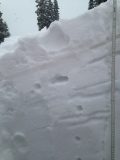
Low angle easterly aspect at 11,000ft. About 7″ of moist snow sitting on a wet and soft permeable crust.


