Shallow Storm Slabs

CB Avalanche Center2018-19 Observations

Location: Kebler Pass Area
Date of Observation: 01/16/2019
Name: Evan Ross, Eric Murrow, Zach Kinler

Subject: Shallow Storm Slabs
Aspect: East, South East, South
Elevation: 9,500-11,600

Avalanches:

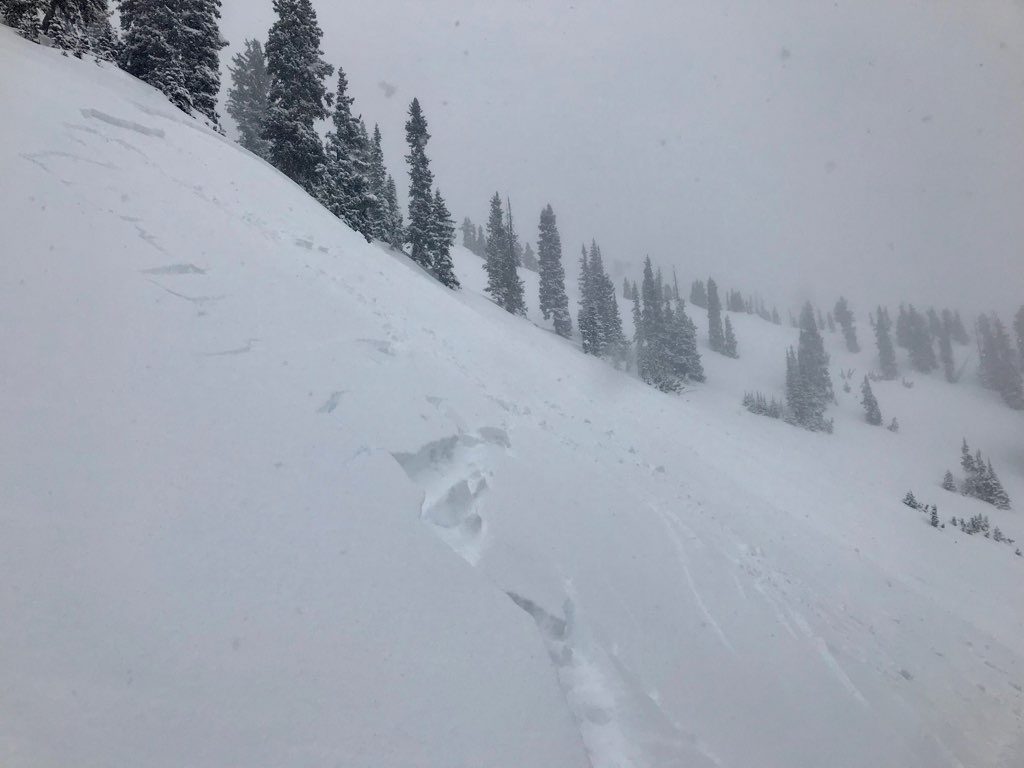
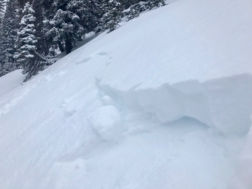
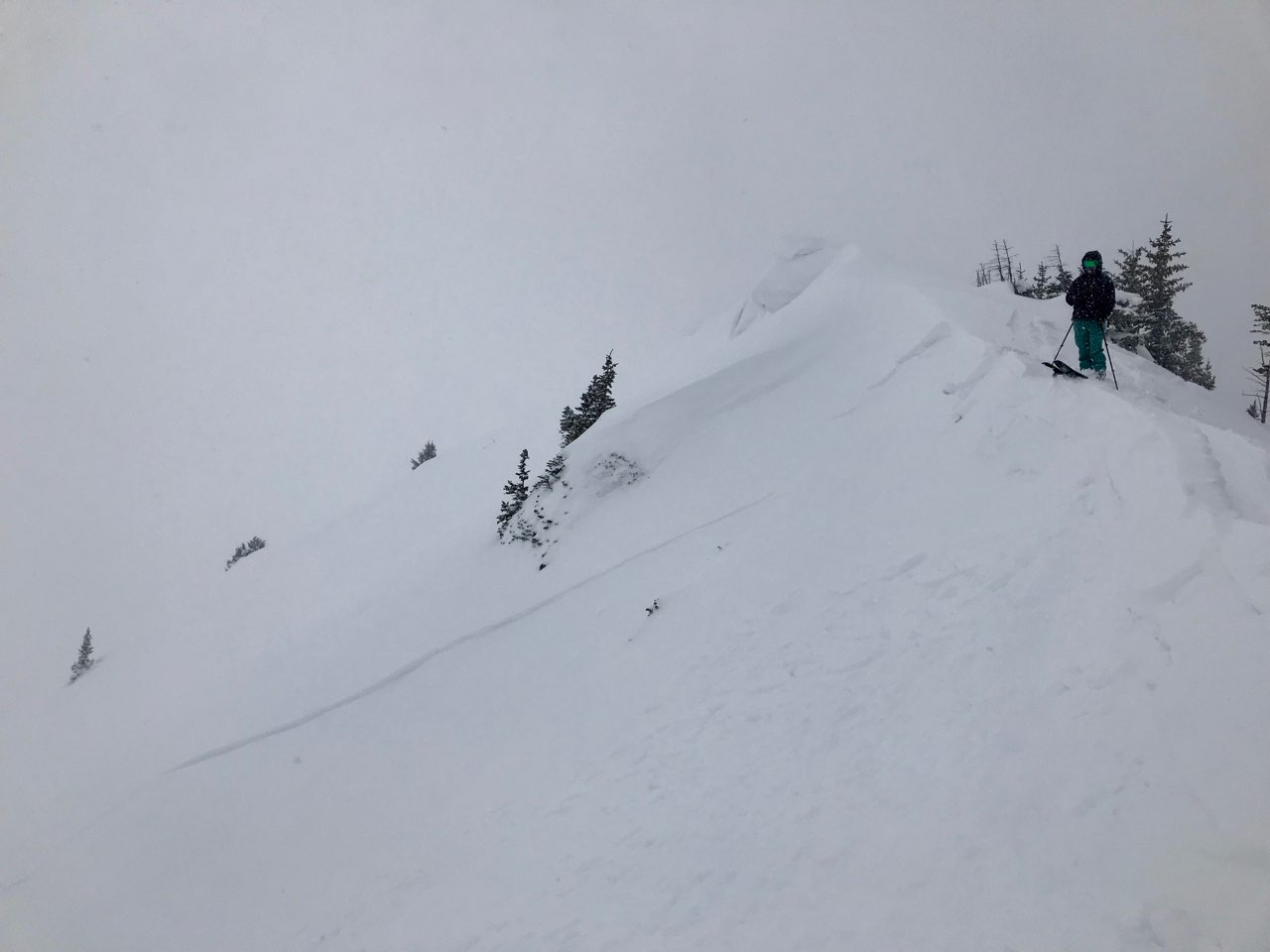
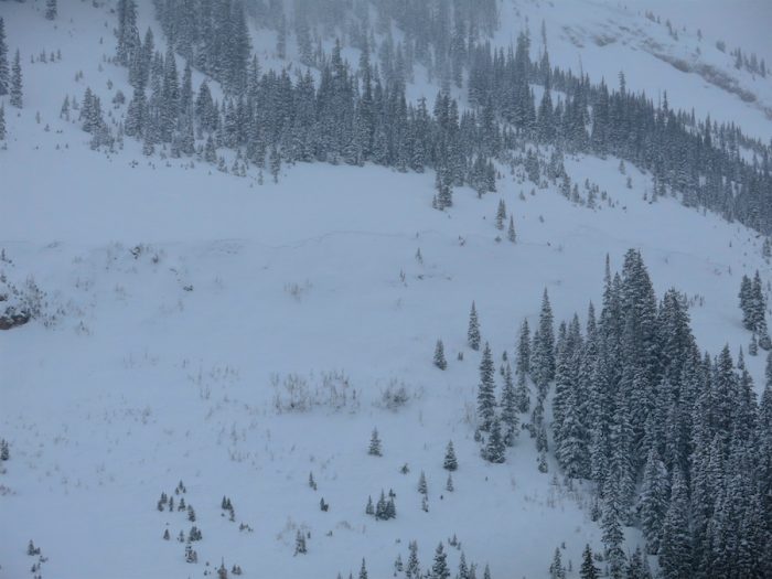
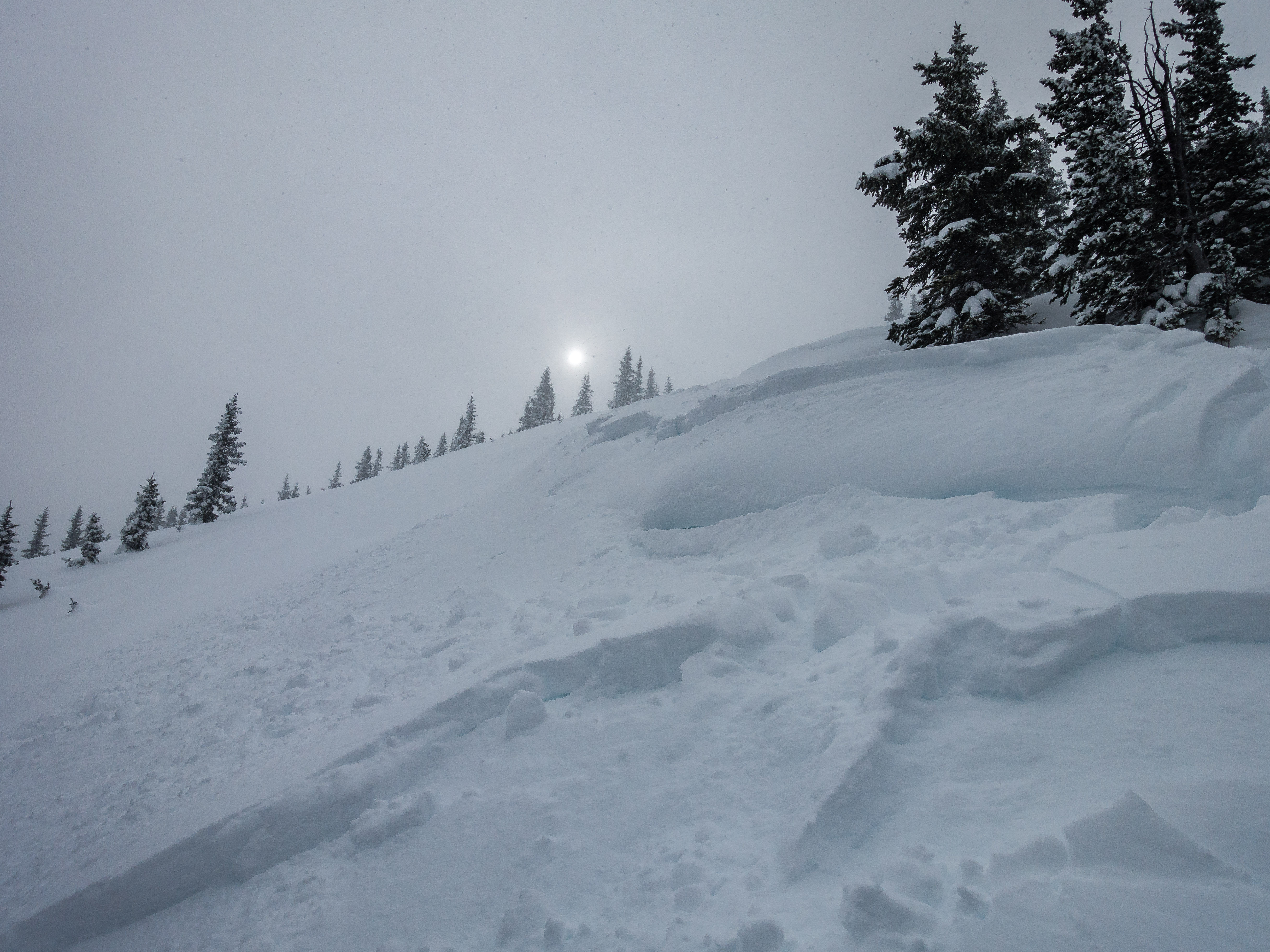
Several very wide propagating storm slabs were observed. A couple of these crown widths were estimated in the thousand or couple thousands of feet wide. While wide, these slabs were not very deep and only amounted to D1’s and D1.5’s. These natural avalanches were observed on South, East and West slopes.


Weather: Cloudy skies with light and variable winds in sheltered terrain and moderate SW winds in exposed areas and ridge lines. Temps in mid 20s. S-1 to S1 snowfall throughout day with 2-3” accumulations on tour.

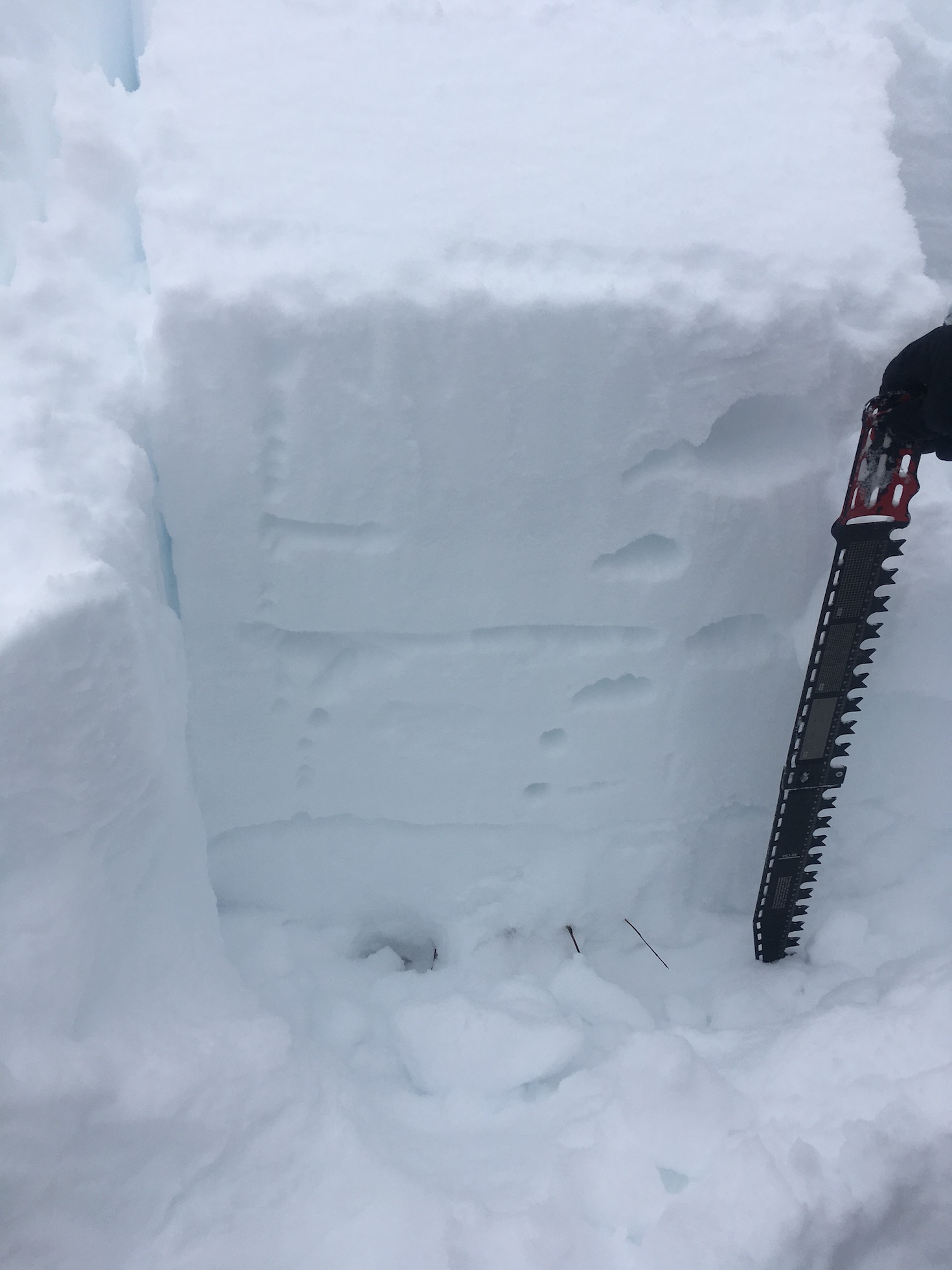
Snowpack: At 9,500ft we measured 7″ of new snow at about 11am, and 9″ of new snow at about 3pm. Higher in the terrain, the 9″ felt about average for the day ending by 3pm. A shallow storm instability was the only avalanche concern observed. The storm slabs were failing just above the interface in the storm snow. Small amounts of wind-loading was confined to right at ridgeline in this area and did not extend far down slope. HS was around 120 on southerly slopes and increasing to about 150 on the more easterly tilted and cross-loaded slopes

Photos:


anthracites storm instabilities

CB Avalanche Center2018-19 Observations

Location: Kebler Pass Area
Date of Observation: 01/16/2019
Name: MR

Subject: anthracites storm instabilities
Aspect: North
Elevation: 10,000-11,500

Avalanches:

storm slab instabilities – cracking and stuffing – on any and all terrain over 35 degrees or so. One wind roll at the top of big chute had already released and we easily got the other to pop rolling up to it. Minimal propagation or entraining, but we didn’t see or ski any bigger terrain.

Weather: storm day! From 8am-1pm – snow varying from s1-s3, stronger toward end of day, winds picking up throughout the day. Warm and wet

Snowpack: 4 inches new snow at base of anthracites at 8 am, 6-8 inches up high at 9 am. Dense snow. By the time we got back to the sleds at 1 there was an additional 4-5 inches.

Photos:

Anthracite Mesa-Coneys-AM Tour

CB Avalanche Center2018-19 Observations

Location: Crested Butte Area
Date of Observation: 01/16/2019
Name: ADB

Subject: Anthracite Mesa-Coneys-AM Tour
Aspect: East
Elevation: BTL

Avalanches:

NA due to low visibility.

Weather: Obsucred skies; S2 snowfall primarily. Ridge tops winds were moderate while valley winds were light.

Snowpack: Between 4 and 7 inches had fallen within past 12 hours.
New skin tracks: a few collapses on 1F snow about 7 inches below the surface (F and 4F snow on top of the 1F crust).
2 inch soft slabs were forming on the ridge top and the leeward side of the ridge.
After ski, observed 1 inch of new snow in the valley bottom skin track used by 4 tourers.

Gothic 7am Weather Update

CB Avalanche Center2018-19 Observations

Location: Paradise Divide Area
Date of Observation: 01/16/2019
Name: billy barr

Subject: Gothic 7am Weather Update

Weather: 7am report
Snow starting a couple hours after midnight moderate to heavy with 8″ new and water a light 0.48″ as snow pack reaches winters deepest of 43½”. Currently obscured cloud cover with heavy snowfall and no wind (hooray for that one) and 22ºF.

Mountain Weather for 11,000ft

CB Avalanche CenterWeather

Date: 01/16/2019

Last night the first shortwave began to impact the area with 2.5″ at Irwin, nearly 3″ at CBMR, and Schofield Pass at an estimated 5″ as of 5:15 am. The low-pressure system is still well to the west and will bring a shift in flow direction from SW to W during the day which will help to provide good orographic lift for the Crested Butte area especially from Kebler Pass to Schofield Pass. This system will likely drop another 8+ inches during the day with strong westerly winds blowing the new snow around. Thursday will dry out with little snow, but westerly winds will continue to blow in front of the second system in this back to back punch. Thursday night and Friday will bring another round of heavy snowfall with the potential for another foot according to current models.

  • Today

    High Temperature: 21 to 26
    Winds/Direction: 12 to 22 G30, W
    Sky Cover: Overcast
    Irwin Snow: 6 to 10″
    Elkton Snow: 6 to 10″
    Friend’s Hut Snow: 5 to 9″

  • Tonight

    Low Temperature: 11 to 16
    Winds/Direction: 10 to 20, W
    Sky Cover: Overcast
    Irwin Snow: 1 to 3″
    Elkton Snow: 1 to 3″
    Friend’s Hut Snow: 0 to 2″

  • Tomorrow

    High Temperature: 10 to 15
    Winds/Direction: 13 to 23, WSW
    Sky Cover: Mostly Cloudy
    Irwin Snow: 0 to 1″
    Elkton Snow: 0 to 1″
    Friend’s Hut Snow: 0 to 1″

West of West out by Beckwith

CB Avalanche Center2018-19 Observations

Location: Kebler Pass Area
Date of Observation: 01/15/2019
Name: Eric Murrow

Subject: West of West out by Beckwith
Aspect: North, North East, East, South East, South
Elevation: 9,300′ to 10, 700′

Avalanches:

one snowmobile triggered slide on small drifted SE slope BTL, D1. two other SE BTL naturals in the area on SE side of East Beckwith, D1. two natural D1.5 on steep east slopes BTL. One snowmobile ride out viewed one small D1 on north aspect of Mt. Axtel below cliff bands in 3rd bowl.

Weather: Partly cloudy skies to start turning mostly cloud skies with very light snow around 2pm.

Snowpack: This area several miles to the west of Kebler Pass on E and N aspects had average HS around 125cm, with one NNW location up to 145cm. Snow depths in this area were less than the Kebler Pass area and more than the far eastern areas like Brush or Cement Creek, closer match to the middle portion of the Gunnison zone like the lower Slate River corridor or Washington Gulch. Several test profiles were performed on SE, NE, and NNW locations. ECT scores showed hard or no result. Inspecting one suspected snowmobile triggered avalanche on a SE slope, the failure occurred on the Thanksgiving interface whereas the NE, and NNW slopes the Holiday interface or higher buried SH will be the interfaces of concern in near term with additional loading. Briefly poked into a very small chunk of a south slope and found HS between 70 and 90cm with stacks of facets and crust with crusts up to 3 cm.

Photos:

Surface obs

CB Avalanche Center2018-19 Observations

Location: Paradise Divide Area
Date of Observation: 01/15/2019
Name: Evan Ross

Subject: Surface obs Washington Gultch
Aspect: North East, East, West
Elevation: BTL

Weather: Sky became over cast by 10’ish am. Calm winds. Few flakes started falling at 2pm.

Snowpack: Interesting distribution of SH just below the snow surface. This SH was maybe .5cm down. Some places it was laid over, or poorly preserved, or just not there. In general, it didn’t look like it was going to be a well defined weak layer, but definitely something to keep a close eye on. On East and SE found the SH on top of a crust with a very light dusting of snow over it. These E and SE slope angels were around 30 degrees and I would wonder if it was more cooked off on steeper slopes.

Dug on pit on a ENE, 30 degree slope, at about 10,700ft. HS 120. No SH present on or just below the snow surface. Layer of SH down 20cm. No test results on the NSF below the holiday slab. Similar to this pit on Schuykill, those grains are now 1mm rounding and necking. Future layers of concern would be the upper SH layer, and the 4F depth hoard near the ground.

No collapses or shooting cracks.

Mountain Weather for 11,000ft

CB Avalanche CenterWeather

Date: 01/15/2019

Here we go, the next round of moisture is making its way towards Crested Butte! Today you can expect increasing cloud cover with the possibility of light snow for the favored areas to the west of town. Tuesday night and Wednesday will produce significant accumulations across much of the forecast area with the best snow, per usual, in areas from Kebler Pass to Schofield Pass. Thursday should have continued cloud cover with light snow before a second system impacts the area on Thursday night and Friday. Looks like we are in store for a few nice powder days!

  • Today

    High Temperature: 25 to 30
    Winds/Direction: 7 to 17, SW
    Sky Cover: Increasing clouds
    Irwin Snow: 0 to 2″
    Elkton Snow: 0 to 2″
    Friend’s Hut Snow: 0 to 2″

  • Tonight

    Low Temperature: 12 to 17
    Winds/Direction: 7 to 17, WSW
    Sky Cover: Overcast
    Irwin Snow: 5 to 8″
    Elkton Snow: 5 to 8″
    Friend’s Hut Snow: 3 to 6″

  • Tomorrow

    High Temperature: 25 to 30
    Winds/Direction: 10 to 20, W
    Sky Cover: Overcast
    Irwin Snow: 4 to 7″
    Elkton Snow: 4 to 7″
    Friend’s Hut Snow: 3 to 6″

Paradise South and West

CB Avalanche Center2018-19 Observations

Location: Paradise Divide Area
Date of Observation: 01/14/2019
Name: Eric Murrow

Subject:
Aspect: South, South West, West
Elevation: 10,700 – 12,000′

Avalanches: Viewed two unreported slabs from last weeks storm. One D2, East aspect, 10,200′ near Purple Palace. D2, West aspect 12,800 White Mountain

Weather: Beauty of a day.  Warm air temps near and above treeline with hardly a breath of wind.  Snow surfaces were moist midday on SE-S-SW near treeline and moist on south at 2pm at 12,000′

Snowpack: Travelled through some rolling benchy west facing slopes near treeline and dug test profile and confirmed structure through some other rolling terrain nearby.  This terrain sees less impact from the wind than most west slopes.  Not representative of west slopes in general but only “protected” west where snow is able to stay in place and not drift away.  See photo below

Did some probing into south facing ATL slope along the margins of a large bowl feature.  Areas I was able to poke at showed mostly facets and crusts, no real slab structure at the moment.  The crusts were generally 1 to 3cm thick and not a great structure for significant future loading.

Photos:

Phoenix/ Spellbound Bowl CBMR

CB Avalanche Center2018-19 Observations

Location: Crested Butte Area
Date of Observation: 01/14/2019
Name: CBPSP

Subject: Phoenix/ Spellbound Bowl CBMR
Aspect: North, North East
Elevation: 11,000′-10,000′

Avalanches:

AB-SS-R1-D1-O ( 4#AB)

Weather: Clear with strong solar radiation, winds were calm, and temperatures in the low teens throughout the day.

Snowpack: Observed N- NE aspects near and below tree line. In general a VERY WEAK SNOWPACK! Avg. HS 40-50 and up to 125 cm’s with ski pen to the ground. Soar legs with not much to talk about in terms of avalanche activity. Teams were able to trigger small loose dry avalanches in specific steep terrain with explosives. Also observed collapsing and cracking within specific terrain features. Teams also observed wide spread surface hoar through out the terrain. If the forecast produces we will have a problem on terrain at this aspect and elevation the current snow pack will not be able to support any significant load.

Photos: