Cement/Double Top Slides

CB Avalanche Center2018-19 Observations

Location: Cement Creek Area
Date of Observation: 01/24/2019
Name: Cosmo Langsfeld

Subject: Cement/Double Top Slides
Aspect: North East, West
Elevation: 9400-10600 ft

Avalanches:

Noticed these slides on my way back to the trailhead around 3pm. One small slide on E-NE facing slope on Doubletop. Not sure when this slid. Looked fairly fresh. Also two small slides low on Cement, West aspect,~9500ft. I think these slid sometime between 930am and 3pm on 1/24.

Weather: Snowing and low clouds early in the day. Clearing as the day went on. Wind blowing hard enough to transport snow in the valley bottom in the morning. Wind died down and it was calm by mid-morning. Very cold down low. Pleasant off the valley bottom.

Snowpack: Supportive. No obvious signs of instability on the way out. Dug down on low angled NE facing meadow BTL (~10600′). Snow depth 140cm. Top 30 unconsolidated. 110-95 Fist. Crusts at 95 and 85 cm above ground level with a distinct layer of sugar above the 85cm crust. Between the two crusts, 2 layers 1f-4f with softer snow between those two layers at 90cm above ground level. Below 85cm, snow was 4f to Fist, softening with depth until it turned to sugar somewhere around 35cm above ground level, grain size increasing with depth. Leaving the pit, when I got about 6 feet away, the snowpack settled audibly.
Photos:

Rough Overall Danger Analysis of CBAC Forecast Area

CB Avalanche Center2018-19 Observations

Location: Crested Butte Area
Date of Observation: 01/24/2019
Name: Ian Havlick

Subject: Rough Overall Danger Analysis of CBAC Forecast Area
Aspect:
Elevation:

Avalanches:

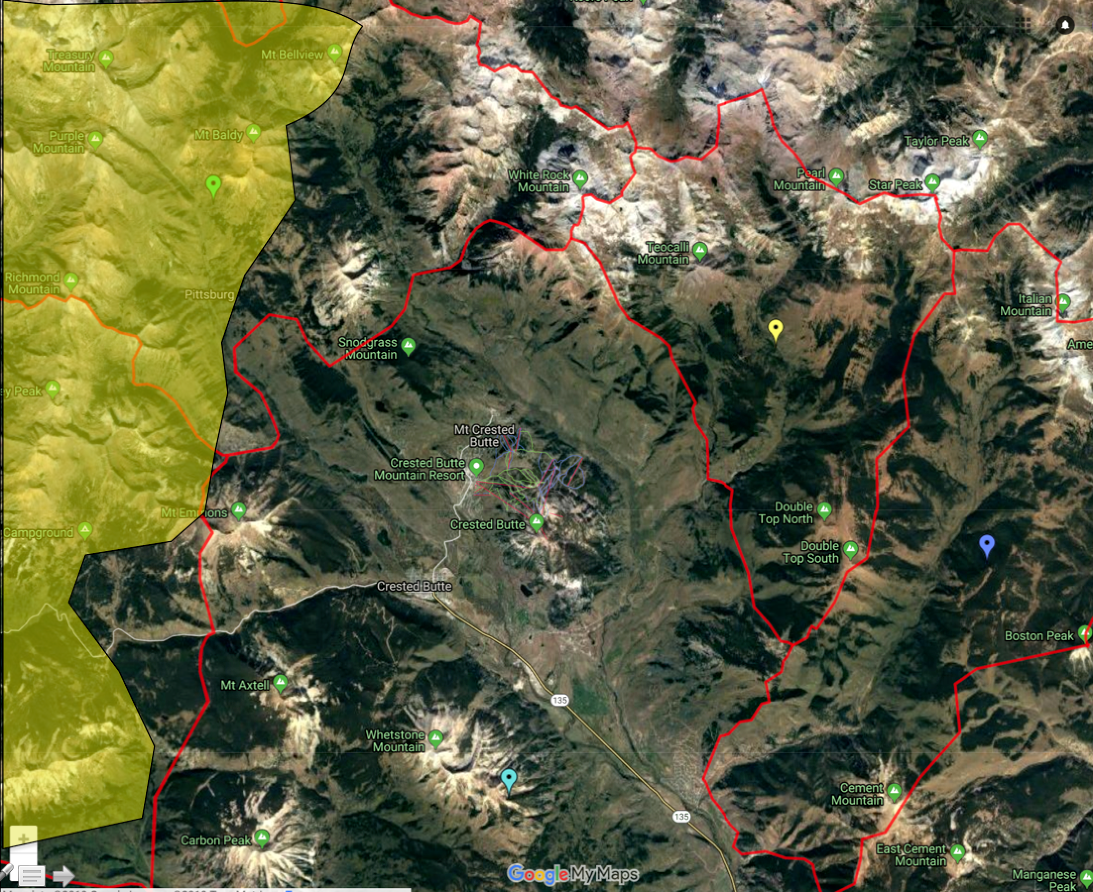
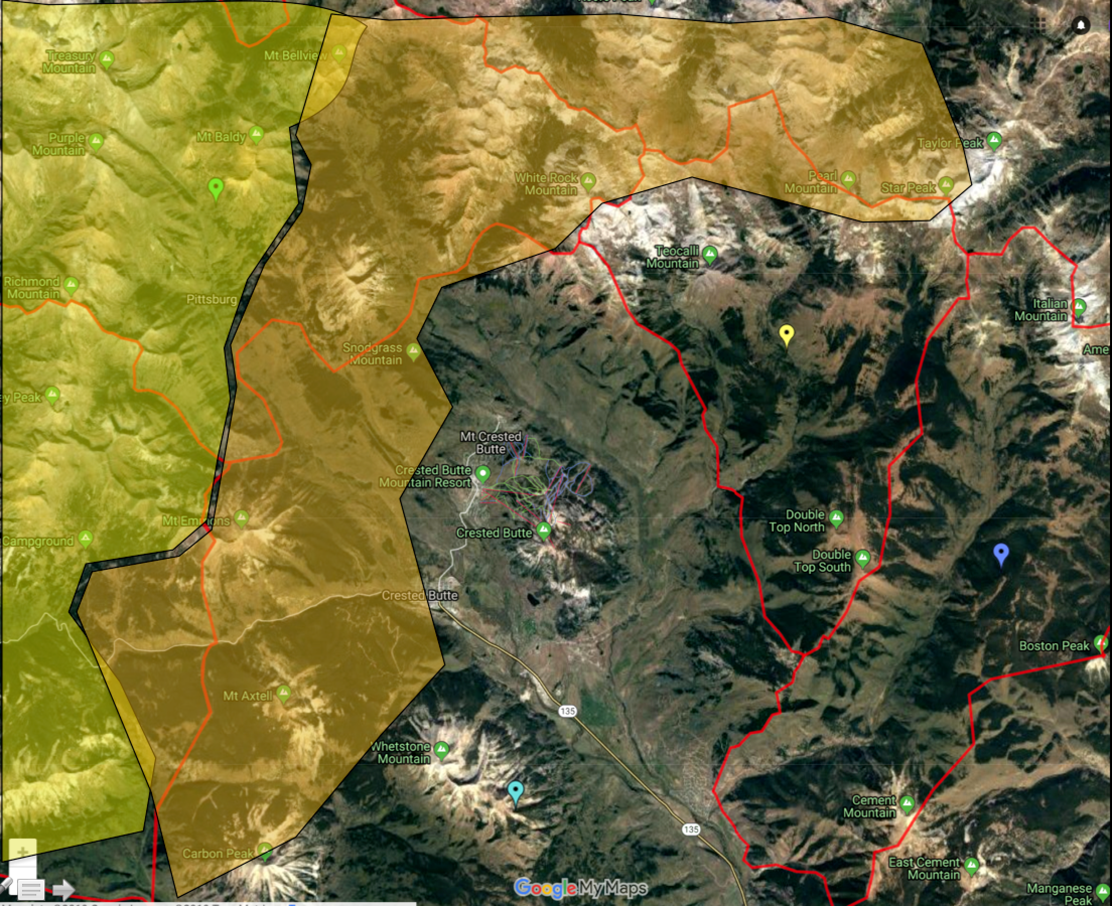
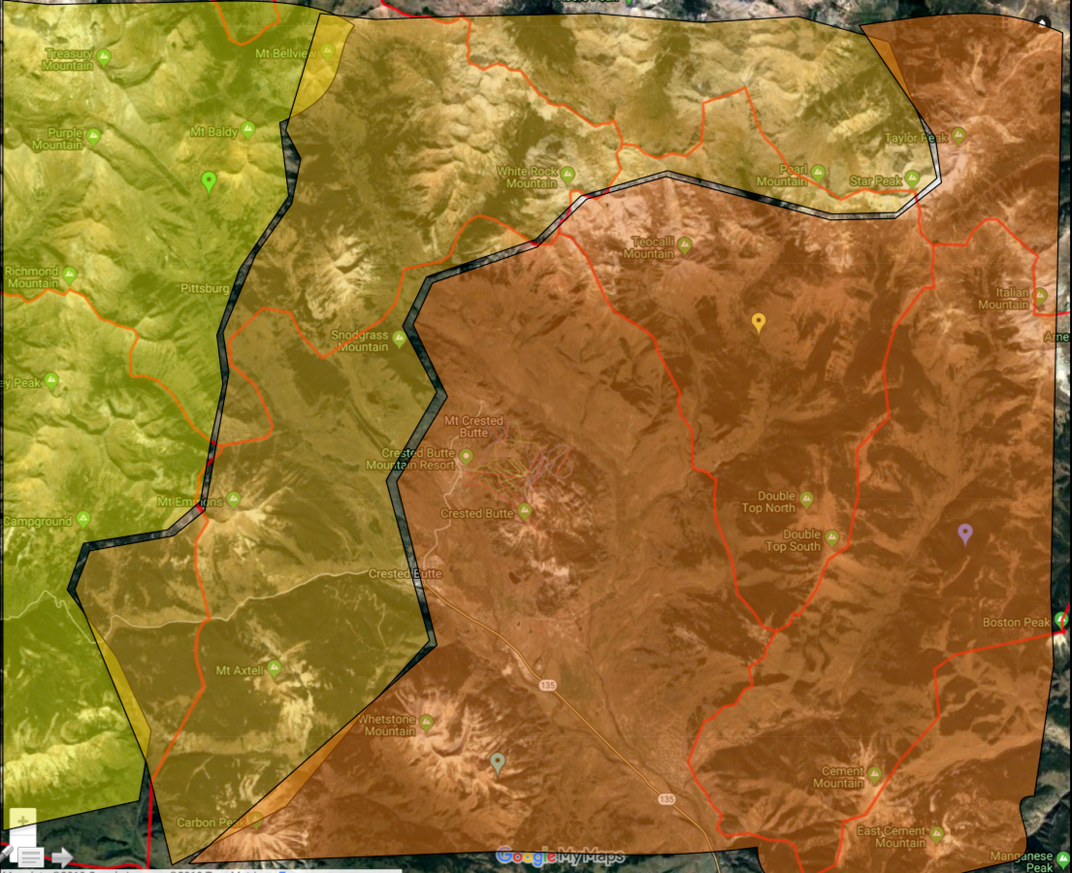
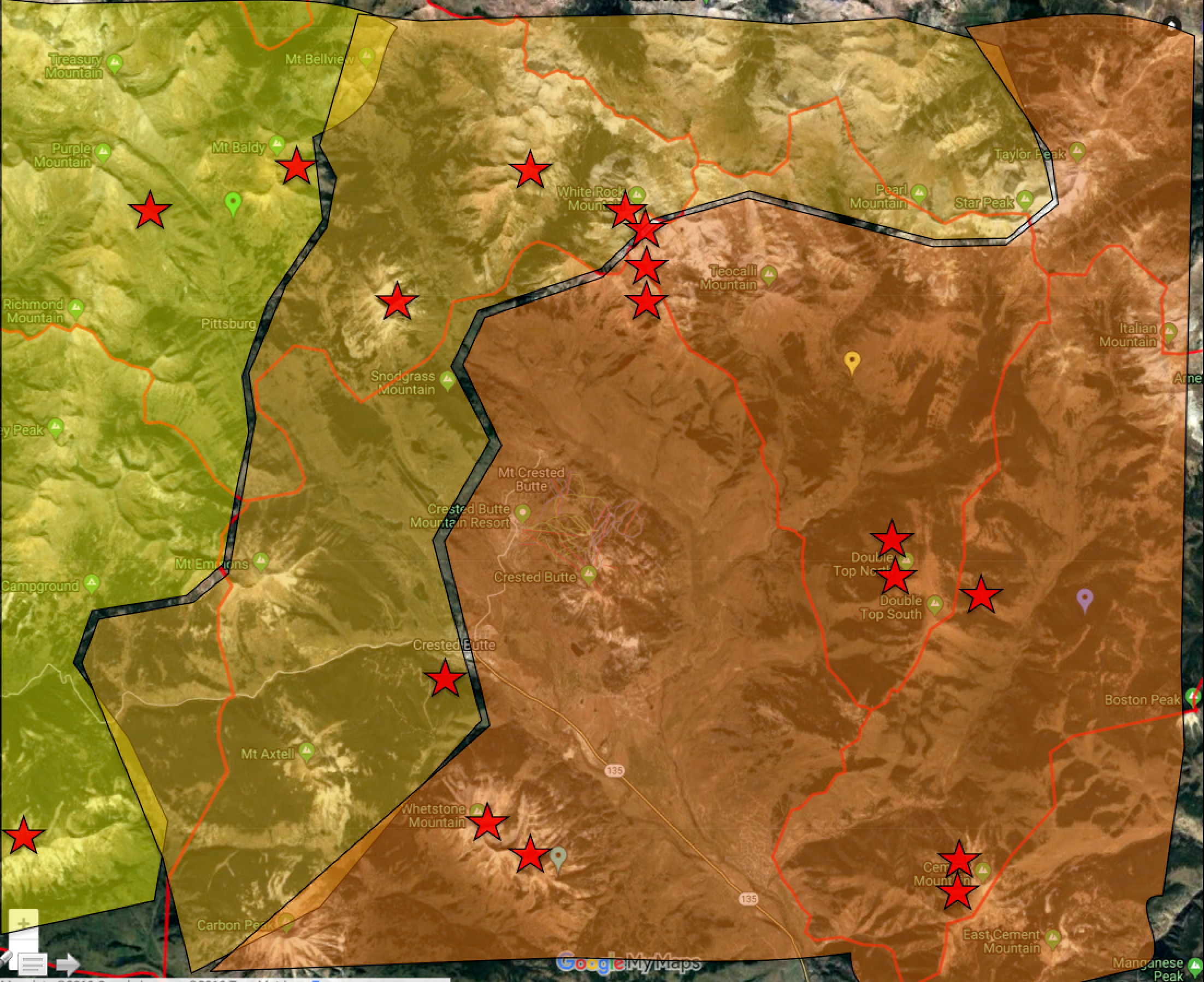
Rough Analysis of Avalanche danger across forecast area with colors corresponding (yellow=moderate danger, yellow-ish orange = trending from considerable to Moderate, and dark orange = lingering more widespread considerable danger). Additionally, red stars symbolize observed avalanches size D2.5 or larger since 1/18/2019.

As communicated in daily avalanche forecasts, the threat of greater (larger and more widespread) avalanche activity (both persistent slab and wind slabs) in the shallower snow-covered areas near and east of Crested Butte is symbolized in this visual interpretation.

As illustrated by the red stars, there have been many more large to very large avalanches in the eastern portion of our forecast area.  The greatest uncertainty lies in these transition areas in a band from Gothic, to Washington Gulch to Mount Emmons, to Mount Axtell.  

Two very large natural avalanches on the White Mountain massif

CB Avalanche Center2018-19 Observations

Location: Crested Butte Area
Date of Observation: 01/23/2019
Name: Avalanche

Subject: Two very large natural avalanches on the White Mountain massif

Avalanches: Two very large avalanche that ran early on 1/23. The sunny avalanche faces southwest, the shady one faces due west. These avalanches are located on the White Mountain massif to the north of Crested Butte.

Mountain Weather for 11,000ft

CB Avalanche CenterWeather

Date: 01/24/2019

The old “Clipper Storms”. That’s what it is going to be all about over the next few days. Small storms are dropping down the old Rocky Mountains on NW to SE flow and having various impacts to Colorado as they pass on by. Last nights clipper storm will start drying out early today. Looks like we should see clearing sky today, but moisture hangs out at lower elevations which makes me wonder if we’ll see some low valley clouds persist longer through the day. Orographics should keep snowfall and clouds around longer in the Paradise Divide and Irwin areas.

After a brief break today, we’ll see another small storm clip Colorado Thursday Night. Not much is expected out of this one. The next clipper rolls across Colorado Friday Night and this one looks better and should bring a few more inches of snow. Looks like drier weather for the weekend.

  • Today

    High Temperature: 17 to 22
    Winds/Direction: 12 to 22 NW
    Sky Cover: Partly Cloudy
    Irwin Snow: 1 to 3 AM
    Elkton Snow: 1 to 3 AM
    Friend’s Hut Snow: 1 to 3 AM

  • Tonight

    Low Temperature: 0 to 5
    Winds/Direction: 10 to 20 NW
    Sky Cover: Mostly Clear
    Irwin Snow: 1 to 2
    Elkton Snow: 1 to 2
    Friend’s Hut Snow: 1 to 2

  • Tomorrow

    High Temperature: 20 to 25
    Winds/Direction: 10 to 20 WNW
    Sky Cover: Mostly Cloudy
    Irwin Snow: 0 to 1
    Elkton Snow: 0 to 1
    Friend’s Hut Snow: 0 to 1

Snodgrass

CB Avalanche Center2018-19 Observations

Location: Crested Butte Area
Date of Observation: 01/23/2019
Name: Cosmo Langsfeld

Subject: Snodgrass
Aspect: North, East
Elevation: trailhead to 11000′

Avalanches:

From Snodgrass trailhead, observed several large avalanches on White mtn and WSC Peak on SW aspects with crowns just below ridgline. Another much smaller avalanche on same aspect at lower elevation on WSC. Clouds were rolling in as I pulled up to the trailhead, so couldn’t get a clear picture, but they looked to be fresh-ish (sometime since the last storm).

Weather: Partly cloudy, then overcast with light snowfall. Light, swirling winds.

Snowpack: Supportive. Ski pen 4-8 inches. Not supportive to boot. Snow surface was soft powder with some minor wind scouring up top. Dug a pit on shallow angle (maybe 20-25 degree) north facing slope at around 11000′. Snow height 140cm. From top down– 140-120: soft fresh snow, 120-30: 4f to fist with a few distinct layers, below 30 was a mix of large grained sugar with spots of ice up to pencil hardness. Compression test produced failure on crust at 30cm above ground level after second tap from the elbow.

Photos:

Thick Firm Wind Deposits Or Good Pow

CB Avalanche Center2018-19 Observations

Location: Kebler Pass Area
Date of Observation: 01/23/2019
Name: Evan Ross

Subject: Thick Firm Wind Deposits Or Good Pow
Aspect: North, East, South
Elevation: 10,000-11,500

Avalanches:

1 small looking slab on a west aspect of Mt Axtell at 11,400ft. Long ways away so hard to tell how fresh. Could have been a D2 but looked smaller, and again just to far away to tell.

Weather: Mostly Cloudy. Few snow flurries in the afternoon, but not accumulating. Drifting snow during moderate wind gusts.

Snowpack: Quiet snowpack and no obvious sings to instability. Previous north to northwest winds had clearly blown up northerly slopes and loaded easterly to southerly facing slopes. Managing terrain for the thickest loading was good travel advice. Pushed on a few loaded slopes with no result, but the wind-loaded snow was thick and very dense. A ski cut in that thick snow wan’t something you would want to hang your hat on. South facing slopes also had a thin crust at the surface from yesterday.

HS was in the 155 to 200+ cm range. Dug one hole on a north facing NTL slope with a nice even snowpack. HS 195. Dug into the upper 100cm and of course no layers of concern. Outside of managing wind-loading, the best practice felt like managing the terrain for potential trigger points where the snowpack would thin, or very steep slopes that may hold a shallower and weaker snowpack.

Photos:

Irwin Cat Operation Meteogram Jan 1-Jan 23rd

CB Avalanche Center2018-19 Observations

Location: Kebler Pass Area
Date of Observation: 01/23/2019
Name: Ian Havlick

Subject: Irwin Cat Operation Meteogram Jan 1-Jan 23rd
Aspect:
Elevation: 10000-12000

Avalanches:

Weather: Irwin’s meteogram of day of month, sky cover, surface snow form, solar radiation, ridge (green) and valley (blue) temperatures, max wind gust for 24hr period, average wind, direction, 10,000ft snow height, daily snow totals, CBAC avalanche hazard. Internal product, but posted for public reference. This resource has been referenced in the CBAC Fireside Chat series and users have voiced a strong interest in being able to access this resource. Forecasters will periodically post these updated meteograms throughout the winter.

Snowpack:

Photos:

Mountain Weather for 11,000ft

CB Avalanche CenterWeather

Date: 01/23/2019

Its another day and we have another hit of snow coming our way! A system is dropping down out of the northwest and it looks like it is moving far enough south that the mountains around Crested Butte are going to pick up a nice refresh with around 6″ for the snow favored areas from Kebler Pass to Schofield Pass between this afternoon and Thursday morning. Expect lesser amounts for areas near and to the east of Crested Butte. Winds are forecasted to be blowing hard enough out of the WNW to drift the new snow around.

Two more shortwave systems will pass to the north of the Crested Butte area on Thursday night and Friday night so we will see some cloud cover but as of now, not much in the way of accumulating snowfall.

  • Today

    High Temperature: 18 to 23
    Winds/Direction: 10 to 20, WNW
    Sky Cover: Mostly Cloudy
    Irwin Snow: 0 to 2″
    Elkton Snow: 0 to 2″
    Friend’s Hut Snow: 0 to 2″

  • Tonight

    Low Temperature: 2 to 7
    Winds/Direction: 10 to 20, W
    Sky Cover: Overcast
    Irwin Snow: 2 to 4″
    Elkton Snow: 2 to 4″
    Friend’s Hut Snow: 1 to 3″

  • Tomorrow

    High Temperature: 18 to 23
    Winds/Direction: 13 to 23, WNW
    Sky Cover: Mostly Cloudy
    Irwin Snow: 0 to 2″
    Elkton Snow: 0 to 2″
    Friend’s Hut Snow: 0 to 2″