Mountain Weather for 11,000ft
Date: 02/17/2019
We got a big old sagger out there and its a good thing! A big old Low-Pressure trough is hanging out over the Western US. We’ll see fairly calm winds in the near future and below average temps as cold air streams in from the north. Lingering moisture is keeping the possibility for light snowfall at times. The chance of snowfall increases Sunday night, and Monday. Then the snow should start adding up again Monday afternoon into Tuesday morning. Yeahaw.
-
Today
High Temperature: 12 to 18
Winds/Direction: 5 to 15 WSW
Sky Cover: Partly Cloudy
Irwin Snow: 0 to 1
Elkton Snow: 0 to 1
Friend’s Hut Snow: 0 to 1 -
Tonight
Low Temperature: -3 to 2
Winds/Direction: 5 to 15 S
Sky Cover: Mostly Cloudy
Irwin Snow: 0 to 2
Elkton Snow: 0 to 2
Friend’s Hut Snow: 0 to 2 -
Tomorrow
High Temperature: 12 to 18
Winds/Direction: 10 to 20 S
Sky Cover: Overcast
Irwin Snow: 2 to 4
Elkton Snow: 2 to 4
Friend’s Hut Snow: 1 to 3
Snodgrass Observation Tour
Location: Crested Butte Area
Date of Observation: 02/16/2019
Name: Avy 1 course
Subject: Snodgrass Observation Tour
Aspect: East
Elevation: 10,400
Avalanches:
Did not observe any new slides since yesterday.
Weather: Temp: -12c
Wind: AM calm, PM went to light
Sky: Overcast
Precip: S2 till 3;00pm
Snowpack: HS: 195cm (Total depth of snowpack)
Pit:
Aspect: E
Elevation: 10,400
Incline: 30
Dug 130cm down
20cm of new snow
2cm M/F crust interface – we had CTE SC (new snow (20cm) was F+) results below the crust ECTN below crust.
Photos:


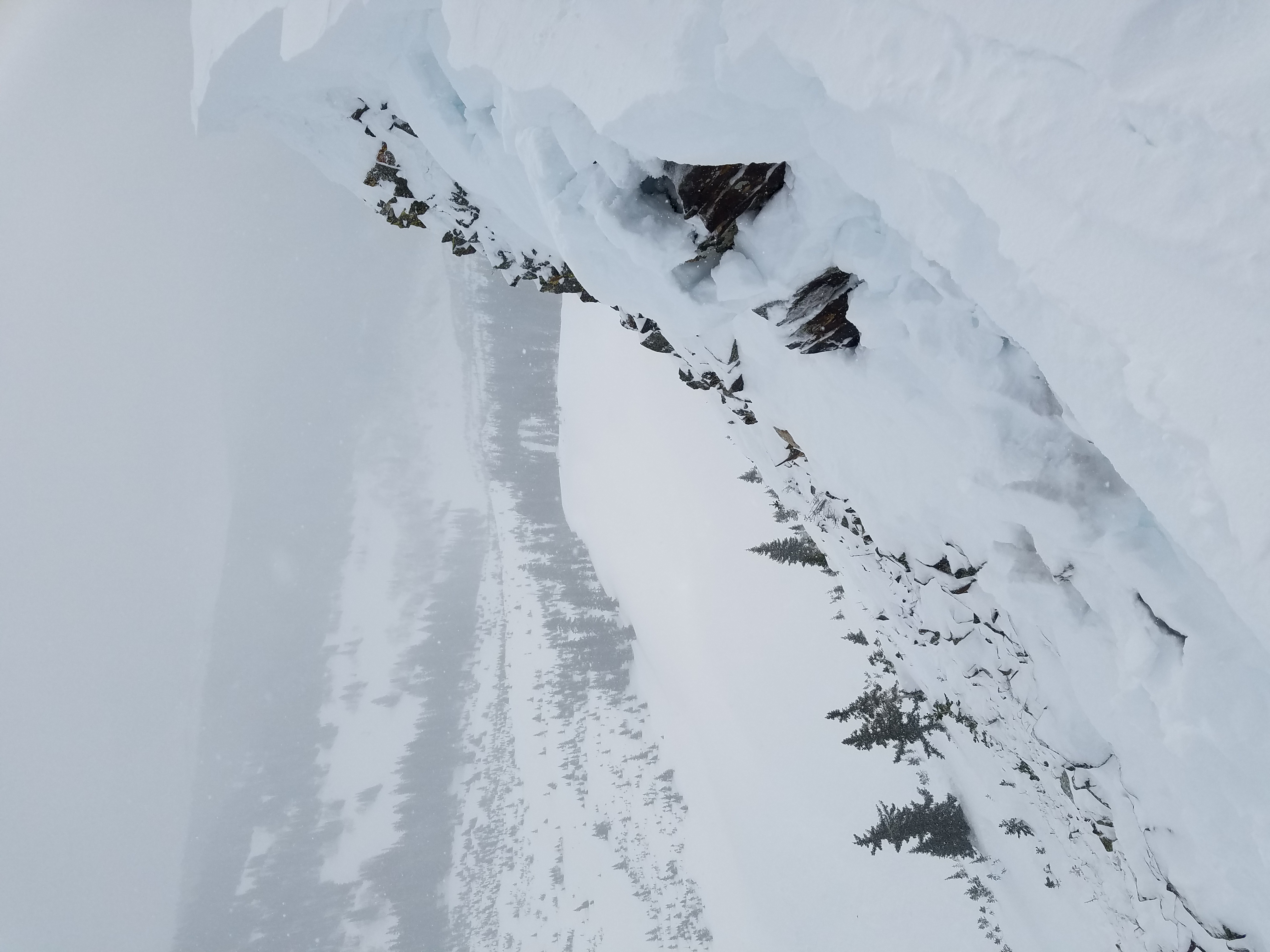
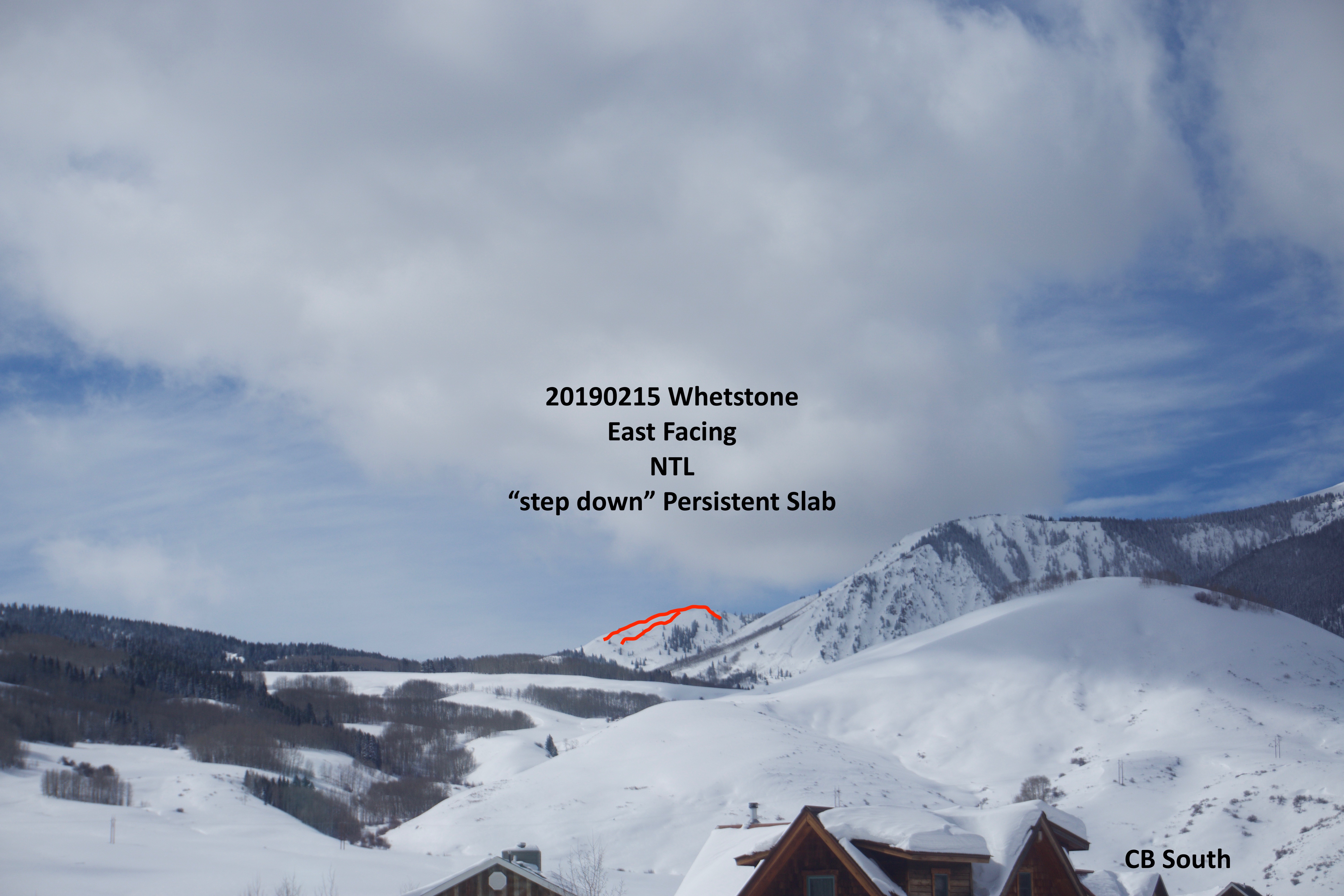
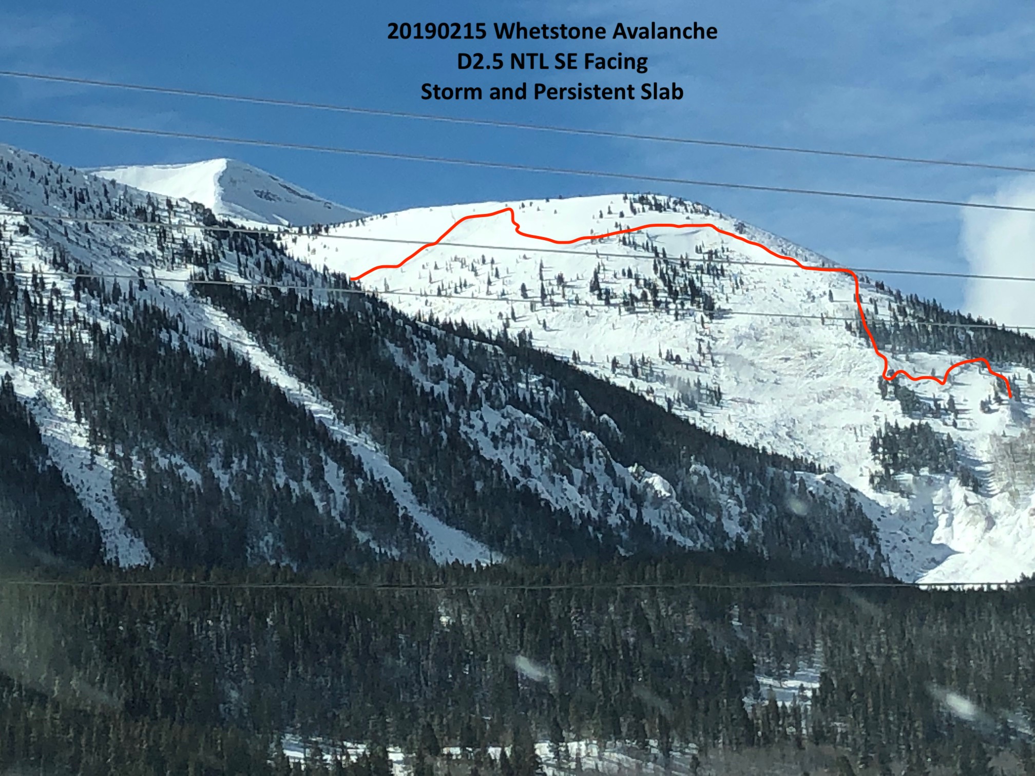
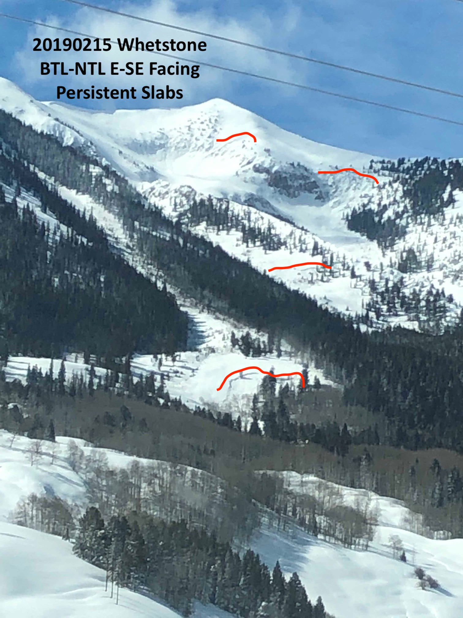
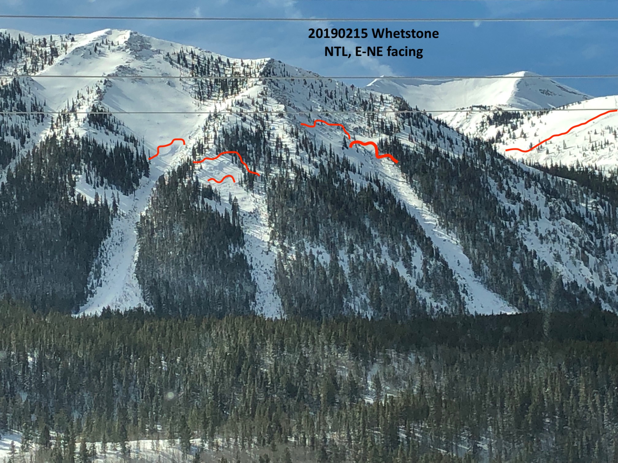
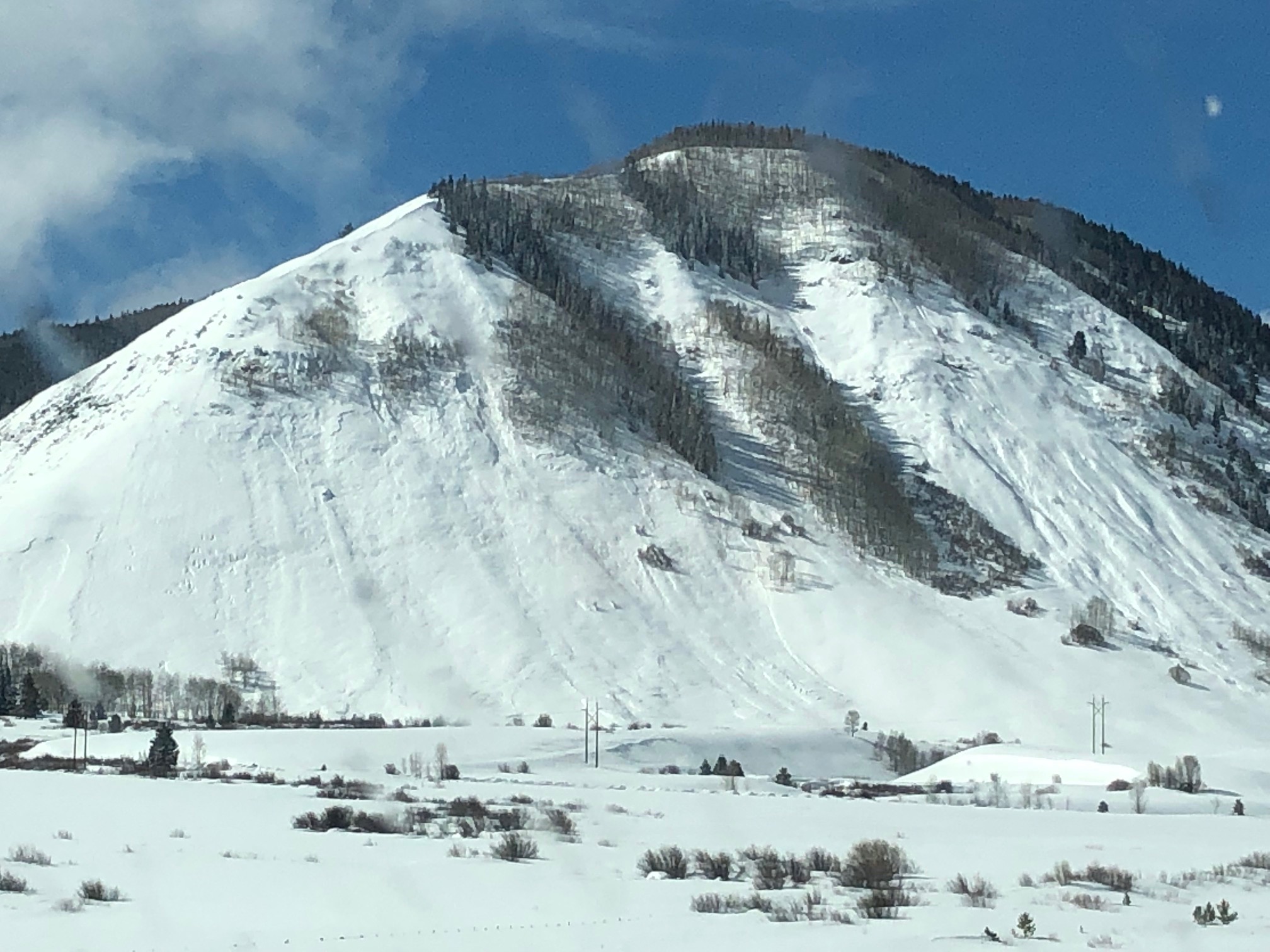
Whetstone and Gibson Avalanches
Location: Crested Butte Area
Date of Observation: 02/15/2019
Name: Ian Havlick
Subject: Whetstone and Gibson Avalanches
Aspect: East, South East
Elevation: BTL-NTL
Avalanches:
Photos of observed avalanches yesterday (2/15) as storm departed. Persistent slab avalanches at varying elevations along 135 Corridor. Gibson Ridge avalanches were repeaters which slid earlier this season.
Weather: Partly Cloudy, clearing skies, balmy temperatures
Snowpack:
Photos:
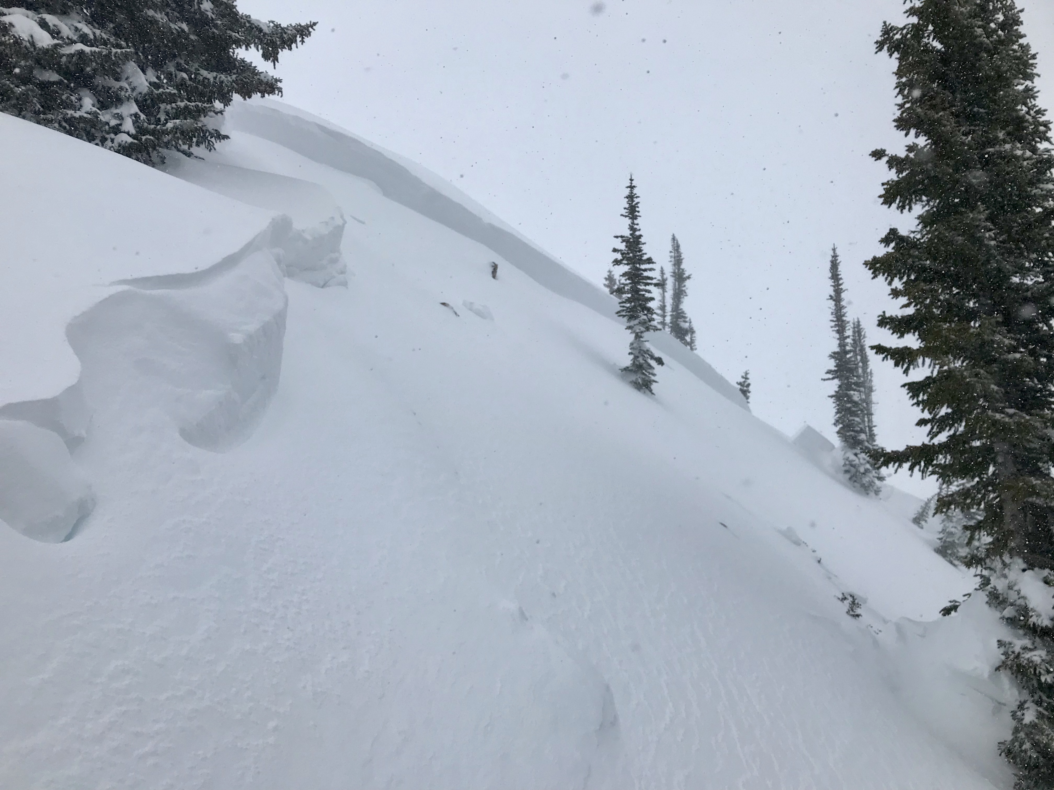
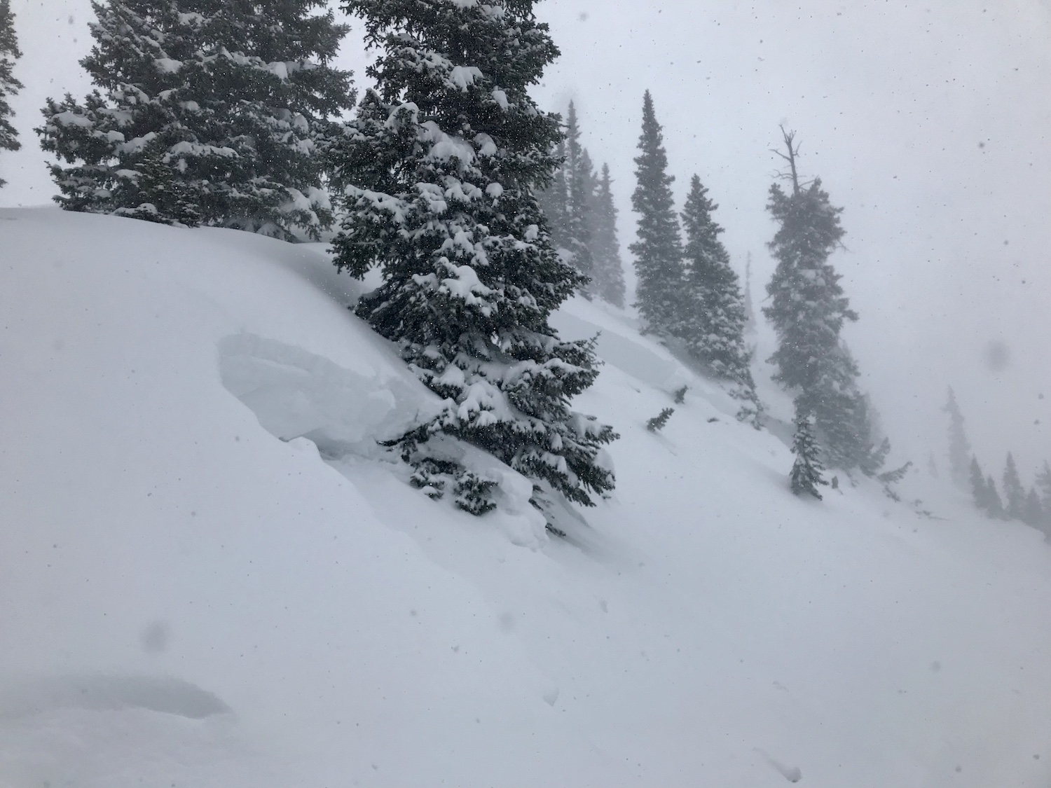
Fresh D2.5 Very Large Avalanche
Location: Crested Butte Area
Date of Observation: 02/16/2019
Name: Evan Ross
Subject: Fresh D2.5 Very Large Avalanche
Aspect: North East, South
Elevation: 9,200-11,600
Avalanches:
A fresh D2.5 slab avalanche was right off the Red Lady skin track before you hit the first exposed ridge, on the steep NE terrain to the climbers right. Measured about ~10cm’s of snow on the bed surface at 1pm. So this avalanche likely failed early this morning or yesterday afternoon. Lots of wind-loading on this slope so it may have failed naturally, or been remote triggered by the folks setting the skin track. The Crown averaged 2.5 to 3ft and failed in the upper snowpack. I was not able to get below the crown to see if the weak layers was at the old snow surface or in the late January interfaces. On the parts of the slope that had avalanched earlier this season the avalanche had stepped down to ~30cm’s above the ground and the crown grew to 4 to 5ft in places.
Weather: At lower elevations the winds were moderate and blowing from the west down valley. Plenty of snow available for transport and drifting on open terrain features. At near treeline elevations westerly winds were moderate to strong and drifting snow was intense on open terrain features. The majority of snow available for transport has already drifted on the one open ridgeline we traveled while todays snow was just continuing to add fuel. Measured about 5cm of new snow in about 4hrs at 10,000ft today. Today’s storm totals were around 15cm at 10,000ft.
Snowpack: A nice and quiet snowpack where we traveled though we didn’t push it. No collapse observed. Kept the terrain choices to near or below 30 degrees on southerly facing slope and avoided drifted features. On southerly facing slopes the 2/15 crust was a real bitch, but thankfully it got buried by enough snow not deter the ski quality in the afternoon.
Photos:
Mountain Weather for 11,000ft
Date: 02/16/2019
Yet another wave of moisture will arrive early this morning and rapidly drop an additional 4-8” of snow across our forecast area with the western mountains favored. The heart of the storm and the peak intensity will move through this morning, around 0900. Then, orographic snow will thrive in the moist, cold, northwest flow, especially across Kebler and Schofield Pass areas. Temperatures will fall back into the teens, with overnight lows dipping below zero. The next small wave of snowfall looks to be Sunday evening, with a few more ripples passing the central Rockies into early next week, before a larger storm potentially Wednesday or Thursday. Old Man Winter ain’t done yet!
-
Today
High Temperature: 15-20
Winds/Direction: 15-30mph G60/SW
Sky Cover: Mostly Cloudy
Irwin Snow: 3-6″
Elkton Snow: 2-4″
Friend’s Hut Snow: 2-4″ -
Tonight
Low Temperature: -10 to -5
Winds/Direction: 5-15/W
Sky Cover: Decreasing clouds
Irwin Snow: 1-3″
Elkton Snow: 1-3″
Friend’s Hut Snow: 0-2″ -
Tomorrow
High Temperature: 7-10
Winds/Direction: 5-15/WSW
Sky Cover: Overcast
Irwin Snow: 0
Elkton Snow: 0
Friend’s Hut Snow: 0
Avalanches from 2/15 cycle
Location: Kebler Pass Area
Date of Observation: 02/15/2019
Name: Eric Murrow
Subject: Mostly Avalanches and few thoughts from 2/15 cycle
Aspect: North, North East, East, South East, South, South West, West, North West
Elevation: BTL, NTL, ATL
Avalanches:
Axtel – 3rd bowl NE, Antracites – NW bowl N-NE, ridge south of Ruby – E, Schuylkill – SE, Red Lady Bowl – SE, Climax – NE, Red Ridge – S, Whetstone N & E, above Copper Creek – SE, Avery – SE, Snodgrass – SW, Gothic – NE-E-S-SW, Long Lake – NE, Teocalli – SE, to name a few. Lots of aspects and elevations involved. The obvious key factor was wind-loading. Some step-downs in old layers on northerly, some step-downs on sunny slopes. There were few below treeline slides involving just the storm snow.
Weather: Good visibility around the range by 3pm. Periodic loading on to easterly aspects throughout the day.
Photos:


Weekly Snowpack/Weather Summary
Location: Paradise Divide Area
Date of Observation: 02/15/2019
Name: Zach Kinler
Subject: Weekly Snowpack/Weather Summary
Snodgrass NE – Abbey Lane
Location: Crested Butte Area
Date of Observation: 02/10/2019
Name: Chris Martin
Subject: Snodgrass NE – Abbey Lane
Aspect: North, North East, East
Elevation: 9800′
Avalanches:
N/O
Weather: Clear Day in the Elks.
Temps in high 20sF
Snowpack: Most recent storm snow on snodgrass is about 30cm thick and remaking 4F-F softness.
Snowpack is revealing a strongish mid pack.
The 3-4mm DH at basal level of snowpack 10-20cm thick is concerning on these NE aspects, has yet to be on a consolidation trend and is remaining dry. CTHSC on this layer and no propagation observed.
HS 135cm
23 degree incline
9814’ Aspect 40-50 degrees
CT SP down 30 cm in most recent storm snow.
ECTP 22 down 50-55cm on 1-2mm FC
CTHSC down 125cm 3-4mm DH uncosolidated and dry
Photos:
Red Lady
Location: Kebler Pass Area
Date of Observation: 02/15/2019
Name: TC
Subject: Red Lady
Aspect: South East, South
Elevation: 9,200-12,400
Avalanches:
Remotely triggered (from <1ft) a fast-moving R1D2 from the ridge as we were nearing treeline. Ran 500 vertical feet through steep, rocky terrain, dragging big rocks with it. Did not see any other notable naturals from the summit. The cornices on top of Red Lady bowl were surprisingly small. Had a safe and pleasant ski down the glades. Snow was wind affected and a bit grabby in places.
Weather: Socked in most of the morning; clearing as we approached the summit. Periods of light snow. Westerly winds increasing with elevation, with gusts in the 20-30 mph range.
Snowpack: 30 cm of new snow; heavy & dense. Obvious wind scouring & wind loading from westerly winds. Very little obvious signs of instability, with just one small collapse on the climb, and we were breaking trail the entire way.
Photos: