Cement Creek Area

CB Avalanche Center2014-15 Observations

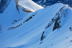
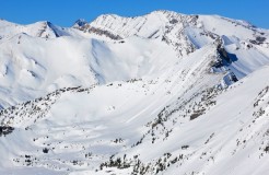
LOCATION: Cement Creek Area
DATE OF OBSERVATION: 01/31/2015
NAME: ADB
ELEVATION: BTL/NTL

WEATHER: Snowfall-S1. There was 1.5 cm of new snowfall. Calm. Temperature felt as if it hovered around 0 degrees Centigrade.

SNOWPACK: Storm snow: 2.5 to 7.5 cm. At Reno Divide, observed 10 cm wind slabs. Did about 5 test ski cuts: BTL-localized cracking and collapsing between 10 and 25 cm. NTL- collapsing up to 10 cm. Sun crust at bottom of layers, where collapsing occurred. Snow was wet BTL

Mountain Weather for Saturday, January 31st, 2015

CB Avalanche CenterWeather

Date: 01/31/2015

This Baja moisture has added a bit of spice into our forecast with continued upwelling of Pacific moisture into our area. Light snow should continue through midday before retreating southward. Winds and temperatures should stay similar to what we saw yesterday, light winds from the south, possibly switching to the N-NW later today with temperatures in the upper 20s to low 30s. Looking ahead, a few more disturbances may give us a few inches here and there, but no major pattern change is expected over the next 7-14 days..

Red Coon

CB Avalanche Center2014-15 Observations

LOCATION: Crested Butte Area
DATE OF OBSERVATION: 01/30/2015
NAME: Irwin Guides (CBMG)
SUBJECT: Red Coon
ASPECT: North, East, South East, South
ELEVATION: 9000-11,00

WEATHER: Overcast skies, snowing S1 throughout day, air temp at 11,800′ at mid-day was -5C, light winds from the South. Overall warm and wet day

SNOWPACK: Coral reef with a few cm’s on top on skin up to top of Coon summit. Dug a full profile pit just below summit at 11,800′ on a SE aspect on a 30* slope. HS 152; HST 7cms as of 1200. (see attached pit profile graph for more info). Easy failure with sudden collapse fracture character found with test results at 14cm’s down beneath a stout double crust/facet combo. More concerning was finding repeatable hard failure results with sudden planar fracture character on Compression Tests on a layer down 84cm’s down (Dec 13th interface).

UPLOADS:

Screen-Shot-2015-01-30-at-7.01.00-PM

Irwin Tenure

CB Avalanche Center2014-15 Observations

LOCATION: Kebler Pass Area
DATE OF OBSERVATION: 01/30/2015
NAME: Irwin Guides
SUBJECT: Irwin Tenure
ASPECT: E, SE, S, SW, W
ELEVATION: 10,000-12,000

WEATHER: Steady light snow all day. high 23 at ridge top, 28 at lake. light east winds.

SNOWPACK: 2” fell warm and wet, which should hopefully help bonding to the widespread Melt-freeze crusts. Not enough snow to test that theory yet. Current surface is pretty well broken up with old frozen tracks, wind scallops, and/or new tracks in the breaker crust. Expecting snowfall amounts to be too small to develop reactive storm slabs, and also expecting decent bonding to the crusts and broken up surfaces. Could change if we see more snowfall than forecaster.

Mountain Weather for Friday, January 30th, 2015

CB Avalanche CenterWeather

Date: 01/30/2015

A wobbling low pressure system near Baja will surge moist Pacific air northward today and tonight before high pressure from the north pushes drier, but not colder air, back into the area tomorrow evening. That pesky ridge over the west coast of California attempts to entrench itself once again but small, fast moving disturbances may give a few inches early next week.

Mountain Weather January 29, 2015

CB Avalanche CenterWeather

Date: 01/29/2015

Moisture streaming in from the southwest ahead of a closed low will keep mid to upper level cloud cover overhead for most of the day, under mild and calm conditions. Moisture deepens on Friday as the low moves onshore. With the favorable dynamics staying south, and a relatively warm system, we aren’t looking at a homerun with this one, but hopefully a base hit with 3-7″ in the mountains by sunset on Saturday. Flow shifts to a dryer northwest direction on Saturday afternoon and pushes the moist air out to our south.

Kebler Pass Area

CB Avalanche Center2014-15 Observations

LOCATION: Kebler Pass Area
DATE OF OBSERVATION: 01/28/2015
NAME: Zach Guy
SUBJECT: Kebler Pass Area
ASPECT: E, SE, S, SW, W
ELEVATION: 10,000-12,000 ft

AVALANCHES: None

WEATHER: Light graupel and gusty west winds tapered midmorning, with broken skies clearing to scattered. Minor snow transport in the morning.

SNOWPACK: Less than 1 cm of graupel fell this morning on widespread melt freeze crusts from the last 2 days of warm and sunny. These crusts exist on E, SE, S, SW, and W aspects at all elevations, of varying thickness. On a WSW slope at 11,500 feet, a couple handpits showed the new melt freeze crust about 2” thick and pencil hardness on average, supportive on skis, and up to 4” thick and supportive to boot pen where the slope tilted more SW. Everything in the hand pit was refrozen, no freewater.

UPLOADS:

avalanche on snodgrass

CB Avalanche Center2014-15 Observations

LOCATION: Crested Butte Area
DATE OF OBSERVATION: 01/28/2015
NAME: patrick donahue
SUBJECT: avalanche on snodgrass
ASPECT: North East, East
ELEVATION: 11,000


AVALANCHES: set off one slide that slid on old rain crust for 15 feet and then stepped down to the ground. ran approximately 200+ yards (from top to bottom of california bowl on snodgrass. crown was approximately 2 1/2 feet. bed surface was basel facets. no one was caught. propagated roughly 15-25 feet R1 D1+

WEATHER: partly cloudy around 32 degree F

SNOWPACK:

UPLOADS:

Mountain Weather January 28, 2015

CB Avalanche CenterWeather

Date: 01/28/2015

A weak disturbance passes to our north today, bringing a chance for an inch or two of snow under continued mild temperatures and some gusty winds. Thursday will be cloudy and warm as transient and weak upper-level ridge builds. We are happy to escort January out the door, but it might be leaving with a fight. A moisture-rich closed low moves across Arizona on Friday into Saturday. Models are currently showing favored snowfall for Southern Colorado, but those closed lows can wobble around like a drunk guy at the Talk of the Town. Lets hope it stumbles closer to the Elk Mountains.

Ruby Range

CB Avalanche Center2014-15 Observations

LOCATION: Kebler Pass Area
DATE OF OBSERVATION: 01/27/2015
NAME: Evan Ross
SUBJECT: Ruby Range
ASPECT: South, North West
ELEVATION: 11,000-13,000

AVALANCHES: Several recent loose wet avalanches on east and west aspects from the last 48 hours. A couple failed on these same aspects today. All of these avalanches where small, D1-1.5’s with a few D2’s in areas with lots of vertical relief.

WEATHER: Clear Sky over the Ruby Range and Elk Mountains. Clouds moving in from the west at the end of the day. Hot temps and no wind.

SNOWPACK: Alpine northwest slopes were a mixture of facets to the ground, near surface facets over a supportive slab, wind buff, or shallow hard wind slabs. The snow surface was cold and dry on this aspect all the way down to 10,800ft. On south and southwest aspects in the alpine the snow surface was wet for about 5cm and moist down 10-20cm deep on average, in the afternoon.

UPLOADS: