Mountain Weather for 11,000ft

CB Avalanche CenterWeather

Date: 04/11/2019

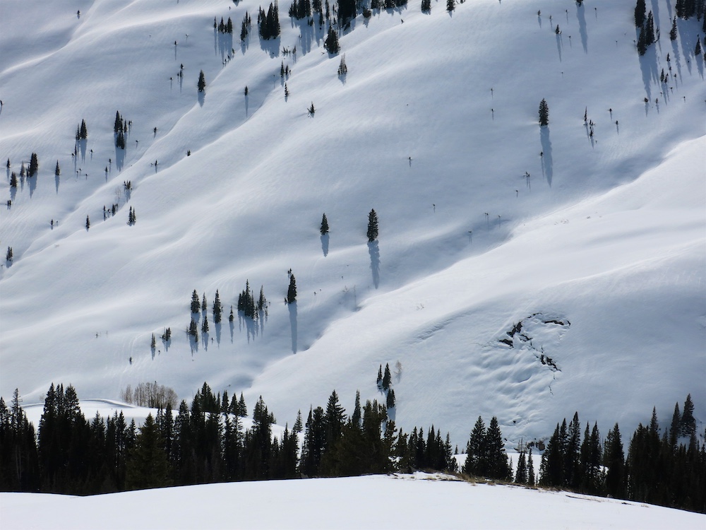
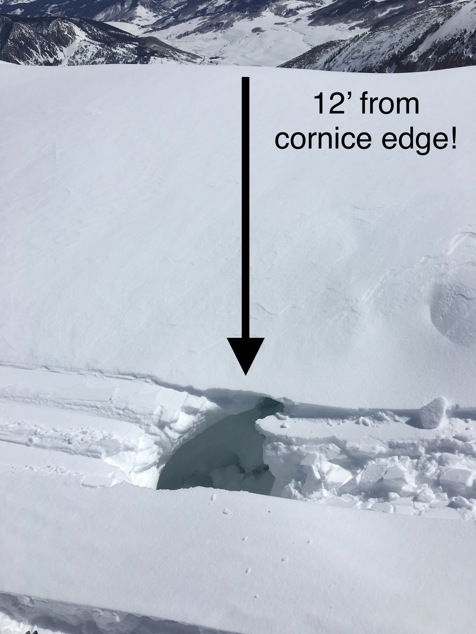
The low-pressure system, from yesterday, produced from 3″ to 10″ of snow as of 5am this morning. The low-pressure center has moved to the east of Colorado, but residual moisture will continue to stream into the area under NW flow. This wind direction will favor locations from Kebler Pass to Schofield Pass with lesser amounts for the interior parts of the range. Up to an additional 2″ to 4″ could fall today for the snow favored areas. Winds will remain out of the NW for the day and will continue to blow hard enough to transport the new snow. Looking towards Friday and the weekend, models are showing another system moving into the area, but it does not look impressive and may only produce showery precipitation into the weekend.

  • Today

    High Temperature: 23 to 28
    Winds/Direction: 12 to 22, NW
    Sky Cover: Overcast
    Irwin Snow: 2 to 4″
    Elkton Snow: 1 to 3″
    Friend’s Hut Snow: 0 to 2″

  • Tonight

    Low Temperature: 8 to 13
    Winds/Direction: 6 to 16, WNW
    Sky Cover: Mostly Cloudy
    Irwin Snow: 0 to 2″
    Elkton Snow: 0 to 2″
    Friend’s Hut Snow: 0 to 1″

  • Tomorrow

    High Temperature: 29 to 34
    Winds/Direction: 5 to 15, W
    Sky Cover: Mostly Cloudy
    Irwin Snow: 0 to 1″
    Elkton Snow: 0 to 1″
    Friend’s Hut Snow: 0 to 1″

fresh refresh

CB Avalanche Center2018-19 Observations

Location: Kebler Pass Area
Date of Observation: 04/10/2019
Name: Eric Murrow

Subject: Fresh Refresh
Aspect: North, North East, East, South East, South
Elevation: 9,200′ – 11,500′

Avalanches: nada

Weather: Overcast skies with snow ranging from S-1 to S2 from 1pm to 430pm. Winds had already shifted to the NW by 1pm. Wind speeds were generally in the 10’s but some gusting reaching up to 30 at ridgetop at 11,500′. Precip fell as rimed particles and some graupel.

Snowpack: New snow accumulations reached 5″ at 430pm. Just over 2″ fell between 1 and 430pm. Poked around on a variety of aspects at ridgetop looking for fresh drifts with deepest being around 6 or 7″, Very minor cracking, 1 foot, on the driftiest features. All aspects, expect due north above 11,200ish” had a crust at new/old interface. Southerly aspects near treeline had crust 3″ thick underneath the new snow. Steepest terrain features produced minor skier triggered sloughs.
Free water on NE facing slopes had perculated down from 20 to 40cm from the surfaces. Most slopes above 11,000′ regardless of aspect had drained/froze any liquid water by the PM. Upper snowpack below around 11,000′ continued to hold moist snow below a very thin, weak crust from the previous night’s warm temperatures.

Photos:

Mountain Weather for 11,000ft

CB Avalanche CenterWeather

Date: 04/10/2019

Old man winter is making a comeback today. A strong and cold low-pressure system is moving into Colorado this morning. Although temperatures are relatively warm early this morning, they will continue to drop as the system approaches. Light snowfall began around 1 am and will likely ramp up around mid-morning. The possibility of short periods of intense snowfall exists during the day. Along with the snow will be very gusty winds which will drift the new snow in open terrain. Winds will shift from the SW, this morning, to the NW as the system passes over the state. Snowfall will taper off this evening, but NW flow will keep light orographic snowfall going through tonight and into tomorrow. Temperatures will be unseasonably cold on Thursday with high temperatures only reaching the 20’s.

  • Today

    High Temperature: 26 to 31
    Winds/Direction: 13 to 23, G40 W
    Sky Cover: Overcast
    Irwin Snow: 4 to 7″
    Elkton Snow: 4 to 7″
    Friend’s Hut Snow: 3 to 6″

  • Tonight

    Low Temperature: 5 to 10
    Winds/Direction: 12 to 22, NW
    Sky Cover: Overcast
    Irwin Snow: 1 to 3″
    Elkton Snow: 1 to 3″
    Friend’s Hut Snow: 1 to 3″

  • Tomorrow

    High Temperature: 20 to 25
    Winds/Direction: 10 to 20, NW
    Sky Cover: Mostly Cloudy
    Irwin Snow: 1 to 3″
    Elkton Snow: 1 to 3″
    Friend’s Hut Snow: 1 to 3″

Mountain Weather for 11,000ft. Tuesday, April 9.

CB Avalanche CenterWeather

Date: 04/09/2019

It’s day three of Mom Natures, Bring Back The Heat Festival. Since the shirtless people didn’t gather on Elk Ave yesterday to reflect the suns heat as requested, Mama has decided to really bring the heat on this final day. Colorado is sitting on the backside of a high-pressure ridge. Warm air is being pulled up into the area on southwest flow and we’ll see those high temps jump another few degrees today. Both valley temps in the area and mountain temps will jump into the 50’s. Winds will be light through most of the day and start to pick up in the afternoon, while the sky will be partly cloudy and increase late in the afternoon. You best get your hot party on today, because it’s all about to change.

An approaching low-pressure system will bring increasing moisture late this afternoon with building clouds. A cold front looks to arrive on Wednesday morning with a big drop in temperatures and the arrival of snow. Winter is coming back baby! Snow showers will continue on Wednesday through Wednesday night with storm totals ranging from 5 to 10 inches by Thursday morning. Lite snow showers may continue on Thursday, as we await the next low presser system or storm #2 to arrive on Friday. Unsettled weather then takes us into the weekend. There will be some breaks in the weather of course but all and all we are looking to a return to winter coming up.

  • Today

    High Temperature: 46 to 50
    Winds/Direction: 10 to 20, SW
    Sky Cover: Partly Cloudy
    Irwin Snow: 0
    Elkton Snow: 0
    Friend’s Hut Snow: 0

  • Tonight

    Low Temperature: 24 to 28
    Winds/Direction: 12 to 22 G30, SW
    Sky Cover: Mostly Cloudy
    Irwin Snow: 1 to 2
    Elkton Snow: 1 to 2
    Friend’s Hut Snow: 1 to 2

  • Tomorrow

    High Temperature: 22 to 26
    Winds/Direction: 10 to 20, WNW
    Sky Cover: Overcast
    Irwin Snow: 6 to 8
    Elkton Snow: 5 to 7
    Friend’s Hut Snow: 2 to 3

Mountain Weather for 11,000ft. Monday, April 8.

CB Avalanche CenterWeather

Date: 04/08/2019

We’re starting into day two of Mom Natures Bring Back The Heat Festival. Sure is nice to have Mama remind us of what April can be like. Today mountain temperatures are going to spike into the forties, while valley temperatures may hit 50. Yesterday I took my shirt off in an attempt to reflect some of that heat back to the sun. Maybe if we group up and line Elk Ave we’ll have a greater effect?

On Tuesday the winds will increase from the southwest and pull in even warmer air for Mom Natures final day of the Bring Back The Heat Festival. After that festival, a low-pressure system rolls in, with a cold front to back it up, as we see a return to winter. It looks like we could have a game on refresh of new snow starting Wednesday and into Thursday. Unsettled weather looks to remain on Friday with the next storm that will take us into the start of the weekend.

  • Today

    High Temperature: 42 to 46
    Winds/Direction: 5 to 15 WNW
    Sky Cover: Mostly Clear
    Irwin Snow: 0
    Elkton Snow: 0
    Friend’s Hut Snow: 0

  • Tonight

    Low Temperature: 26 to 30
    Winds/Direction: 2 to 13, W
    Sky Cover: Partly Cloudy
    Irwin Snow: 0
    Elkton Snow: 0
    Friend’s Hut Snow: 0

  • Tomorrow

    High Temperature: 46 to 50
    Winds/Direction: 10 to 20, SW
    Sky Cover: Partly Cloudy
    Irwin Snow: 0
    Elkton Snow: 0
    Friend’s Hut Snow: 0

The Melt Is Back On

CB Avalanche Center2018-19 Observations

Location: Paradise Divide Area
Date of Observation: 04/07/2019
Name: Evan Ross

Subject: The Melt Is Back On
Aspect:
Elevation: 9,000-13,200

Avalanches: Fresh Loose Wet Avalanches were observed at all elevations, but primarily at near and below treeline elevations that faced east to south to west. This avalanche problem was also stretching into NE facing slopes. Many loose wet avalanches stayed small and within the new snow, however some were starting to gouge deeper into the snowpack and become larger in size.

A Large Wet Slab Avalanche was also reported on a ENE aspect of Gibson Ridge, BTL, just outside of Crested Butte.

Weather: Clear sky for the first half of the day, becoming mostly cloudy by the late afternoon. Light winds with some moderate gusts at upper elevations.

Snowpack: Heading out the valley in the morning, the snow surface had only formed a soft crust overnight with moist snow below. Returning in the afternoon the lower elevation snowpack was becoming unsupportive and punchy on east to south to west aspects and up to an observed 11,500ft on a southerly aspect. Skiing on Treasury Mountain in the alpine still held great cold pow on true north and had an ok warm snow surface on a southerly facing slope in the early afternoon.

A 5 person group of snowmobiles tagged many summits in the Paradise Divide area and tested many slopes. It didn’t appear that they triggered any avalanches. They were also smart with their terrain choices and had moved on to slopes not in the direct sun by the afternoon.

Mountain Weather for 11,000ft. Sunday, April 7.

CB Avalanche CenterWeather

Date: 04/07/2019

Last nights’ small storm is moving out and the sky will be clearing this morning. A fairly flat high-pressure ridge will be building in today, with increasing temperatures and dry weather through Tuesday. Some bits of moisture look to make their way over Colorado at times bringing some high clouds, but generally, we’ll see mostly clear sky. High temperatures will be on the increase each day, taking us up to Tuesday. By Tuesday, valley temperatures will be reaching into the 50’s while 11,000ft temperatures look to hit the high 40’s. Those temperatures will see a big drop on Wednesday as a cold front move in, with the next low-pressure trough bringing back snow showers on Wednesday into Thursday.

  • Today

    High Temperature: 35 to 39
    Winds/Direction: 5 to 15, WNW
    Sky Cover: Mostly Clear
    Irwin Snow: 0
    Elkton Snow: 0
    Friend’s Hut Snow: 0

  • Tonight

    Low Temperature: 23 to 27
    Winds/Direction: 5 to 15, W
    Sky Cover: Mostly Clear
    Irwin Snow: 0
    Elkton Snow: 0
    Friend’s Hut Snow: 0

  • Tomorrow

    High Temperature: 39 to 43
    Winds/Direction: 5 to 15, W
    Sky Cover: Mostly Clear
    Irwin Snow: 0
    Elkton Snow: 0
    Friend’s Hut Snow: 0

Dry-ish snow ATL

CB Avalanche Center2018-19 Observations

Location: Crested Butte Area
Date of Observation: 04/05/2019
Name: Steve Banks

Subject: Dry-ish snow ATL
Aspect: North East, East
Elevation: 12,000

Avalanches:

1 x loose wet pushed out on steep SE face in a radiator bowl feature.
Skier on ridge punched into cornice on travers even being 12’ back from the edge.

Weather: Mostly clear skies with West winds 15-20 mph, warm temps and strong solar.

Snowpack: SE slopes at ridgetop became mount to wet in the recent new snow and could be pushed into D1 sized wet loose avalanche in some places. Low angle North had a firm crust NTL and BTL, but soft, punchy more of wind crust on steeper ATL.
NE-N slopes at and above 12,000’ still held dry snow, but it is becoming affected by warm temperatures especially where protected from cooling winds.
Photos:

Mountain Weather for 11,000ft

CB Avalanche CenterWeather

Date: 04/06/2019

Colorado is looking at a weak trough passing through today which looked promising but now looks like a few scattered inches of snow this evening before high pressure returns tomorrow. With a warm and sunny trend to start next week, we can look ahead to the middle of the week for another potential spring storm heading our way. Expect sun and warm temperature this morning to give way to increasing cloudiness and light snow tonight.

  • Today

    High Temperature: 35-40
    Winds/Direction: W, 5-15 mph
    Sky Cover: Increasing clouds
    Irwin Snow: 0 to 1″
    Elkton Snow: 0 to 1″
    Friend’s Hut Snow: 0 to 1″

  • Tonight

    Low Temperature: 20-25
    Winds/Direction: 5 to 15, WSW
    Sky Cover: Mostly Cloudy
    Irwin Snow: 0 to 2″
    Elkton Snow: 0 to 2″
    Friend’s Hut Snow: 0 to 2″

  • Tomorrow

    High Temperature: 33-38
    Winds/Direction: NW, 10-20 mph
    Sky Cover: Decreasing clouds
    Irwin Snow: 0
    Elkton Snow: 0
    Friend’s Hut Snow: 0

Weekly Snowpack/Weather Summary

CB Avalanche Center2018-19 Observations, 2018-19 Weekly Snowpack Summaries

Location: Paradise Divide Area
Date of Observation: 04/05/2019
Name: Zach Kinler

Subject: Weekly Snowpack/Weather Summar

Avalanches:

No new observed.

Weather: Tair @ 12:31 was + 6.5C. Strong solar with very light southerly winds. FEW

Snowpack: At 10,400′ HS: 241 cm. Free water was observed ~63 cm from the surface. This is ~38 cm above the 2/28 interface. Continued settlement from warm weather has consolidated the snowpack to nearly knife hard mid pack.

Photos: