Date of Observation: 05/10/2023
Name: Zach Guy
Zone: Southeast Mountains
Route Description: Copper Creek and West Brush Creek areas, viewed from Whiterock
Observed avalanche activity: Yes
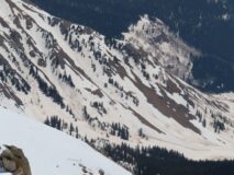
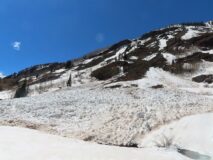
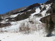
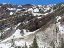
Avalanches: Numerous previously undocumented D2 to D3 wet slabs likely ran during our April 9 to April 13 wet cycle. I coded their failure dates during the peak of the cycle 4/10 – 4/11, although I suspect activity was distributed across a wider date range than that.
Photos:
-
-
Several D2-D3 wet slabs below the west side of Teo.
-
-
A D3 wet debris pile that crossed Copper Creek trail about a mile upstream of Judd Falls.
-
-
A D2.5 wet debris pile near Copper Creek trail about a mile upstream of Judd Falls.
-
-
A D3 wet debris pile above Copper Creek trail about a mile upstream of Judd Falls.
-
-
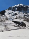
Wet debris pile below the Spork. (Previously documented)
-
-
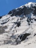
Wet debris below the East face of Gothic, most of this was previously documented except one.
Estimated avalanche date: 04/11/2023
Number of Avalanches: 2
Location
Location: West Brush Creek
Location Specific:
Start Zone Elevation: NTL: Near Tree Line
Aspect: W
Characteristics
Trigger: Natural
Trigger modifier:
Type: Wet Slab
Failure Plane: Old snow
Size
Relative Size: R3 medium
Destructive Size: D3 – could destroy a car, wood-frame house, or snap trees
Avg. crown height (inches):
Avg. width (feet):
Avg. vertical run (feet):
Involvements
# of people caught:
# of partial burials:
# of full burials:
Additional comments: West side of Teo. Failure date estimated, likely between 4/10 and 4/13. These had not released by mid-day on 4/10 when I was in this drainage.
Estimated avalanche date: 04/11/2023
Number of Avalanches: 1
Location
Location: West Brush Creek
Location Specific:
Start Zone Elevation: NTL: Near Tree Line
Aspect: W
Characteristics
Trigger: Natural
Trigger modifier:
Type: Wet Slab
Failure Plane: Old snow
Size
Relative Size: R2 small
Destructive Size: D2 – could bury, injure, or kill a person
Avg. crown height (inches):
Avg. width (feet):
Avg. vertical run (feet):
Involvements
# of people caught:
# of partial burials:
# of full burials:
Additional comments: West side of Teo. Failure date estimated, likely between 4/10 and 4/13. This had not released by mid-day on 4/10 when I was in this drainage.
Estimated avalanche date: 04/10/2023
Number of Avalanches: 2
Location
Location: Copper Creek
Location Specific:
Start Zone Elevation: BTL: Below Tree Line
Aspect: SE
Characteristics
Trigger: Natural
Trigger modifier:
Type: Wet Slab
Failure Plane: Old snow
Size
Relative Size: R3 medium
Destructive Size: D3 – could destroy a car, wood-frame house, or snap trees
Avg. crown height (inches):
Avg. width (feet):
Avg. vertical run (feet):
Involvements
# of people caught:
# of partial burials:
# of full burials:
Additional comments: Below peak 12001. Failure date estimated, likely between 4/9 and 4/13. Many downed trees, and the debris crossed Copper Creek trail. Given destructive debris, I suspect these were wet slabs that started near or below treeline, but start zone evidence has melted out to dirt now.
Estimated avalanche date: 04/10/2023
Number of Avalanches: 1
Location
Location: Copper Creek
Location Specific:
Start Zone Elevation: BTL: Below Tree Line
Aspect: SE
Characteristics
Trigger: Natural
Trigger modifier:
Type: Unknown
Failure Plane: Old snow
Size
Relative Size: R3 medium
Destructive Size: D2.5
Avg. crown height (inches):
Avg. width (feet):
Avg. vertical run (feet):
Involvements
# of people caught:
# of partial burials:
# of full burials:
Additional comments: Below peak 12001. Failure date estimated, likely between 4/9 and 4/13. Several snapped aspens. Either wet slab or wet loose, but start zone evidence has melted out to dirt now.
Estimated avalanche date: 04/11/2023
Number of Avalanches: 1
Location
Location: Gothic Mountain
Location Specific:
Start Zone Elevation: NTL: Near Tree Line
Aspect: E
Characteristics
Trigger: Natural
Trigger modifier:
Type: Wet Slab
Failure Plane: Old snow
Size
Relative Size: R2 small
Destructive Size: D2.5
Avg. crown height (inches):
Avg. width (feet):
Avg. vertical run (feet):
Involvements
# of people caught:
# of partial burials:
# of full burials:
Additional comments: Below East Face.
6265


