Date of Observation: 04/02/2021
Name: Ben Pritchett
Zone: Northwest Mountains
Location: Roadside observations around Crested Butte. Late day wet snow check-in. Assess depth of melt-water infiltration in relation to potential Wet Slab avalanche problems.
Aspect: North, North East, East, West, North West
Elevation: 10,000
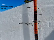
Avalanches: Photo 1: A wet snow surface on a mostly dry snowpack at 10,000′ on a northeast-facing slope. April 2, 2021.
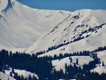
Photo 2: A pattern of small natural avalanches on southeasterly-facing slopes near and above treeline. April 2, 2021
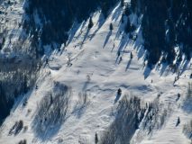
Photo 3: A small natural avalanche on a south-facing slope above treeline. April 2, 2021
Photo 4: An example of an easterly-facing slope that could become dangerous without a freeze at mid-elevations.
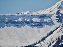
Photo 5: A pair of recent slab avalanches that ran on the east to northeast-facing slopes off the Ruby/Owen ridge, and Scarp Ridge.
Estimate* 3/29/21- 1- >TL- E-C-N-R1-D1
Estimate* 3/29/21- 1- >TL -SE-C-N-R1-D1
Weather: Ridgeline Wind Speed: Calm
Wind Loading: None
Temperature: 53 F
Sky Cover: Few
Depth of Total Snow: 120 cm
Weather Description: 53 degrees at 10,000′ at 3pm.
Snowpack: Near 10,000 feet, on northwest through north to northeast-facing slopes, the snowpack was mostly dry, with meltwater draining down only around 10cm so far. Below and near treeline, the shoulder aspects of east and west look the closest to developing a Wet Slab avalanche problem. The steeper southeast through south to southwest-facing slopes are wetted to the ground and melting out quickly. At the Butte snotel at a similar elevation, it did not freeze Thursday night, and it may not again tonight (Friday night). In the worst case rocky terrain features rocky with a shallow snowpack, human-triggered Wet Slab avalanche may become possible by late afternoon Saturday. If there’s another night without a freeze on Saturday, natural Wet Slab avalanches might run Sunday.
Photos:


