Date of Observation: 02/02/2021
Name: Eric Murrow
Zone: Southeast Mountains
Location: Snodgrass front side
Aspect: North East, East, South East, South
Elevation: 9,300′ – 10,600′
Avalanches: nothing new observed
Weather: Mostly cloudy skies early transitioned to partly cloudy skies in the afternoon. Mild air temps – felt a bit above freezing (weather stations confirmed temps in upper 30’s). Calm winds.
Snowpack: Traveled through a quiet area on the front side of Snodgrass as snow depths in this area match well with other shallow snowpack zones in the Southeast Mountains. East through South slopes was moist at the surface to the highest elevation I traveled – 10,600′. Some northeast meadows were moist below about 10k. Ski penetration on east and northeast slopes was around 6 to 8 inches with snowpack depths around 70cm on east and 90cm on northeast; boot penetration to ground everywhere. Settlement in the snowpack over the past few days was noticeable. Slabs above the mid-January weak layer were in the 25 to 30cm range with 4finger hardness at bottom of slab which I think fits nicely with other sheltered areas in the Southeast Mountains (snowpack tests all produced moderate ECTN scores). Overall the snowpack is weak and even a modest loading event, say around 10 to 12inches, will likely start producing avalanches.
Photos:
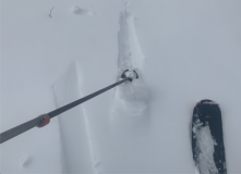
- Moist snow surface on a low angled, northeast-facing meadow at 10k.
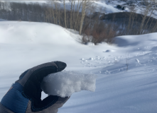
- Soft crust formed on easterly aspects below treeline – pinwheels visible in background.


