Mountain Weather 12/6/2017

CB Avalanche CenterWeather

Date: 12/06/2017

It’s pretty simple. Cool, and dry for the foreseeable future. This afternoon and through tomorrow, we’ll see a few clouds and an increase in winds as a small arctic blip strafes over the Front Range.

Bottom line, our deflector shield of high pressure parked over the Pacific coast remains operational. This anomalous ridge on the left coast coupled with a deep digging trough of low pressure over the Midwest will keep the north flow pouring down on the Rockies and Crested Butte today, and tomorrow, and the day after, and the day after…

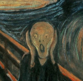
Have you ever seen Edvard Munch’s painting The Scream? Well that’s what the atmosphere over the Pacific looks like right now.

Mountain Weather 12/5/2017

CB Avalanche CenterWeather

Date: 12/05/2017

The little storm that blew is now well in our rearview mirror, having left behind seasonably chilly temps and not much else. In the short term, we can expect light North winds, clear skies and growing inversions, meaning warmer temps up high and colder temps in the valley floors as the cold air sinks.
Looking further ahead, we’re in for a dry spell. Or as the National Weather Service put it, the high pressure now covering the western US “spells doom for Pacific moisture reaching inland.” Long-range weather models show this giant deflector shield in the sky protecting us from any pesky snowflakes for at least the next week. Looking towards this weekend, as Emperor Palpatine of Star Wars said: “Oh, I’m afraid the deflector shield will be quite operational when your friends arrive.”

Mountain Weather December 4th, 2017

CB Avalanche CenterWeather

Date: 12/04/2017

The 2018 December drying out phase has begun as last nights low-pressure system is heading east. Temperatures have returned to near normal for this time of year, ya that’s way colder then what we’ve been used to lately. Last nights strong winds are on the decrease this morning as well. Clouds will dissipate through the day with a few potentially lingering clouds along the crest of the Ruby Range towards Paradise Divide. The extended December forecast is looking dry with very a small chance of a very small storm later in the week.

Mountain Weather 12/3/2017

CB Avalanche CenterWeather

Date: 12/03/2017

Currently on Sunday morning conditions are still calm with thin clouds and mild temperatures but that’s all about to change later today. A low-pressure system moving into the northwest US this morning will be passing to our north through tomorrow afternoon. The big news for us with this system will be the winds. Pressure gradients are going to tighten as this trough dips into Colorado with wind gusts exceeding 50mph in the mountains. Those southwest winds will build this afternoon and peak this evening. A cold front will also drastically drop temperatures for the coming day. As it passes this evening we will see a quick burst of snow. The typical snow favored spots in the Kebler Pass and Paradise Divide areas could pick up 4-5” of snow overnight but these areas will be right on the southern edge of the snow forecast, so confiding is low. Conditions will mellow through the day tomorrow as we stare down a dry extended forecast for the week and beyond.

Mountain Weather 12/2/2017

CB Avalanche CenterWeather

Date: 12/02/2017

High and dry today with a few passing high clouds ejecting out of the desert southwest. Temperatures will again run several degrees above normal, with light west-southwest winds at higher elevations. Tomorrow will again be mild, as southwest flow strengthens and brings us that desert warmth ahead of a minor disturbance arriving midday. Don’t expect too much out of this storm, but maybe if we undersell it, the storm will over deliver? Long term looks bleak if you are hoping for snow.

Mountain Weather Forecast for Friday, December 1st, 2017

CB Avalanche CenterWeather

Date: 12/01/2017

Above average temperatures, light southwest winds, and dry weather look to dominate today and into the weekend. We should see very warm temperatures forecast for Sunday, as warm southwest winds will kick up ahead of the Monday disturbance. Unfortunately, Monday’s storm looks to fizzle without dropping much snow. I’ll save you the dread of looking at the long range models and give you a hint… Fried eggs through the first week of December (at least)..

Mountain Weather 4/14/2017

CB Avalanche CenterWeather

Date: 04/14/2017

Clear sky Thursday night allowed for snow surfaces to freeze while valley temperatures dropped into the upper 20’s and 11,000ft temperatures to drop to right near freezing. High temperatures Friday should be should a couple degrees cooler then yesterday with another small decrees on Saturday. A low pressure trough will be moving by north of Colorado during this time period. This passing trough has brought increased gusty winds to the alpine for Friday morning into midday. By Sunday night into Monday, another passing trough looks to sag a little further south and at this point only looks to bring some increased clouds. There are a few chances for a change in weather looking out to next week, but currently nothing to promising. May be time to start shoveling your snowbanks into the melted out portions of your yard to start watering.

Mountain Weather 4/12/2017

CB Avalanche CenterWeather

Date: 04/12/2017

Its never a good sign for winter weather in the near future when weather discussions are talking about the fire conditions. Dry and warm as far as the eye can see could be the end of this weather discussion. Well, ok a few more points can be made. Cloud cover is decreasing this morning as we are back in warm and dry southwest flow. The pressure gradients will tighten tomorrow and we’ll see an uptick in gusty alpine winds with hight temperatures a couple degrees warmer then today. Winds looks to ease again by the weekend with high temperatures dropping a couple degrees. It all comes back to warm and dry weather into the extended forecast with a few blips of increased clouds maybe this weekend or next week.

Mountain Weather 4/10/2017

CB Avalanche CenterWeather

Date: 04/10/2017

Its going to be like Groundhog Day all week. Only each day your going to get hotter and more sweaty. The sun will come up each day, (feel like I will nail that part of the forecast), the temperatures will rise, westerly winds will be light to moderate, the sun will go down and boom! We’ll do it all over again the next day.

A blip in the westerly flow may bring some increased clouds late Tuesday into Wednesday. Then southwest flow will allow high temperatures to ramp up even more on Thursday and Friday. Settle in folks, its going to be a nice dry week ahead.

Mountain Weather 4/9/2017

CB Avalanche CenterWeather

Date: 04/09/2017

Well, at least last night’s storm brought the wind… and there’s cold air on the way.

A windy trough of low pressure is blowing across the western US this morning, with the substantial moisture tracking far away in the Northern Rockies. This morning as the trough axis passes overhead a cold front will drop temperatures several degrees and shift winds to the Northwest. For the last day of the ski area, expect a cool breezy day, with clouds decreasing as the day goes on. The winds look to calm down as the lifts stop spinning.

For those partaking in the traditional closing day rituals, you might consider bringing a wind-proof sock.